Local Plan 2015-2030 Preferred Options for Consultation
Chapter 4: Development Management Policies
4.1 This section of the Plan deals with fundamental aspects of development planning in the Borough, and contains Policies which seek to achieve the Strategic Objectives of the Plan and provides a detailed suite of Development Management policies which support the Spatial Strategy and Core Policies of the Plan. The Council seeks to promote and secure sustainable development. This means directing development to locations which are supported, or capable of being supported, by effective transport provision, leisure, community and other essential services, while minimising harm to the environment and protecting the Green Belt.
Managing Growth
Strategic Objective 1
Direct development growth to the existing urban areas of
Brentwood, Shenfield and West Horndon in locations well
served by existing and proposed local services and
facilities.
Strategic Objective 2
Manage development growth to that capable of being
accommodated by existing or proposed infrastructure, services
and facilities.
(18) Policy DM1: General Development Criteria
Proposals for development will be expected to meet the following criteria:
- have no adverse effect on visual amenity, the character or appearance of the surrounding area
- provide satisfactory means of access to the site for vehicles, cyclists and pedestrians and parking and servicing arrangements
- ensure the transport network can satisfactorily accommodate the travel demand generated and traffic generation would not give rise to adverse highway conditions or highway safety concerns or unacceptable loss of amenity by reason of number or size of vehicles
- have no adverse effect on health, the environment or amenity due to the release of pollutants to land, water or air (light, noise pollution, fumes, vibration, smells, smoke, ash, dust and grit)
- cause no unacceptable effects on adjoining sites, property or their occupiers through excessive noise, activity or vehicle movements; overlooking or visual intrusion; harm to or loss of outlook, privacy or daylight/sunlight enjoyed by occupiers of nearby properties
- take full account of opportunities to incorporate biodiversity in and around developments
- when considering the impact of development on the significance of a designated heritage asset, greater weight should be given to the assets conservation
- result in no net loss of residential units
In exceptional circumstances, where the Council considers the need for the development outweighs any harm caused, the council will require suitable compensatory measures, either on-site or off-site.
Proposals for uses within or near residential areas which may give rise to unacceptable levels of pollutants will need to be accompanied by an environmental statement, including details of suitable abatement measures, in order to assess their likely effects on residents. Where effects are judged unacceptable and cannot be addressed through sensitive siting or pollution abatement technology permission will be refused.
Alternative Approach
1. To have no policy and rely instead on the National Planning Policy Framework and ad hoc consideration of proposals on a case by case basis.
Reason for rejection: The Council believes the preferred approach will provide a more transparent, consistent and fairer basis for considering planning proposals than having no policy.
2. To include criteria in the preferred policy in other policies in the plan.
Reason for rejection: Previous experience has shown an approach similar to the preferred policy to be effective although this approach might be equally effective.
Justification
4.2 New development should make a positive contribution to the quality of the environment and Borough. This policy is intended to help achieve this.
4.3 Development should not harm the amenities of occupiers in nearby properties. Therefore, protecting the privacy and amenity space of nearby properties by avoiding excessive overlooking or loss of light resulting from new development are key considerations. New developments should be sympathetic to the character and form of neighbouring properties and surroundings ensuring they are not overbearing and do not look out of place.
4.4 In light of the imperative to deliver sustainable development, the Borough Council expects development to adopt environmental best practice and pollution prevention measures in relation to groundwater, drainage, lighting, noise, impacts on health, the environment and amenity to avoid, address or mitigate adverse impacts that might otherwise arise. It will be important therefore that all development proposals take into account the environmental impact of proposed activities at an early stage in the planning process and incorporate measures needed to address this.
4.5 In order for a scheme to be acceptable, development will be required to make satisfactory arrangements for vehicular, cycle and pedestrian access into the site and for parking and servicing within the site. Any traffic generated by the development should be capable of being satisfactorily accommodated by the transport network and not give rise to unacceptable highway conditions, safety and amenity concerns as a result of the number or size of vehicles.
4.6 Changes of use from residential, especially within or adjoining commercial centres, can involve the loss of smaller accommodation, for example flats above shops and small terraced units, which make a valuable contribution to the housing stock offering housing choice and affordability and responding to demographic change, notably a fall in the average household size. Such locations are sustainable being near services, facilities within walking distance and public transport. A residential presence in commercial areas maintains activity after shops and offices close, enhances community safety and retains the mixed-use feel of shopping areas. Making the best use of existing housing helps resist pressure to release additional land from the Green Belt. The Council therefore aims to retain existing dwellings and resist their loss. Similarly, the Council will seek to retain community facilities and services where needed, or secure their replacement, to at least an equivalent standard and convenience.
Evidence
Annual Monitoring of previous policy usage shows a criteria based policy along the lines being proposed to be extremely helpful in guiding the appraisal of and decisions on development proposals.
Brentwood Borough Annual Monitoring Reports
National Policy
NPPF, paragraph 120: Planning policies
“should ensure that new development is appropriate for its
location. The effects (including cumulative effects) of
pollution on health, the natural environment or general
amenity, and the potential sensitivity of the area or
proposed”
Planning policies and decisions should aim to:
- avoid noise from giving rise to significant adverse impacts on health and quality of life as a result of new development;
- recognise that development will often create some noise and existing businesses wanting to develop in continuance of their business should not have unreasonable restrictions put on them because of changes in nearby land uses since they were established; and
- identify and protect areas of tranquillity which have remained relatively undisturbed by noise and are prized for their recreational and amenity value for this reason. (NPPF paragraph 123)
- promote the retention and development of local services and community facilities in villages, such as local shops, meeting places, sports venues, cultural buildings, public houses and places of worship”. (NPPF, paragraph 28) and guard against the unnecessary loss of valued facilities and services, particularly where this would reduce the community’s ability to meet its day-to-day needs” (paragraph 70)
Consultation
Responses highlight the importance of managing development to minimise any harm that might be associated with it, such as traffic impact or amenity issues.
Target
Policy requirements met
No net loss of residential units
Indicator
Planning permissions/conversions/change of use for existing residential properties
Development contrary to policy
Delivery
Development Management
(4) Policy DM2: Effective Site Planning
Planning permission will be granted for development proposals only where the planning and design of buildings and spaces:
- arrange access points, routes within the site, public and private spaces, building forms and ancillary functions in an efficient, safe, workable, spatially coherent and attractive manner
- incorporate existing site features of value
- design-out opportunities for crime and anti-social behaviour
- safeguard the amenities of occupiers or any nearby properties by ensuring that their character and appearance is sensitive to the context and surroundings
Alternative Approach
Incorporate site planning context within a design and/or public realm policy.
Reason for rejection: Site planning is included as a separate Development Management Policy to highlight its importance in order to ensure development proposals address the need to create links with adjoining sites, incorporate features of value and design-out crime. Creating a high quality public realm is a specific aim in Brentwood Town Centre Regeneration Strategy and this is reflected in the Plan with the inclusion of separate specific policies.
Justification
4.7 Site planning is at the heart of good design and making successful places. A primary consideration when site planning is the nature and function of the spaces between buildings. However small, sites should be well connected, safe and properly landscaped. Public and private spaces should be clearly differentiated.
4.8 Site planning should incorporate existing site features such as trees and ponds and built-forms of value. Spaces that are safe and welcoming in the long-term depend on eliminating the opportunity for anti-social activity through the placing of building fronts and treatment of spaces. Site planning should ensure that buildings relate successfully to one another and have no adverse impact on the amenity of occupiers.
Evidence
Brentwood Town Centre Regeneration Strategy (2010)
Design Council Cabe Panel Review Brentwood Local Plan
Workshop (2012)
Essex Design Guide (2005, to be updated late 2013)
The Sign of a Good Place to Live, Building for Life 12
(2012, Building for Life Partnership)
Urban Place Supplement SPD (2007)
National Policy
NPPF paragraph 7: Creating a high quality
built environment is a key part of the social role in the
requirement to contribute to achieving of sustainable
development.
NPPF paragraphs 56-68 ‘Requiring Good Design’
NPPF paragraph 69: Planning can play an important role in facilitating social interaction and creating healthy, inclusive communities. Planning policies should aim to achieve places which promote safe and accessible developments, containing clear and legible pedestrian routes and high quality public space.
NPPF paragraph 70:To deliver the social, recreational and cultural facilities and services the community needs, planning policies and decisions should:
- plan positively for the provision and use of shared space, community facilities (such as local shops, meeting places, sports venues, cultural buildings, public houses and places of worship) and other local services to enhance the sustainability of communities and residential environments;
- take account of and support local strategies to improve health, social and cultural well-being for all, and deliver sufficient community and cultural facilities and services to meet local needs.
Target
Policy requirements met
Indicator
Development monitoring
Delivery
Development Management
(11) Policy DM3: Residential Density
Proposals for new residential development should take a design led approach to density which ensures schemes are sympathetic to local character and make efficient use of land.
Residential densities will be expected to be 30 dwellings per hectare net or higher unless the special character of the surrounding area suggests that such densities would be inappropriate.
Higher densities, generally above 65 dwellings per hectare net, will be expected in town and district centres or other locations with good public transport accessibility.
Alternative Approach
1. To set no minimum density and instead have a policy to secure a design led approach which seeks to achieve efficient use of land on a case by case basis.
Reason for rejection: Achieving the Council’s housing aspirations as set out in this plan, both numerically and in terms of dwelling size, type and affordability, will require developers to use land efficiently. There is a risk that by setting no minimum density this may not happen. As a consequence more land would be needed to provide the same number of homes than would otherwise be the case. Relying solely on a design led approach is riskier than specifying minimum densities which would apply in most circumstances under the preferred option and make it more likely that the plan will deliver housing requirements.
2. To have no policy on density
Reason for rejection: The same concerns that apply to Alternative 1 apply here only more strongly.
Justification
4.9 Efficient land use is essential in a Borough like Brentwood where land is scarce, and enables new homes to be provided without encroaching on the countryside. Good design makes it possible to develop in a way that is sympathetic to local character, uses land efficiently and creates or maintains a high quality living and working environment. The right density will depend on the scheme, dwelling mix, site characteristics and location.
4.10 The Council considers it reasonable to expect proposals to achieve densities of at least 30 dwellings per hectare except where this would harm the special character of an area, have an adverse transport impact or cause harm to residential amenities. Densities of 65 dwellings to the hectare or more will generally be expected in locations with good public transport accessibility.
4.11 To determine how much land is required to meet housing requirements, consideration has been given to the number of homes a given area can sustainably accommodate based on site and location characteristics. Efficient land use is critical to the delivery of this plan. Without it there will be more pressure to release Green Belt to accommodate new development or, alternatively, the number of new homes delivered will fall short of that planned and what would otherwise have been provided.
National Policy
NPPF paragraph 47: Local Planning
authorities should set out their own approach to housing
density to reflect local circumstances.
Evidence
BBC Residential Land Monitor
BBC Site Allocations technical paper (forthcoming)
Strategic Housing Land Availability Assessment (2011),
see density matrix assumptions
Urban Place Supplement SPD, BBC, (design guidance
prepared by Essex CC)
Target
Policy requirements met
Schemes developed in accordance with Essex CC Urban Place Supplement design principles
Indicator
% of developments in line with this policy
Delivery
Allocations
Development management decisions
Proposals reflect Urban Place Supplement design principles
(1) Policy DM4: Telephone Exchange
Redevelopment proposals for the Telephone Exchange shall include a mix of uses including residential with leisure/recreation and/or commercial office uses.
Alternative Approach
To have no policy. While redevelopment or refurbishment of this site is a long term objective, deliverability constraints mean this may be unachievable within the plan period.
Justification
4.12 The existing Telephone Exchange serving the area is on brownfield land in Brentwood town centre. Due to its height, the building is prominent. It is also visually unattractive and underused. Redevelopment here would provide an opportunity to utilise the site more efficiently and contribute towards the Borough’s development needs. A well-designed proposal would significantly enhance the character of the surroundings and adjacent Conservation Area.
National Policy
NPPF paragraph 20: in drawing up Local
Plans, local planning authorities should: identify priority
areas for economic regeneration, infrastructure provision and
environmental enhancement.
NPPF paragraph 137: local planning authorities should look for opportunities for new development within Conservation Areas and World Heritage Sites and within the setting of heritage assets to enhance or better reveal their significance.
Target
Appropriate future use, sympathetic refurbishment or redevelopment of Telephone Exchange site providing for the needs of Brentwood Town Centre and enhancing the neighbouring Conservation Area.
Indicator
Development Monitoring
Delivery
Development Management
Involvement of town centre partners such as Brentwood Renaissance.
Economic Prosperity
Strategic Objective 3
Foster a prosperous, vibrant and diverse local economy by attracting new commercial investment in order to maintain high and stable levels of economic and employment growth
Strategic Objective 4
Expand and enhance Brentwood Town Centre’s retail offer, in particular, opportunities for high quality niche shopping
Strategic Objective 5
Promote and encourage the continued regeneration of Brentwood Town Centre to provide high quality public realm and mixed use developments
Strategic Objective 6
Optimise the social and economic benefits that arise from Crossrail for the benefit of residents and visitors to the Borough
4.13 This Plan aims to facilitate local economic development by providing additional employment land, supporting job creation and responding to business needs. In line with the Corporate Plan, the emphasis will be on encouraging high value business and a discerning approach to economic growth. This recognises the Borough’s land constraints and need to maintain the high quality environment which makes it a popular destination for business, workers and residents. Spatial Policy S3 sets out land and job growth requirements.
4.14 The following Development Management policies set out the means by which economic prosperity and growth will be achieved through protecting existing employment land and premises and allocating and encouraging provision of new sites. Policies should be read in conjunction with Spatial Policies S3 and S4, Core Policies CP11 Strong and Competitive Economy and CP12 Thriving Town Centres.
(6) Policy DM5: Employment Development Criteria
Development for employment uses (Class B1, B2 or B8) will be encouraged provided it satisfies all the following criteria:
The proposal should:
- be of a scale and nature appropriate to the locality
- provide appropriate landscaping and screening
- be accessible by public transport, walking and cycling
- ensure vehicular access avoids residential streets and country lanes, and the proposal does not give rise to significant traffic movements within rural areas
- be easily accessible to main arterial routes (A127, A12, M25) with appropriate parking provision
- where a significant amount of movement is generated, development proposals should be accompanied by a Transport Assessment in accordance with Policy CP13
Alternative Approach
No alternative policy has been identified. The Council considers the preferred approach to be essential in order to deliver sustainable development.
Justification
4.15 All new employment proposals, both within and outside allocated employment areas, will need to comply with the criteria set out in this policy to protect the amenities of residents and other sensitive uses within the vicinity of the developments. In particular, the transport impacts of all proposals will need to be assessed to ensure that vehicular access and traffic generation do not result in unacceptable levels of traffic and congestion on unsuitable roads or within environmentally sensitive areas.
4.16 Employment sites can generate a large amount of movement for both vehicles and people. Where this is likely to occur, a Travel Plan will be required. To avoid any overspill of parked cars to surrounding residential streets or country lanes a satisfactory level of parking provision will need to be provided on site.
Evidence
Employment Land Review (2010)
Heart of Essex Economic Futures Study (2012)
National Policy
NPPF paragraphs 18-22: Building a strong,
competitive economy set out guidance on encouraging economic
growth.
NPPF paragraph 36: ...All developments which generate significant amounts of movement should be required to provide a Travel Plan.
Target
Encourage economic growth that is sympathetic with surrounding land uses and residents
Indicator
Monitoring use of policy to be published in the Council’s AMR
Delivery
Development Management
(10) Policy DM6: Areas Allocated for General Employment and Office Development
Within those areas allocated for general employment and office development listed below and on the Policies Map, the Council will seek to achieve and retain a wide range of employment opportunities. Planning permission will be refused for the redevelopment or change of use of business, offices, general industry and distribution sites or premises for non-Class B uses as defined by the Use Classes Order 1987 (as amended) unless:
- the proposal is for other non-residential uses that provide significant employment with no reasonable prospect of locating elsewhere in the Borough, and there is no identified need for the site or buildings for Class B uses
- the proposal is wholly for affordable housing, the site is vacant and development would not prejudice continuation of adjacent employment uses
- the proposal is for any other use and the application is supported by a statement of efforts made to secure re-use for Class B1-B8 or similar uses and other non-residential use that provides employment, which evidence demonstrates there is no realistic prospect of the site or buildings being used or re-used, including through redevelopment, for these purposes
- the site or buildings would be physically unsuitable for re-use for Class B1-B8 or similar use, even after adaptation (including sub-division into smaller units), refurbishment or redevelopment, in terms of siting, design, access, layout and relationship to neighbouring buildings and uses.
| Preferred Allocations | ||
| Site | Area (ha) |
|
| New employment land allocations | ||
| Brentwood Enterprise Park (M25 works site) (101A) | 23.41 | New employment allocation – brownfield site in Green Belt |
| Brentwood Enterprise Park (land at Codham Hall) (101B) | 4.04 | Existing employment uses on site, allocate land for employment to regularise uses. |
| Mountnessing Roundabout site (former scrapyard) (107) | 2.6 | New employment allocation – brownfield site in Green Belt (existing planning permission for hotel/leisure) |
| West Horndon strategic allocation | 5 (approx) | New employment land as part of West Horndon strategic allocation |
| The Old Pump Works, Great Warley Street (108) | 0.79 | Existing office development completed post 2005 Plan. Allocate in this Plan for employment. |
| Existing allocated employment land | ||
| Town Hall, Brentwood (110) | 1.09 | Allocated employment-offices in Local Plan (2005) |
| Childerditch Industrial Estate (112) | 11.25 | Allocated employment-general in Local Plan (2005) |
| Hallsford Bridge Industrial Estate (113) | 3.41 | Allocated employment-general in Local Plan (2005) |
| Hubert Road Industrial Estate (114) | 4.76 | Allocated employment-general in Local Plan (2005) |
| Hutton Industrial Estate (045) | 10.48 | Allocated employment-general in Local Plan (2005) |
| Upminster Trading Park (111) | 2.6 | Allocated employment-general in Local Plan (2005) (not on Policies Map, but included in Policy E1) |
| Brook Street employment area (115) | 1.25 | Allocated employment-general in Local Plan (2005) |
| Warley Business Park (116) | 3.22 | Allocated employment-offices in Local Plan (2005) |
| Ford Offices, Eagle Way, Brentwood (117) | 5.45 | Allocated employment-offices in Local Plan (2005) |
| BT Offices, London Road, Brentwood (118) | 3.5 | Allocated employment-offices in Local Plan (2005) |
| OCE offices, Chatham Way, Brentwood (119) | 0.45 | Allocated employment-offices in Local Plan (2005) |
| 47-57 Crown Street (120) | 0.12 | Allocated employment-offices in Local Plan (2005) |
| Mellon House, Berkley House and 1-28 Moores Place, Brentwood (121) | 0.52 | Allocated employment-offices in Local Plan (2005) |
| 1-7 & 16-26 St Thomas Road, Brentwood (122) | 0.22 | Allocated employment-offices in Local Plan (2005) |
| 7-9 Shenfield Road, Brentwood (123) | 0.06 | Allocated employment-offices in Local Plan (2005) |
| 38 Ingrave Road, Brentwood (adjacent to Town Hall) (124) | 0.07 | Allocated employment-offices in Local Plan (2005) |
| North House, Ongar Road, Brentwood (125) | 0.18 | Allocated employment-offices in Local Plan (2005) |
Alternative Approach
1. Allow for a market led approach with different types of uses on B-use land, such as leisure or entertainment uses that also create employment.
Reason for rejection: The Borough’s land use is constrained by the need to protect the Green Belt, quality of the area and surrounding countryside. This means that employment land for B-Class uses needs to be protected. Evidence suggests there is most scope to secure future economic growth in office-based sectors. Therefore the need to protect allocated floorspace is even more important. This policy position aims to protect B-Use land unless criterion can be proved.
2. Provide growth by relying solely on intensifying and/or redeveloping existing employment sites and allocations.
Reason for rejection: This would approach would make it harder to deliver required growth in job numbers and additional employment land.
Alternative Allocations
Some sites identified as employment allocations could be considered for alternative uses. Were alternatives considered more appropriate this could have potential effects on housing and economic growth over the plan period, both positive and negative. The table below sets out options.
| Site | Reasonable Alternative | Reason |
| Former A12 works site (106) | Employment | Site once used as a works site for A12 improvements. Currently site has large area of hardstanding (brownfield in Green Belt). Site could provide for employment uses. |
Justification
4.17 A thriving and entrepreneurial business community is vital for the success of the Borough’s economy. Therefore, in areas allocated for general employment and office development on the Policies Map, the presumption is that existing uses will be retained, and that proposals entailing loss of employment premises and sites without replacement will be resisted. The Council will work with businesses within these areas to encourage them to adapt and respond to changing economic conditions in order to support business growth and ensure continuing economic vitality.
4.18 Within the central areas of Brentwood and Shenfield, and former M25 Works Site, areas are identified where further Class B1 office development will be permitted, including mixed-use developments. However, such areas are considered unsuitable for other types of development which could generate employment, in view of the nature of these areas, which include shops, community facilities, leisure uses and housing.
4.19 Where an application is made under clause (c) the applicant should provide information regarding:
- Length of time the property has been unused for employment purposes.
- Period during which it has been actively marketed for such purposes, which includes the possibility of redevelopment and provides evidence of marketing (not normally less than 24 months). Evidence should show where the property has been marketed including publications and property journals as well as clear advertisement on site.
- Prices at which the land and buildings have been marketed during this period, which should reflect similar property in the locality.
- A list of all expressions of interest during this period.
- An evaluation of why it is considered that the property has failed to attract interest from potential occupiers or for redevelopment for B Class use.
4.20 Estimated capacity is based on calculating on employment density by sector type as set out in the Heart of Essex Economic Futures Study.
Evidence
Employment Land Review (2010)
Heart of Essex Economic Futures Study (2012)
National Policy
NPPF paragraph 160: Local planning
authorities should have a clear understanding of business
needs within the economic markets operating in and across
their area. To achieve this, they should:
- work together with county and neighbouring authorities and with Local Enterprise Partnerships to prepare and maintain a robust evidence base to understand both existing business needs and likely changes in the market; and
- work closely with the business community to understand their changing needs and identify and address barriers to investment, including a lack of housing, infrastructure or viability.
NPPF paragraph 161: Local planning authorities should use this evidence base to assess:
- the needs for land or floorspace for economic development, including both the quantitative and qualitative needs for all foreseeable types of economic activity over the plan period, including for retail and leisure development;
- the existing and future supply of land available for economic development and its sufficiency and suitability to meet the identified needs. Reviews of land available for economic development should be undertaken at the same time as, or combined with, Strategic Housing Land Availability Assessments and should include a reappraisal of the suitability of previously allocated land;
NPPF paragraphs 22 Planning policies should avoid the long term protection of sites allocated for employment use where there is no reasonable prospect of a site being used for that purpose. Land allocations should be regularly reviewed. Where there is no reasonable prospect of the site being used for the allocated employment use, applications for alterative use of land or buildings should be treated on their merits having regard to market signals and the relative need for different land uses to support sustainable local communities.
Target
Wider choice of employment opportunities through provision of additional B1, B2 and B8 uses, as set out in Policy S3
Net change in floorspace for B1, B2 and B8 as a result of planning permissions and changes of use
Indicator
Monitoring use of policy to be published in the Council’s AMR
Delivery
Development Management
(3) Policy DM7: Land at Mountnessing Roundabout (Former Scrapyard), Roman Road
Land at Mountnessing Roundabout (site ref: 107), as set out on the Policies Map, is allocated for employment development (Use Classes B1, B2 and B8) according to the following criteria:
- Employment uses and jobs provided on site are consistent with the economic strategy set out within this Plan, and support the vitality and viability of Brentwood Town Centre and other Borough centres.
- Development is of a high design standard, meeting aspirations to enhance this location as a key gateway to Brentwood.
- Landscaping and planting should be used to create a buffer and provide improved visual amenity between the site and surrounding land, minimising any amenity impacts.
Development proposals should be accompanied by a Transport Assessment in accordance with Policy CP13 (Sustainable Transport)
Alternative Approach
A hotel and leisure use.
Reason for rejection: The preferred approach focusing on B1, B2 and B8 is intended to facilitate provision of new jobs and business in the Borough. However, this offers a good location for a hotel and related leisure use and the site currently has planning permission for a hotel. This approach may therefore be equally worth consideration.
Justification
(1) 4.21 Land at Mountnessing roundabout is previously developed and has a current planning permission to provide jobs for hotel/leisure use. It is considered that this site would be appropriate to provide employment floorspace which in turn would contribute towards economic growth, new business and new jobs in the Borough. This location is a key gateway to Brentwood from the A12 (Junction 12). It provides excellent transport links via the highways network and is accessible by public transport to both Brentwood Town Centre and Shenfield Station.
Target
Development in accordance with policy
Indicator
Development monitoring
Delivery
Development Management
(6) Policy DM8: Supporting the Rural Economy
The Council will seek to develop a sustainable rural economy by supporting appropriate, small scale rural enterprise. Proposals to diversify the range of economic activities on a farm or in a rural area will be supported where proposals:
- benefit the local community and do not adversely affect quality of life or the amenity of local residents
- conserve and enhance local character and maintain the openness of Green Belt
- are consistent in scale and environmental impact with their rural location
- have no detrimental impact on existing village shops and business
- demonstrate traffic generation can be satisfactorily be accommodated by the existing or planned local road network, ensuring access arrangements are acceptable to the scale and type of development with no adverse effect on highway safety
- have no unacceptable effect on water quality or flooding, watercourses, biodiversity or important wildlife habitats
Alternative Approach
No alternative policy has been identified. The Council considers the preferred approach essential in order to deliver sustainable development.
Justification
4.22 The Council recognises it can be beneficial for farms to diversify use of land and buildings for other suitable activities or development. These might include converting redundant barns for B1 business use or workshops, storage, farm shops, bed and breakfast, energy crops, or acceptable sport and leisure uses like campsites. These can be important in supplementing agricultural business income to ensure long-term viability and, alongside suitable small-scale rural enterprise and provide rural job opportunities. Suitable uses will allow more efficient use of buildings and land while fitting in with farming practices, rural surroundings and maintaining openness of the Green Belt.
4.23 Farm shops are well used in the Borough and by residents living nearby and play a significant role within the local convenience goods shopping hierarchy. Farm shops provide home grown and local produce, support local agriculture and provide sustainable, healthy alternatives to supermarkets by reducing food miles and providing access to fresh, seasonal produce. The Council supports this form of farm diversification provided facilities are appropriate to their rural location and would not lead to unrelated business in the countryside or unacceptable levels of activity in the Green Belt.
4.24 Council policy seeks to protect and enhance local retail patterns, including safeguarding traditional village shops and facilities in order to retain important rural services where they can best serve the local community. Rural infrastructure such as local roads should not be unacceptably affected by traffic generation as a result of diversification.
4.25 The design and construction of new rural development must be of high quality and sympathetic to local character. Proposals may be required to safeguard the employment function of the development from other uses through planning conditions/planning gain mechanisms.
Evidence
Employment Land Review (2010)
Heart of Essex Economic Futures Study (2012)
Retail Study Appendix (Survey of shopping behaviour)
(2011)
National Policy
NPPF paragraph 28: Planning policies
should support economic growth in rural areas in order to
create jobs and prosperity by taking a positive approach to
sustainable new development. To promote a strong rural
economy, local and neighbourhood plans should:
- Support the sustainable growth and expansion of all types of business and enterprise in rural areas, both through conversion of existing buildings and well designed new buildings;
- Promote the development and diversification of agricultural and other land-based rural businesses;
- Support sustainable rural tourism and leisure development that benefit businesses in rural areas, communities and visors, and which respect the character of the countryside. This should include supporting the provision and expansion of tourist and visitor facilities in appropriate locations where identified needs are not met by existing facilities in rural service centres; and
- Promote the retention and development of local services and community facilities in villages, such as local shops, meeting places, sports venues, cultural buildings, public houses and places of worship.”
NPPF paragraph 25 sets out that the “sequential approach should not be applied to applications for small scale rural offices or other small scale rural development.”
Target
Development in accordance with policy
Indicator
Development monitoring
Delivery
Development Management
(6) Policy DM9: New Retail and Commercial Leisure Development
To provide a sustainable network of local shopping and leisure provision, retail and commercial leisure development will be encouraged in the Borough’s Primary Shopping Areas, as set out in Core Policy CP12 and shown on the Policies Map. Provision for new leisure and retail is set out below.
| Retail allocations | ||
| Site | Area (ha) | Background |
| William Hunter Way car park site, Brentwood | 1.3 | Permission for mixed use development (retail/leisure/car parking/residential) |
| Baytree Centre, Brentwood | 1.34 | Opportunity for redevelopment of existing centre to provide net retail floorspace increase with residential units above |
| West Horndon opportunity area | - | Provision of retail to meet local needs as part of mixed-use development (strategic allocation) |
To facilitate consumer choice and strengthen vitality, viability and accessibility, proposed development should:
- be appropriate in scale and character to the local area
- be based on the sequential approach in accordance with national policy guidance
- have no detrimental impact on the vitality and viability of the centre or other centres nearby
- be easily accessible by public transport, foot and cycle
- be fully integrated with the existing shopping area
- contribute to an area’s attractiveness, accessibility and vibrancy by providing a range of shops to meet local needs
- provide opportunities for small, independent ‘niche’ shops
- not result in subdivision of an existing large retail unit
- in Brentwood Town Centre, comply with guidance set out in the Brentwood Town Centre Shopfront Guidance SPD
Proposals for retail and commercial leisure development outside the Borough’s Primary Shopping Areas over 2,500 square metres will not be permitted unless an accompanying impact assessment can satisfactorily demonstrate that:
- the proposal would have no adverse impact on existing centres
- associated travel demand can be satisfactorily accommodated by the transport network
- the proposal does not give rise to any detrimental impact on amenities in the surrounding area
- travel by more sustainable forms of transport than the private car will be achieved
Alternative Approach
No alternative policy has been identified. The Council considers the preferred approach essential in order to deliver sustainable development.
Justification
4.26 The Borough’s main shopping centres are both vital and viable according to Brentwood Retail and Commercial Leisure Study (2011). Surrounding centres outside Brentwood continually seek to improve their offer, either through new floorspace or improvements to shopping environments. In order to compete, Brentwood Town Centre will need to build on existing strengths, notably its distinctive offer, an attractive and high quality shopping environment, ‘niche’ independent shops, convenience goods retailing, services, and evening entertainment such as cafes, bars and restaurants. Other Borough centres will need to develop in ways that maintain their attraction and encourage residents and workers to shop locally in a convenient, accessible and pleasant environment.
4.27 As set out in Policy CP12 Thriving Town and Local Centres, the Borough’s Primary Shopping Areas are:
| Town Centres: | Brentwood Town Centre |
| Shenfield, Hutton Road | |
| Village Centre: | Ingatestone High Street |
In addition, local shops and shopping parades in smaller centres provide key services to their local communities. These are defined as:
| Shopping Parades: | Small local shops and/or shopping parades serving local communities. Typically, these might include a small supermarket, newsagent, Post Office, pharmacy. |
4.28 In line with national guidance the Council aims to support the viability and vitality of existing shopping centres by directing new retail provision here and encouraging new investment and improvements. To ensure the Borough’s shopping centres continue to thrive in future, a sequential approach will be adopted with regard to the location of new retail provision which reflects the hierarchy of centres set out in Policy S1 and Policy C12. Any new major retail provision will only be permitted within those areas allocated for shopping purposes.
4.29 The Council seeks to retain existing large retail units. These should not be subdivided as they can be a major driver of footfall. Subdivision would reduce the ability to attract major retailers, potentially increasing pressure for out-of-town retail floorspace which in turn would undermine town centre viability.
Evidence
Brentwood Retail and Commercial Leisure Study
(2011)
Shopfront Guidance for Brentwood Town Centre SPD
(2010)
National Policy
NPPF paragraphs 23-27 set out the national
framework for shaping town centre policies. Relevant extracts
include:
Planning policies should be positive, promote competitive town centre environments and set out policies for the management and growth of centres over the plan period. In drawing up Local Plans, local planning authorities should:
- Recognise town centres as the heart of their communities and pursue policies that support their vitality and viability;
- Define a network and hierarchy of centres that is resilient to anticipated future economic changes;
- Promote competitive town centres that provide customer choice and a diverse retail offer and which reflect the individuality of town centres;
- Allocate a range of suitable sites to meet the scale and type of retail, leisure, commercial, office, tourism, cultural, community and residential development needed in town centres. It is important that needs for retail, leisure, office and other main town centre uses are met in full and are not compromised by limited site availability. Local planning authorities should therefore undertake an assessment of the need to expand town centres to ensure a sufficient supply of sustainable sites;
- Allocate appropriate edge of centre sited for main town centre uses that are well connected to the town centre where suitable and viable town centre sites are not available. If sufficient edge of centre sites cannot be identified, set policies for meeting the identified needs on other accessible locations that are well connected to the town centre;
- Set policies for the consideration of proposals for main town centre uses which cannot be accommodated in or adjacent to town centres
- Recognise that residential development can play an important role in ensuring the vitality of town centres and set out policies to encourage residential development on appropriate sites; and
- Where town centres are in decline, local planning authorities should plan positively for their future to encourage economic activity. (NPPF paragraph 23)
Target
Development in accordance with policy
Indicator
Development monitoring
Delivery
Development Management
(2) Policy DM10: Non-Retail Uses
Primary and Secondary frontages are set out in the Borough’s Primary Shopping Areas as shown on the Policies Map. Uses within these areas are as follows:
PRIMARY FRONTAGES
Proposals for retail development will be permitted within the Primary Frontage of Brentwood Town Centre. Further change of use within ground floor Class A1 premises to other Class A uses of the Use Classes Order will not be permitted.
SECONDARY FRONTAGES AND SHOPPING PARADES
Within ground floor premises in Brentwood Town Centre Secondary Frontage, Shenfield, Ingatestone and Local Shopping Parades, further A2, A3, A4 or A5 use will only be permitted where the proposal:
- would result in no more than two adjacent non-retail uses
- would result in no more than 40% of total units being used for non-retail uses
- would not prejudice the effective use of upper floors
- would not irreversibly preclude options to return property back to retail use
- retains a shopfront with windows and entrances which relate well to design of buildings and street-scene, complying with shopfront guidance where relevant
- demonstrates any potential related problems, such as noise and smell, can be overcome satisfactorily to protect amenities of surrounding residents. Details of extraction, filtration, refrigeration or air conditioning units should be submitted with any application.
Change of use to any other non-retail uses will not be permitted.
Alternative Approach
To not restrict non-retail uses in Borough Primary Shopping Areas through using Primary and Secondary Frontages.
Reason for rejection: The Council recognises that it is important to retain a mix of uses in Town Centres and Primary Shopping Areas, as the NPPF advises. Were non-retail uses not restricted then there is a risk that they would displace retail units. This Policy aims to strike a balance between uses and therefore retain retail units where possible. Primary and Secondary Frontages are used to manage different areas depending on the importance of keeping retail.
Justification
4.30 In order to retain and enhance the attractiveness and competitiveness of the Borough’s shopping centres and to meet local shopping needs, it is important to maintain a range of shopping facilities. To avoid an over-concentration of non-retail uses within Borough centres this policy aims to strike a balance between competing uses, ensure a broad range of shopping opportunities, provide for a reasonable dispersal of uses throughout the centre and integrate non-retail uses into the general shopping environment.
4.31 A Primary Frontage is identified in Brentwood Town Centre as the Borough’s main focus for retail. This is to ensure retail uses are maintained in the High Street. Secondary frontages allow for more flexibility of use, although a certain amount of retail should be retained. These are shown on the Policies Map for the Borough’s Primary Shopping Areas of Brentwood, Shenfield and Ingatestone. Local shops and parades are also included in criterion for Secondary Frontages to ensure a good mix of retail is retained.
4.32 Local shopping parades and individual shops within residential areas provide for the day-to-day needs of local communities. Such facilities are often valued by elderly people and those without access to private transport who often rely on facilities being available locally. These facilities provide a convenient and sustainable choice within walking distance.
4.33 Retail uses compete with a range of other uses for a presence within town centre shop frontages. Some uses, such as building societies, banks, estate agents, restaurants, takeaways etc, are beneficial since they attract people into the centre for services and entertainment and are often linked to a shopping trip. Restaurants, takeaways and public houses contribute to the attractiveness and vitality of an area, providing variety and activity during and outside normal business hours. However, too great a concentration of these uses can undermine the primary role of the town centre for retailing, leading to a reduction in the range and choice of goods available and potentially isolating some retailers from the main shopper/pedestrian flows upon which they depend. It is important therefore to avoid an over-concentration of non-retail uses, take care over their location and siting and ensure they incorporate window displays to overcome potential problems associated with the creation of “dead frontages”.
4.34 Proposals in Brentwood Town Centre should be in line with the adopted Shopfront Guidance SPD, designed to a high standard while retaining shopfronts.
4.35 Restaurants, public houses and takeaways can adversely affect neighbouring residents, due to late opening hours, noise, smell, litter and other anti-social behaviour. Core Policy CP12 sets expectations for after-hours uses and the wider night time economy in Borough centres. In order to best manage competing uses proposals will need to clearly set out how potential problems can be satisfactorily overcome. Planning conditions may also be used to manage this.
4.36 Feedback from consultation with the local community highlights the need to better manage the evening economy, encourage ‘family friendly’ venues with a diverse range of shops and complementary mix of cultural, leisure and residential uses.
Evidence
Brentwood Retail and Commercial Leisure Study (2011)
National Policy
NPPF paragraphs 23-27 set out the national
framework for shaping town centre policies. Relevant extracts
include:
Planning policies should be positive, promote competitive town centre environments and set out policies for the management and growth of centres over the plan period. In drawing up Local Plans, local planning authorities should: define the extent of town centres and primary shopping areas, based on a clear definition of primary and secondary frontages in designated centres, and set policies that make clear which uses will be permitted in such locations. (NPPF paragraph 23)
Target
Retain an appropriate balance of retail units within the Borough’s shopping areas to keep them healthy, vital and viable
Indicator
Number of permissions granted for non retail uses beyond the thresholds
Monitoring use of policy to be published in the Council’s AMR
Delivery
Development Management decisions
Environmental Protection and Enhancement
4.38 This section of the plan sets out development management policies relating to the Green Belt, countryside and the historic and natural environment.
Strategic Objective 7
Safeguard the Green Belt and protect and enhance valuable landscapes and the natural and historic environment
(17) Policy DM11: New Development in the Green Belt
Within the Green Belt, as defined on the Polices Map, changes of use of land, the construction of new buildings or extension or re-use of existing buildings for purposes other than those considered appropriate in the Green Belt will be refused planning permission except in very special circumstances. In assessing proposals for new development in the Green Belt the Council will have regard to the following:
- the objective of maintaining the openness, function and permanence of the Green Belt
- the protection of the general character and appearance of the rural area
- the effect of the proposal on public rights of way
- whether the proposal will diminish or support people's quiet enjoyment of the countryside
- the need to preserve or enhance existing landscape and ecological features
Proposals for small scale buildings and facilities required for outdoor sport and recreation will need to demonstrate a justifiable need for such buildings and facilities. Any ancillary social facilities provided as part of the development should be incidental to the primary use of the site, restricted in size and solely for use of persons participating in the recreational activity on the site and shall be permanently retained as such.
The expansion or intensification (including extensions) of existing inappropriate development within the Green Belt will be refused. The replacement of existing buildings may be allowed provided the visual mass of the new building does not exceed the mass of existing buildings and the proposal would not lead to an expansion or intensification of activity on the site.
Extension of a domestic curtilage into the Green Belt will not be permitted.
(This policy is not intended to relate to uses created via the re-use of rural buildings.)
Alternative Approach
To rely solely upon the National Planning Policy Framework on the Green Belt
Reason for rejection: The preferred policy sets out a detailed approach to new developments in the Green Belt.The National Planning Policy Framework stresses the great importance of Green Belts and their essential characteristics of openness and permanence. The National Planning Policy Framework is clear that the construction of new buildings is inappropriate in the Green Belt and sets out what the exceptions are. The protection of Green Belt land is strongly supported by the Borough residents who in consultations have identified the protection of the Green Belt as their top priority. This is reflected by the Council’s commitment in this Plan’s strategic objective SO7 which aims to safeguard the Green Belt.
Justification
4.39 Brentwood Borough lies entirely within the Metropolitan Green Belt and has largely done so since the outer boundary was first defined in the County of Essex Development Plan, approved in 1957. A review in 1976 extended the Green Belt to cover the northern part of the Borough.
4.40 Green Belt policy aims to prevent urban sprawl by keeping land permanently open. The essential characteristics of Green Belts are their openness and permanence. The sensitive wedge of open countryside in which Brentwood is situated is a good example of the Green Belt's success in halting London’s outward spread and protecting the character and setting of Brentwood town. Proximity to the city and attractive countryside means that the Borough experiences considerable development pressure.
4.41 Uses which are appropriate in the Green Belt include agriculture and forestry buildings, appropriate facilities for outdoor sport outdoor recreation and cemeteries as long as these preserve the openness of the Green Belt. The Council will encourage the beneficial use of the Green Belt, through opportunities to improve access, outdoor sport and recreation; retain and enhance landscapes, visual amenity and biodiversity; or improve damaged and derelict land.
Evidence
Forthcoming Green Belt and landscape sensitivity study
Historic policy usage
In consultations, Borough residents have indicated protection
of the Green Belt as their top priority.
National Policy
NPPF paragraph 79 states that the essential
characteristics of Green Belts are their openness and
permanence.
NPPF paragraph 87 states that inappropriate development is by definition harmful to the Green Belt and should not be approved except in very special circumstances.
NPPF paragraph 88 sets out when considering any planning application, local planning authorities should ensure that substantial weight is given to any harm to the Green Belt. ‘Very special circumstances’ will not exist unless the potential harm to the Green Belt by reason of inappropriateness and any other harm is clearly outweighed by other considerations.
NPPF paragraph 89 advises that the construction of new buildings inside Green Belt is inappropriate unless it is for:
- buildings for agriculture and forestry;
- provision of appropriate facilities for outdoor sport, outdoor recreation and for cemeteries, as long as it preserves the openness of the Green Belt and does not conflict with the purposes of including land within it;
- the extension or alteration of a building provided that it does not result in disproportionate additions over and above the size of the original building; the replacement of a building, provided the new building is in the same use and not materially larger than the one it replaces;
- limited infilling in villages, and limited affordable housing for local community needs under policies set out in the Local Plan;
- or limited infilling or the partial or complete redevelopment of previously developed sites (brownfield land), whether redundant or in continuing use (excluding temporary buildings), which would not have a greater impact on the openness of the Green Belt and the purpose of including land within it than the existing development.
NPPF paragraph 123 sets out that planning policies and decisions should identify and protect areas of tranquillity which have remained relatively undisturbed by noise and are prized for their recreational and amenity value for this reason.
Target
Maintain the extent, character and openness of the Borough’s countryside by restricting inappropriate development in the Green Belt while facilitating positive stewardship management and use.
Indicator
Number of permissions granted contrary to Green Belt policy.
Delivery
Development Management decisions based on Green Belt policy and boundaries defined on the Policies Map.
(6) Policy DM12: Established areas of development
Within established areas of frontage ribbon development included within the Green Belt listed below, planning permission for change of use to residential, new residential development on genuine infill plots, replacement of existing dwellings, or extensions to existing dwellings will be allowed subject to criteria set down in other policies in this plan being satisfied. Relevant frontages are:
169-293 Chelmsford Road; 39-47, 51-109 Coxtie Green Road; 1-19 Bellhouse Lane; Between Coppersfield And Greenoaks, Doddinghurst Road (Parkwood); 1-13 (Excluding 2), 21-56 (Excluding 24, 26) Nags Head Lane; The Thorns/The Briars, Ongar Road; 54-88 Billericay Road; 554-664 Rayleigh Road.
Alternative Approach
To rely solely upon the National Planning Policy Framework.
The alternative approach is not considered to provide enough detail on this important issue. The preferred approach supports the aims of national Green Belt policy to prevent urban sprawl by keeping land permanently open and provides exact locations where limited infilling is acceptable.
Justification
4.42 Within the Green Belt there are many established clusters of dwellings. Continuing pressure exists for "infill" development to take place between existing dwellings. If this pressure were acceded to, the character of the Green Belt within and around these areas would be irrevocably damaged over time. The Council will, therefore, continue to resist strongly pressure to allow new development in those established clusters. However, there are a very few limited, well defined areas within the Green Belt where tight knit frontage ribbon development already exists which is sufficiently urban in character to allow some relaxation of Green Belt policy. Outside these defined areas, residential development will be permitted only in accordance with other policies in this Plan.
Evidence
In consultations, Borough residents have indicated protection of the Green Belt as their top priority.
National Policy
NPPF paragraph 79: the essential
characteristics of Green Belts are their openness and
permanence and describes their fundamental role in preventing
the urban sprawl by keeping land permanently open.
NPPF paragraph 87: inappropriate development is by definition harmful to the Green Belt and should not be approved except in very special circumstances.
NPPF paragraph 88: when considering any planning application, local planning authorities should ensure that substantial weight is given to any harm to the Green Belt. ‘Very special circumstances’ will not exist unless the potential harm to the Green Belt by reason of inappropriateness and any other harm is clearly outweighed by other considerations.
NPPF paragraph 89 - see previous page
Target
Appropriate residential development within established areas of development within the Green Belt.
Indicator
Permissions for new residential development in the Green Belt, including new build, conversions and extensions.
Delivery
Development Management decisions based on Green Belt policy and boundaries defined on the Policies Map.
(5) Policy DM13: Extensions to Dwellings in the Green Belt
Proposals to extend dwellings within the Green Belt (other than those identified in Policy DM12 above) will be permitted in very special circumstances provided all the following criteria are met:
- the existing dwelling is lawful, permanent, designed and originally constructed for residential use
- the total size of the dwelling as extended (including conservatories) does not exceed the original habitable floor space by more than 30%
- the design of the extension is appropriate to the host building and its setting and does not harm the openness or function of the Green Belt
Extensions to replacement dwellings will only be permitted where the habitable floor space of the replacement dwelling and the total habitable floor space of any extensions permitted together with that applied for would not be greater than 30% above the original habitable floor area of the previous dwelling which had been replaced.
Where appropriate, a condition will be imposed to prevent this habitable floor space limitation from being exceeded through the implementation of permitted development rights.
Extension of a dwelling resulting, under Policy DM16 f, from the conversion of a rural building will not be permitted
Alternative Approach
To rely solely upon the National Planning Policy Framework
It is considered that the alternative approach would not provide enough detail on this important matter. The preferred option sets out detailed criteria on the appropriate size and scale of extensions to dwellings in the Green Belt. It supports the aims of national Green Belt policy that an extension of a building is appropriate development provided this does not result in a disproportionate addition over and above the size of the original building.
Justification
4.43 Existing dwellings in the Green Belt benefit from the same permitted development rights as dwellings elsewhere (provided permitted development rights have not been removed). Extensions to properties can, however, lead to urbanisation, increases in population and activity in the Green Belt, and a loss of small dwellings. This policy therefore seeks to minimise harm caused to the Green Belt that might otherwise result from disproportionate additions and by resisting the loss of smaller dwellings, help maintain a choice of dwelling sizes in the Borough.
4.44 The policy reference to “original” means the dwelling as existing on 1 July 1948 even if the original dwelling has since been replaced. Where no dwelling existed on the date then “original” means the dwelling as first built. Extensions will only be allowed under the policy where the dwelling proposed to be extended remains intact on site. For the purposes of calculating floor space, gross internal measurements are used in all cases. This means measuring from the inside of external walls and includes the area of internal partitions, but excludes any stairwell area above ground floor.
4.45 Where new dwellings are permitted in the Green Belt on grounds of very special circumstances the Council will consider removing permitted development rights for extensions and outbuildings to prevent future additions where these cumulatively would add to the impact of the development on the Green Belt. Proposals to extend or erect outbuildings to such dwellings will not be permitted.
Evidence
The protection of the Green Belt has been identified by
Borough residents in consultations as their top priority.
Forthcoming Green Belt Assessment and Landscape
Sensitivity Study
National Policy
NPPF paragraph 89: the local planning
authority should regard the construction of new buildings as
inappropriate in Green Belt and sets out the exceptions to
this, one of them being the extension or alteration of a
building provided that it does not result in disproportionate
additions over and above the size of the original building.
Target
Restrict the size of residential extensions in the Green Belt to no more than 30% of the original habitable floorspace.
Indicator
Number of permissions for residential extensions above 30% limit.
Delivery
Development Management decisions based on Green Belt policy and boundaries defined on the Policies Map.
(5) Policy DM14: Replacement Dwellings in the Green Belt
Outside settlements and established areas of development listed above in Core Policy CP10 Green Belt and Policy DM12, the replacement or substantial rebuilding of permanently occupied dwellings will only be allowed subject to the following criteria:
- where the existing dwelling has not been previously extended or where it has been extended by less than 30% above the original habitable floor space:
The floor space of the replacement dwelling will be no larger than 30% above the original habitable floor space, or
- where the existing dwelling has been extended by more than 30% above the original habitable floor space:
the floor space of the replacement dwelling will be no larger than the existing habitable floor space
- the visual mass of the replacement dwelling should be no greater than that of the existing dwelling
- Where the existing dwelling is a bungalow it should be replaced by a bungalow
- any replacement dwelling will be expected to be located in the position of the existing dwelling except where the local planning authority considers an alternative siting to be more appropriate in green belt or amenity terms
Applications will be considered against criteria set out in Policy DM11
Where appropriate, a condition will be imposed removing permitted development rights to extend the building, use the roof space for habitable purposes and erect walls, fences or further out-buildings
Alternative Approach
To rely solely upon the National Planning Policy Framework.
It is considered that the alternative approach would not provide enough detail on this important issue. The preferred option sets out detailed criteria about appropriate replacement dwellings in the Green Belt. It supports the aims of national Green Belt policy that the replacement of a building may be appropriate, provided the new building is in the same use and not materially larger than the one it replaces.
Justification
4.46 Criteria for replacement dwellings and substantial rebuilds set out in the policy are necessary to limit the amount of urbanisation that takes place in the Green Belt through increased occupancy potential and the inevitable visual impact resulting from redevelopment and the use of modern building materials.
4.47 The floorspace of replacement dwellings in the Green Belt may be up to 30% greater than the original habitable floorspace. Subsequent further extensions to a replacement dwelling will only be allowed where this additional 30% was not provided to the full at the time the replacement dwelling was built. This allowance provides the opportunity to design a building that meets the aspirations for more accommodation while ensuring the overall visual mass is no greater than that of the original dwelling. The presumption that bungalows will be replaced by bungalows should help minimise the impact on the Green Belt and assist in the provision of accessible property in the Borough.
4.48 In the interests of amenity, certain permitted development rights will, where appropriate, be removed by a condition attached to the permission. These might cover the erection of walls/fences and outbuildings. When property is rebuilt, the investment involved is very likely to spread into the renewal of boundary treatment and the provision of garages or other measures which could have a strongly urbanising effect if not controlled.
4.49 In order to retain the integrity of the criteria applied to the re-use of rural buildings, the replacement of a dwelling formed under Policy DM16 Re-use and Residential Conversions of Rural Buildings will not be permitted.
Evidence
The protection of the Green Belt has been identified by Borough residents in consultations as their top priority.
Loss of bungalows through replacement or extension means this type of housing which can meet the needs of some older people and those with a mobility disability, is becoming increasingly rare.
National Policy
NPPF paragraph 79 - the essential
characteristics of Green Belts are their openness and
permanence.
NPPF paragraph 87 - inappropriate development is by definition harmful to the Green Belt and should not be approved except in very special circumstances.
NPPF paragraph 88 - when considering any planning application, local planning authorities should ensure that substantial weight is given to any harm to the Green Belt. ‘Very special circumstances’ will not exist unless the potential harm to the Green Belt by reason of inappropriateness and any other harm is clearly outweighed by other considerations.
NPPF paragraph 89 - the local authority should regard the construction of new buildings as inappropriate in Green Belt and sets out the exceptions to this, one of which is the replacement of a building, provided the new building is in the same use and not materially larger than the one it replaces.
Target
Restrict the size of replacement homes in the Green Belt to no more than 30% above the original habitable floorspace.
Indicator
Number of permissions for replacement homes above 30% limit.
Delivery
Development Management decisions based on Green Belt policy and boundaries defined on the Policies Map.
(2) Policy DM15: Agricultural Workers Dwellings
A. New Dwellings
Planning permission will only be granted for a new agricultural, horticultural, forestry worker’s dwelling where:
- evidence has been submitted to the satisfaction of the Borough Council that there is an agricultural need for a permanent dwelling in that location
- there are no suitable dwellings available or could be made available in the locality to meet the needs of the agricultural holding
- the size and accommodation levels to be included in the proposed dwelling is commensurate with the needs of the holding
- the development is in all other respects acceptable against other relevant policies in the plan
Conditions will be attached to any permission limiting the occupancy to that required for the holding concerned or other agricultural use nearby.
B. Removal of Occupancy Conditions on Existing Dwellings
Planning permission will be granted for the removal of a restrictive agricultural worker occupancy concerned or other agricultural use nearby where:
- it can be evidenced that there is no long-term need for an agricultural worker’s dwelling in the locality; and
- in accordance with criterion v. as a minimum, comprehensive evidence is submitted with the application that shows to the satisfaction of the Borough Council that the property has been publicised for 12 months in the relevant trade press for sale and let to other relevant interests in the locality at a price to reflect the occupancy condition, an on site advertisement has been put up and confirmation of a lack of interest.
The occupancy condition will not be removed within 10 years of the completion of the dwelling.
Alternative Approach
To rely upon the National Planning Policy Framework.
It is considered that this alternative approach would be less effective as the National Planning Policy Framework guidance on the provision of agricultural workers dwellings is not prescriptive enough. Therefore a more detailed policy with criteria setting out when planning permission will be granted is needed on this important issue.
Justification
4.50 It is recognised that in some limited circumstances there may be a need generated for new dwellings to solely serve workers engaged in agriculture, forestry and other rural activities. Section A of the policy provides criteria whereby proposals for new agricultural workers dwellings will be assessed.
4.51 In addition, changes in the scale and character of agricultural and forestry activities could affect the longer-term requirements for dwellings in the countryside where these were made subject to an agricultural worker occupancy condition at the time planning permission was granted. In such cases, it is recognised that it would fulfil no purpose to keep such dwellings vacant, or that existing occupiers should be obliged to remain in occupation simply by virtue of a planning condition that has outlived its usefulness. Nevertheless, the Borough Council will expect applications for the removal of an occupancy condition to demonstrate convincingly there is no long-term need for an agricultural dwelling in the locality.
4.52 Moreover, the Borough Council will also bear in mind that such dwellings could well be used by agricultural and forestry workers seeking accommodation within the wider surrounding area. In this regard the Council will need to be assured that the availability of a dwelling tied to an occupancy condition has been effectively marketed to likely interested parties in the area concerned, and that no real interest has been shown regarding purchase or occupation of the dwelling by the local agricultural community.
4.53 As part of the evidence required, the applicant will be expected to provide details of their instructions to estate agents, and the response to that advertising, that:
- the property has been on the market for rent or sale for at least two years and advertised continuously in that period at a price that reflects the occupancy condition. The advertising should be within both local newspapers and at least two national farmer magazines e.g. Farmer’s Weekly
- the property has been offered both for sale and to rent on the same basis as above to all farmers and horticulturists in the locality (i.e. having holdings within a two mile radius of the dwelling)
4.54 In addition, the policy will be applied to applications for the removal of occupancy conditions from dwellings associated with stables or other rural dwellings which are subject to occupancy conditions.
Evidence
Development monitoring
National Policy
NPPF paragraph 55 sets out that local planning authorities
should avoid new isolated homes in the countryside unless
there are special circumstances such as the need to for a
rural worker to live permanently at or near their place of
work in the countryside
Target
Maintain the extent, character and openness of the Borough’s countryside by restricting inappropriate development in the Green Belt.
Indicator
Number of planning permissions granted contrary to this policy
Delivery
Development Management decisions based on Green Belt policy and boundaries defined on the Policies Map.
(11) Policy DM16: Re-use and Residential Conversions of Rural Buildings
Permission will be granted for the re-use, conversion or adaptation of rural buildings for employment, tourism, leisure or community or residential use provided the development proposal meets all the following criteria:
- the impact on the openness or function of the Green Belt from the proposed use is not materially greater than the original or current lawful use
- the applicant can demonstrate that the building is of permanent and substantial construction and capable of conversion without major or complete reconstruction and without major alteration to its external appearance. Conditions may be imposed upon any planning permission for proposed structural changes to secure an improvement in the appearance of the building and its immediate surroundings
- the new use should not require extension of the building or additional open elements which might conflict with the openness and function of the Green Belt
- the proposal would not harm the character and appearance of the surrounding countryside, landscape value or wildlife interests
- the use would be unlikely to give rise to future requirements for further substantial areas of open land and operational development to be added to the re-used building and its immediate surroundings for inappropriate development.
-
With regard to changes of use or conversion to
residential
- the location is suitable for housing;
- the applicant is able to demonstrate that every reasonable effort has been made to secure a suitable business re-use by submitting evidence of comprehensive marketing and advertising over a 12 month period; or
- the residential use is a subordinate part of a scheme for business re-use; or
- the use is essential to enable a farm or forestry worker to live at or near their place of work
In the case of either (i) or (ii) above, the following two criteria must also be met:
A) the building proposed for conversion must be located within or directly adjoining a small group of buildings, and
B) the building must be capable of conversion without resulting in unacceptably intrusive domestic elements such as new curtilages, garaging, sheds, walling/fences, clothes lines, play equipment, domestic storage and hardstandings. The proposed re-use should not have an unacceptable detrimental impact on the fabric and character of the building due to unsympathetic changes to, or the introduction of, features such as windows, door openings and chimneys.
In the case of traditional rural buildings, the proposed use must be compatible with the historic character and structural integrity of the building.
Where appropriate, conditions will be imposed removing permitted development rights to extend the property, alter the external appearance, construct buildings or structures (including walls/fences) within the curtilage, and change the use.
Permission will not be granted for the re-use of an agricultural building erected under Class A of Part 6 of Schedule 2 of the General Permitted Development Order as amended within 10 years of its substantial completion.
Alternative Approach
An alternative policy approach would be to have two separate policies on the re-use of rural buildings and residential conversions.
Reason for rejection: It is considered that a single policy on the re-use and residential conversions of rural buildings provides a more comprehensive approach.
Justification
4.55 The re-use and adaptation of existing rural buildings can play an important role in meeting the needs of rural areas for employment, tourism, leisure or community uses. In addition, the re-use of rural buildings for commercial development can support the rural economy by providing employment for local people thus contributing to the objective of sustaining vital rural communities. Some buildings are also suitable for business connected with tourism, while community uses can make a valuable contribution to local communities in appropriate locations.
4.56 The Council is committed to supporting a rural prosperous economy and this approach is in line with national policy. This policy should be read in conjunction with Policy DM8 Supporting the Rural Economy.
(1) 4.57 Residential re-use is a concern due to the large number of properties involved, loss of rural business premises for which there may be a need in future but which may be uneconomic or otherwise hard to replace, the impact on the rural character of the Green Belt and the need to facilitate new housing within or well connected to existing settlements. The Council will generally apply a presumption in favour of employment generating uses. Residential conversions will only be permitted where every reasonable effort has been made to secure a suitable business use, or the residential use is a subordinate part of a business re-use, or the use is required for an agricultural or forestry worker. Residential conversions may be appropriate in certain circumstances including where they are adjacent to, or within, existing groups of buildings. A financial contribution will be sought by the Council towards the provision of affordable housing elsewhere within the respective Parish.
4.58 In the case of traditional rural buildings, the proposed use must secure its historic fabric and integrity and in the case of Listed Buildings will need to comply with Policy DM20. It is essential to ensure that a residentially converted rural building does not have the appearance of a new dwelling or set a precedent for new residential development in the Green Belt. The building must be capable of conversion without the creation of a residential curtilage having a harmful effect on the building and the surrounding countryside due to the unacceptable intrusiveness of increased activity and domestic additions such as garaging, sheds, clothes lines, play equipment, walls and fences, patios and hardstandings.
Evidence
Essex Rural Strategy (2009)
National Policy
NPPF paragraph 28 highlights the need for
planning policies to support economic growth in rural areas
and for local plans to support the sustainable growth and
expansion of all types of business and enterprise in rural
areas, both through conversion of existing buildings and well
designed new buildings.
NPPF paragraph 79 states that the essential characteristics of Green Belts are their openness and permanence.
NPPF paragraph 89 advises that the construction of new buildings inside Green Belt is inappropriate unless it is for the extension or alteration of a building provided that it does not result in disproportionate additions over and above the size of the original building; the replacement of a building, provided the new building is in the same use and not materially larger than the one it replaces.
NPPF paragraph 90 indicates forms of development that are appropriate in Green Belt provided they preserve the openness of the Green Belt and do not conflict with the purposes of including land in Green Belt and one of these is the re-use of buildings provided that the buildings are of permanent and substantial construction.
NPPF paragraph 55 advises against the development of isolated homes in the countryside unless there are special circumstances.
Target
Maintain the extent, character and openness of the Borough’s countryside by restricting inappropriate development in the Green Belt.
Beneficial re-use of rural buildings for appropriate business use, in order to support the rural economy.
Restrict the re-use of rural buildings for residential purposes.
Indicator
Number of planning permissions granted for residential re-use of rural buildings.
Delivery
Development Management decisions based on Green Belt policy and boundaries defined on the Policies Map.
(8) Policy DM17: Wildlife and Nature Conservation
Permission will not be granted for development that would have a detrimental impact, directly or indirectly upon features of nature conservation importance, unless it can be demonstrated that the justification for the development outweighs their importance for nature conservation or amenity value.
Where development is permitted, the Council will require appropriate mitigation and compensatory measures to be provided. Such features include but are not limited to:
- Hedgerows and field walls
- Trees, woodlands, plantations and shelter belts
- River corridors
- Wetlands, ponds and reservoirs
- Other locally important habitats
Proposals should promote the enhancement, restoration and, where appropriate, creation of new habitats.
Development that would affect a habitat or species identified in the Essex Biodiversity Action Plan and/or Local Wildlife Site Review will only be permitted where the Council is satisfied that it would have no unacceptable impact on that habitat or species.
Justification
4.59 The Council is committed to the protection and enhancement of the natural environment. The National Planning Policy Framework provides strong support for the protection, conservation and management of the Borough’s natural assets and landscape character. It recognises the intrinsic character and beauty of the countryside as a core planning principle, whether that countryside is specifically designated or not. This Policy should be read in conjunction with CP9 Protecting the historic, natural environment and landscape character and policy DM18 Landscape Protection and Woodland Management.
4.60 The Council has a duty under the Natural Environment and Rural Communities (NERC) Act 2006 and the Wildlife and Countryside Act 1981 to have regard to biodiversity conservation and the positive conservation management (PCM) of Local Wildlife Sites (LoWS) within the Borough. Brentwood Local Wildlife Site Review (2012) identifies networks of LoWS and the diverse assemblage of ecologically important sites within the Borough.
4.61 Where appropriate, all proposals must conform to Essex Biodiversity Action Plan, which provides district-wide targets and outlines habitats of special local significance. Within Brentwood, the latter can be categorised into commons, public and private woodlands, tree belts, lowland grassland, lakes and ponds, hedgerows and a number of protected lanes.
4.62 The replanting of native species will be encouraged to allow ecological networks to remain functional and to prevent trees and woodlands becoming isolated within the landscape. The Council will also promote the retention of natural and semi-natural vegetation and the limitation of activities that are harmful to wildlife and its habitats.
4.63 Where appropriate the Council will consider the use of conditions and/or planning obligations to provide appropriate compensatory measures.
Evidence
Brentwood Local Wildlife Sites Review (2012)
Biodiversity 2020: A Strategy for England’s Wildlife and
Ecosystem Services (Defra, 2011)
Essex Biodiversity Action Plan 2010-2020
Essex Biodiversity Project
The Natural Choice: Securing the Value of Nature - The
Natural Environment White Paper – (HM Government,
2011)
Planning for a Healthy Environment – Good Practice
Guidance for Green Infrastructure and Biodiversity (Town
and County Planning Association and The Wildlife Trusts July
2012)
Feedback from Borough residents during the 2009 Issues and
Options and 2011 neighbourhood consultations showed strong
support for protecting wildlife and their habitats,
National Policy
NPPF paragraph 17 recognises the intrinsic
character and beauty of the countryside as a core planning
principle.
NPPF paragraph 109 sets out that the planning system should contribute to and enhance the natural and local environment by protecting and enhancing valued landscapes, recognising the wider benefits of ecosystem services; minimising impacts on biodiversity and providing net gains in biodiversity where possible, contributing to the Government’s commitment to halt the overall decline in biodiversity, including by establishing coherent ecological networks that are more resilient to current and future pressures.
NPPF paragraph 113 states that local planning authorities should set criteria based policies against which proposals for any development on or affecting protected wildlife areas will be judged. Distinctions should be made between the hierarchy of international, national and locally designated sites, so that protection is commensurate with their status and gives appropriate weight to their importance and the contribution that they make to wider ecological networks.
NPPF paragraph 117 sets out that planning policies should minimise impacts on biodiversity and plan for biodiversity at a landscape-scale across local authority boundaries; by identifying and mapping components of the local ecological networks, including the hierarchy of international, national and locally designated sites of importance for biodiversity, wildlife corridors and stepping stones that connect them and areas identified by local partnerships for habitat restoration or creation.
Planning policies should promote the preservation, restoration and re-creation of priority habitats, ecological networks and the protection and recovery of priority species populations, linked to national and local targets, and identify suitable indicators for monitoring biodiversity in the plan.
NPPF paragraph 118: when determining planning applications, local planning authorities should aim to conserve and enhance biodiversity by applying the following principles:
- if significant harm resulting from a development cannot be avoided (through locating on an alternative site with less harmful impacts), adequately mitigated, or, as a last resort, compensated for, then planning permission should be refused;
- proposed development on land within or outside a Site of Special Scientific Interest likely to have an adverse effect on a Site of Special Scientific Interest (either individually or in combination with other developments) should not normally be permitted.
- where an adverse effect on the site’s notified special interest features is likely, an exception should only be made where the benefits of the development, at this site, clearly outweigh both the impacts that it is likely to have on the features of the site that make it of special scientific interest and any broader impacts on the national network of Sites of Special Scientific Interest; development proposals where the primary objective is to conserve or enhance biodiversity should be permitted;
- opportunities to incorporate biodiversity in and around developments should be encouraged;
- planning permission should be refused for development resulting in the loss or deterioration of irreplaceable habitats.
Target
Preserve and enhance the natural and historic environment, biodiversity and character of the Borough
Indicator
Number of Local Wildlife Sites in positive management
Number of planning permissions for development adversely affecting species and habitats cover by the Essex Biodiversity Plan
Number of planning permissions for development adversely affecting a LoWS
Delivery
Consultation with Essex Wildlife Trust on planning applications, Brentwood Streetscene - Countryside & Open Spaces. Brentwood Countryside Management Service
Development Management decisions
(9) Policy DM18: Landscape Protection and Woodland Management
Development will not be permitted where it would have a detrimental effect on, or result in the loss of, significant landscape heritage or a feature of ecological importance, including trees, woodlands or hedgerows.
Where appropriate development proposals will be required to be accompanied by:
- an ecological survey as required by the nature and scale of the proposal
- a landscape scheme detailing new planting requirements and where appropriate, replacement trees of a value commensurate or greater to that which is lost, boundary treatments and proposals for ecological enhancement
- an arboricultural assessment detailing the measures to protect and/or justification for the removal of any trees or hedgerows during onsite construction
- details of landscaping maintenance arrangements
- a method statement for any land raising and/or dispersal of excavated or dredged materials
Areas of landscape, biodiversity and geodiversity interest and local distinctiveness within the Borough will be protected from harm and their retention, enhancement and restoration will be encouraged. Where feasible, proposals should promote the use of trees, hedges, wildlife gardens, allotments, ponds, green roofs/walls, roosting boxes and wider habitat creation.
In exceptional circumstances, where the landscape, biodiversity, social or economic benefits of a proposal are considered to outweigh the loss of a feature, impact on landscape character, or existing habitat, development may be permitted subject to adequate compensatory measures being implemented.
Alternative Approach
No alternative has been identified. The Council is committed to protecting the Borough’s landscapes and this is reflected in Strategic Objective SO7 Protect and enhance valuable landscapes and the natural and historic environment.
Justification
4.64 Brentwood has many historic and important landscapes recognised for their special cultural, horticultural, historic and landscape qualities. These include the Forest of Writtle in the Mill Green area, a designated Ancient Landscape; Sites of Special Scientific Interest, such as Curtis Mill Green, and The Coppice, Kelvedon Hatch which contain important ecological features; and Registered Gardens and Parks of Special Historic Interest at Warley Place, Weald Park and Thorndon Park. The National Planning Policy Framework provides strong support for protecting and enhancing valued landscapes. It recognises the intrinsic character and beauty of the countryside as a core planning principle. This Policy should be read in conjunction with Policy CP9 Protecting the historic, natural environment and landscape character.
4.65 Essex Wildlife Trust has identified seven ‘Living Landscapes’ areas either wholly or partly within the Borough. They are Thorndon Woods, Havering and Brentwood Ridge, Ramsden Heath and Woods, Writtle Forest, Upper Roding: Abbess to M25, Lower Roding: M25 to Chigwell and Ingrebourne Valley. The Council is supportive of the ‘Living Landscapes’ development and vision to restore and reconnect our wildlife habitats so species and people can move through a wildlife rich countryside. It recognises the benefits of ‘Living Landscapes’ for the landscape, biodiversity and its residents.
4.66 The Government signed the European Landscape Convention in 2006. The Convention aims to encourage public authorities within member states to adopt policies and measures for the protection, management and planning of all landscapes, both outstanding and ordinary, that determine the quality of people’s living environment. The Convention encourages local authorities to introduce exemplary and long-lasting polices or measures to protect, manage and plan landscapes.
4.67 Proposals should have regard to the Mid Essex Landscape Character Assessment which provides a comprehensive Brentwood Borough assessment of landscape character with detailed profiles containing the key characteristics, character description, visual characteristics, historic land use, ecological features, key planning and land management issues, sensitivities to change, proposed landscape strategy objectives, suggested landscape and land management planning guidelines.
4.68 Landscaping proposals, both hard and soft, must form an integral part of development proposals. The Council will seek appropriate conditions and/or planning obligations to secure the implementation of landscaping schemes and the replacement of trees, hedgerows or the protection of natural features during the course of development. Payment for the maintenance and management of new landscaping may be sought and controlled via a planning obligation.
4.69 The Borough contains a large number of woodlands of various types, sizes and functions. Most are important for their ecological value, some for their recreational uses, timber production, historical significance or visual impact, or a combination of these. It is essential to preserve woodlands for the benefit of present and future generations, but to retain, and where possible enhance, their value they need to be properly managed. Activities within woodlands likely to have a damaging effect on the flora and fauna of such areas will be discouraged.
4.70 Advice is available to woodland owners from the Essex Farming and Wildlife Advisory Group, Essex County Council, Thames Chase Project Team or the Forestry Commission as to the most appropriate management of their sites. Woodland management must comply with the UK Forestry Standard and follow practices laid down in the Forestry Commission’s Environmental Guidelines. In any new woodland planting scheme, the Council will seek the planting of tree and shrub species suited to the sites and aims of the scheme. Where conservation is the primary objective, there will be a presumption in favour of native species. The Forestry Commission is the Statutory Authority with powers to provide grant aid and issue Felling Licences. The Forestry Commission is also charged with the administration of the Environmental Impact Assessment (Forestry) Regulations (1999).
4.71 Trees and hedgerows are protected in the Town and Country Planning Act 1990, the Tree Regulations 2012 and Hedgerow Regulations 1997. The Council understands that the contribution that trees, either as woodland or individual specimens and hedgerows, make to the landscape is significant. In particular the range of benefits for wildlife and people they provide as well as helping mitigate the effects of climate change is also recognised.
Evidence
Brentwood Local Wildlife Sites Review, 2012
Essex Biodiversity Action Plan
Essex Biodiversity Project
Essex Wildlife Trust ‘Living Landscapes’
Mid Essex Landscape Assessment, 2006
Thames Chase Plan, 2000
National Policy
NPPF paragraph 17 recognises the intrinsic
character and beauty of the countryside as a core planning
principle.
NPPF paragraph 109: the planning system should contribute to and enhance the natural and local environment by protecting and enhancing valued landscapes, recognising the wider benefits of ecosystem services; minimising impacts on biodiversity and providing net gains in biodiversity where possible, contributing to the Government’s commitment to halt the overall decline in biodiversity, including by establishing coherent ecological networks that are more resilient to current and future pressures.
NPPF paragraph 113: local planning authorities should set criteria based policies against which proposals for any development on or affecting protected wildlife or landscape areas will be judged. Distinctions should be made between the hierarchy of international, national and locally designated sites, so that protection is commensurate with their status and gives appropriate weight to their importance and the contribution that they make to wider ecological networks.
NPPF paragraph 117: planning policies should minimise impacts on biodiversity and promote the preservation, restoration and re-creation of priority habitats, ecological networks and the protection and recovery of priority species populations, linked to national and local targets, and identify suitable indicators for monitoring biodiversity in the plan.
NPPF paragraph 118: when determining planning applications, local planning authorities should aim to conserve and enhance biodiversity. Planning permission should be refused for development resulting in the loss or deterioration of irreplaceable habitats, including ancient woodland and the loss of aged or veteran trees found outside ancient woodland, unless the need for, and benefits of, the development in that location clearly outweigh the loss.
Target
Preserve and enhance the natural and historic environment, biodiversity and character of the Borough.
To prevent the loss of preserved trees.
Indicator
Number of preserved trees lost through development proposals.
Delivery
Development Management decisions
Consultation with Brentwood arboriculture team on planning applications,
Brentwood Countryside Management Service.
(6) Policy DM19: Thames Chase Trust Community Forest
The Council supports the development of Thames Chase Community Forest within that part of the Borough as identified on the Policies Map. Through the Thames Chase Plan, the Council will encourage:
- Reclamation of derelict land to beneficial uses
- Protection and management of wildlife habitats including habitat creation
- Provision for outdoor recreation and tourism
- Traditional landscape enhancement
- Protection of the best and most versatile agricultural land
Implementation will be effected in conjunction with Brentwood Countryside Management Service and local landowners. Any development proposals within the Community Forest area will be expected to make a positive contribution towards its implementation and comply with the policies contained in this plan. Within the Green Belt, proposals will also need to comply with criteria set out in Green Belt Policies.
Alternative Approach
To combine this policy with DM18 Landscape Protection and Woodland Management.
Reason for rejection: It is considered that this alternative policy option would not provide enough detail to support the development of Thames Chase Community Forest and the objectives of the Thames Chase Plan.
Justification
4.72 Thames Chase is a community forest of 9842 hectares located in 47 sites in London and Essex. One of 12 Community Forests established nationally since 1990, the forest covers over 500 hectares of woodland, common and recreational land within Brentwood Borough. Extended in 1999, the Forest now incorporates Thorndon and Hartswood Sites of Special Scientific Interest (SSSI) and Warley Place Nature Reserve.
4.73 Centred round regeneration, quality green space creation, management and community engagement, the Community Forest Concept has increased woodland coverage from 9% to 15% locally, and secured funding to create over 330 hectares of new green space provision. Wider work involves extensive tree planting within the Borough, opportunities for sport and recreation, wildlife conservation, agricultural and timber production.
4.74 The Thames Chase Plan provides a green framework for supporting Woodland Grant Scheme applications and enhancing the local environment, including through landscaping, conservation works and upgrading of footpaths or bridleways. Such benefits are welcome provided uses are consistent with wider Green Belt Objectives since they would not be considered as a justification for allowing inappropriate development in the Green Belt, ie development that would otherwise be unacceptable.
Evidence
Thames Chase Plan (2000)
National Policy
NPPF paragraph 92 reiterates the importance of community
forests as invaluable in that they can improve the
environment around towns, upgrade the landscape and provide
for recreation and wildlife. Development proposals within
Community Forests in the Green Belt should be subject to the
normal policies controlling development in Green Belts.
Target
To support the development of Thames Chase Community Forest
Indicator
Number of planning permissions granted contrary to this policy which would result in an adverse effect on Thames Chase Community Forest
Delivery
Development management decisions, Brentwood Countryside Management Service and working in partnership with Thames Chase Trust.
(3) Policy DM20: Listed Buildings
Proposals for development affecting or within the vicinity of a Listed Building will only be permitted where these are sympathetic to its character and setting.
Proposals for the alteration or extension of Listed Buildings will be accompanied by a statement of significance, and an assessment of the impact of the works upon that significance. The application will include full details of the siting, design, access arrangements and external appearance of the development, so that it is possible to assess whether the proposal is sympathetic to the building’s character and appearance, and whether features of special architectural or historic interest are preserved, restored or complemented.
Development involving the partial demolition and full demolition of a Listed Building will only be permitted in exceptional circumstances if, where relevant, the following criteria are met:
- The building cannot be used for its existing, previous or original purpose or function
- The historic character or appearance of the main building would be restored or improved by the demolition of a curtilage building(s)
- Substantial benefits to the community would derive from the nature, form and function of the proposed development
- Demolition would not result in the creation of a long-term cleared site to the detriment of adjacent Listed Buildings
Where development is authorised subject to the above criteria, permission will be subject to agreement that any consequential demolition shall not be carried out until all relevant details of the proposed development have been approved and a contract has been entered into for its subsequent execution.
Changes of use of Listed Buildings and any associated works of alteration, including external illumination, may be permitted where this would contribute economically towards the restoration, retention or maintenance of the Listed Building and/or group of buildings, without such development adversely affecting the historic, spatial or structural integrity of the building or its setting.
Alternative Approach
No alternative policy has been identified.
The Planning (Listed Buildings in Conservation Areas) Act 1990 provides a
statutory background for the protection of the historic environment. The National Planning Policy Framework makes it clear that heritage assets are an irreplaceable resource and should be conserved in a manner appropriate to their significance. Local Plans should include a positive strategy for the conservation and enjoyment of the historic environment.
Justification
4.75 The Council is committed to protecting and enhancing its valuable historic environment and this is reflected in this Plan’s strategic objective. This policy should be read in conjunction with Policy CP9: Protecting the Historic and Natural Environment and Landscape Character.
4.76 Works such as the demolition, alterations (both internal and external) or extensions that would affect a Listed Building’s character will require Listed Building Consent. Proposals affecting Listed Buildings should refer directly to the statutory list of Buildings of Special Architectural or Historic Interest (www.english-heritage.org.uk). Under the Planning (Listed Buildings and Conservation Areas) Act 1990 owners have a responsibility to look after Listed Buildings in order to prevent deterioration and damage. The Council will intervene, where necessary, by issuing an Urgent Works or Repairs Notice.
4.77 In addition to its statutory duties, the Council will apply similar levels of protection to its locally designated heritage assets to ensure a high standard of design for all new development affecting the character or setting of its built, natural and historic environment. The Council intends to compile a Local List of buildings which contribute positively to the character of the area due to their townscape value and merit, type of construction, architectural quality or historic association. Whether a building is Locally Listed will be a material consideration in determining planning applications in order to retain important original features and fabric, and control alteration or extension to maintain the character of the buildings in recognition of their contribution to local distinctiveness, sense of place, identity and character.
4.78 The National Planning Policy Framework promotes the use of heritage assets for viable uses consistent with their conservation and the positive contribution that they can make towards economic vitality. Changes of use of a Listed Building need to be compatible with the building’s character and within the Green Belt should not have an adverse impact on Green Belt objectives, such as openness and permanence or otherwise detract from rural character and amenity of the countryside. Proposals for the change of use of a Listed Building in the Green Belt will also be assessed against Policies DM11 New Development in the Green Belt, DM13 Extension to Dwellings in the Green Belt and DM16 Re-use and Residential Conversions of Rural Buildings. Proposals will take a practical approach towards the alteration of Listed Buildings to comply with the Disability Discrimination Act 2005 and subsequent amendments, provided that alterations are sympathetic and ensure the building’s special interest remains unharmed. Applicants should refer to the English Heritage Easy Access to Historic Buildings (2004) as a basis for practical guidance.
Evidence
Conservation Area Appraisals
Historic Environment Records
Planning (Listed Buildings and Conservation Areas) Act 1990
National Policy
NPPF paragraph 128: in determining
applications, local planning authorities should require an
applicant to describe the significance of heritage assets
affected, including any contribution made by their setting.
The level of detail should be proportionate to the assets’
importance and no more than is sufficient to understand the
potential impact of the proposal on their significance. As a
minimum the relevant historic environment record should have
been consulted and heritage assets assessed using appropriate
expertise where necessary.
NPPF paragraph 131: when local authorities determine planning applications, they should take account of the desirability of sustaining and enhancing the significance of heritage assets and putting them to viable uses consistent with their conservation; the positive contribution that conservation of heritage assets can make to sustainable communities including their economic vitality; and the desirability of new development making a positive contribution to local character and distinctiveness.
NPPF paragraph 132: when considering the impact of a proposed development on the significance of a designated heritage asset, great weight should be given to the asset’s conservation. The more important the asset, the greater the weight should be. Significance can be harmed or lost through alteration or destruction of the heritage asset or development within its setting. As heritage assets are irreplaceable, any harm or loss should require clear and convincing justification.
NPPF paragraph 133: where a proposed development will lead to substantial harm to or total loss of significance of a designated heritage asset, local planning authorities should refuse consent, unless it can be demonstrated that the substantial harm or loss is necessary to achieve substantial public benefits that outweigh that harm or loss, or all of the following apply: the nature of the heritage asset prevents all reasonable uses of the site; and no viable use of the heritage asset itself can be found in the medium term through appropriate marketing that will enable its conservation; and conservation by grant-funding or some form of charitable or public ownership is demonstrably not possible; and the harm or loss is outweighed by the benefit of bringing the site back into use.
NPPF paragraph 134: where a development proposal will lead to less than substantial harm to the significance of a designated heritage asset, this harm should be weighed against the public benefits of the proposal, including securing its optimum viable use.
NPPF paragraph 135: the effect of an application on the significance of a non-designated heritage asset should be taken into account in determining the application. In weighing applications that affect directly or indirectly non designated heritage assets, a balanced judgement will be required having regard to the scale of any harm or loss and the significance of the heritage asset.
NPPF paragraph 136: local planning authorities should not permit loss of the whole or part of a heritage asset without taking all reasonable steps to ensure the new development will proceed after the loss has occurred.
NPPF paragraph 141: information about the significance of the historic environment gathered as part of plan-making or development management should be publicly accessible. LPAs should require developers to record and advance understanding of the significance of any heritage assets to be lost (wholly or in part) in a manner proportionate to their importance and the impact, and to make this evidence (and any archive generated) publicly accessible. However, the ability to record evidence of our past should not be a factor in deciding whether such loss should be permitted.
Target
To maintain the Borough’s Listed Buildings.
Indicator
Number of consents for demolition of a Listed Building
Number of Listed Buildings on the county Heritage at Risk Register
Delivery
Development Management decisions
Draw up a local list of buildings of special historic or local interest
(3) Policy DM21: Preservation and Enhancement of Conservation Areas
Buildings or parts of buildings, open spaces, trees, vistas or other features which make a positive contribution to the character, appearance or significance of the area should be retained or enhanced. All development (or redevelopment) will only be permitted where the Council is satisfied that:
- Development does not adversely affect the streetscape, skyline or significant views
- The development is proportional in scale, and complementary in design, with the adjoining buildings and wider area
- Where any or part demolition is proposed, the structure makes no material contribution to the character or appearance of the area or the structure is considered to make a negative contribution to the appearance of the Conservation Area
- Where a change of use is proposed, there will be no adverse effect on the appearance or setting of the building
- Where an alteration is proposed, it is appropriate and sympathetic in design, scale, materials and colour to the rest of the building
Proposals for any scheme within a designated Conservation Area must include a historic and architectural evaluation within the Design and Access Statement. The level of detail provided should be proportionate to the importance of the heritage asset. Proposals will be expected to be of a high quality design and detailed information will be required.
Outline planning permission will not be given for new buildings in a Conservation Area.
Alternative Approach
No alternative policy approach has been identified.
The Council has a duty to conserve and enhance the significance, character
and appearance of the Borough's historic environment when carrying out its statutory functions and through the planning system. In accordance with government policy this preferred option acknowledges the presumption in favour of the conservation of designated heritage assets.
Justification
4.79 Brentwood has a rich and varied cultural heritage, with 13 designated Conservation Areas within the Borough. These are defined under Section 69 of the Planning (Listed Buildings and Conservation Areas) Act 1990, as “Areas of Special Architectural or Historic Interest the character or appearance of which it is desirable to preserve or enhance”. Conservation Areas are shown on the Policies Map. This policy should be read in conjunction with Policy CP9: Protecting the Historic and Natural Environment and Landscape Character.
4.80 In accordance with the Borough’s Conservation Area Appraisals, the Council will seek to promote high quality new development of exceptional design that makes a positive contribution to local character and respects the historic context. Development proposals in a Conservation Area should make reference to the relevant Conservation Area appraisal.
4.81 Applicants should provide an assessment of the significance of the heritage asset affected, together with a schedule of works analysing the impact of the proposal on the form, fabric and setting of the asset and any features of historic or architectural interest. Where appropriate, this may be set out in the Design and Access Statement. The National Planning Policy Framework is clear that when considering the impact of a proposed development on the significance of a designated heritage asset the more important the asset, the greater the weight should be given. Early engagement with the Council’s Historic Buildings Advisor is encouraged through pre-application consultation.
4.82 There will be a presumption against the demolition of buildings or other features that positively contribute to the character or appearance of a Conservation Area, in the absence of detailed and acceptable proposals for replacement development. Use of non-traditional materials, where inappropriate, will not be permitted on, or in proximity to, Listed Buildings or in Conservation Areas. For advice on this matter, applicants should consult local expertise and refer to published guidance, such as Valuing Places: Good Practice in Conservation Areas (2011) by English Heritage.
4.83 In order to ensure a high standard of design and materials, detailed schemes rather than outline applications will be required.
Evidence
Conservation Area Appraisals
National Policy
NPPF paragraph 137 - Local planning
authorities should look for opportunities for new development
within Conservation Areas to enhance or better reveal their
significance. Proposals that preserve those elements of the
setting that make a positive contribution to or better reveal
the significance of the asset should be treated favourably.
NPPF paragraph 138 - not all elements of a Conservation Area will necessarily contribute to its significance. Loss of a building (or other element) which makes a positive contribution to the significance of the Conservation Area should be treated either as substantial harm under paragraph 133 or less than substantial harm under paragraph 134, as appropriate, taking into account the relative significance of the element affected and its contribution to the significance of the Conservation Area as a whole.
NPPF paragraph 133 states where a proposed development will lead to substantial harm to or total loss of significance of a designated heritage asset, local planning authorities should refuse consent, unless it can be demonstrated that the substantial harm or loss is necessary to achieve substantial public benefits that outweigh that harm or loss, or all of the following apply: the nature of the heritage asset prevents all reasonable uses of the site; and no viable use of the heritage asset itself can be found in the medium term through appropriate marketing that will enable its conservation; and conservation by grant-funding or some form of charitable or public ownership is demonstrably not possible; and the harm or loss is outweighed by the benefit of bringing the site back into use.
NPPF paragraph 134 where a development proposal will lead to less than substantial harm to the significance of a designated heritage asset, this harm should be weighed against the public benefits of the proposal, including securing its optimum viable use.
Target
All Conservation Areas to have an appraisal by 2020
Indicator
Number of Conservation Areas covered by appraisals and management plans.
Number of Conservation Areas on the County Heritage at Risk Register.
Delivery
Development Management Decisions
Complete programme to undertake an Appraisal and Management Plan for each Conservation Area
Consult and implement Appraisal and Management Plan recommendations
(6) Policy DM22: Ancient Monuments and Archaeological Remains
Planning permission will be refused for development which would adversely affect a Scheduled Monument, or other locally or nationally important sites and monuments, or their settings.
A full Archaeological Assessment must be included with any planning application affecting areas of known or suspected archaeological importance to ensure that provision is made for the preservation of important archaeological remains.
Where proposals affect archaeological sites and other designated assets, preference will be given to preservation in situ unless it can be shown that archaeological mitigation through recording, assessment, analysis report and deposition of archive is more appropriate.
Any development that may affect archaeological remains will need to demonstrate the likely impact upon the remains and the proposed mitigation to reduce that impact.
The desirability of preserving a Scheduled Monument or their equivalent and its setting is a material consideration in the determination of planning applications.
Justification
4.84 Heritage assets are defined by their historic, archaeological, architectural or artistic significance. As a finite and non-renewable resource, archaeology can become highly fragile and vulnerable to damage or destruction. The Council will adopt a presumption against proposals which would harm the setting of archaeological remains of national or local importance, whether scheduled or not.
4.85 In cases where development will impact upon sites of known archaeological interest or potential, the results of a field evaluation/assessment will be necessary prior to the determination of the application. Applicants will be required to arrange for an archaeological investigation setting out appropriate measures of protection, management or mitigation including excavations and recording prior to development.
4.86 Within Brentwood, there are 636 sites of known archaeological interest. Of these, 12 sites are protected as designated Scheduled Monuments, maintained by the Secretary of State under Section 1 of the Ancient Monuments and Archaeological Areas Act 1979, ensuring ultimate responsibility for the preservation, treatment, repair and use of each monument. For applications affecting a scheduled monument and its setting, early stage consultation with English Heritage will be required to gain scheduled monument consent. For non-statutory historic environment assets applicants should consult the Council and as appropriate, Essex County Council Historic Environment advisors, regarding the nature, setting and management of the Borough’s historic environment.
Archaeological Heritage
4.87 The historic environment of Brentwood has developed through a history of human activity that spans over 450,000 years. Much of the resource lies hidden beneath the ground in the form of highly sensitive and non-renewable archaeological deposits. Other elements such as the historic landscape, the pattern of field, farms, woods and historic settlements which characterise the Borough are a highly visible record of millennia of agriculture, industry, settlement and commerce. Brentwood has a large number of sites of archaeological importance that are worthy of preservation for the future.
Evidence
Designated Scheduled Monuments, maintained by Secretary of
State under Section1 of the Ancient Monuments and
Archaeological Areas Act 1979
The National Heritage List for England
Historic Environment Records
National Policy
NPPF paragraph 128 sets out where a site on
which development is proposed includes or has the potential
to include heritage assets with archaeological interest,
local planning authorities should require developers to
submit an appropriate desk-based assessment and, where
necessary, a field evaluation.
NPPF paragraph 139 - non-designated heritage assets of archaeological interest that are demonstrably of equivalent significance to scheduled monuments, should be considered subject to the policies for designated heritage assets
Target
To preserve the Borough’s archaeological heritage
Indicator
Percentage of applications where an archaeological assessment has been submitted where required
Delivery
Pre application discussion
Liaising with the Council’s Historic Environment/Archaeological adviser
Ensuring the provision of timely expert advice
Sustainable Communities
Strategic Objective
Plan for housing that meets the needs of the Borough’s population and contributes to creating inclusive, balanced, sustainable communities
4.88 This section of the plan deals with new housing and how this can be provided in a way which meets local needs, both now and in the future, and contributes to creating inclusive, balanced, sustainable communities. Communities comprising a mix of services and housing types will generally:
- support a wider range of social and community infrastructure such as schools, nurseries and shops
- encourage stability and community cohesion allowing residents to move but remain in the same area
- foster community spirit by an increased sense of belonging, identity and pride of place
- reduce the social isolation of a particular age group such older or younger people
- create a more diverse and inclusive community than one dominated by a single accommodation type
4.89 The Council’s Corporate Plan identifies Housing, Health and Wellbeing as a Corporate priority. This seeks to “broaden the range of housing in the borough to meet the needs of our population now and in the future” and “Manage our housing differently to recognise council housing as a valuable and limited resource for those in greatest need.”
4.90 In light of the above, a new Housing Strategy for the Borough is being drawn up. This will identify issues, priorities and actions. Emerging priorities for 2013-2016 are as follows:
- Managing Housing Demand
- Meeting Housing Need
- Securing a supply of Housing to meet a range of needs
- Well managed homes
-
Housing Support for vulnerable and older people
(Draft Housing Strategy 2013-2016)
(125) Policy DM23 Housing Land Allocations – Major Sites
The following sites (with potential capacity for 10 or more homes) are allocated for housing development over the period 2015 to 2030, as identified on the Policies Map. Estimated capacity is based on density categories set out in the SHLAA and subsequent analysis. For brownfield sites in urban areas this density is maximised to make most efficient use of land. Where indicated, a mix of uses, including residential may be sought or appropriate. Further detail, including smaller site allocations, is given in Appendix 2.
-
(6)
Land north of
Highwood Close, Brentwood (001A) – (20
dwellings)
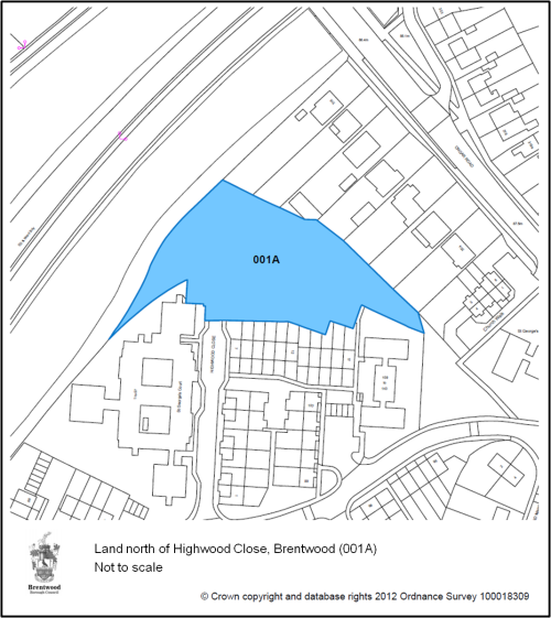
-
(20)
Wates Way Industrial
Estate, Ongar Road, Brentwood (003) – (128
dwellings)
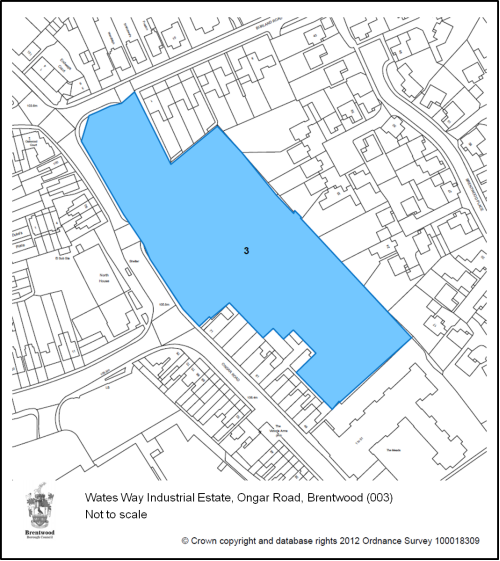
-
(4)
Essex County Fire
Brigade HQ, Rayleigh Road, Brentwood (005) – (101
dwellings)
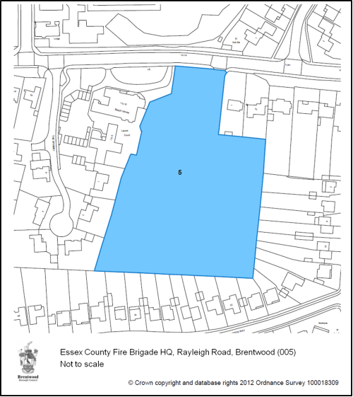
-
(4)
Land adj. Adult
Education Centre, Rayleigh Road, Hutton (006) – (11
dwellings)
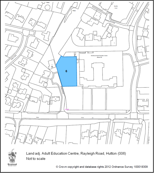
-
(6)
Land between
Tendring Court and Tillingham Bold, Woodland Avenue,
Hutton (007) – (10 dwellings)
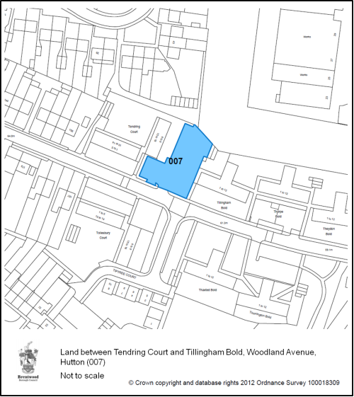
-
(91)
Land rear of 10-20
Orchard Lane, Pilgrims Hatch (011) – (19
dwellings)
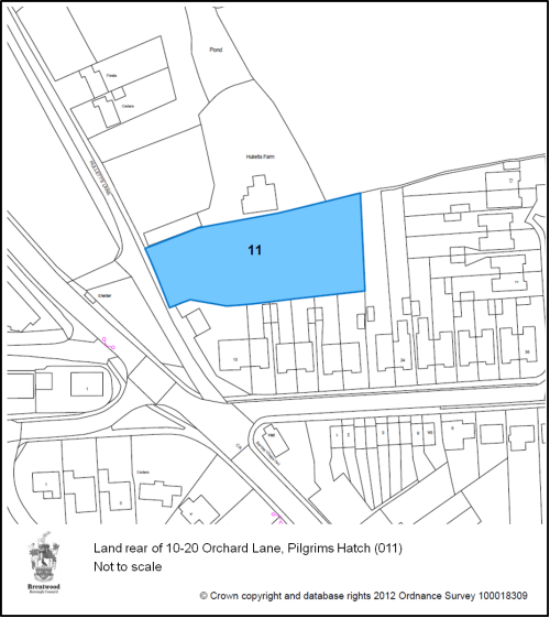
-
(7)
Garage courts adj.
49 Lavender Avenue, Pilgrims Hatch (012) – (15
dwellings)
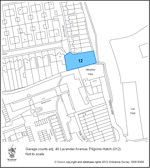
-
(1)
Warley Training
Centre, Essex Way, Warley (013B) – (53
dwellings)
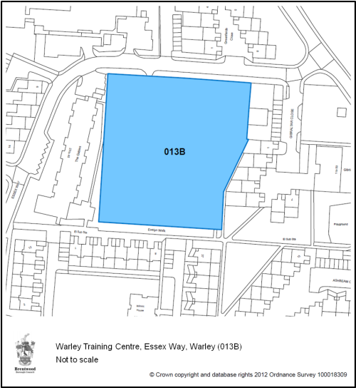
-
(2)
Westbury Road Car
Park, Westbury Road, Brentwood (039) – (22
Dwellings)
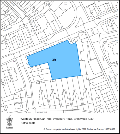
-
(2)
Chatham Way/Crown
Street Car Park, Brentwood (040) – (26
Dwellings)
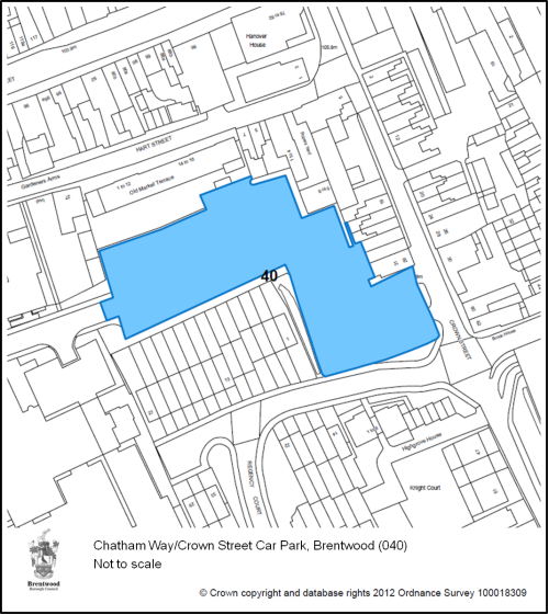
-
(3)
Land at Hunter
House, Western Road, Brentwood (041) – (22
Dwellings)
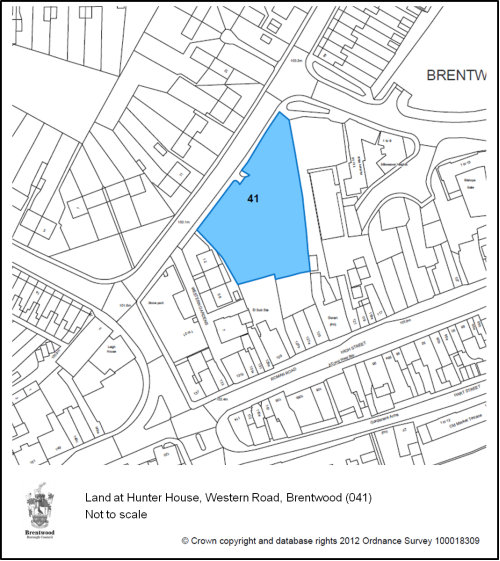
-
(1)
Garages adj. 25 King
Georges Road, Pilgrims Hatch (054) – (10
dwellings)
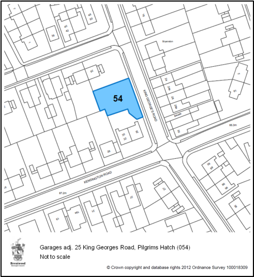
-
(3)
Council Depot, The
Drive, Warley (081) – (137 dwellings)
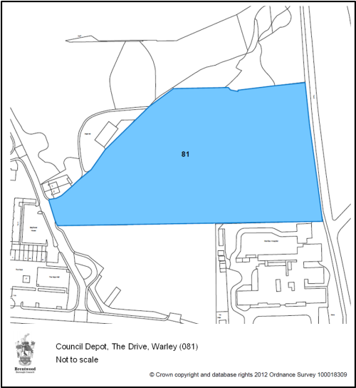
-
(2)
The Baytree Centre,
Brentwood (100) – (201 dwellings)
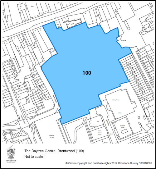
-
(1)
Land at Brookfield
Close, Hutton (131B) – (13 dwellings)
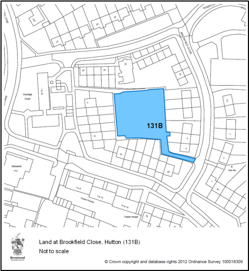
-
(1)
Land at Maple Close,
Brentwood (133) – (14 dwellings)
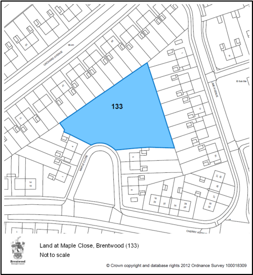
-
(7)
Woodlands, School
Road, Kelvedon Hatch (009) – (12 dwellings)
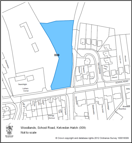
-
(45)
Land at Bell Mead,
Ingatestone (042) – (16 dwellings)
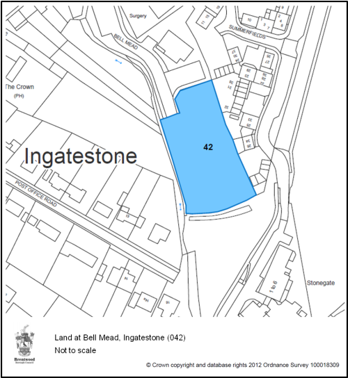
-
(9)
Former Landings
Surgery, Outings Lane, Doddinghurst (043) – (11
dwellings)
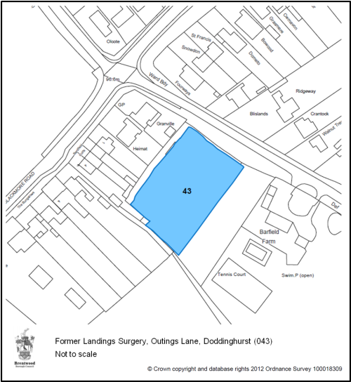
-
(20)
Sow & Grow Nursery,
Ongar Road, Pilgrims Hatch (010) – (48
dwellings)
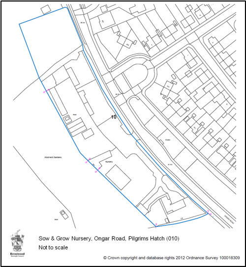
-
(57)
Ingatestone Garden
Centre, Roman Road, Ingatestone (128) – (130
dwellings)
-
(73)
West Horndon
Strategic Allocation (020, 021 & 037) – (1,500
dwellings)
Proposals for housing submitted on these allocations in accordance with the phasing indicated, will be approved where the proposed scheme is in accordance with other relevant policies of the Plan. An application for an allocation in advance of its phasing will only be approved where:
- early release would not prejudice the delivery of other allocated sites phased in an earlier time period
- the site is required now to maintain a five year supply of deliverable sites and
- infrastructure requirements of the development can be fully and satisfactorily addressed
(18) Alternative Approach
To allocate fewer sites and place more reliance on windfalls to deliver new homes.
Reason for rejection: historically, a significant number of homes have been built on windfall sites (ie previously unidentified sites) in Brentwood Borough and are expected to continue to do so in future. This approach may make it harder to manage delivery in line with the spatial strategy. There would also be less scope for windfall sites to make up for allocations which do not come forward (ie provide contingency).
Alternative Allocations
Some sites currently in other uses could be considered suitable to provide for residential use in addition to or instead of sites set out in Policy DM23. Were alternatives considered more appropriate (through further assessment) this could have potential effects on housing and economic growth over the plan period, both positive and negative. The table below sets out options.
| Site | Reasonable Alternative | Reason |
| Brentwood railway station car park (002) | Residential | Part of the existing station car park may be appropriate for residential development provided the issue of car parking is considered. Brownfield site assessed to be suitable in SHLAA. |
| Land rear of The Bull public house, Brook Street Brentwood (004) | Residential | Brownfield site assessed to be suitable in SHLAA. |
| Land at Priests Lane, Brentwood (044) | Residential with public green space | Existing protected urban open space but private land shut of from public use. Further assessment needed to look at whether this might be appropriate to provide some residential with retention of some green space for the public. |
| Former Elliot’s night club, West Horndon (048) | Employment or Residential | Brownfield site in Green Belt. |
| Land west of Warley Hill, Pastoral Way, Warley (083) | Healthcare with residential | NHS owned land that could provide expanded healthcare facilities with potential for some market housing. |
| Land at Crescent Road, Brentwood (084) | Residential with public green space | Existing protected urban open space but private land shut of from public use. Further assessment needed to look at whether this might be appropriate to provide some residential with retention of some green space for the public. |
| West Horndon opportunity area | ||
| Land East of Thorndon Avenue, West Horndon (038) | Mixed-use with residential | Alternative options may be suitable in order to provide for growth opportunities at West Horndon in line with Policy CP4. |
| Land East of West Horndon, South of Station Road (126) | Mixed-use with residential | |
| Other sites (various) | ||
| Council owned garage sites | Residential | A review of garage sites owned by Brentwood Borough Council is currently underway. The outcome of this review may suggest sites suitable for redevelopment. Most sites will be in residential areas, meaning residential redevelopment may be appropriate. |
| Council owned older persons housing (sheltered housing) sites | Provision of older persons housing with new residential | A review of Older Persons Housing in the Borough is due to take place in 2013. The outcome of this review may suggest sites could be redeveloped to make more efficient use of brownfield land to meet the needs of older people while providing additional market/affordable housing. |
Justification
4.91 The Council needs to allocate land in order to facilitate the provision of new homes in line with its proposed spatial strategy, housing figure and distribution of residential development as set out in policies S1 and S2 of this plan.
4.92 Comprehensive assessments of potential sites have been carried out by the Council, independent technical specialists and other bodies. Brentwood Strategic Housing Land Availability Assessment (SHLAA, 2010) has been the main source of potential housing sites to be considered for allocation. Sites in the SHLAA and identified subsequently are derived from various sources including:
- Sites submitted by land-owners and developers;
- Sites proposed by parish councils and members of the public; and
- Other sites known or owned by the Council.
Basis for site selection
(2) 4.93 To determine which land to allocate sites have been assessed against criteria, including (but not limited to) the following:
- ability to deliver the overall spatial strategy and vision
- whether sites are suitable for housing
- accessibility – to public transport, services and facilities
- infrastructure provision
- impact on the Green Belt, landscape, visual amenity, heritage, transport and environmental quality including wildlife, flood-risk, air and water pollution
- impact on highways
- whether the site is likely to come forward over the plan period
4.94 A Sustainability Appraisal carried out for each site, together with technical analysis and modeling, has enabled the Council to reach an informed judgment on the above and related matters. Previous unimplemented allocations have been reviewed.
Estimated Capacity
4.95 An estimate of how many dwellings each site should accommodate has been made by adopting a density and developable area based on location, area characteristics and site circumstances. This is broadly consistent with Policy DM3 (Residential Density). Site constraints eg topography and potential or desirability for mixed use are also taken into account. Site density details for each site are set out in Appendix 2.
4.96 Sites 1 through 16 as set out in Policy DM23 above are within the Brentwood urban area. This is brownfield land where it is necessary to maximise density in order to use land efficiently and reduce pressure to release greenfield sites. Sites 17 to 19 are brownfield sites in villages outside Brentwood.
4.97 Sites 20 and 21 are brownfield land in Green Belt, connected to (or very close to) urban areas. These need to provide for an appropriate level of residential density across the site to efficiently make use of allocated land. If not allocated it is likely planning permission would be granted using NPPF criteria, provided there is no greater impact on the openness of the Green Belt. This would likely result in small scale residential development using the existing building footprint. If this were the case then more Green Belt sites would be required to meet housing need, potentially greenfield Green Belt land. Allocating these brownfield Green Belt sites for larger residential provision utilises land more efficiently and provide sustainable urban extensions without use of greenfield land.
4.98 The West Horndon Strategic Allocation (site 22) is made up of three sites. These are the two existing industrial estates and adjoining greenfield Green Belt land to the north. More details are set out in Policy CP4.
Phasing
4.99 For each allocated site the Council has estimated when it is likely to come forward over the lifetime of the Plan. Delivery ultimately depends upon external factors such as finance availability house builders, mortgage availability for purchasers, and landowners’ aspirations. A housing trajectory for all site allocations is set out in Appendix 3.
Evidence
Green Belt and Landscape Sensitivity Assessment –
forthcoming
Modelling work – forthcoming
SA/SEA
SHLAA
Site assessment pro-formas – these assess each site against a
consistent and comprehensive range of criteria
Water Cycle Study & Strategic Flood Risk Assessment,
2011
National Policy
NPPF Core Principle, paragraph 17:
Allocations of land for development should prefer land of
lesser environmental value, where consistent with other
policies in this Framework; and encourage the effective use
of land by reusing land that has been previously developed
(brownfield land), provided that it is not of high
environmental value.
NPPF paragraph 47: To boost significantly the supply of housing, local planning authorities should:
- ensure that their Local Plan meets the full, objectively assessed needs for market and affordable housing in the housing market area, as far as is consistent with the policies set out in this Framework, including identifying key sites which are critical to the delivery of the housing strategy over the plan period; and
- Identify key sites which are critical to the delivery of the housing strategy over the plan period; and identify a supply of specific, developable12 sites or broad locations for growth, for years 6-10 and, where possible, for years 11-15
- for market and affordable housing, illustrate the expected rate of housing delivery through a housing trajectory for the plan period
NPPF, Paragraph 157: Local Plans should allocate sites to promote development and flexible use of land, bringing forward new land where necessary, and provide detail on form, scale, access and quantum of development where appropriate.
Target
Successful realisation of development on identified sites in line with policy.
Indicator
Permissions, Starts and Completions measured against housing trajectory
End user surveys (for major sites)
Delivery
IDP, Housebuilders, RSLs
(20) Policy DM24: Affordable Housing
In new developments comprising 15 dwellings or more, or on sites of 0.66 hectares or more in the Brentwood urban area, at least 35% of dwellings within the development shall be affordable. In developments with fewer than 15 dwellings provision should be made for:
- At least four affordable homes on sites which have 12 to 14 dwellings
- At least three affordable homes on sites of 10 or 11 dwellings
- At least two affordable homes on sites of 8 or 9 dwellings
- At least one affordable home on sites of 5 to 7 dwellings
- On sites of 1 to 4 dwellings, either provision on site or a financial contribution for each new dwelling towards the provision of affordable housing elsewhere in the Borough
The tenure of the affordable housing shall be provided in agreement with the Council and shall be provided to eligible households whose needs the Council agrees are not met by the market.
In agreement with the Council, the affordable housing will:
- Meet the needs of eligible households including availability at a cost low enough for them to afford, determined with regard to local incomes and local house prices
- Include provision for the home to remain at an affordable price for future eligible households or for the subsidy to be recycled for alternative affordable housing provision
- Promote social inclusion with affordable housing dispersed throughout the site rather than grouped in one area and designed to be indistinguishable from market housing
Where development viability is compromised, the developer must provide evidence why targets cannot be met and the Council will negotiate with the developer to establish a level of affordable housing provision that is achievable.
Alternative Approach
Alternative Policy 1: set a 35% target for housing in all new developments to be affordable regardless of location.
Reason for rejection: a blanket target may be difficult to achieve due to a lack of public funding and failure to take into account the relationship between location and viability. The preferred policy will enable a more targeted approach taking into account location and site characteristics.
Alternative Policy 2: set minimum threshold(s) below which no contribution will be sought. This could be higher in urban areas and lower in rural areas.
Reason for rejection: The Borough has a high level of housing need. Not setting minimum thresholds should ensure all new housing development makes some contribution to providing affordable housing, therefore, the preferred approach will be more effective at addressing need.
Justification
4.100 A growing number of households in the Borough cannot afford to buy or rent on the open market. House prices in Brentwood are among the highest in Essex.
4.101 The Council’s Housing team monitor purchase and rental prices. This provides a reasonable basis on which to gauge affordability on a rolling basis. Figures show that the lowest priced 3 bedroom houses available as at July 2012 range from £175,000 for second hand to £341,667 for new build. This is beyond what the majority of those who work in the Borough can afford.
4.102 For the purposes of this policy affordable housing is defined as housing that can be accessed by people who cannot afford to rent or buy on the open market and where measures are in place to retain this housing, or secure its replacement, in perpetuity.
4.103 A shortage of affordable housing leads to overcrowding, poor health, inability to achieve a decent standard of living and personal aspirations such as living independently, having children, being part of the family or social network of choice – all factors that contribute to the sustainability of neighbourhoods.
4.104 Between 2001 and 2010 19% of homes built in the Borough were affordable homes. This is less than might otherwise have been achieved were there no minimum thresholds. Requiring developers to provide some affordable housing whenever a new home is built, while recognising viability varies depending on site size and location, will increase the scope for providing affordable homes.
4.105 So that new housing contributes towards the creation of sustainable, inclusive communities, there will be a presumption that affordable housing should be provided on site. The Council recognises, however, there may be circumstances where provision off site or a contribution in lieu of provision may be acceptable.
4.106 Brentwood’s Strategic Housing Market Assessment (January 2010) highlights a role for intermediate housing in the Borough alongside social rented housing. The SHMA forecasts Brentwood’s housing requirement to 2026 as follows: 29.6% Social Rent, 65.5% Intermediate (part rent/shared ownership) and 4.9% Market. (LCB Strategic Housing Market Assessment, Figures 123, 137 and 136). Practical and policy considerations, notably limited public funds and the desirability of achieving a mix of tenures and extending choice, make provision on this scale unrealistic. There continues to be a strong demand for market housing which will need to be built in order to deliver affordable housing. Therefore the policy aims to maximise affordable housing provision, including both rented and shared equity/ownership schemes, taking into account viability and wider policy considerations. The proposed policy will be considered in light of the new SHMA findings, when available, and if necessary amended.
4.107 A study commissioned by the Council on residential site viability looked at the economics of future residential development under a range of scenarios for different size of scheme, type of site, location and economic conditions. The study recommends for sites above 15 dwellings a Borough-wide affordable housing target of at least 35%, based on a higher proportion of intermediate, rather than social rented tenures (Viability Assessment For London Commuter Belt (East)/M11 Sub Region, 2010). Viability tends to fall on smaller sites of five or more dwellings where a maximum of 30% is more achievable. The study notes that higher density development is more viable in Brentwood, compared with elsewhere in the Borough, with the optimum development density, at 35% affordable housing, in the region of 50 to 70 dwellings per hectare.
4.108 As well as meeting the housing needs of those who can neither afford to buy or rent on the open market nor qualify for social housing, providing affordable intermediate housing increases the scope for social housing to be released for others. Where intermediate rented products are priced too high, some households allocated social housing who can potentially afford alternative intermediate products if appropriately priced. The national letting database (CORE) for intermediate housing sales shows that a proportion of households who buy shared ownership can also afford open market prices. CORE also shows that a proportion of affordable housing is let to households who can afford more that social rents.
4.109 With regard to thresholds, on general development sites (15-250 dwellings) the 2010 Viability Assessment recommends a single Borough-wide affordable housing target of up to 35% on sites above 15 units on the basis that this is applied flexibly and from a realistic perspective taking into account market conditions, value areas, density and other planning and infrastructure requirements.
4.110 The assessment notes that in comparison with other local authority areas in the sub region higher density development is relatively more viable in Brentwood. Higher density developments typically incorporate a higher number of 1 and 2 bedroom units which would be consistent with the 35% policy target recommended for general development sites.
4.111 Outside the Brentwood urban area, the Viability Assessment recommends retaining the existing five unit threshold. It notes that 30% affordable housing is likely to be achievable on low density (30 dph) schemes, reducing to 20% affordable housing on schemes developed at 50-70 dph. Were any policy on sites below 15 units to be introduced in the Brentwood urban area, this should be flexible enough to ensure that sites of this size continue to come forward for residential development given that such sites have not previously been expected to provide affordable housing in this location.
Evidence
Analysis of past completions (as recorded in annual
monitoring reports and housing trajectory).
Strategic Housing Market Assessment 2010 and Update
(forthcoming - 2013)
Brentwood Allocations Policy 2007
Brentwood Annual Monitoring Report 2010/11 2011
Brentwood five year housing supply assessment 2012 to
2017, 2012
Brentwood Homelessness Strategy 2008 to 2013 2008
Brentwood Strategic Housing Land Availability
Assessment (SHLAA) 2011
CLG Housing Statistics: Dwelling Stock by Tenure and District
2011
Essex County Council – Adult Social Care Market Position
Statement 2012
Greater Essex Demographic Forecasts, Essex Planning
Officers Association 2012
Housing Strategy – forthcoming
House Price Index, Land Registry
A plain English guide to the Localism Act 2012,
Communities and Local Government
Viability Assessment For London Commuter Belt (East)/M11
Sub Region, 2010
Outline Affordability Ratios 2012 are shown in the table below:
Source: Brentwood Council 2012
In Brentwood, the average home cost £342,000 in November 2011 compared with £248,000 for Essex and £241,000 for the UK (BBC figures based on Land Registry data). With an average weekly wage of £531 this leaves an estimated ratio of house prices to estimated household income in excess of 6:1. An analysis of local house price figures show that the lowest priced three bedroom houses available as at July 2012 range from £175,000 for second hand to £341,667 for new build.
National Policy
NPPF, paragraph 47 – To boost
significantly the supply of housing, local planning
authorities should:
- use their evidence base to ensure that their Local Plan meets the full, objectively assessed needs for market and affordable housing in the housing market area, as far as is consistent with the policies set out in this Framework, including identifying key sites which are critical to the delivery of the housing strategy over the plan period
- for market and affordable housing, illustrate the expected rate of housing delivery through a housing trajectory for the plan period and set out a housing implementation strategy for the full range of housing describing how they will maintain delivery of a five-year supply of housing land to meet their housing target
NPPF, Paragraph 50: Local Planning Authorities should, where they have identified that affordable housing is needed, set policies for meeting this need on site, unless off-site provision or a financial contribution of broadly equivalent value can be robustly justified (for example to improve or make more effective use of the existing housing stock) and the agreed approach contributes to the objective of creating mixed and balanced communities. Such policies should be sufficiently flexible to take account of changing market conditions over time.
Localism Act 2011
This gives Local Authorities greater freedom to set their own policies to determine who can access the waiting list for social housing in their area. There remains a duty to ensure social housing goes to the most vulnerable in society and those who need it most. However, the legislation allows for qualification criteria to be set locally. The council can also set rents at ‘affordable’ levels at up to 80% of market rent which will influence accessibility.
Welfare Reform Act 2012
From April 2013, tenants of working age who receive Housing Benefit will have this reduced if they have one or more spare bedrooms. The reduction is expected to be 14% for one extra bedroom and 25% for two extra bedrooms or more. In addition, a Housing Benefit ‘cap’ will be introduced which limits the amount of Housing Benefit payable for accommodation with the stated intention of reducing rental levels.
The local impact of these changes is yet to be analysed fully but it is likely to have a significant effect both on under occupancy within the Council’s own housing stock and the extent to which letting to tenants in receipt of Housing Benefit within the private sector remains viable.
Target
A borough wide target of 30% of new homes to be affordable. Site specific delivery in line with policy and housing trajectory
Indicator
Regular monitoring of planning permissions, starts and completions of new housing by type and tenure of new affordable housing units built taking into account site size and location.
Delivery
Developer contributions (S106 or equivalent)
Development management decisions.
Working in partnership with community stakeholders, developers, landowners, planning applicants, Registered Social Landlords and other Affordable Housing Providers and the Homes and Communities Agency
Local Investment Plan.
BBC Housing Strategy (forthcoming)
RSLs
Housebuilders
(2) Policy DM25: Affordable rural housing
In very special circumstances the development of small scale low cost rural housing may be permitted in the Green Belt where all the following criteria are met:
- The site is within or adjacent to a settlement
- The site is accessible to a range of local services, such as shops, primary schools, healthcare and public transport
- There is a demonstrable local need within the village settlement that cannot be met another way
- Homes provided are 100% affordable unless it can be demonstrated that an element of market housing is necessary to deliver a significant amount of affordable housing
- The housing is provided for people with a strong and demonstrable local connection
- Safeguards are in place to ensure homes remain affordable in perpetuity
- The development is small-scale, does not exceed that required to meet current need and respects the character of the settlement and surrounding landscape
A person with a strong local connection should meet the following criteria:
- Existing local residents requiring separate accommodation
- Close relatives of existing local residents who have a demonstrable need to either support or be supported by them
- People whose work provides an important and necessary local service
In the context of this policy "local” means a parish or ward, or in exceptional circumstances, adjacent parishes or wards.
Alternative Approach
To have no policy on rural affordable housing but take decisions in light of national policy
Reason for rejection: a local policy will assist prospective applicants to understand the kind of schemes the Council considers acceptable.
Justification
4.112 Sometimes a need for affordable housing in a rural location exists that cannot be met on a previously developed site within an existing village boundary. Any site released under this policy would be an exception to Green Belt policies. All rural affordable housing proposals should be supported by a local housing needs survey conducted at parish or neighbourhood level. The survey should provide evidence on the number, type and size of homes needed. Preference will be given to sites with good access to local facilities and the ability to travel by non-car modes.
4.113 For rural housing the effect of higher prices on homes in rural areas is that low income households are squeezed out of the market unless there is a ring fenced supply of affordable homes. Right to buy has eroded this supply (Taylor Review of Local Economy and Affordable Housing). A characteristic of Brentwood is that it comprises distinct rural and urban communities. This effect is compounded by lower than average salaries for local workers in traditional rural industries. Retaining these households is important as benefits extend to local labour force retention, maintaining sustainable rural communities and family and community networks and providing informal care and support. Addressing these factors will be crucial for the Council to deliver its Place and Prosperity ambitions.
Evidence
Affordable Housing Viability Assessment (2010)
Brentwood Housing Strategy - forthcoming
Taylor Review of Local Economy and Affordable Housing,
CLG, 2008
Strategic Housing Market Assessment (SHMA) -
forthcoming
National Policy
NPPF paragraph 54: In rural areas,
exercising the duty to cooperate with neighbouring
authorities, local planning authorities should be responsive
to local circumstances and plan housing development to
reflect local needs, particularly for affordable housing,
including through rural exception sites where appropriate.
Local planning authorities should in particular consider
whether allowing some market housing would facilitate the
provision of significant additional affordable housing to
meet local needs.
NPPF paragraph 55 To promote sustainable development in rural areas, housing should be located where it will enhance or maintain the vitality of rural communities. Local planning authorities should avoid new isolated homes in the countryside unless there are special circumstances.
Target
Provision in line with policy
Indicator
Development Monitoring
Delivery
Development management decisions
The Council working with other bodies, eg Parish Councils, RSLs and rural enablers.
(3) Policy DM26: Specialist Housing
Proposals for specialist residential and supported accommodation will be permitted where the following criteria are met:
- the proposal has all necessary facilities close by such as shops, public transport, health and leisure facilities and, where appropriate, employment and day centres
- the proposal would not result in the over concentration of residential homes in any individual street
- evidence is provided demonstrating the suitability of the premises to meet the particular needs of the group to be housed
- where appropriate the scheme shall provide sufficient integrated accommodation to allow for the level of support required for the client group for whom the scheme is intended
- the proposal provides appropriate landscaping and amenity space
Where appropriate, a condition will be imposed restricting occupation to persons requiring supported accommodation.
Alternative Approach
1. To have no policy on specialist housing
Reason for rejection: Although there is now more emphasis placed on supporting people in their homes than previously there continues to be a need for specialist accommodation to address the needs of the growing number of frail elderly people and other groups requiring supported accommodation whose needs are not met by mainstream housing.
2. To cover the issue within another policy, eg affordable housing or a housing mix policy
Reason for rejection: Specialist housing can be market or affordable housing – both types exist and are likely to be needed in future.
Justification
4.114 This policy is intended to support the provision of specialist accommodation in the Borough. Reflecting national trends, the Borough’s population is ageing. Just under a fifth of the population is over 65 and more than a quarter of households contain someone of this age – these proportions are projected to increase. There appears to be a general desire among older people to remain in their own home for as long as possible. Part of the response to an ageing population is to provide choice so that should people wish to move they can find somewhere which suits their needs and aspirations. Older people generally remain fit and active longer than they did in the past, however, particular types of accommodation and support will be required in order to meet the needs of a growing number of frail elderly people. Other groups with specific needs also require specialist accommodation. Providing a greater range of housing within the Borough will assist more people to continue living locally and free up housing for others.
4.115 With regard to supported housing, the Strategic Housing Market Assessment notes that the Borough has a small oversupply at present but that “supply is in line with need by 2025”. The SHMA also notes that much of this supply (in Brentwood and other areas) fails to meet the decent homes standard or DDA/equality compliance regulations.
4.116 It is important to ensure that people living in residential homes and other specialist accommodation are part of the community where they live and have access to facilities, like shops, healthcare and public transport. At the same time, it is best to avoid having too many specialist residential schemes in one street since this may adversely affect the balance of the community and put pressure on local services. In determining whether there is a need for a particular type of specialist housing the Council will have regard to up to date information on local need and provision, such as that collated by the County Council, local health practitioners and the findings of the new SHMA due later in 2013.
Evidence
2011 Census
Brentwood Older Person’s Housing Strategy
(forthcoming)
CLG Household Projections
County Council
Ongoing work in relation to the Health and Wellbeing agenda
(NHS Commissioning Partnerships).
ONS 2010 based sub-national population projections
SHMA – 2010 and forthcoming update.
Consultation Feedback
Consultation responses highlight the importance of
considering the needs of older people, especially with regard
to provision of housing, services and public transport.
National Policy
The NPPF, paragraph 50 requires local authorities to plan to
meet the needs of different groups, including older people
and those with disabilities and “create sustainable,
inclusive and mixed communities.”
NPPF, Paragraph 171: Local planning authorities should work with public health leads and health organisations to understand and take account of the health status and needs of the local population.
Target
Provision in line with policy
Indicator
Development monitoring
Delivery
Development management decisions.
(2) Policy DM27: Mixed Use Development
Major development proposals within Brentwood town centre, Borough district centres at Shenfield Hutton Road, Ingatestone High Street and Warley Hill Brentwood station area, as defined on Policies Map, will be required to provide an appropriate mix of uses. Proposed development should:
- contain an appropriate mix of ground floor uses such as A1, A2, A3, A4, A5 of Use Classes Order 1987 (as amended) with active street frontages and complimented by B1 and D1 where appropriate
- ensure main pedestrian entrances enable access to all accommodation from public space
- demonstrate potential commercial related problems, such as noise and smell, will be overcome satisfactorily to protect amenities of surrounding residents (existing and proposed)
Mixed use development will be sought except where:
- proposed development makes efficient use of the site, is considered to be of sufficient density and has active street frontages that make a multiple use impractical or undesirable
- access to more than one use is physically impossible
- overall balance of uses in the immediate area or street is considered sufficient to ensure economic variety and diversity
Planning permission will not be granted for change of use which results in an unacceptable mix of uses or the loss of a use that will have the same effect.
Alternative Approach
1. To have no mixed use policy and assume mixed use schemes are proposed regardless.
Reason for rejection: Without a policy it is more likely that single use schemes would come forward. This would make harder to sustain a good balance of uses. Over time the sustainability and vibrancy of areas may suffer as a consequence.
2. To have a policy setting out the mix for each site.
Reason for rejection: While this may be done for some sites, it would be impractical for all of them.
Justification
4.117 The benefits of mixed use are widely recognised. Locating a variety of land uses close together, such as retail, employment, leisure and residential, contributes to the vitality and vibrancy of centres, reduces the need to travel and enhances community safety. Improving links between homes, businesses, local shops, community and leisure facilities can bring jobs and essential services closer to where people live and vice versa. As well as being more convenient, mixed use can deliver local economic benefits.
4.118 The nature of mixed-use development varies depending on location. The variety of uses increase and physical distribution of uses becomes more concentrated closer to Brentwood town centre. This is also true to a lesser extent in the Borough’s district shopping centres. In these areas the mix of uses will be assessed at a local level within a street or locality. In Brentwood town centre the mix of uses will be addressed on individual sites. In all cases, successful mixed-use development depends on the complementary nature of uses within the development itself and its immediate surroundings. Residential development can also give rise to demand for additional community facilities. For example, a community hall, medical facilities, education or local shopping provision may be required, or improvements to existing provision made, to meet the needs of new and existing residents.
4.119 For the purposes of this policy, definitions of major development as set out in DCLG statistical returns are used, such as 10 net residential units and above, 1,000 sqm of floorspace (of whatever use), or sites in excess of 1 ha.
National Policy
NPPF Core Principle, paragraph 17:
Planning should promote mixed use developments, and
encourage multiple benefits from the use of land in urban and
rural areas, recognising that some open land can perform many
functions (such as for wildlife, recreation, flood risk
mitigation, carbon storage, or food production).”
NPPF paragraph 37: Planning policies should aim for a balance of land uses within their area so that people can be encouraged to minimise journey lengths for employment, shopping, leisure, education and other activities.
NPPF paragraph 38: For larger scale residential developments in particular, planning policies should promote a mix of uses in order to provide opportunities to undertake day-to-day activities including work on site.
Target
Appropriate mix of uses within Borough’s main centres providing homes, jobs and local needs
Vital and viable urban areas performing well
Indicator
Development Monitoring
Town Centre Health Checks
Development Monitoring Delivery
Pre-application discussion and Development Management
(147) Policy DM28: Gypsy and Traveller Provision
Provision will be made within the Borough to meet the need for 44 permanent Gypsy and Traveller Pitches to 2030.
The Council will identify Gypsy and Traveller sites to meet this provision, through a combination of allocations to ensure a five year land supply is maintained throughout the plan period, and the grant of planning permissions in accordance with the following criteria:
- The site does not give rise to unacceptable harm to the Green Belt
- The site is well related to existing communities and accessible to local services and facilities, such as shops, primary and secondary schools, healthcare and public transport
- The site is serviced by a suitable access road
- The location would not result in unacceptable living conditions for its occupants
- The proposed accommodation would not harm the character and/or appearance of the area and/or result in unacceptable visual impact
- The site is located, designed and landscaped to minimise any impact on the environment
The Council proposes to allocate the following five sites to provide for 20 pitches to be distributed as follows:
| Site | Address | Number of pitches |
| Deep Dell Park (Willow Farm) | Stock Road, Ingatestone |
|
| Hope Farm | Horsemanside, Navestock |
|
| Rye Etch | Mill Lane, Navestock |
|
| Tree Tops | Curtis Mill Lane, Navestock |
|
| Roman Triangle | Roman Rd, Mountnessing |
|
West Horndon is identified as a broad location for further provision to be planned as an integrated way as part of a mixed use development (See West Horndon Core Policy). The level of provision is subject to the findings of the forthcoming GTAA but in the first instance estimated to be 14 pitches.
Alternative Approach
To allocate 15 years' worth of pitches at the start of the plan period.
Reason for rejection: This approach may be difficult to achieve in practice given the Borough's lack of suitable locations for traveller site. A combination of site allocations and identifying a broad location is considered a pragmatic approach that will provide for the needs of Gypsies and Travellers over the plan period.
Justification
(1) 4.120 The Borough Council has a duty to identify land to meet the local needs of Gypsies and Travellers. Around 80 per cent of land in Brentwood lies within Green Belt where development is strictly controlled. Elsewhere, there is a lack of available land within the built up area. This limits options available for providing new pitches in suitable locations.
4.121 The preferred approach aims to ensure that the target for pitch provision will be met throughout the plan period through allocations, maintaining a five year land supply and identifying a broad location for further provision.
(1) 4.122 The proposed target is based initially on the former East of England Plan revised figure but in the next iteration of this plan the intention is to set a new target and plan provision, derived from an updated needs assessment. The East of England Plan required the Borough to provide an additional 24 pitches between 2006 and 2021 bringing the total number of permanent authorised pitches in the Borough to 34.
(1) 4.123 As of July 2013 authorised sites within the Borough provide for an estimated 30 pitches, two thirds of these pitches on sites with temporary permission; 10 on sites with permanent permission. There remains a need for an additional 24 pitches with permanent permission up to 2021 and a further 10 pitches up to 2030, bringing the total number of pitches to 44.The level of provision is calculated by applying a 3% annual compound increase as recommended by the former regional plan.
(1) 4.124 To meet needs over the plan period the policy proposes in the first instance to allocate for permanent use a number of existing temporary sites and secondly to guide future provision through identifying a broad location. The latter is intended to address remaining needs for the plan period. The scale of this allocation will be informed by an updated assessment, currently underway, which will in turn inform an updated target. Generic criteria are proposed for considering future planning applications and allocations.
(1) 4.125 It should be noted that while there was a later GTAA in 2009, this was not subject to rigorous testing through examination as was the previous GTAA which informed regional policy. It is therefore considered less robust and has not been used as a basis for calculating future provision.
Evidence
Annual Monitoring Report, 2011-12
Brentwood Gypsy and Traveller Accommodation Needs
Assessment (forthcoming).
CLG bi-annual caravan count
East of England Plan revised policy H3 (now
revoked)
Essex GTAA, Fordham 2009.
| Former District Pitch Requirements set out in RSS Policy H3 and Essex GTAA 2009 | |||||||||||
|---|---|---|---|---|---|---|---|---|---|---|---|
| Policy H3 | Essex GTAA | ||||||||||
| Authorised Pitches in 2006 | Additional Pitches 2006-2011 | Minimum Pitches 2011 | Additional Pitches 2011-2021 | Minimum Pitches at 2021 | Total Requirement 2006-2021 | Total at 2008 | Requirement 2008-2013 | Total Pitches 2013 | Requirement 2013-2021 | Total Pitches 2021 | Total Requirement 2008-2021 |
|
|
|
|
|
|
|
|
|
|
|
|
|
National Policy
Planning Policy for Traveller
Sites, Paragraph 3:The
Government’s overarching aim is to ensure fair and equal
treatment for travellers, in a way that facilitates the
traditional and nomadic way of life of travellers while
respecting the interests of the settled community.
Planning Policy for Traveller Sites, Paragraph 8: Local planning authorities should set pitch targets for gypsies and travellers and plot targets for travelling showpeople which address the likely permanent and transit site accommodation needs of travellers in their area, working collaboratively with neighbouring local planning authorities.
Planning Policy for Traveller Sites, Paragraph 9: Local planning authorities should, in producing their Local Plan:
- identify and update annually a supply of deliverable sites sufficient for five years’ worth of sites against locally set targets
- identify a supply of specific, developable sites or broad locations for growth, for years six to ten and, where possible, for years 11-15
- consider producing joint development plans that set targets on a cross-authority basis, to provide more flexibility in identifying sites, particularly if a local planning authority has special or strict planning constraints across its area (local planning authorities have a duty to cooperate on planning issues that cross administrative boundaries)
- relate the number of pitches or plots to the circumstances of the specific size and location of the site and the surrounding population’s size and density
- protect local amenity and environment
Planning Policy for Traveller Sites, Paragraph 10: Criteria should be set to guide land allocations where there is identified need. Where there is no identified need, criteria-based policies should provide a basis for decisions in case applications nevertheless come forward. Criteria based policies should be fair and facilitate the traditional and nomadic life of travellers while respecting the interests of the settled community.
Target
To achieve a total 44 permanent pitches in the Borough between 2015 and 2030 or such figure as agreed by the Council following an up-to-date needs assessment.
To maintain a five year supply of pitches throughout the plan period
Indicator
CLG bi-annual caravan count
Monitoring planning permissions
Delivery
Development management decisions
(7) Policy DM29: Accessible, Adaptable Development
All development should deliver an inclusive, accessible environment throughout. Housing development should meet Lifetime Homes Standard with a minimum of 5% of new dwellings on developments of 20 dwellings or more built to full wheelchair standards.
Development proposals should be accompanied by a design and access statement setting out how the principles of inclusive design, and adaptability, including the specific needs of disabled people, have been integrated into the proposed development.
Alternative Approach
No alternative policy has been identified. The Council considers the policy to be essential in order to deliver sustainable development
Justification
4.126 Flexible, adaptable and with convenient features, Lifetime Homes are designed to meet the changing needs of different occupiers at different stages of their lives. Lifetime Homes enable elderly people to stay in their home for longer, are convenient for parents with small children and provide better access for disabled people than mainstream housing. Given that the Borough’s population is ageing and the vast majority of existing housing comprises mainly older, inaccessible properties we must ensure all new homes are accessible with a proportion of new homes built to full wheelchair standard.
Evidence
Essex County Council Older Person's Housing Strategy
(2007)
Housing Stock Condition Survey 2004
Lifetime Homes Standards – Initially developed by the Joseph
Rowntree Foundation and Habinteg Housing Association the
standards were updated in 2010 by The Foundation for Lifetime
Homes and Neighbourhoods (comprising Age UK, TCPA, and
Habinteg) see www.lifetimehomes.org.uk
Updated SHMA (forthcoming).
National Policy
NPPF paragraph 50: To deliver a wide
choice of high quality homes, widen opportunities for home
ownership and create sustainable, inclusive and mixed
communities, local planning authorities should:
- plan for a mix of housing based on current and future demographic trends, market trends and the needs of different groups in the community (such as, but not limited to, families with children, older people, people with disabilities, service families and people wishing to build their own homes);
- identify the size, type, tenure and range of housing that is required in particular locations, reflecting local demand;
NPPF Glossary, page 54: Older people's housing needs “can encompass accessible, adaptable general needs housing for those looking to downsize from family housing and the full range of retirement and specialised housing for those with support or care needs.”
Target
To increase the number of homes and other properties in the Borough that meet accessibility standards.
Indicator
Monitoring policy usage
Delivery
Development Management Decisions
Quality of Life & Community Infrastructure
4.127 This section of the Plan deals with the provision of community infrastructure and measures necessary to ensure that new development is delivered sustainably in accordance with the Plan’s Vision, Strategic Objectives and Core Policies, without harm to visual and residential amenity, or the wider environment.
Strategic Objective 9
Protect and nurture existing leisure, cultural and recreational assets such as the Borough’s Country Parks for residents and visitors to the Borough and promote and enhance social inclusion, health and well being.
Strategic Objective 10
Improve public transport, cycling and walking facilities and encourage sustainable transport choices.
Strategic Objective 11
Secure the delivery of essential infrastructure, including transportation schemes and community facilities in order to support new development growth throughout its delivery
(6) Policy DM30: Provision of Open Space in New Development
New development proposals are expected to provide functional on-site open space and/or recreational amenities or where appropriate, financial contributions towards new or improved facilities nearby. The amount and type of provision required will be determined according to the size, nature and location of the proposal; quantity and type of open space needed; and existing provision accessible to the proposal. All payments will be in line with the Council’s Core Policy CP17 Provision of Infrastructure and Community Facilities.
A commuted sum will only be accepted for:
- proposals where strategic open space requirements cannot be met within the site
- local and strategic open space in developments of single person households or of dwellings for the elderly (where however some compensating increase in private amenity space may be required)
- a town centre location within Brentwood or where it is justified by an outstanding urban design approach based on site constraints and opportunities
All open space provision should be fully equipped to meet the needs of users as agreed by the Borough Council, reflecting acceptable distance and minimum size criteria for different types of open space as set out in the Council’s Open Space Standards (Set out in paragraphs 4.140 and 4.141 below). Maintenance Plans should be submitted at planning application stage for all new facilities provided for exercise or recreation purposes. This is to secure quality over the long term and clarify responsibilities from the outset.
Alternative Approach
To combine this policy with DM31 Protection and Enhancement of Open Space, Community, Sport and Recreational Facilities.
Reason for rejection: Provision of open space in new development is an important issue in its own right. A detailed policy is needed to set out requirements expected of new developments regarding the provision of open space.
Justification
(1) 4.128 Access to good quality open space is essential for health and well-being. Residents’ ability to access local open space across the Borough varies. Brentwood Open Space, Sport and Recreational Facilities Assessment (2007) identifies a lack in provision in some areas for certain types of open space. Provision with new development is therefore particularly important in areas where a deficiency has been identified or where new development would give rise to a deficiency.
4.129 The proportion of any site to be set aside (or the contribution to be made for off-site provision) will be assessed with regard to the extent, nature, quality and accessibility of existing provision, the suitability of the site and form of the proposed development.
4.130 On larger residential and/or commercial schemes of 50 units and above, the Council will seek at least 15% of the site to be set aside for public open space. Developments providing specialised accommodation for the elderly, such as sheltered housing, will only require the provision of private amenity space as part of the site.
4.131 In some central urban locations site constraints may make new provision difficult, in which case a contribution towards providing or enhancing open space facilities nearby may be acceptable. Open space should, however, form an integral part of large scale redevelopment proposals.
4.132 The Council will require a contribution towards the laying out, provision and future maintenance of play equipment, where open space is provided as part of the overall development. An Infrastructure Delivery Plan and CiL Charging Schedule, under preparation, will provide further detail on arrangements for securing commuted payments and ongoing maintenance through planning obligations, in line with Core Policy CP17 Provision of Infrastructure and Community Facilities.
Evidence
Brentwood Open Space Strategy 2008-2018
Brentwood Play Area Strategy 2007-2010 – New Strategy
anticipated Autumn 2013
Survey and Assessment of Needs and Audit of Open Space,
Sport and Recreation Facilities in Brentwood Borough
(PMP, 2007)
National Policy
NPPF paragraph 57:
it is important to plan positively for the achievement of
high quality and inclusive design for all development,
including buildings, public and private spaces and wider area
development schemes.
NPPF paragraph 69: The planning system can play an important role in facilitating social interaction and creating healthy, inclusive communities. Planning policies and decisions, in turn, should aim to achieve places which promote:
- opportunities for meetings between members of the community who might not otherwise come into contact with each other
- safe and accessible environments where crime and disorder, and the fear of crime, do not undermine quality of life or community cohesion, and
- safe and accessible developments, containing clear and legible pedestrian routes, and high quality public space, which encourage the active and continual use of public areas.
NPPF paragraph 73: access to high quality open spaces and opportunities for sport and recreation can make an important contribution to the health and well-being of communities. Planning policies should be based on robust, up-to-date assessments of the needs for open space, sports and recreation facilities and opportunities for new provision.
Target
In larger residential or commercial schemes 15% of site set aside for public open space.
Qualitative and Quantitative improvement in provision in areas of deficiency, maintain or enhance quality of provision elsewhere
Indicator
Amount and type of open space provided in the Borough relative to guidelines/requirements set out in Open Space Standards (Paragraphs 4.39 and 4.40).
Open space provision in major development
Delivery
Pre-application discussions
Development Management decisions
Infrastructure Delivery Plan
CiL / Developer Contributions
(75) Policy DM31: Protection and Enhancement of Open Space, Community, Sport and Recreational Facilities
Within the built up areas of Brentwood Borough, permission will not be granted for development of land allocated on the Policies Map as protected Open Space, Local Green Space or other previously undeveloped land, unless it can be demonstrated:
- that alternative and improved provision can be created in a location well related to the functional requirements of the relocated use and existing and future users
- the proposal would relate to the enhancement of the open space, contributing to both the character and amenity of the area
- the provision of new open space creates no additional displacement within the Green Belt
All proposals including the designation of new Local Green Space and landscaping must be accompanied by a maintenance plan to ensure long-term quality and scheme viability.
There will be a presumption against any development that involves the loss of open space, community, sport, recreation or play facilities, including allotments, except where it can be demonstrated that there is an excess of provision, or where alternative facilities of equal or better quality and convenience will be provided as part of the development.
Where appropriate, the Council will seek provision of community and recreational facilities through the acquisition of land, joint use of existing facilities or by entering into negotiation with private landowners.
(1) Alternative Approach
No alternative has been identified.
Justification
4.133 Brentwood’s existing sport, leisure, public and private open spaces, including allotments, within the Borough, are important, valued assets serving communities in which they are located and visitors. This is reflected in the strategic objective SO9 Protect and nurture existing leisure, cultural and recreational assets. This policy is concerned with ensuring good provision of high quality, accessible open space to meet the needs of the local community.
(1) 4.134 Set entirely within the Metropolitan Green Belt, Brentwood has direct access, via the rights of way network, to extensive open areas for informal recreation. Country Parks including Hutton, South Weald and Thorndon provide 324 hectares of informal open space, together with other publicly accessible playing fields, parks, woodlands and wider sporting facilities. The Council aims to retain and enhance existing facilities unless a case can be made for alternative provision to be provided which is equivalent or better in terms of the type of open space, accessibility, quality and convenience.
(1) 4.135 Brentwood Open Space, Sport and Recreational Facilities Assessment (2007) assesses provision and needs and identifies potential for enhancement, new provision and access to public open spaces such as: parks, play provision for children, allotments and natural and semi-natural green spaces. Borough wide provision is generally good, however, the assessment identifies gaps in provision for some open space types at a more local level.
4.136 With regard to accessible natural greenspace, Borough residents are generally well served. Areas less well served include the northeast of Ingatestone, parts of Hutton Mount, the west of Brentwood and Doddinghurst.
4.137 Brentwood Open Space Strategy identifies a strong provision of formal open space within the Borough, in particular in Pilgrims Hatch, Warley, Hutton North, Ingatestone and Fryerning areas. The study notes there is under provision in central Brentwood, Hutton Mount and Hutton Ward.
(1) 4.138 For outdoor sports, Brentwood is well provided for with all residents being within a fifteen minute drive (6 km) of a sports facility. However despite this reasonable provision of outdoor sports facilities, according to Essex Joint Strategic Needs Assessment (2012) only one in five Brentwood Borough adults is doing enough physical activity to benefit their health and just over one out of five adults in the Borough are obese. This highlights the importance of providing facilities that are attractive, accessible and convenient and effective maintenance plans for the long term.
(1) 4.139 Brentwood Open Space, Sport and Recreational Facilities Assessment (2007) identifies an inadequate provision of children’s play space across the Borough, which falls below the local recommended standard, at 0.08 ha per 1,000 population. Provision of new children’s play spaces will be encouraged particularly within the residential areas of Ingrave, Ingatestone, Pilgrim’s Hatch, Doddinghurst, central Shenfield and Hutton Mount.
(2) 4.140 All proposals, where appropriate, will be required to comply with the Council’s open space standards. These take account of recommendations in Brentwood Survey and Assessment of Needs and Audit of Open Space, Sport and Recreation Facilities (2007), Brentwood Open Space Strategy (2008-2018) and Children’s Play Strategy (2010). Standards are as follows:
- Outdoor Sport – 3.15 ha (per 1000 population)
- Children’s Playing Space – Between 0.13 – 0.17 ha per 1000 population
- Allotments and Community Gardens – 0.18 per ha per 1000 population
4.141 With regard to Children’s Play Space, the Council will seek proposals which meet the Fields in Trust (formerly National Playing Fields Association) minimum standards as follows:
Local Area for Play (LAP)
- Characteristics: Small, low-key games area
- LAP area: Walking Distance (100m) / Minimum Size (100 sqm)
Local Equipped Area for Play (LEAP)
- Characteristics: Five types of play equipment and a small games area
- LEAP area: Walking Distance (400m) / Minimum Size (400 sqm)
Neighbourhood Equipped Area for Play (NEAP)
- Characteristics: Eight types of play equipment with opportunities for ball games or wheeled activities
- NEAP area: Walking Distance (100m) / Minimum Size (1000 sqm)
4.142 The creation of new LEAPs will be prioritised at the Newham Estate, in line with the Borough’s Play Area Strategy.
Evidence
Analysis of Accessible Natural Greenspace Provision for
Essex, Natural England, Essex Wildlife Trust, 2009
Brentwood Open Space Strategy 2008-2018
Brentwood Play Area Strategy 2007-2010
Brentwood Local Wildlife Sites Review, Essex Wildlife
Trust, 2012
Mid Essex Landscape Character Assessment 2006
Survey and Assessment of Needs and Audit of Open Space,
Sport and Recreation Facilities in Brentwood Borough,
PMP, 2007
National Policy
NPPF paragraph 73: Access to high quality open spaces and
opportunities for sport and recreation can make an important
contribution to the health and well-being of communities.
Planning policies should be based on robust, up-to-date
assessments of the need for open space, sports and recreation
facilities and opportunities for new provision. Assessments
should identify specific needs and quantitative or
qualitative deficits or surpluses of open space, sports and
recreational facilities in the local area. Information gained
should be used to determine what open space, sports and
recreational provision are required.
NPPF paragraph 74: existing open space, sports and recreational buildings and land, including playing fields, should not be built on unless an assessment has been undertaken which has clearly shown the open space, buildings or land to be surplus to requirements; or the loss resulting from the proposed development would be replaced by equivalent or better provision in terms of quantity and quality in a suitable location; or the development is for alternative sports and recreational provision, the needs for which clearly outweigh the loss.
NPPF paragraph 76: local communities through local plans should be able to identify for special protection green areas of particular importance to them. By designating land as Local Green Space local communities will be able to rule out new development other than in very special circumstances. Identifying land as Local Green Space should therefore be consistent with the local planning of sustainable development and complement investment in sufficient homes, jobs and other essential services. Local Green Spaces should be capable of enduring beyond the end of the plan period.
NPPF paragraph 77: the Local Green Space designation should only be used where the green space is in reasonably close proximity to the community it serves; where the green area is demonstrably special to a local community and holds a particular local significance, for example because of its beauty, historic significance, recreational value (including as a playing field), tranquillity or richness of its wildlife; and where the green area concerned is local in character and is not an extensive tract of land.
Target
Maintain local community facilities and secure equal or better facilities, in terms of quality and convenience, where proposals result in the loss of existing facilities
Maximise the provision of accessible good quality open space
No net loss of open space
Indicator
Number of permissions for redevelopment or change of use resulting in the loss of existing local community facilities.
% of eligible open spaces managed to Green Flag award Standard
Delivery
Development management decisions
Brentwood Countryside Management Service and Essex County Council Country Parks Service
CIL - Private sector financial contributions
IDP - Delivery in line with open space standards
Designate new Local Green Space
(4) Policy DM32: Provision of Green Infrastructure
Development should adopt an integrated approach towards the provision of green infrastructure which enhances the Borough’s network of multi functional green space including open space, sport, recreational and play opportunities, flood storage, green roofs, habitat creation, footpaths, bridleways and cycleways, food growing and climate change mitigation.
New development will be expected to contribute to the Borough’s green infrastructure and where possible enhance and protect the existing network of green links, open spaces and sports facilities, and secure additional provision where deficiencies are identified.
Alternative policy approach
Combine this policy with DM31 Protection and Enhancement of Open Space, Community, Sport and Recreational Facilities.
Reason for rejection: Protection and Enhancement of Open Space, Community, Sport and Recreational Facilities and Provision of Green Infrastructure are considered important issues in their own right. Therefore it makes sense to include separate policies in the Plan.
Justification
4.143 ‘Green infrastructure’ is a term that refers to the network of multi-functional green space, urban and rural, which is capable of delivering a wide range of environmental and quality of life benefits for local communities.
4.144 The Borough has numerous wildlife sites, open spaces and outdoor recreational facilities. Appropriate access to, and linkages between, these assets need to be maximised. Formal and informal open space provision varies between areas and the quality and accessibility of green spaces differs. There is a need to better link these to improve their wider use and value. Existing green infrastructure should be protected and enhanced and where opportunities arise, eg in conjunction with new development, additional provision made.
4.145 It is vital that the right infrastructure is in place to support future growth in the Borough, and this includes green infrastructure. There is a growing and compelling body of evidence substantiating the potential for green infrastructure to contribute to the economic, social and environmental well being of individuals and society. It can help facilitate high quality accessible landscapes, and bring the natural world into every neighbourhood, providing benefits for individuals, community health and wellbeing.
4.146 Brentwood Health and Wellbeing Board works to promote the health and wellbeing of Brentwood’s communities. As such the Policy will focus on protecting, and improving access to, outdoor sports and recreational facilities and accessible greenspace along with the provision of new facilities where needed.
4.147 It is widely acknowledged that green infrastructure and open space has a major role to play in mitigating against and adapting to climate change, for example, urban cooling, encouraging sustainable travel choices and flood alleviation. Through the provision of green corridors the policy can help overcome habitat fragmentation and improve the ability of the natural environment to adapt to climate change and habitat loss by improving ecological connectivity.
(1) 4.148 The Council will promote local food growing by encouraging development proposals to include spaces for residents to grow their own food, safeguarding allotments and encouraging community gardens for food growing. Promoting local food growing in the Borough will have many benefits for residents. It will reduce the carbon footprint of food production by minimising CO2 emissions from transporting food and be beneficial for air quality by helping to reduce pollution. It supports healthy living by enabling residents make more sustainable food choices, protects local ecosystems and fosters community spirit and enterprise. The wider benefits of growing produce are identified in Brentwood Open Space, Sport and Recreational Facilities Assessment (2007) which highlights that providing opportunities for people to grow their own food contributes to sustainability, health and social inclusion.
Evidence
Brentwood Open Space Strategy 2008-2018
Brentwood Play Area Strategy 2007-2010 and Updated
Strategy (forthcoming)
Essex Local Wildlife Sites Review 2012
Essex Joint Strategic Needs Assessment, August,
2012
Mid Essex Landscape Character Assessment 2006
The Natural Choice: Securing the Value of Nature - The
Natural Environment White Paper, HM Government, 2011
Planning for a Healthy Environment – Good Practice
Guidance for Green Infrastructure and Biodiversity, Town
and County Planning Association and the Wildlife Trusts, July
2012
Survey and Assessment of Needs and Audit of Open Space,
Sport and Recreation Facilities in Brentwood Borough,
PMP, 2007
National Policy
The Natural Choice: Securing the Value of Nature - The
Natural Environment White Paper (HM Government, 2011)
identifies green infrastructure as the living network of
green spaces, water and other environmental features in both
urban and rural areas. Green infrastructure provides the
critical ecological links between town and country. It should
be recognised as an essential asset in developing
communities, is an effective tool in managing environmental
risks and provides diverse benefits for people and wildlife.
NPPF paragraph 17 Core Principle: Planning should promote mixed use developments, and encourage multiple benefits from the use of land in urban and rural areas, recognising that some open land can perform many functions (such as for wildlife, recreation, flood risk mitigation, carbon storage, or food production).
NPPF paragraph 99: Local Plans should take account of climate change over the longer term, including factors such as flood risk, coastal change, water supply and changes to biodiversity and landscape. New development should be planned to avoid increased vulnerability to the range of impacts arising from climate change. When new development is brought forward in areas which are vulnerable, care should be taken to ensure that risks can be managed through suitable adaptation measures, including through the planning of green infrastructure.
NPPF paragraph 114 local planning authorities should set out a strategic approach in their Local Plans, planning positively for the creation, protection, enhancement and management of networks of biodiversity and green infrastructure.
Target
Maintenance of open space safeguarded through Allocations and Development Management policies
Indicator
Additional open space provided through new development
Additions and losses to the Green Infrastructure Network, measured by area
Amount of developer contributions used to support green infrastructure
Public open spaces and Rights of Way lost, improved and created
Number of parks eligible for Green Flag award
SUDS developed
Delivery
Development Management decisions based on this policy
Site Allocations in this Plan will be used to promote areas and development sites where the Council will expect elements of green infrastructure to be established or maintained.
CIL and Infrastructure Delivery Plan
Working with others such as Essex Wildlife Trust and Local Nature Partnership
(1) Policy DM33: Air Quality
The Borough Council will promote measures to improve air quality, particularly within designated Air Quality Management Areas and will expect development proposals to reduce sources of air pollution. Where the Borough Council considers that air quality objectives are likely to be prejudiced or proposals fall within an Air Quality Management Area, applicants will be required to submit a detailed air quality assessment which sets out the impact the proposed development would have upon air quality. Planning permission will not be granted for development where there is likely to be a significant adverse impact on air quality.
Air Quality Management Areas are shown on the Policies Map.
Alternative Approach
No alternative has been identified to this policy.
National policy requires planning to contribute towards preventing unacceptable levels of air pollution and planning policies to be compliant with EU and national objectives for pollutants and take into account local Air Quality Management Areas. Therefore in order to comply with national policy it is considered necessary to require air quality assessments and refuse planning permission for development proposals which would have a detrimental impact on local air quality. This will help to meet air quality objectives and improve air quality.
Justification
4.149 All types of air pollution have the potential to harm the natural environment and human health. The Borough Council has a responsibility for monitoring air quality within their area and where air pollution exceeds national standards, can designate Air Quality Management Areas (AQMA). When an AQMA is designated, the Borough Council will produce an Air Quality Action Plan, which sets out what the Borough Council intends to do about poor air quality. Within Brentwood Borough, there are problems with air pollution, particularly transport generated emissions. There are currently seven AQMAs.
4.150 The Borough Council will seek to ensure that new development, particularly commercial, industrial and traffic generating uses do not result in unacceptable levels of air pollution. Developers should arrange pre-application discussions with the Borough Council Planning Services to ensure that air quality issues will be addressed when designing their proposals.
4.151 The Council promotes the use of renewable energy technologies to help tackle climate change, as set out in policy CP14 Sustainable Construction and Energy. Where biomass or CHP is proposed, the Council will require an emissions assessment prior to submission of a planning application. The emissions assessment must demonstrate that the plant would not significantly contribute to the deterioration of local air quality. The assessment must also demonstrate that other forms of renewable technology have been compared and assessed for their impact on local air quality.
Evidence
Air Quality Action Plan, Brentwood Borough Council,
2008
Regular reviews and assessments of air quality against
standards and objectives in the National Air Quality Strategy
National Policy
NPPF paragraph 109: The planning system
should contribute to and enhance the natural and local
environment by preventing both new and existing development
from contributing to or being put at unacceptable risk from,
or being adversely affected by unacceptable levels of soil,
air, water or noise pollution.
NPPF paragraph 124: Planning policies should sustain compliance with and contribute towards EU limit values or national objectives for pollutants, taking into account the presence of Air Quality Management Areas and the cumulative impacts on air quality from individual sites in local areas. Planning decisions should ensure that any new development in Air Quality Management Areas is consistent with the local air quality action plan.
Target
To improve air quality
To meet or exceed air quality objectives set out in Brentwood Borough Air Quality Action Plan
Indicator
Air quality monitoring data
Number of planning permissions granted for development where there is significant adverse impact upon air quality in an Air Quality Management Area
Delivery
Air Quality Assessments
Development Management decisions ensuring new development does not have an adverse impact on Air Quality Management Areas and is consistent with the local air quality action plan and consulting Environmental Health on relevant planning applications
Adoption of measures, such as Green Travel Plans
IDP and CIL
(1) Policy DM34: Floodlighting and Illumination
Development proposals involving floodlighting or any other means of illumination (other than advertisements) will only be permitted where the scheme:
- is appropriate for the intended use
- is energy efficiency efficient
- provides the minimum level of light necessary to achieve its purpose
- minimises losses to the night sky and does not give rise to any increase in sky glow
- ensures the appearance of the installation when unlit is acceptable
Proposals must demonstrate adequate protection from glare and light spill, particularly in sensitive locations, such as residential areas, sites of nature conservation interest, and have no adverse effect on amenity, highway safety, landscape or historic character.
Applicants will need to submit a full lighting strategy, proportionate to their application, specifying details of lights, their power and type, overall level and distribution of illumination and times of operation. Conditions may be imposed to restrict lighting levels and hours of use or require measures to be taken to minimise adverse effects.
Alternative Approach
No alternative policy has been identified.
The National Planning Policy Framework is clear that planning policy should limit the impact of light pollution from artificial light on local amenity, intrinsically dark landscapes and nature conservation. The preferred option provides a detailed approach for achieving this.
Justification
4.152 External lighting can contribute to a healthy, safe environment, enhance the appearance of buildings and extend hours of operation of some activities eg sports. Insensitive or excessive illumination can, however, have a harmful impact on the local area and on the enjoyment of the night sky, particularly in open countryside. Excessive lighting can be detrimental to residential amenity, health and, in some circumstances, can be a statutory nuisance. Light pollution represents a wasteful use of energy, contrary to the aims of sustainable development.
4.153 Local residents place a high value on being able to see the night sky and avoid unnecessary lighting (Brentwood Neighbourhood Consultation 2011). Proposals for lighting or floodlighting of buildings, sport, leisure or other facilities should therefore take into account their effect on the character and amenity of the surrounding area and the effect of lighting in terms of sky glow, glare and light trespass, effect on wildlife; and any possible disturbance arising from the associated use.
4.154 Proposals should be unobtrusive in terms of the light source and distribution of light, the aura created by the overall illumination and appearance of any structures upon which lights are mounted.
4.155 Where appropriate, the Council will control the location, form, timing and level of all external lighting and illumination.
4.156 Applicants should refer to the Institute of Lighting Engineers’ guidance when considering the development and installation of lighting schemes. The Council will require a lighting strategy to accompany all full planning applications.
4.157 Lighting installations on Listed Buildings that materially affect their character, or illumination of some types of outdoor advertisements, will also require consent.
Evidence
Light pollution in Essex has increased since 1993; only 1% of Essex is classified as having ‘dark skies’ by the Campaign to Protect Rural England, State of Essex Evidence Paper, 2010, Integrated County Strategy Working Group
National Policy
NPPF paragraph 120 to prevent unacceptable risks from
pollution and land instability, planning policies and
decisions should ensure that new development is appropriate
for its location. The effects (including cumulative effects)
of pollution on health, the natural environment or general
amenity, and the potential sensitivity of the area or
proposed development to adverse effects from pollution,
should be taken into account.
NPPF paragraph 125: by encouraging good design, planning policies and decisions should limit the impact of light pollution from artificial light on local amenity, intrinsically dark landscapes and nature conservation.
NPPF Glossary, Annex 2: Pollution can arise from a range of emissions, including smoke, fumes, gases, dust, steam, odour, noise and light.
Target
To protect amenity and the natural environment from light pollution.
Indicator
Development granted contrary to advice.
Delivery
Development Management
Liaising with other bodies, eg Highways Agency
(17) Policy DM35: Flood Risk
The Council will work in partnership with the Environment Agency to manage and mitigate flood risk.
All development proposals in areas at risk of flooding will need to submit a Flood Risk Assessment (FRA) in accordance with Sustainable Drainage Policy DM36, commensurate with the scale of the flood risk and recognising all likely sources of flooding.
In areas designated as functional flood plains, development will only be permitted in wholly exceptional circumstances, and then, only if:
- Proposals are located in the lowest appropriate flood risk zone with regard to guidance set in the Brentwood Strategic Flood Risk Assessment as part of the sequential test
- The development would not constrain the natural function of the flood plain, either by impeding flow or reducing storage capacity
- The development is constructed so as to remain operational even at times of flood through resistant and resilient design
- The applicant has contacted the sewerage provider to assess the capacity of the receiving foul sewer network and the need to contribute to any additional off site connections for the development
Where development is permitted within flood risk areas it must demonstrate that, where required, it will reduce fluvial and surface water flood risk and manage residual risks through appropriate flood mitigation measures.
Alternative Approach
No alternative has been identified.
The preferred approach addresses key issues around flood risk management and draws on a robust evidence base while meeting Government requirements for the future protection of people and buildings from flood risk and this preferred option will support growth and new development.
Justification
4.158 Incidences of flooding have grown regionally as a result of increased development on flood plains, the use of impermeable surfacing, obsolete infrastructure and incidences of high rainfall, which are forecast to increase in number and intensity as a result of climate change. Developing inappropriately in areas at risk from flooding, can put property and lives at risk and therefore this policy seeks to ensure this does not happen.
4.159 The South Essex Catchment Flood Management Plan (CFMP) notes that flood risk in Brentwood is not extensive and largely limited to areas in very close proximity to local watercourses. Most flooding within the Borough is the result of rapid surface water runoff and ponding in areas with low lying roads. The Sequential Test applies a hierarchical approach to avoiding and managing flood risk. In the first instance, this aims to locate development in a way that avoids flood risk to people and property, and manage any residual risk, taking account of the impacts of climate change.
4.160 Brentwood Strategic Flood Risk Assessment (SFRA, 2010) maps flood risk zones in the Borough, with surface water flooding shown most notably on the A12 North West of Brentwood and on roads around Ingatestone. Incidences of fluvial (river) flooding are recorded along the eastern boundary of the River Wid and from Stondon Hall Brook and the River Roding to the North of the Borough. Areas at risk of fluvial flooding in the Borough are mainly rural, and include low lying areas south of the A127 west and east of West Horndon.
4.161 Where a site-specific Flood Risk Assessment an FRA is required this should be approved by the Environment Agency in line with criteria set by the National Planning Policy Framework. Development should be guided towards areas of lower flood risk through application of the Sequential Test and where applicable, an Exception Test will be required. The assessment will show the risk to the site in greater detail and advise on mitigation measures necessary.
4.162 Developers are encouraged to refer to the Environment Agency’s Flood Risk Standing Advice for planning applicants and early pre-application discussion with the Council and the Environment Agency is advised.
Evidence
Strategic Flood Risk Assessment Level 1 (Entec,
2010)
South Essex Catchment Flood Management Plan
National Policy
NPPF paragraph 100 - Inappropriate development in areas at
risk of flooding should be avoided by directing development
away from areas at highest risk, but where development is
necessary, making it safe without increasing flood risk
elsewhere. Local Plans should apply a sequential, risk-based
approach to the location of development to avoid where
possible flood risk to people and property and manage any
residual risk, taking account of the impacts of climate
change, by:
- applying the Sequential Test;
- if necessary, applying the Exception Test;
- safeguarding land from development that is required for current and future flood management;
- using opportunities offered by new development to reduce the causes and impacts of flooding; and
- where climate change is expected to increase flood risk so that some existing development may not be sustainable in the long-term, seeking opportunities to facilitate the relocation of development, including housing, to more sustainable locations.
NPPF paragraph 101 - The aim of the Sequential Test is to steer new development to areas with the lowest probability of flooding. Development should not be allocated or permitted if there are reasonably available sites appropriate for the proposed development in areas with a lower probability of flooding. The Strategic Flood Risk Assessment will provide the basis for applying this test. A sequential approach should be used in areas known to be at risk from any form of flooding.
Target
No new development to be at risk from flooding or to increase the risk of flooding
Indicator
Number of planning permissions granted contrary to the advice of the Environment Agency.
Delivery
Development Management decisions
Developers following Environment Agency’s Flood Risk Standing Advice
Environment Agency
(9) Policy DM36: Sustainable Drainage
All developments should incorporate appropriate Sustainable Drainage Systems (SuDS) for the disposal of surface water, in order to avoid any increase in flood risk or adverse impact on water quality.
Applications should meet the following standards:
- Quantity – on brownfield developments SuDS features will be required so as to achieve a reduction from the existing runoff rate but must at least, result in no net additional increase in runoff rates.
- Sites over 0.25 hectares in Flood Zone 1 will be required to submit a drainage impact assessment. Larger sites over 1 hectare in Zone 1 or all schemes in Flood Zone 2 and 3 must be accompanied by a Flood Risk Assessment (FRA).
- Quality - the design must follow the SuDS surface water management train, maximise source control, provide the relevant number of ‘treatment stages’ and identify how the ‘first flush’ will be dealt with, where feasible, through appropriate attenuation measures.
- Amenity and biodiversity – SuDS should be sensitively designed and located to promote improved biodiversity, an enhanced landscape and good quality spaces that benefit public amenities in the area.
- Redeveloped brownfield sites should disconnect any surface water drainage from the foul network.
The preferred hierarchy of managing surface water drainage from any development is through infiltration measures, secondly attenuation and discharge to watercourses, and if these cannot be met, through discharge to surface water only sewers.
When discharging surface water to a public sewer, developers will be required to provide evidence that capacity exists in the public sewerage network to serve their development.
Alternative Approach
To have a policy setting out less stringent standards on SuDS.
The alternative approach is considered less effective in delivering the solutions the Borough needs to provide sustainable drainage which ensures new development does not cause flooding elsewhere, place further strain on the sewerage network or result in poor water quality. The preferred option is a comprehensive approach which ensures that all developments incorporate SuDs in line with a drainage hierarchy.
Justification
4.163 Sustainable Drainage Systems (SuDS) are the primary means by which increased surface run-off can be mitigated. They can manage runoff flow rates to reduce the impact of urbanisation on flooding, protect or enhance water quality and provide a multi-functional use of land to deliver biodiversity, landscape and public amenity aspirations. They do this by dealing with runoff and pollution as close as possible to its source and protect water resources from point pollution. SuDs allow new development in areas where existing drainage systems are close to full capacity, thereby enabling development within existing urban areas.
4.164 Wherever possible, sustainable drainage systems techniques must be utilised to dispose of surface rainwater so that it is retained either on-site or within the immediate area, reducing the existing rate of run-off. Such systems may include surface water storage areas, flow limiting devices and infiltration areas or soakaways. This approach is commonly known as the ‘surface water management train’ or ‘source-to stream’.
4.165 Brentwood Borough Strategic Flood Risk Assessment (SFRA) recommends all sites in Flood Zone 1 over 0.25 hectares, be supported by a drainage impact assessment and for applications greater than 1 hectare, and all development within Flood Zones 2 and 3, be accompanied by a Flood Risk Assessment (FRA). Brentwood Scoping and Outline Water Cycle Study 2011 recommends post development rates of runoff should not exceed pre-development runoff rates on all brownfield sites.
4.166 The Environment Agency introduced a new classification system in 2011 enabled by The European Water Framework Directive. This system allows for more rigorous and accurate assessment of water quality. Some water bodies will never achieve good ecological status, however, because they have been physically altered for a specific use, such as navigation, recreation, water storage or flood protection
4.167 The Flood and Water Management Act 2010 designates Essex County Council as the Lead Local Flood Authority and regional SuDS approval body. The mechanism for this process will be established between Brentwood Borough Council and the County Council. Applicants will need to prove compliance with the above drainage hierarchy as set out in the policy and ensure sustainable drainage has been adequately utilised, taking into account potential land contamination issues and protection of existing water quality, in line with the National Planning Policy Framework.
4.168 The applicability of SuDS techniques for use on potential development sites will depend upon proposed and existing land-uses influencing the volume of water required to be attenuated, catchment characteristics and the underlying site geology. Developers are encouraged to refer to Brentwood Strategic Flood Risk Assessment (which maps areas with potential for SuDS) and guidance provided by the Construction Industry Research and Information Association (CIRIA) for design criteria, technical feasibility and to ensure the future sustainability of the Borough’s drainage system. These include a SuDS Manual (C697) (2007); Interim Code of Practice for Sustainable Drainage Systems (2004) and the use of SuDS in high density development – Guidance Manual (SR666) by HR Wallingford (2005). The Environment Agency may also provide advice for larger development sites.
Evidence
Strategic Flood Risk Assessment Level 1 (2011,
Entec)
Brentwood Scoping and Outline Water Cycle Study (2011,
Entec)
European Water Framework Directive
Flood and Water Management Act 2010
National Policy
NPPF paragraph 94 Local planning
authorities should adopt proactive strategies to mitigate and
adapt to climate change, taking full account of flood risk,
coastal change and water supply and demand
considerations.
NPPF paragraph 109: The planning system: should contribute to and enhance the natural and local environment by protecting and enhancing soils and by preventing new and existing development from contributing to or being put at unacceptable risk from or being adversely affected by unacceptable levels of water pollution.
Target
All planning applications to include SuDs where appropriate unless there are practical reasons for not doing so.
Indicator
Number of planning applications including the installation of SuDs
Delivery
Development Management decisions
Environment Agency
CIL, IDP
(2) Policy DM37: Contaminated Land and Hazardous Substances
Development proposals involving the use, movement or storage of hazardous substances will only be permitted within Employment Areas and planning permission will only be granted for development on, or near to land which is suspected to be contaminated, where the Borough Council is satisfied that:
- There will be no threat to the health of future users or occupiers of the site or neighbouring land
- There will be no adverse impact on the environment and quality of local groundwater or surface water quality
- There would be no unacceptable adverse impacts on property
The Borough Council will require applicants proposing development on or near known or potentially contaminated land to submit a detailed site investigation and risk assessment and to identify any remedial measures that need to be carried out (including remedial treatment and monitoring arrangements).
Planning permission will be refused for development on sites that lie near or adjacent to a hazardous substance site or notifiable installation, if the safety of the future occupiers of the development could be adversely affected by the normal permitted operations of the existing uses.
Alternative Approach
No alternative has been identified.
Legislative requirements such as the Planning (Hazardous Substances) Regulations 1992 require local authorities to ensure that land use policies maintain and secure appropriate distances between where hazardous substances are used or stored and residential areas. The Environmental Protection Act 1990 requires local authorities to identify contaminated land and ensure it is managed in an appropriate manner.
Justification
4.169 The Borough Council wishes to ensure that sustainable development is achieved primarily through the regeneration and the redevelopment of previously developed sites. When considering the development of such sites the Borough Council will consider the risk of pollution arising from contamination and the impact on human health, property and the wider environment. Contamination is not, however, restricted to previously developed land but also occurs on greenfield sites and can arise from natural sources as well as from human activities. Where sites are known to be contaminated or where contamination is subsequently discovered, the Borough Council will require any planning application to be accompanied by a detailed report appraising the levels and extent of contamination together with measures that will mitigate the contamination.
4.170 The Planning (Hazardous Substances) Act 1990 aims to prevent major accidents and limit the consequences of such accidents. In considering any planning applications for development which may involve hazardous substances the Council will therefore need to be completely satisfied that the proposal will not constitute a hazard to existing communities or the local environment. Similarly, existing consents will be an important consideration in the determination of sensitive uses such as housing. In appropriate cases the Council will therefore consult and liaise with the Health and Safety Executive to minimise potential risks.
4.171 Hazardous substances are defined by the Planning (Hazardous Substances) Regulations 1992. The Borough Council is required to ensure that land use policies maintain and secure appropriate distances between establishments where hazardous substances are present and residential areas, areas of public use and areas of national sensitivity or interest. The Borough Council considers that it would be inappropriate to locate new development on or near to establishments where hazardous substances are present where this would harm public safety.
4.172 Similarly, it would be inappropriate to grant planning permission for development proposals to expand existing sites handling or processing hazardous substances where this would harm public safety. Should a developer have reason to believe a development site is contaminated then they must consult the Borough Council as early as possible before an application is submitted.
4.173 Certain sites and pipelines are designated as notifiable installations by virtue of the quantities of hazardous substance stored or used. Where development is proposed within the consultation distance of notifiable installations, the Borough Council is required to consult the Health and Safety Executive on the suitability of that development in relation to the risks that the notifiable installation might pose to the surrounding population.
Evidence
Brentwood Contaminated Land Strategy (2000)
Environmental Health Records/Database
Planning (Hazardous Substances) Act 1990
Planning (Hazardous Substances) Regulations 1992
Contaminated Land Regulations 2000
Environmental Impact Assessment Regulations 2011
Environmental Protection Act 1990
National Policy
NPPF paragraph 109: the planning system
should enhance the natural and local environment by
protecting and enhancing soils, preventing both new and
existing development from contributing to or being put at
unacceptable risk from, or being adversely affected by
unacceptable levels of soil, air, water or noise pollution or
land instability and remediating contaminated land and
unstable land where appropriate.
NPPF paragraph 110: In preparing plans to meet development needs, the aim should be to minimise pollution and other adverse effects on the local and natural environment.
NPPF paragraph 121: planning policies and decisions should ensure that ?the site is suitable for its new use taking account of ground conditions and land instability, including from natural hazards or former activities such as mining, pollution arising from previous uses and any proposals for mitigation including land remediation or impacts on the natural environment arising from that remediation;
- after remediation, as a minimum, land should not be capable of being determined as contaminated land under Part IIA of the Environmental Protection Act 1990; and
- adequate site investigation information, prepared by a competent person, is presented.
Target
For all development proposals relating to contaminated land to submit a detailed site investigation and risk assessment including remedial treatment
Indicator
Number of planning applications including remediation of contaminated land
Delivery
Environmental Impact Assessments, site investigations and risk assessment, development management decisions, environmental health, private sector, Health and Safety Executive
(6) Policy DM38: Parking
The Council will refer developers to the latest Vehicle Parking Standards adopted by Brentwood Borough Council. Schemes should comply with design standards and provision levels for uses and transport modes specified. The level of parking provision required will depend on the location, type and intensity of use.
Alternative approach
1. To have no policy
Reason for rejection: Consultation feedback shows that parking is a major issue for residents and business
2. To cover the issue under a broader transport policy.
Reason for rejection: None. This approach may be equally effective.
Justification
4.174 It is important that appropriate parking standards are applied at all developments. For residential uses, a minimum of one car parking space should be provided for each 1-bedroom dwelling or two car parking spaces for each dwelling of 2 or more bedrooms, in addition to 0.25 spaces per dwelling for visitors. A lower standard may be acceptable or required where there is a high level of access to services, such as a town centre location. Cycle parking will be required for all developments. Adequate provision must be made for disabled and motorcycle parking.
4.175 Brentwood Borough Council adopted Essex Planning Officers Association vehicle parking standards as a Supplementary Planning Document (SPD) in March 2011 and will expect these standards to apply until such time as they are revoked or superseded by other standards.
(1) 4.176 For non-residential uses maximum parking standards will be applied for cars with minimum standards for cycles, powered two wheelers and disabled.
National Policy
If setting local parking standards NPPF paragraph 39 advises
local planning authorities to take into account:
- the accessibility of the development
- the type, mix and use of development
- the availability of and opportunities for public transport
- local car ownership levels, and
- an overall need to reduce the use of high-emission vehicles
NPPF paragraph 40: local authorities should seek to improve the quality of parking in town centres so that it is convenient, safe and secure, including appropriate provision for motorcycles. They should set appropriate parking charges that do not undermine the vitality of town centres. Parking enforcement should be proportionate.
Evidence
Consultation feedback.
A number of respondents to the 2011 Your Neighbourhood
Consultation noted a lack of parking, parking control or the
cost of parking as an issue for them. Report on
Neighbourhood Consultation Findings, 2011, Brentwood
Borough Council.
Target
Provision in line with adopted standards
Indicator
Monitoring car parking provision by type and size of scheme
Delivery
Development Management Decisions
CIL, IDP
(3) Policy DM39: Changes of Use or New Buildings for Institutional Purposes
Redevelopment, change of use or new buildings for Institutional Purposes will be permitted where the Borough Council is satisfied that:
- The proposal is in close proximity to appropriate social facilities
- The site is easily accessible by public transport, walking and cycling
- The proposal will not have unacceptable adverse impacts on the transport network and parking provision is adequate
- The type, scale and character of the proposed development would be appropriate in the context of the surrounding area.
Justification
4.177 An important element of creating sustainable communities is the provision of institutional uses such as such as schools, medical centres, hospitals and places of worship close to where people live and work. By their nature institutional uses can generate considerable traffic and other activity. The siting of such a facility, therefore, needs to be carefully considered in terms of impact on the transport network and on neighbouring properties. Any site should be easily accessible, particularly by public transport, walking and cycling. Residents or users of such buildings may benefit from being near social or community facilities, eg. shops, post office, medical facilities, and community halls.
4.126 As with other development or changes of use, there should be no loss of existing residential accommodation.
Evidence
Forthcoming modelling
Infrastructure Delivery Plan.
Strategic Housing Market Assessment (forthcoming, with
Braintree, Colchester, Chelmsford, Maldon).
Joint Health & Wellbeing Strategy for Essex 2013-2018,
Essex Health & Wellbeing Board
National Policy
NPPF paragraph 72: The Government
attaches great importance to ensuring that a sufficient
choice of school places is available to meet the needs of
existing and new communities. Local planning authorities
should take a proactive, positive and collaborative approach
to meeting this requirement, and to development that will
widen choice in education.
NPPF paragraph 156: Local Plans should include strategic policies to deliver the provision of health, security, community and cultural infrastructure and other local facilities.
NPPF paragraph 171: Local planning authorities should work with public health leads and health organisations to understand and take account of the health status and needs of the local population (such as for sports, recreation and places of worship), including expected future changes, and any information about relevant barriers to improving health and well-being.
Target
Policy requirements met
Indicator
Monitoring policy usage and completions
Delivery
Development Management Decisions
IDP and CiL
Liaising with providers, such as schools, Essex CC, Brentwood Health and Wellbeing Board, Clinical Commissioning Partnership
(2) Policy DM40: Supporting high quality communications infrastructure
Planning permission will be granted or prior approval given for essential telecommunication masts, equipment and associated development provided:
- they are sited and designed in a manner that respects the character and appearance of the area and is not harmful to visual amenity
- evidence is provided to demonstrate, to the Borough Council’s satisfaction, that the possibility of mast or site sharing has been fully explored
- evidence is provided to show, to the Borough Council’s satisfaction, that there are no suitable alternative sites for telecommunications development available in the locality including the erection of antennae on existing buildings or other suitable structures
- evidence is provided to confirm that the proposals conform to the latest national/international guidelines on radiation protection and would cause no harm to highway safety
Alternative Approach
1. To cover the issues within an overarching infrastructure policy
Reason for rejection: Telecommunications is a rapidly changing industry and likely to be of growing significance. It therefore warrants a separate policy, however the issues could be equally well covered in an overarching policy.
2. To have no policy and rely solely on national policy to guide decisions.
Reason for rejection: The Council supports well-designed and located high quality communications infrastructure and this policy is intended to facilitate provision in line with this aspiration.
Justification
4.178 The Borough Council recognises the growing importance of modern, effective telecommunications systems to serve local business and communities and their crucial role in the national and local economy. There is a Borough wide commitment to securing rural broadband. However, by its nature, telecommunications development has the potential to have a significant impact on the environment and raises issues of visual and residential amenity. Mast and site sharing, using existing buildings and structures and a design led approach, disguising equipment where necessary, can help address these concerns.
4.179 The objective of this policy is to ensure the right balance is struck between providing essential telecommunications infrastructure and protecting the environment and local amenity. Planning applications must be accompanied by detailed supplementary information which provides the technical justification for the proposed development including the area of search, details of any consultation undertaken, the proposed structure and measures to minimise its visual impact.
4.180 Although the impact from telecommunications equipment on health is a source of public concern, the Government has indicated that the planning system is not the place to determine health safeguards. However, the Borough Council will nevertheless require all applicants to demonstrate their proposed installation complies with the latest national and international guidelines. This currently requires applicants to demonstrate they comply with the International Commission of Non-Ionizing Radiation Protection (ICNIRP) which should take into account the cumulative impact of all operators’ equipment located on the mast/site.
Evidence
Superfast Essex Bridging the Digital Divide, Essex Rural Broadband Partnership, Essex County Council, 2011
National Policy
NPPF, paragraph 43: In preparing Local Plans, local
planning authorities should support the expansion of
electronic communications networks, including
telecommunications and high speed broadband. They should aim
to keep the numbers of radio and telecommunications masts and
the sites for such installations to a minimum consistent with
the efficient operation of the network. Existing masts,
buildings and other structures should be used, unless the
need for a new site has been justified. Where new sites are
required, equipment should be sympathetically designed and
camouflaged where appropriate.
Britain’s Superfast Broadband Future, Department for Business, Innovation and Skills, 2010
Target
Provision of communications infrastructure in line with policy
Indicator
Development monitoring (policy usage)
Delivery
Development Management Decisions
Infrastructure Delivery Plan and CIL (forthcoming)
Integrated County Strategy