Local Plan 2015-2030 Preferred Options for Consultation
Chapter 2: Spatial Strategy
2.1 The Spatial Strategy for Brentwood Borough provides the context for managing change and shaping how the area develops in future. The strategy sets out the level and location of development, highlights key areas of change up to 2030 and provides the basis for delivering strategic objectives, planning policies and land allocations. This overarching strategy applies to all development in the Borough. Core and Development Management Polices that follow provide the framework for its delivery.
(71) S1: Spatial Strategy
The Council’s preferred spatial strategy for the Borough aims to protect the Green Belt and local character and foster sustainable communities by focusing the majority of new development between 2015 and 2030 on land within accessible settlements. Brentwood, Shenfield and West Horndon will be the main focus for development along with the redevelopment of suitable developed sites in the Green Belt. Limited development, including infilling where appropriate, will take place in other villages at a level commensurate with services and facilities available and which maintains local amenity and distinctiveness.
All development sites will be identified having regard to whether they:
- are accessible to public transport, services and facilities
- will have no significant impact on the Green Belt, visual amenity, heritage, transport and environmental quality including landscape, wildlife, flood-risk, air and water pollution
- are likely to come forward over the plan period
Other than that required to accommodate a strategic allocation at West Horndon and minor changes to accommodate proposed development on existing developed sites in the Green Belt, no change to Green Belt boundaries is envisaged.
(7) Alternative Options
The following four spatial options were the subject of a public consultation in 2009 as part of a Core Strategy Issues and Options consultation.
Alternative Option 1: Centralise Growth in and around the town of Brentwood
Reason for rejection: The Council’s preferred option is similar to this option since the majority of development is expected to take place in Brentwood. However, there are limits to how much development the town can sustainably accommodate. Having more than one strategic location for development will provide flexibility to meet development needs over the long term.
Alternative Option 2: Transport Led Growth - develop at settlements with a rail station, ie Brentwood, Ingatestone, Shenfield and West Horndon.
Reason for rejection: The Council’s preferred option is a variant on the transport led option, since growth is planned for all places with a rail station, apart from Ingatestone, which is excluded due to infrastructure constraints and a lack of suitable sites.
Alternative Option 3: Semi Dispersed Growth (larger villages)
Reason for rejection: Under this approach it would be difficult to deliver sustainable development due to infrastructure constraints, notably a lack of sewerage treatment capacity to the north of the Borough, limited public transport to serve development, and poor access to services. There would be greater reliance on greenfield sites, which would lead to loss of Green Belt and detract from the quality and rural character of the Borough. One of the Borough’s larger villages, West Horndon, is considered less affected by these constraints and a strategic allocation is proposed here.
Alternative Option 4: Dispersed Growth (all settlements).
Reason for rejection: The same concerns that apply to Option 3 apply here more strongly, Smaller settlements lack the infrastructure necessary to support development, such as local services and public transport and many are in areas of landscape sensitivity. Out of all options this approach would require the greatest investment in infrastructure. Development in remote locations would undermine the rural character of the Borough and increase car dependency. Feedback at issues and options stage showed the public oppose this option. Out of all options identified, it is the least sustainable and hardest to deliver.
Justification
2.2 The preferred approach seeks to conserve and enhance the character and quality of the Borough and deliver development which meets the needs of all who live, work and spend their leisure time in the Borough. Key considerations are land availability, development requirements (informed by objectively assessed need), scale of growth proposed, the existing settlement pattern and hierarchy and capacity of places to accommodate growth in a sustainable manner. The Council has carefully considered evidence on all these matters from a variety of sources before reaching a view on the preferred spatial approach.
2.3 Brentwood and Shenfield are considered sustainable locations for growth, given excellent transport links, access to jobs and services and town centre facilities. Developing in the wider Brentwood Urban Area would support redevelopment and regeneration, underpin the viability of the town centre, and provide opportunities for development where access to services and jobs is greatest.
2.4 Having good road and rail access, local shops, employment and community facilities, West Horndon offers potential for sustainable development over the long term. Developing here provides an opportunity to address conflicts arising from heavy freight passing through the village, strengthen the village centre, and improve service provision. Significant improvements to infrastructure and services would be required to support growth at West Horndon.
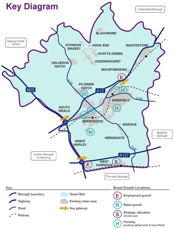
2.5 The key diagram below (Figure 2.1) shows the main aspects of the spatial strategy set within the broader local context.
Figure 2.1
2.6 Key features of the preferred approach and a description of how it was arrived at is given in the following paragraphs.
Protecting the Green Belt and the quality and character of the Borough
2.7 Eighty per cent of the Borough lies in Green Belt. Residents place a high value on protecting the Green Belt viewing this as their top priority for the development plan along with protecting the quality and character of the Borough. Other than the redevelopment of already developed sites within the Green Belt and a strategic allocation in West Horndon, the aim will be to minimise development in the Green Belt.
Developing within existing settlements
2.8 Over the plan-period the majority of new development is expected to take place in existing built up areas, primarily through the development, conversion or re-use of previously developed land and buildings. The Council will take a pro-active approach towards identifying and securing development in these locations along with the benefits that redevelopment can bring, for example, an enhanced public realm and new facilities.
Development in Villages excluded from the Green Belt
(2) 2.9 The Strategy allows for limited development in villages excluded from the Green Belt with a strategic allocation to be made at West Horndon. Taking into account homes already built and committed, together with the potential shown in the SHLAA, analysis of extant planning permissions and site appraisal work, 1700 new dwellings (net) can be expected to be built in these communities over the plan period, ie between 2015 and 2030. Out of this total, 1500 dwellings are expected to be built in West Horndon over the plan period.
Previously developed land within the Green Belt
2.10 Previously developed sites within the Green Belt in suitable locations adjacent to existing built up areas are expected to 178 of new dwellings (net). A strategic employment allocation at a former M25 works site will provide for new jobs and business.
Villages in the Green Belt
(1) 2.11 Other than small scale development to meet identified needs, very little development is expected to take place in these generally remote, landscape-sensitive locations which lack the facilities and infrastructure needed to support development.
Hierarchy of place
2.12 Within the Borough a settlement hierarchy can be discerned based on the characteristics of each settlement taking into account services and facilities available. These characteristics help suggest where might be best placed to accommodate growth in a sustainable manner.
Settlement Category 1: Main Town
2.13 Brentwood is the Borough’s
largest settlement and only town. Accessible and well served
by public transport, with rail stations at Brentwood and
Shenfield, the town provides a range of shopping, employment
areas, secondary schools, health and leisure facilities in
close proximity to residential areas. Brentwood town centre
is the Borough’s main focus for shopping, community and
leisure activities, supported by shopping facilities around
the rail station and other local shopping parades. Within
this settlement category, Brentwood and Shenfield offer the
most scope to develop in accordance with sustainable
development principles.
Settlement Category 2: Village Service Centres
2.14 A district shopping centre
with a good range of jobs, community and health facilities,
Ingatestone provides the second category in the hierarchy. As
the Borough’s largest village, facilities here serve a
significant catchment beyond immediate area. Public transport
accessibility is relatively good. The village has a rail
station and secondary school. While Ingatestone has
relatively good facilities, a modest level of development is
envisaged here, due to infrastructure constraints and a lack
of suitable sites.
Settlement Category 3: Larger Villages
(2)
2.15 Larger villages in the
Borough are served by a local shopping parade and a primary
school. They generally have limited community and health
facilities, local jobs and a variable bus service. As well as
these facilities, West Horndon has a rail station,
significant employment area and potentially some redundant
industrial land. Among the Borough’s villages it offers the
most scope for development. Remaining villages in this
category are Blackmore, Doddinghurst, Herongate, Ingrave,
Kelvedon Hatch and Mountnessing.
Settlement Category 4: Smaller Villages
2.16 These are remote, smaller
settlements, with poor public transport, limited shops, jobs
and community facilities and include the villages of South
Weald, Great Warley and Hook End.
Background work to inform the Spatial Strategy
2.17 Brentwood Sustainability Appraisal at Core Strategy Issues and Options stage concluded that a combination of transport led growth and semi-dispersed growth would provide the greatest sustainability benefits for the Borough. However, this conclusion was reached prior to technical work carried out since which sheds further light on opportunities and constraints.
2.18 Brentwood Water Cycle Study identifies constraints to developing in the north of the Borough which has a lack of sewerage treatment capacity. This limits spatial options available but does not affect the Council’s preferred strategy since proposed growth areas lie in central and southern parts of the Borough. Here there is more scope for sustainable development with better public transport, jobs and facilities and less impact on the Borough’s landscapes and rural character.
2.19 Brentwood SHLAA and subsequent analysis of potential sites, identifies sufficient land required to deliver the preferred spatial strategy while offering flexibility in how this is achieved.
(6) 2.20 National policy advises that local plans should be based on a strategy which seeks to meet objectively assessed development and infrastructure requirements, including unmet requirements from neighbouring authorities where it is reasonable to do so and consistent with achieving sustainable development. (NPPF, paragraph 182). Following a technical exercise to objectively assess development needs, as national policy advises, the Council has considered the implications for the Borough of meeting these needs. The preferred spatial strategy seeks to accommodate a significant proportion of this need. Due to significant capacity constraints, however, it is not possible to accommodate fully the scale of growth implied within the context of a coherent spatial strategy in accordance with sustainable development principles set out in the National Planning Policy Framework. Growth above a certain level would lead to significant impacts: notably harm to the landscape, Green Belt, settlement identity and character and town centre traffic congestion.
(1) 2.21 The NPPF advises planning authorities to look to neighbouring authorities to meet unmet need, where they cannot meet this themselves, through a ‘Duty to Cooperate’. The Council is exploring options in this regard. Policies S2 and S3 below deal with the quantum of development.
Evidence
Brentwood Scoping and Outline Water Cycle Study
(Entec, 2011)
Brentwood Strategic Housing Land Availability
Assessment (SHLAA) (Atkins, 2011)
Landscape Sensitivity Testing and Green Belt
Assessment (forthcoming)
Mid-Essex Landscape Character Assessment (2006)
Objectively Assessed Needs Assessment (PBA, 2013
forthcoming)
Transport modelling work (forthcoming)
Utilities Assessment (forthcoming)
Consultation
In 2009, the Council consulted on four spatial options as part of an Issues and Options consultation Pathway to a Sustainable Brentwood. The most popular was Option 1 - Centralise growth in and around the town of Brentwood, followed by Option 2 Transport led growth, and Option 3 - Semi-dispersed growth – develop around Brentwood town and the main villages. Option 4 - Dispersed growth - develop at all settlements across the Borough) was the least popular option.
National Policy
NPPF paragraph 14: At the heart of the National
Planning Policy Framework is a presumption in favour of
sustainable development, which should be seen as a golden
thread running through both plan-making and decision-taking.
For plan-making this means that:
- local planning authorities should positively seek opportunities to meet the development needs of their area;
-
Local Plans should meet objectively assessed needs, with
sufficient flexibility to adapt to rapid change,
unless:
- any adverse impacts of doing so would significantly and demonstrably outweigh the benefits, when assessed against the policies in this Framework taken as a whole; or
- specific policies in this Framework indicate development should be restricted.
NPPF Core Principle, Paragraph 17: Plans should set out a clear strategy for allocating sufficient land which is suitable for development in their area, taking account of the needs of the residential and business communities.
NPPF, Paragraph 182: One of four ‘soundness tests’, the plan should demonstrate that is has been ‘Positively prepared’: the plan should be prepared based on a strategy which seeks to meet objectively assessed development and infrastructure requirements, including unmet requirements from neighbouring authorities where it is reasonable to do so and consistent with achieving sustainable development.
Target
Development in accordance with the Spatial Strategy
Indicator
Development Monitoring
Delivery
Development Management
Land Allocations
(687) S2: Amount and Distribution of Residential Development 2015-2030
Provision is made for 3,500 new dwellings (net) to be built in the Borough between March 2015 and March 2030 at an annual average rate of 200 new dwellings 2015-2020 rising to 250 new dwellings 2020-30 to be distributed as follows:
|
Location |
Number of net new dwellings |
% of total requirement |
|
Brentwood and Shenfield Urban Area |
1,800 |
51% |
|
West Horndon |
1,500 |
43% |
|
Villages excluded from the Green Belt (other than West Horndon) |
200 |
6 % |
|
Villages in the Green Belt |
0-15 |
0-1% |
Sites with a capacity for 10 or more dwellings (major housing sites) allocated for residential development are shown on the Policies Map.
(1) Alternative Growth Options
Alternative Option 1 – 4,960 to 5,600 dwellings (331 to 373 homes a year) - Objectively Assessed Need
Reason for rejection: This level of growth would require significant Green Belt release, significantly worsen congestion in Brentwood Town Centre and irrevocably change the rural character of the Borough. Significant investment in infrastructure and services would be required to support this level of growth and there is no guarantee this would be forthcoming. This option fits poorly with the Council’s preferred spatial strategy and available alternatives.
Alternative Option 2 – 2,625 (175 homes a year) – (comparable to former RSS/East of England Plan target)
Reason for rejection: This level of growth could be accommodated with less Green Belt release than the Council’s preferred option, relying mainly on redeveloping brownfield sites. While environmentally this option has clear advantages it would fall further short of objectively assessed need than the Council’s preferred level of growth and may be harder to justify in light of national policy requirements.
Justification
2.22 This policy sets how many dwellings the Borough will accommodate over the plan period. Figures include existing commitments (permissions and allocations) and take account of housing potential on sites identified through the Brentwood Strategic Housing Land Availability Assessment (SHLAA) (2011) and related exercises, including the Council’s asset review. Reflecting prevailing economic conditions, land availability and realistic prospects for deliverability, an average annual target for house building is lower for the first five years of the plan increasing thereafter for the remaining 10 years.
2.23 The Government expects Local Plans to meet objectively assessed needs for market and affordable housing, with sufficient flexibility to adapt to rapid change unless the adverse impacts of doing so would significantly and demonstrably outweigh the benefits (NPPF, paragraph 14).
2.24 In deciding how many homes the Borough should plan for, the Council has taken into account national policy and evidence on the number and kind of homes needed and the capacity to accommodate new development while maintaining the Borough’s distinctive quality and character. Availability of supporting services and infrastructure are also key considerations which affect capacity.
Background work to inform the housing figure
2.25 Until recently, regional plans set local housing targets. The Localism Act introduced provisions to abolish regional plans and enable Councils to set their own targets. Previously, the East of England plan set a requirement for Brentwood for 3,500 net additional dwellings between 2001 and 2021 of which between 2001 and 2011, 2,321 dwellings were built (net additions), leaving a requirement to provide 1,179 dwellings to 2021, (the remaining RSS period).
(2) 2.26 National policy makes it clear that the Government expects the household and population projections to be the starting point in determining ‘objectively assessed need’ for development, taking into account migration and demographic change, which in turn plans should seek to accommodate.
2.27 The Department for Communities and Local Government project an increase in the number of households in the Borough from 31,000 in 2011 to 34,000 in 2021 (CLG, 2011 interim Household Projections).
2.28 The Borough faces a high level of demand for housing from people seeking to move into the area. Around 80 per cent of projected household growth between 2010 and 2033 arises from people expected to move here, mainly from elsewhere in the UK. The remainder is from natural change - an excess of births over deaths (Office for National Statistics (ONS) 2010 based sub national population projections).
Objectively Assessed Need
(29) 2.29 To enable the Council to reach an informed view on objectively assessed needs and in light of this, how many homes the Borough can sustainably accommodate, technical work has been commissioned. This includes the following studies: Objectively Assessed Needs For Brentwood (Working Draft Report, 2013), Housing Growth Scenarios (2012), Landscape and Green Belt Assessment, Transport modelling, Utilities Study (forthcoming) and SHMA update (forthcoming).
2.30 A study to consider objectively assessed needs has been carried out by Peter Brett Associates on behalf of the Council. Work undertaken as part of the study includes consideration of 13 demographic forecasts produced by Edge Analytics for Essex Planning Officers Society and a review of the Department for Communities and Local Government (CLG) and ONS projections. The study concludes a figure of somewhere between 331 and 362 homes a year would represent objectively assessed need for the Borough.
Capacity considerations
2.31 A Housing Growth Scenarios study, commissioned by Brentwood BC, Maldon DC and Chelmsford CC, examined the implications of growth at different levels: Population Stable - 1,680 dwellings over the plan period (112 homes a year); Workforce Stable - 1,950 (125 homes a year) and ONS/CLG projections - 6,000 (400 homes a year). The first scenario, Population Stable - reflects the number of new homes required to keep the Borough population the same size as it is now after taking into account a fall in the average household size. The second scenario, Workforce Stable, reflects the number of new homes required to keep the workforce the same size at present (taking into account the ageing population, but assuming the proportion commuting remains unchanged). For the third scenario the study used CLG and ONS (2010 based) population and household projections (it should be noted that subsequent 2011 based projections project a lower rate of growth). A sustainability appraisal shows positive and negative impacts for all three scenarios. The lower scenarios perform well environmentally, but less well economically and socially. The study notes that growth at the level of ONS/CLG projections (6,000 homes over the plan period) would give rise to significant adverse impacts in terms of urban sprawl, congestion, harm to landscape and ecology and substantial loss of Green Belt. This study did not specifically consider objectively assessed needs.
(3) 2.32 The Council’s preferred level of growth has been informed by a comprehensive analysis of site and location constraints and opportunities. Evidence suggests there exists capacity to accommodate development in the Borough up to around 3,500 homes over the plan period. Above this, the consequences of development would cause irrevocable harm and it would become harder to deliver development in a sustainable manner: that is in places with good access to services, public transport, jobs and facilities while safeguarding local character and environmental quality. Evidence suggests that a higher level of growth would significantly worsen existing traffic congestion problems (Traffic Modelling Study – forthcoming); require sites to be developed in landscape sensitive locations; be difficult to service with necessary infrastructure; and have a generally urbanising effect through widespread loss of Green Belt affecting the identity and setting of Brentwood Town and neighbouring settlements and the Borough’s rural character.
Land availability
(1) 2.33 Brentwood SHLAA provides an overview of potential housing land availability. Following an open call for sites exercise in 2009, whereby interested parties were invited to put forward suggestions, an exercise was carried out to identify and assess land to determine whether it is available, suitable and achievable. The SHLAA identifies more land than would be required to meet housing requirements, although not all potential sites meet broader policy considerations. The present five year housing trajectory identifies sufficient deliverable sites to meet requirements. For the longer term, housing land supply is expected to come forward as follows:
Components of housing land supply 2015 – 2030 (Net New dwellings)
| Existing commitments | 589 |
| Site allocations | 2,522 |
| Small sites allowance | 67 |
| Windfall allowance | 322 |
| TOTAL | 3,500 |
2.34 Minimal allowance has been made for windfall sites although in practice these are expected to contribute towards supply. For the past five years windfalls on non-residential sites account for 22% of total housing completions in the Borough. Any additional windfall can therefore provide some contingency in the event that sites do not come forward as and when planned. Sites less than 10 dwellings are not allocated but included in a small sites allowance.
The need and demand for housing
2.35 Brentwood’s Strategic Housing Market Assessment (2010) identifies a high level of need for affordable housing within the Borough which has among the most expensive housing in Essex, comparable to London house prices. Local wages, however, do not compare well with London and many local workers cannot afford to live here. This makes it harder for business to recruit, increases commuting and worsens transport congestion and quality of life.
2.36 Lack of funding for affordable housing is a significant barrier to meeting objectively assessed needs. The plan seeks to maximise affordable housing provision in light of identified needs: the suggested approach aims to be both aspirational and pragmatic. Commitments to protect the Green Belt, quality and character of the Borough and ensure adequate infrastructure to serve residents (existing and new) precludes an approach which seeks to accommodate the totality of market demand.
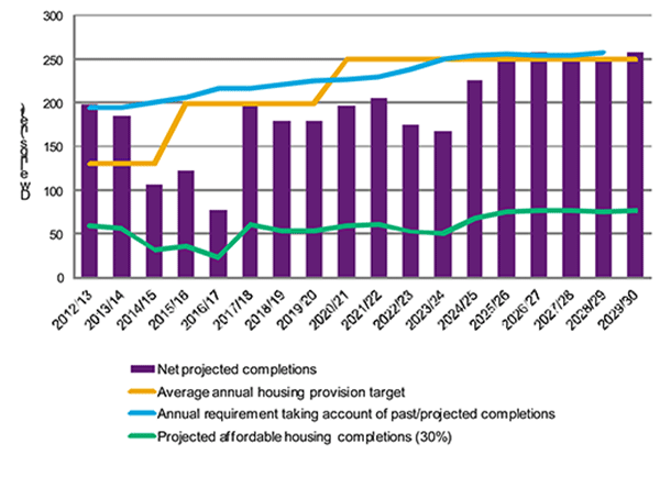
Brentwood Borough Housing Trajectory
(1) 2.37 Figure 2.2 sets out the expected rate at which new homes will be provided in the Borough over the plan period. The Trajectory is based on information about sites with the potential to deliver housing over the next 15 years, taken from the Strategic Housing Land Availability Assessment and work on Local Plan allocation sites. Further detail on the Housing Trajectory is given in Appendix 3.
Figure 2.2: Housing Trajectory
Evidence
Brentwood Housing Strategy - forthcoming
Brentwood Strategic Housing Land Availability
Assessment (Atkins, 2010)
CLG Household Projections
Essex Planning Officers’ Society Stage 3 Demographic
Forecasts (2012) Stage 4 (forthcoming).
Heart of Essex Housing Growth Scenarios Study
(2012)
Infrastructure Delivery Plan (forthcoming)
Landscape Sensitivity Testing and Green Belt
Assessment (forthcoming)
Laying the Foundations: A Housing Strategy for England
(2011)
Objectively Assessed Needs For Brentwood (Working
Draft Report, (Peter Brett Associates, March 2013)
Office for National Statistics 2010 based Sub-National
Projections
Strategic Housing Market Assessment (SHMA) –
forthcoming
Site Analysis (BBC)
Traffic Modelling (forthcoming)
National Policy
NPPF paragraph 47: To boost significantly the supply of housing, local planning authorities should use their evidence base to ensure that their Local Plan meets the full, objectively assessed needs for market and affordable housing in the housing market area, as far as is consistent with the policies set out in this Framework.
NPPF paragraph 182: the plan should be prepared based on a strategy which seeks to meet objectively assessed development and infrastructure requirements, including unmet requirements from neighbouring authorities where it is reasonable to do so and consistent with achieving sustainable development.
NPPF paragraph 17 Core Principle: Planning should take account of the different roles and character of different areas, promoting the vitality of our main urban areas, protecting the Green Belts around them, recognising the intrinsic character and beauty of the countryside and supporting thriving rural communities within it.
Consultation feedback
In 2011 Brentwood held an extensive consultation looking at new housing provision and the strategic policy direction in the Borough. (Your Neighbourhood Consultation report, November 2011). Overwhelming feedback from respondents showed a desire to protect the Green Belt, quality and character of the Borough and therefore limit the growth of new homes which are perceived to threaten the Green Belt.
The consultation sought views on priorities for the development plan and the draft regional plan target of 170 homes a year (as proposed by the East of England Regional Assembly, March 2010). 59% (890) of respondents disagreed with the housing target , 35% (537) agreed. 6% (97) did not know. Out of respondents who disagreed 92% (820) said the target too high; 1.5% (13) too low. Reasons for disagreeing with the target include concerns about infrastructure, transport, over-development and population and the need to protect the Green Belt, local character and re-use existing buildings. Some support was shown for providing affordable housing to meet local needs.
Target
An average completion rate of 200 dwellings per annum between 2015 and 2020 and 250 dwellings per annum between 2020-2030. This equates to an annual average of 233 dwellings per annum over the Plan period
Indicator
Authority Monitoring Report indicators: housing completions compared with housing trajectory.
Distribution of housing development compared with spatial strategy.
Delivery
The Council has agreed a Local Investment Plan in partnership with the Homes and Communities Agency (2011).
Actions identified through the Borough Housing Strategy (in preparation).
Through a comprehensive review of assets it owns and discussions with partners and stakeholders, the Council will take a pro-active approach to identifying and realising opportunities for new housing in suitable locations on publicly owned land.
RSLs, Housebuilders
(17) S3: Job Growth and Employment Land
Provision is made for 5,400 additional jobs to be provided in the Borough between March 2015 and March 2030 at an annual average rate of 285 to be distributed as follows:
| Total Area | Indicative Job Growth | |
| Existing Employment sites (B-use) | 53 hectares | - |
| New employment allocations (B-use) | 31 hectares | 5,400 |
| Retail, hotel and leisure uses | - | - |
Providing for this many jobs will require a total of 31 hectares of new employment land. Areas allocated for employment purposes are set out in Policy DM6 and identified on the Policies Map.
Alternative Growth Options
Draft RSS > 2031 – 3,700 jobs (2011-2031, 185 net additional jobs per year)
The Draft RSS Revision to 2031 gave an indicative figure for Brentwood Borough of 3,700 net additional jobs (2011-2031).
Reason for rejection: This RSS Review progressed no further and the Council has since obtained more up-to-date evidence (Heart of Essex Economic Futures 2012).
Dwelling Constrained – 4,800 jobs (2012-2031, 250 net additional jobs per year)
The Heart of Essex Economic Futures Study sets out two scenarios for economic growth to 2031. The Dwelling Constrained Scenario projects job growth and the amount of employment land required assuming 170 homes are built per year in the Borough (Former RSS figure). However, this does not accommodate issues such as local land constraints, subsequently requiring 9.4 ha of additional B-use employment land, including significant distribution warehouse floorspace. Given the Borough’s Green Belt location this type of land requirement is not considered to be an appropriate option.
Reason for rejection: The Preferred Policy is based on the study’s second growth scenario, Sector Derived. This scenario takes account of planned economic investment and intelligence as the basis for modelling an uplift factor, identified in consultation with Brentwood for Growth.
Justification
(1) 2.38 This policy sets out how many new jobs are to be provided in the Borough over the plan period and how much additional employment land will be allocated to provide these. Reflecting the Borough’s desirable location, high quality and distinctive offer and land constraints, the Council’s preference is for efficient land use and the creation of and provision for high value business. With regard to the rural economy, the preferred approach seeks to encourage rural enterprise which benefits local communities while respecting the quality and character of the countryside.
Background work to inform the Employment Target
2.39 With the abolition of Regional Spatial Strategies, a baseline figure for local job growth is now something that needs to be determined to inform future planning policy. As a result, the Council is required to determine its own locally-derived employment targets. Together with the other Heart of Essex Partnership authorities, comprising Chelmsford City Council and Maldon District Council, the Council commissioned Nathaniel Lichfield & Partners (NLP) and Experian to prepare an Economic Futures Study for the Heart of Essex sub-region.
2.40 The Economics Futures Study developed two potential future scenarios to consider economic futures in the Heart of Essex. The outputs of each scenario are expressed in terms of total employment (including self-employed) and Gross Value Added (GVA), which provides a measure of economic output as follows:
- Dwelling constrained scenario: A dwelling constrained scenario for Brentwood has been developed based upon both current assumptions at a regional and UK level as to how the economy will perform, constrained to a housing figure for Brentwood of 170 dwellings per annum. The scenario also takes into account the strengths and historic trends within the local economy. The scenario suggests that total employment will grow 0.6% per annum between 2012 and 2031 to just less than 43,200 in Brentwood. This equates to an additional 4,800 jobs over the next two decades and is in line with the County and UK average. It is however behind the East of England average of 0.8 per cent growth year on year. This indicates growth of 1,250 B-class jobs, mainly reflecting growth in office-based and warehousing sectors, which more than offsets loss of manufacturing jobs. B-Class job forecasts have been converted to future employment space requirements. This results in a net B-Class requirement of 44,400sq.m (9.4ha) over period 2012- 2031.
- Sector derived scenario: This alternative “sector driven” scenario takes account of planned investment or intelligence about future sectors as the basis for modelling an uplift factor (on top of the dwelling constrained scenario) applied to the growth rates for individual sectors by 2031. This scenario generates a higher level of employment growth by 2031 than is implied by the dwelling constrained scenario. Economic output increases by 16% (1,525 B-class Jobs) in Brentwood. This is as a result of increased growth of office-based sectors and a reduction in manufacturing losses, while warehousing sectors have been further constrained. This results in a net requirement of 36,038sq.m (6.8ha) over period 2012-2031.
2.41 For both scenarios, the employment land requirement is significantly greater than the 4ha of land currently identified as available for employment development in the Borough. The 6.8ha requirement arising by the sector derived scenario is of similar magnitude to the requirement identified by the 2010 Brentwood Employment Land Review (ELR), but the dwelling constrained scenario is somewhat higher at 9.4 ha. However, the potential total B-class floorspace requirement identified through this study, 36,000 – 44,500sq.m, is lower than the 2010 ELR Study reflecting different underlying assumptions about which sectors’ growth will occur within, as well as generally more up to date forecasts, that reflect the long term impact of the recession to a greater extent than the 2009 East of England Forecasting Model results which underpinned the 2010 ELR analysis.
2.42 The ELR prepared for Brentwood in 2010 sets out the future availability of employment land in the Borough as follows:
2.43 Vacant and opportunity land together provide a theoretical capacity of 20,000sq.m. Sectoral forecasts prepared for the study identified a net growth of 41,000 jobs in the Borough to 2031. The future requirement would be for an additional 47,500sq.m B1a office space (equivalent to 6.3ha).
2.44 A local business survey, carried out as part of the ELR, identified a high level of satisfaction with current business premises. In order to expand 50 per cent of businesses surveyed stated they would require additional space and the majority were unable to accommodate their additional floorspace needs at their existing premises. The study recommended provision should be made for a net additional increase of 71,000sq.m B- Class floorspace in Brentwood to 2031. Given the tightness of identified future supply relative to demand, it was recommended the Council consider allocating new employment sites.
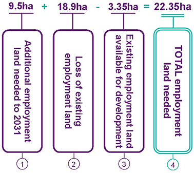
2.45 The findings of these studies inform the amount of land the Council needs to provide for economic growth. This calculation is summarised in Figure 2.3, which gives a breakdown of new B-use employment land required to inform Draft Plan allocations. It should be noted that suggested employment allocations exceed requirements. This calculation is explained below:
- The amount of additional employment land needed to 2031 is taken from the Council’s Employment Land Review (2010), which is verified in the Heart of Essex Economic Futures dwelling constrained scenario for Brentwood Borough (2012).
- The total amount of existing employment land lost to preferred housing allocations is taken from three sites to be allocated for housing/mixed use.
- Existing employment land available for development is made up of unused employment allocations from the Brentwood Replacement Local Plan (2005) and extant planning permissions for employment land at April 2012. The 2011/12 AMR sets out net employment land available at April 2012 to be 4ha (1.13ha extant planning permissions and 2.87ha extant allocations). Taking away unused employment land at the Council Depot in Warley ((draft housing allocation 081) 0.65ha of unused land) this reduces the total available land to 3.35 ha.
- Figure 2.3 shows these elements combined result in a total additional employment land requirement of 22.35ha.
Figure 2.3: Employment Land Need
Employment Allocations
(1) 2.46 Major employment sites contributing to the Borough’s job growth over the period 2015 to 2030 are identified on the Policies Map and listed in Policy DM6. Estimated capacity is based on calculating on employment density by sector type as set out in the Heart of Essex Economic Futures Study and subsequent analysis.
Evidence
Employment Land Review (2010)
Heart of Essex Economic Futures Study (2012)
National Policy
NPPF paragraph 9: Pursuing sustainable development involves seeking positive improvements... making it easier for jobs to be created in cities, towns and villages.
NPPF paragraph 17, core planning principle: Planning should proactively drive and support sustainable economic development to deliver the homes, business and industrial units, infrastructure and thriving local places that the country needs. Every effort should be made objectively to identify and then meet the housing, business and other development needs of an area, and respond positively to wider opportunities for growth.
NPPF paragraph 18 emphasises the Government’s commitment to securing economic growth in order to create jobs and prosperity and in meeting the twin challenges of global competition and of a low carbon future.
NPPF paragraph 19 states that significant weight should be placed on the need to support economic growth through the planning system.
NPPF paragraph 20: To help achieve economic growth, local planning authorities should plan proactively to meet the development needs of business and support an economy fit for the 21st century.
NPPF paragraph 21: .In drawing up Local Plans, local planning authorities should:
- Set out a clear economic vision and strategy for their area which positively and proactively encourages sustainable economic growth
- Set criteria, or identify strategic sites, for local and inward investment to match the strategy and to meet anticipated needs over the plan period
- Support existing business sectors, taking account of whether they are expanding or contracting and, where possible, identify and plan for new or emerging sectors likely to locate in their area. Policies should be flexible enough to accommodate needs not anticipated in the plan and to allow a rapid response to changes in economic circumstances
- Plan positively for the location, promotion and expansion of clusters or networks of knowledge driven, creative or high technology industries
- Identify priority areas for economic regeneration, infrastructure provision and environmental enhancement
- Facilitate flexible working practices such as the integration of residential and commercial uses within the same unit
NPPF paragraph 22: Planning policies should avoid the long term protection of sites allocated for employment use where there is no reasonable prospect of a site being used for that purpose. Land allocations should be regularly reviewed. Where there is no reasonable prospect of a site being used for the allocated employment use, applications for alternative uses of land or buildings should be treated on their merits having regard to market signals and the relative need for different land uses to support sustainable local communities.
NPPF paragraph 28: Planning policies should support economic growth in rural areas in order to create jobs and prosperity by taking a positive approach to sustainable new development.
NPPF paragraph 160: Local planning authorities should have a clear understanding of business needs within the economic markets operating in and across their area. To achieve this, they should:
- work together with county and neighbouring authorities and with Local Enterprise Partnerships to prepare and maintain a robust evidence base to understand both existing business needs and likely changes in the market; and
- work closely with the business community to understand their changing needs and identify and address barriers to investment, including a lack of housing, infrastructure or viability.
NPPF paragraph 161: Local planning authorities should use this evidence base to assess:
- the needs for land or floorspace for economic development, including both the quantitative and qualitative needs for all foreseeable types of economic activity over the plan period, including for retail and leisure development;
- the existing and future supply of land available for economic development and its sufficiency and suitability to meet the identified needs.
Target
An average growth rate of 285 net additional jobs per annum over the Plan period
Indicator
Number of jobs in the Borough (full time equivalent)
Authority Monitoring Report indicators: actual non-residential development
Distribution of non-residential and retail development compared with spatial strategy
Net change in employment land provision as a result of planning permissions and changes of use for B1, B2 and B8 purposes
Delivery
Allocation of a range of sites and better utilisation of existing employment sites to provide higher quality employment and more jobs.
Through a comprehensive review of assets it owns and discussions with partners and stakeholders, the Council will take a pro-active approach to identifying and realising opportunities for new employment growth in suitable locations on publicly owned land.
(5) S4: Provision for Retail and Commercial Leisure
Provision is made for 7,275 sqm (net) of comparison retail floorspace and 4,277 sqm (net) of convenience floorspace to be provided in the Borough up to March 2030. The primary location for new retail growth will be Brentwood Town Centre. Provision will also be made at West Horndon as part of a mixed use development.
Justification
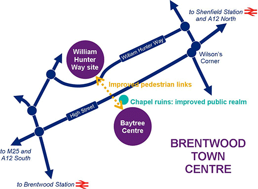
(1) 2.47 Growth in retail and commercial leisure is expected to make a significant contribution towards job growth in the Borough. The planned redevelopment of William Hunter Way car park will provide mixed use retail and leisure development, including a foodstore and multiplex cinema. Redevelopment of this key site will provide opportunities for investment, additional retail and attract more visitors, helping to ensure the town centre remains a competitive retail location. There will be further opportunities for retail provision through the redevelopment of the Baytree Centre; as part of a mixed use scheme at West Horndon; and elsewhere through the redevelopment of smaller sites.
2.48 Brentwood Town Centre is the Borough’s focus for shopping, cultural, leisure community and employment uses.
2.49 Figure 2.4 sets out the retail allocations and opportunities for improved links between these. Improved links will also help increase the amount of linked trips to High Street stores. Opportunities to improve the public realm around the Chapel ruins site as part of redevelopment of the Baytree Centre will help create a new ‘town square’. This will provide new and attractive public space while making more of the Chapel ruins and protecting this ancient monument.
(1) 2.50 The Council’s Preferred Option is to include Warley Hill (area around Brentwood Station) within the Brentwood Town Centre boundary, as shown on the Policy Map. This differs from the 2005 Replacement Local Plan which separates the two centres. Brentwood Retail and Commercial Leisure Study (2011) recommends setting a boundary for Warley Hill centre and this will be achieved by including it within the wider Brentwood Town Centre. This option will also assist in the aim to better link the station area with the High Street, as was the rationale for including a wider boundary in Brentwood Town Centre Regeneration Strategy (2010).
(1) 2.51 Shenfield is home to a major railway station with fast train services to central London. It will be the terminus for Crossrail and it is vital that the most is made of this opportunity to invest in improving Shenfield’s retail and leisure offer.
Background Studies to inform the Retail Policy
2.52 A Retail and Commercial Leisure Study was undertaken by consultants Chase and Partners in 2011 to assess retail and commercial leisure growth to 2031 in line with the timescale for the Council’s emerging local development plan. A quantitative need assessment formed part of the study and concluded a reasonable level of need for both convenience (4,491sq.m) and comparison (5,963sq.m) goods floorspace by 2031. Although current economic uncertainty will undoubtedly have an effect on consumer expenditure and will constrain the need for development in the town centre in the short term, the potential for new convenience and comparison floorspace over the medium/long term is clear.
2.53 As part of the assessment Chase & Partners commissioned a household survey. Those surveyed were within an agreed catchment area where Brentwood town centre and the Borough’s other main retail centres exert an influence over existing shopping behaviour. From this it is possible to identify the relationship between the town and other nearby retail centres – including Billericay, Basildon, Chelmsford, Romford and the shopping centres at Lakeside and Bluewater – particularly for comparison goods shopping.
2.54 Brentwood Retail and Commercial Leisure Study notes that the redevelopment of William Hunter Way will meet forecast retail need in the medium term. Other opportunities exist to provide additional retail floorspace in Brentwood Town Centre through the redevelopment of the Baytree Centre. Town centre opportunities are shown below:
Figure 2.4
Evidence
Brentwood and Epping Forest Employment Land Review
(2010)
Brentwood Retail and Commercial Leisure Study
(2011)
East of England Regional Plan Review (March 2010)
Greater Essex Study (2009)
Heart of Essex Economic Futures Study (2012)
National Policy
NPPF paragraphs 23-27:
Planning policies should be positive, promote competitive
town centre environments and set out policies for the
management and growth of centres over the plan period. In
drawing up Local Plans, local planning authorities
should:
- Recognise town centres as the heart of their communities and pursue policies that support their vitality and viability;
- Define a network and hierarchy of centres that is resilient to anticipated future economic changes;
- Promote competitive town centres that provide customer choice and a diverse retail offer and which reflect the individuality of town centres;
- Allocate a range of suitable sites to meet the scale and type of retail, leisure, commercial, office, tourism, cultural, community and residential development needed in town centres. It is important that needs for retail, leisure, office and other main town centre uses are met in full and are not compromised by limited site availability. Local planning authorities should therefore undertake an assessment of the need to expand town centres to ensure a sufficient supply of sustainable sites;
- Allocate appropriate edge of centre sites for main town centre uses that are well connected to the town centre where suitable and viable town centre sites are not available. If sufficient edge of centre sites cannot be identified, set policies for meeting the identified needs on other accessible locations that are well connected to the town centre;
- Set policies for the consideration of proposals for main town centre uses which cannot be accommodated in or adjacent to town centres;
- Recognise that residential development can play an important role in ensuring the vitality of town centres and set out policies to encourage residential development on appropriate sites; and
- Where town centres are in decline, local planning authorities should plan positively for their future to encourage economic activity.
NPPF, Paragraph 24 requires that the sequential test be applied to applications for main town centre uses that are not in an existing centre.
Issues and Options Consultation Feedback
In 2011 the Council carried out an extensive consultation allowing residents, business and stakeholders to have their say on local plan issues. Feedback included a desire to see town centres thrive, with a good mix of shops and convenient parking. Residents in smaller centres are keen to maintain local shops and facilities. When asked what could be improved a common response was ‘more or better shops’. Key issues raised regarding the Borough’s centres was the need for a mix of shops, including provision for independent business and ‘niche’ shopping and better management of the nigh-time economy.
Target
New employment floorspace (retail/ leisure)
Indicator
Development monitoring – new retail/ leisure floorspace
Level of vacant retail units in Borough centres
Delivery
Development Management and site allocations