Brentwood Local Plan 2016 - 2033 (Pre-Submission, Regulation 19)
9. Site Allocations
(6) 9.1 Site allocations listed in this chapter reflect the spatial strategy and strategic objectives.
9.2 Each policy follows a similar format, providing the basis for how development is expected to come forward and key considerations. The following sub-headings are included for each site:
- Amount and type of development: Sets out an approximate number of new homes considered appropriate for a site according to certain characteristics, such as surrounding density and character, and the amount of land considered to be developable (i.e. not including areas that will not be developed within a site, like gardens or roads). The number of new homes on a site is indicative, and in each case, the Council will consider the need to maximise development according to policies within the Plan. Where appropriate for some residential allocations the land requirements for education and early years and child care facilities are stated. In addition any land/floorspace requirements for employment and retail provision are included. For employment allocation policies, figures stated for hectares of employment land are more accurate and should be adhered to as a starting point.
- Development principles: Sets out the wider principles of development on site that should be considered further through the decision-making process.
- Infrastructure requirements: Sets out the specific requirements for each site that are expected to be delivered alongside development. These are not exhaustive, and any planning application should look to consider wider infrastructure needs informed by evidence, such as the Council's Infrastructure Delivery Plan (IDP). In determining appropriate contributions for infrastructure reference should also be made to Policy SP04.
9.3 Where reference is made to the type and size and new homes, the local character should also be considered.
(3) 9.4 Affordable housing should be provided in line with Policy HP05, as well as considerations for specialist housing, Policy HP04.
(1) 9.5 The trajectory is not fixed, it gives an indication to how we think things will come forward within a phased approach and taking account of the ability to build in infrastructure. However, proposals should show whether development can be delivered sooner. The Council is committed to delivering new homes swiftly, in line with the government's aims.
(1) 9.6 Where sites with more than one landownership are allocated, policies set out the need for joint working. However, this does not preclude multiple planning applications being submitted, these applications should evidence consideration of other sites and working together on proposals. This is reflected in individual site allocation policies.
(4) 9.7 This chapter is split according to strategic sites and non-strategic sites for both housing-led and employment development. Sites are listed as follows:
Strategic Housing Allocations:
R01 Dunton Hills Garden Village Strategic Allocation
R02 Land at West Horndon Industrial Estate, West Horndon
R03 Land North of Shenfield, Shenfield
R04 & R05 Ford Headquarters and Council Depot, Warley
Housing Allocations:
R06 Land at Nags Head Lane, Brentwood
R07 Sow and Grow Nursery, Pilgrims Hatch
R08 Land at Mascalls Lane, Warley
R09 Land at Warley Hill, Warley
R10 Brentwood Railway Station Car Park, Brentwood
R11 Westbury Road Car Park, Brentwood
R12 Land at Hunter House, Brentwood
R13 Chatham Way Car Park, Brentwood
R14 William Hunter Way Car Park, Brentwood
R15 Wates Way Industrial Estate, Brentwood
R16 & R17 Land off Doddinghurst Road, Pilgrims Hatch and Brentwood
R18 Land off Crescent Drive, Shenfield
R19 Land at Priests Lane, Shenfield
R20 The Eagle and Child Public House, Shenfield
R21 Land South of Ingatestone, Ingatestone
R22 Land Adjacent to the A12, Ingatestone
R23 Brizes Corner Field, Kelvedon Hatch
R24 Land off Stocks Lane, Kelvedon Hatch
R25 Land North of Woollard Way, Blackmore
R26 Land North of Orchard Piece, Blackmore
Strategic Employment Allocations:
E11 Brentwood Enterprise Park
Employment Allocations:
E12 Childerditch Industrial Estate
E10 Codham Hall Farm
E13 Land at East Horndon Hall
E08 Land Adjacent to A12 and Slip Road, Ingatestone
(78) Dunton Hills Garden Village
(1) Background
9.8 The National Planning Policy Framework (2018, Section 5 Delivering a Sufficient Supply of Homes) sets out how the plan-making process should positively plan to identify appropriate land for homes. It goes further to states that a significant step towards meeting the housing shortage is through larger scale development, such as new settlements or significant extensions to existing villages and towns.
9.9 The Council's strategy for growth has considered all potential brownfield sites and previously developed underutilised land within the main urban area, and this has formed the Central Brentwood Growth Corridor. However, with 89% of the borough falling within the Metropolitan Green Belt of London, it has meant that the Council has had to make some difficult decisions about the most sustainable areas where its housing needs could be delivered. This has meant the Council has undergone a review of potential locations to determine the considered balance between minimising the impact on the Green Belt and ensuring chosen locations are sustainable – that is the most accessible and least harmful to key environmental designations. The assessment concluded, as detailed in the Sustainability Appraisal, that the south Brentwood locations were deemed the most suitable locations; this has determined the South Brentwood Growth Corridor strategy.
(3) 9.10 Dunton Hills was selected as a strategic allocation (ref R01) to meet the majority of Brentwood's housing need, within the Plan period and beyond. Given its proximity to the A127, to West Horndon railway station, and to nearby employment areas, development at Dunton Hills provides a unique opportunity to deliver a sustainable new settlement. Its size means supporting infrastructure can also be delivered, thereby relieving the impact on existing facilities that are at capacity. Providing a significant amount of development will help reduce pressure to alter the Green Belt boundaries again in the next Plan period.
9.11 In January 2017, Dunton Hills was announced as one of 14 proposed garden villages across England receiving funding to take plans forward and to help timely delivery of the development. The site at Dunton Hills offers a unique opportunity to deliver a new settlement that meets both Garden Community principles as well as Brentwood's growth strategy.
9.12 The site is approximately 259.2 ha and is bounded by A128 (Tillbury Road / Brentwood Road) on the west; the A127 (Southend Arterial Road) on its northern edge; the London, Tilbury & Southend C2C Railway on its southern edge; and the borough boundary on its eastern edge. The B148 (West Mayne) is the eastern road beyond the borough boundary separating the site from the built-up area of Basildon.
9.13 Its location is ideally placed to align with the principles of Garden Communities. It is connected enough to make it a sustainable location; at the same time physically contained and surrounded by countryside to not only align to Brentwood's Borough of Villages character, but also continue to maintain characteristics of Green Belt openness.
(1) A Spatial Vision for Dunton Hills
(1) 9.14 Dunton Hills Garden Village (DHGV) will be holistically planned, self-sustaining and characterful. The development will align to the principles and qualities for Garden Communities as set out in two key publications: the TCPA Garden Villages Guidance by the TPCA (2017)[1] which incorporates the 'Garden City Principles', and the government's Prospectus on 'Garden Communities' (MHCLG, 2018)[2]. While the principles listed in these two publications differ slightly, their intention is the same. Garden Communities are 'holistically planned new settlements that enhance the natural environment and offer high-quality affordable housing and locally accessible work in beautiful, healthy and sociable communities' (TCPA, 2017). MHCLG further states that there are clear expectations to ensure these new developments achieve and maintain the necessary quality so that they become 'vibrant, mixed-use, communities where people can live, work and play for generations to come – communities which view themselves as the conservation areas of the future'.
9.15 The Garden Community principles should be seen as an indivisible and interlocking framework for delivery. These principles can be organised into those which define the expected qualities of the development; those which relate to the delivery process; and those necessary to ensure sustainable management of the garden village into the future. This division broadly aligns to the three overarching strategic objectives for Dunton Hills Garden Village.
9.16 Dunton Hills should form a place where people will want to live, where they feel healthy and happy and which provides opportunities to prosper and flourish. Dunton Hills must not be the type of dormitory 'non-place' that has so often become the norm for such developments in the recent past.
(1) 9.17 The policy framework is set out as three interrelated policy domains:
- The Strategic Allocation – describing the overarching site requirements and land use parameters;
- The Spatial Design – prescribing the physical components needed to deliver the necessary quality for a healthy, liveable and sustainable village; and
- The Delivery Approach and Legacy Management – setting out the expectations for how the delivery of the scheme should be approached to embed an ethos of co-design and participation, timely and good governance in delivery, and an embedded legacy management of the village assets.
9.18 The Council requires development proposals to demonstrate how they will deliver the ambitions set out in the vision statement and the strategic objectives.
(1) DHGV Strategic Aims and Objectives
9.19 The vision for Dunton Hills is summarised as three overarching aims, each supported by a number of sub-objectives that together provide the link between the vision and the development strategy (illustrated in Figure 9.1). These form the fundamental development principles to help shape and inform the development of a masterplan, and in turn, guide decision-making:
(3) 9.20 Strategic Aim DH01: To create a distinctive and well-designed garden village at Dunton Hills that responds to its spatial context and incorporates all the necessary components to achieve a healthy, liveable and self-sustaining new community. Seven sub-objectives encapsulate the key spatial interrelated opportunities that should be embedded into the masterplanning, design, and delivery of the garden village.
- DH01a: DISTINCTIVE CHARACTER & HARMONIC DESIGN. Development that delivers homes and neighbourhoods that have their own unique character, with architectural design and materials that are durable and human-scale in nature; where elements are spatially organised to create safe, positive experiences and interactions.
- DH01b: LANDSCAPE-LED. Development that takes a natural landscape-led approach to urban design, to deliver a healthy, walkable and climatically adapted public realm and multi-functional green and blue infrastructure, amongst the backdrop views of the Essex countryside.
- DH01c: EMBEDING HERIATEGE ASSETS. Development that takes every opportunity to embed the natural and built heritage assets of the site.
- DH01d: SOCIAL PLACE. Development that creates active, vibrant village centre(s) with the necessary community infrastructure, all connected and interspersed by nodes of social-cultural activity and recreational opportunities throughout the village that foster social well-being and healthy communities.
- DH01e: SMART INFRASTRTUCTURE. Development that delivers smart, sustainable and resilient infrastructure to future-proof investment and help manage resources (i.e. water, energy, waste) efficiently and sustainably.
- DH01f: SUSTAINABLE TRAVEL. Development that encourages integrated and sustainable travel solutions across all modes of transport, including: mitigation of any road infrastructure impacts; delivery of a well-networked, safe streetscape environment that encourages by default, active modes of travel (walking and cycling) for short distances and everyday conveniences; smart infrastructure for clean vehicular travel options, across both private and shared/passenger transport modes.
- DH01g: HOMES THAT PROVIDE DESIRABLE DESIGN, CHOICE AND ARE AFFORDABLE. Development that delivers homes that people will be proud to live in, that are universal, adaptable and sustainable in design using quality, durable materials; and homes which are affordable and provide a range of choices in terms of size and tenure, to encourage a mixed and balanced community to establish and flourish.
(1) 9.21 Strategic Aim DH02: To create a place that promotes enterprise, innovation and learning as part of the delivery process, but also as an embedded culture for the future village.
- DH02a: HEALTHY & PRODUCTIVE WORK PLACES. Development that delivers a variety of workplaces, including incubator/affordable spaces designed to be places conducive to health and productivity and flexible enough to respond to economic drivers and emergence of new sectors of employment and changing work patterns.
- DH02b: ALL THROUGH LEARNING. Development that delivers an exemplar all through school with a design that fosters a learning environment for all types of learners and through life, from nursery through to adult learning opportunities.
- DH02c: INNOVATION & ENTERPRISE. Development that creates a construction process that quick-starts a programme of innovation, learning and enterprise, and ensures that innovation drives the use of smart infrastructure.
9.22 Strategic Aim DH03: To create a legacy of co-design, co-delivery, and eventual, vibrant and cohesive community spirit and stewardship.
- DH03a: GOOD GOVERNANCE. Development that embeds the right governance structures and covenants to maintain an ongoing, proactive stewardship of communal and public interfacing spaces.
- DH03b: PHASING PLAN. Development that implements a rigorous development phasing plan to ensure the scheme delivers the appropriate infrastructure at the right time to enable an early sense of community and belonging to the garden village.
Development Principles
(4) 9.23 Underscoring these strategic aims are four underlying development principles that should be embedded into the different stages of the scheme, from design, through to construction methods and eventual legacy management:
- Design and Build with Nature. Development must take into account the site's natural assets and make a positive use of the landscape's natural systems to ensure the long-term health, resilience and sustainability of the new settlement. Green Belt, landscape capacity and the environmental impacts will be avoided and/or mitigated to allow the development to blend naturally into its surroundings. This approach should not be limited to just green infrastructure considerations, but also reflected in the thinking around nature-based solutions (such as for sustainable drainage), choice of building materials and design details (aesthetics and building function). The development approach should consider the learning and knowledge of ecosystem services, natural capital and benefits of GBI.
- Smart and Sustainable. Development must achieve resilient and high performing infrastructure to ensure resource efficiencies and sustainable use. Design and construction choices must be forward looking, demonstrating how the development will be durable, long-lasting, optimised, self-sufficient and smart to support economic growth, productivity and well-being for a thriving community to establish. Modern infrastructure should consider the latest knowledge and innovation of emerging technologies.
- Adaptable. Development should be flexible to accommodate the likely progression over a 20-year build-out period. Design choices should be robust, resilient and adaptable, and take into account the latest knowledge and technology advancements in relation to changing working patterns, personal preferences and life circumstances, economics and climate change.
- Healthy. Development must strive towards creating an environment that is conducive to human health so that it encourages healthy behaviours and active living, as well as ensures it is delivering a liveable settlement that addresses the wider determinants of health. The principles of health are imperative and cross-cutting and should form the basis against which proposals are continuously evaluated and monitored.
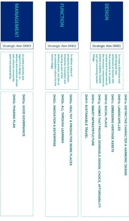
Figure 9.1: Strategic Aims and Objectives for Dunton Hills Garden Village
DHGV Policies
(45) POLICY R01 (i): Dunton Hills Garden Village Strategic Allocation
- In line with Policy SP02, land at Dunton Hills (east of the A128, south of the A127 and north of the C2C railway line, approximately 259.2 ha in size) is allocated for residential-led development to deliver Dunton Hills Garden Village.
- The development will deliver a mix of uses to comprise around 2,700 homes in the plan period (as part of an overall indicative capacity of around 4,000 homes to be delivered beyond 2033) together with the necessary community, employment, utility, transport and green and blue infrastructure (GBI) to support a self-sustaining, thriving and healthy garden village.
- Successful development of the site allocation will
require:
- the masterplan to be underpinned by Garden Community principles and qualities;
- proposals to creatively address the key site constraints and sensitively respond to the unique qualities and opportunities afforded by the historic landscape and environmental setting to deliver a distinctive and well-designed garden village in line with the Vision and Strategic Aims and Objectives for Dunton Hills Garden Village; and
- a holistic and comprehensive locally-led masterplan and design guidance to be developed, co-designed with relevant stakeholders to frame and guide the consistent quality and delivery across the site by different contractors over the delivery period.
- The proposed development will be required to deliver
all the necessary supporting spatial components and
infrastructure to address the specific site constraints,
potential impacts of development and harness the site
opportunities as set out by the strategic Dunton Hills aims
and objectives. Permission for mixed-use development will
be granted subject to the parameters and components
specified below:
- delivery of at least 2,700 dwellings in the plan period providing a balanced variety of housing typologies and tenure and includes provision of self-build plots in line with Policy HP01; specialist accommodation in line with Policy HP04; and affordable housing in line with Policy HP05. ;
- the provision of a minimum of 5 serviced Gypsy and Traveller pitches, in line with Policy HP07(b);
- land (5.5 ha) for employment space (in line with Policy PC03) to accommodate a creative range of employment uses suitable for a vibrant village centre and a predominantly residential area, including use class A1-A5 and appropriate B class uses.;
- land (circa 7.9 hectares) for a co-located secondary school (Use Class D1)
- land (circa 2.1 hectares each) for two co-located primary school and early years and childcare nurseries (Use Class D1)
- land (circa 0.13 hectares each) for two stand-alone early years and childcare nurseries (Use Class D1)
- community and health infrastructure proportional to the scale of development, and in line with best practice principles of healthy design;
- green and blue infrastructure to be a minimum of 50% of the total land area;
- retail provision to form the vibrant village core in the form of a 'District Shopping Centre' with additional Local Centre(s) in line with Policy PC08, as appropriate to the scale and phasing of the development.
- the provision of new and enhanced transport infrastructure to mitigate the impacts of development and to support sustainable modes of travel to ensure connectivity to key destinations, increase transport choice, support changes in travel behaviour, and to minimise the impact of traffic on the local and wider network, in line with Policy BE16 and as detailed in R01(ii) G-J;
- strategically designed and appropriately phased infrastructure, employing the most up to date technologies to ensure a smart, sustainable and a resilient basis for drainage and flood management in line with Policy BE08, water management including potable/ non-potable and opportunities for grey water harvesting in line with BE03, efficient and cost saving energy networks in line with Policy BE04, superfast broadband in line with Policy BE10.
(13) POLICY R01 (ii): Spatial design of Dunton Hills garden village
- The locally-led garden village will be developed collaboratively to achieve a high quality Dunton Hills Garden Village development. Consent for development will be permitted if the masterplan and supporting design guidance for the development demonstrate how the spatial vision, design principles as well as Policies HP12 - HP18 on securing high-quality of place-making is achieved to guide a coherent development across the whole allocation site.
Distinctive Character, Harmonic Design, Compact Density
- Proposals must demonstrate how they will meet and embed
key qualities to ensure distinctive, harmonic and popular
design is achieved, by ensuring:
- the unique character of Dunton Hills is informed by its distinct spatial, landscape and heritage qualities.
- the design of sub-neighbourhoods and streets, that may take on their own unique character, are harmoniously integrated to form an overall Dunton Hills Garden Village identity - through the coherent and complementary use of materials and design of the public realm in line with Policy HP18.
- an appropriate range of densities are achieved across the site to ensure a compact and highly networked, walkable and fine-grained environment with a highly connected street-based layout. This should be demonstrated by an accompanying density plan.
Ecological Networks, Biodiversity Net Gain, Green Infrastructure and Public Realm
- A green and blue infrastructure (GBI) plan should be
submitted that demonstrates how the design of GBI will be
an integral part of the masterplan layout to achieve
multi-functional, coherent and connected GBI in line with
Policy BE18. The GBI plan should be informed by a
comprehensive wildlife and habitat survey and heritage and
landscape character assessment. The GBI Plan should
incorporate the following:
- a highly connected and biodiverse ecological network that incorporates existing habitats of value and natural features, and where relevant new habitats such as trees, tree lines and hedges, hedgerows, ponds and lakes, among others, in line with Policy NE01, NE03 and NE04;
- a variety of activity nodes and treatments for recreation and leisure opportunities throughout the GBI, including public natural parkland, pockets of village greens, local nature reserve, allotment sites, sports pitches and fields;
- a streetscape that continues the green infrastructure through the residential areas and village centre with creative landscape schemes including tree-lined streets, grass verges and rain gardens;
- an appropriate amount and depth of green infrastructure screening adjacent to A127, A128, rail tracks to mitigate noise and air pollution;
- well-designed interfaces between the green open space and the built structures should ensure passive surveillance, with coherent and gradual transitions and clear boundaries and vistas; and
- a green infrastructure buffer / wedge on the eastern boundary with Basildon Borough to achieve visual separation to help significantly improve the landscaped and habitat value thus reinforcing the beneficial purpose and use of the green belt in that zone.
Sport, Recreational, Leisure and Public Open Space
- The provision for leisure, recreation and sport
opportunities must be an integral part of the GBI Plan; it
should incorporate as a minimum the following provision:
- an appropriate amount of sports and recreation provision to provide a variety of pitch sizes and facilities in line with Policy BE23;
- the GBI following Nightingale Lane should incorporate a heritage trail with signage and history information boards;
- pathways through the GBI network will be made of permeable material and follow a coherent treatment throughout the village. The pathways will all connect into a circular walk, with interconnected shortcut routes and be signposted offering directions to key destination points; and
- an appropriate number of play spaces shall be incorporated throughout the GBI network, with an emphasis on quality natural play provision to encourage outdoor adventure play and learning.
Views
- Key views shall be safeguarded and maintained and
become distinctive features on the development. This should
be informed by a key views assessment and proposals should
demonstrate the following:
- how the urban layout will incorporate safeguarded views in terms of the structure, morphology and how the streets and avenues are orientated to maintain the landscape corridors;
- how visual separation will be achieved on the eastern boundary of the site; and
- how the settlement orientations might also take advantage of opportunities for passive heating and cooling.
Embedding Heritage Assets
- Development should retain, integrate and where
appropriate enhance both designated and non-designated
heritage assets to provide an attractive and distinctive
garden village in line with Policies HP19, HP20 and HP22.
Incorporation of these assets should be informed by a
Landscape Character Assessment and Heritage Statement in
line with guidance, having key consideration for the
following provisions:
- protection and enhancement of existing public rights of way;
- the historic core and listed buildings of the farmstead are well integrated as part of the Dunton Hills Village Centre; and
- protection of listed buildings during the construction phase and during any retrofitting to ensure the structures are fit-for-purpose for new uses.
Sustainable Travel
- Priority should be given to cycle and pedestrian movements and access to public transport. Development should therefore, promote and incorporate sustainable transport measures in line with Policy BE12, Policy BE13, and Policy BE14. The development will be required to integrate 'Active by Design' measures throughout the street network to promote healthy travel options. The development will be required to incorporate a dedicated segregated cycle lane to ensure cycling is safe for all ages and to help discourage car use for short internal trips. Where appropriate, this should be integrated with the off-street cycle routes throughout the GBI network to ensure safe routes to schools and to other recreation facilities and key destinations.
Transport Impact Mitigations
- The development will be required to mitigate any
predicted transport impacts consistent with measures
identified in Policies BE11 and BE16. This should be
informed by the latest Transport Assessment, which should
be monitored and re-evaluated throughout the lifespan of
the build-out, to account for changes in transport
technology and wider strategic transport network changes.
As a minimum, mitigations will include:
- New junctions to access the garden village along with junction improvements where appropriate on the highway network, including any necessary traffic calming measures at key gateways, to create a sense of arrival;
- potential dedicated bus route(s) connecting the development with West Horndon station, nearby employment locations and other key social infrastructure;
- financial contribution to provide the necessary bus service to nearby school facilities prior to the delivery of on-site school facilities;
- improvements at West Horndon station for vehicular, segregated cycle and public transport access from surrounding developments as well as cycle storage and a bus interchange facility.
- illustrative plans to indicate key connections to the surrounding green infrastructure destinations and key nearby employment sites.
Clean Vehicle Alternatives
- The development should promote car-limiting and clean
vehicle alternatives in line with Policies BE12 and BE15.
Emphasis will be given to:
- incorporating car sharing clubs and electric vehicle only development;
- time limiting car parking in the central locations; and
- clean air zones around the main schools and community buildings.
Street Hierarchy
- The street hierarchy shall be designed to promote a
highly connected, permeable garden village that promotes
walking and cycling, yet accommodate the vehicular
accessibility requirements for servicing, refuse, emergency
access and bus routing. Proposals should demonstrate how
they are incorporating the following provisions:
- the development shall be a 20 mile an hour zone ensuring the safety of the public realm;
- main street(s) into the garden village from the main arterial routes (A127/A128) will adopt a tree-lined boulevard approach and be designed to slow down the traffic, making it clear that it is now a neighbourhood zone;
- enhancement of public footpaths, public rights of way routes (such as Nightingale Lane) and any bridleways throughout the GBI network, to coherently connect back to the residential pedestrian links; and
- residential streetscape should be designed to incorporate grass meridians, verges and trees/ tree lined avenues to help slow down the traffic and give the road an instant village feel.
Village Centre(s) – Retail, Community and Employment Opportunities
- Proposals for the placement and design of the village
centre(s) should be informed by an appropriate retail
hierarchy study that assesses village centre needs, based
on the supply and demand of the surrounding area. As a
minimum this should incorporate the following:
- the location of the main village centre should incorporate the historic farmstead in the centre of the site, creating a heritage legacy for the village centre;
- the village centre(s) should be designed to be mixed-use, with a range of commercial and community uses along ground floor frontages and a mix of uses on upper floors including residential and small-scale employment;
- the village centre(s) should provide localised opportunities for employment with a variety of work spaces, including flexible incubator/affordable spaces that are complementary to district-level service centre uses; and
- delivery of employment spaces should demonstrate a healthy-by-design approach, informed by leading industry guidance on the design of healthy and productive workplaces.
Social Infrastructure
- Proposals for the design of social infrastructure such
as schools, health facilities and community spaces must
demonstrate how they have incorporated key learning points
and knowledge from the interior design sectors to deliver
environments conducive to human health and social
wellbeing. Design proposals which demonstrate the following
will be supported:
- design informed by the latest knowledge and principles of human-centred design, biophilic design, and sustainable healthcare;
- design which demonstrates the adoption of relevant industry standards, such as BREAM or WELL standard; and
- facilities that are designed to be flexible to allow for wider community uses; for example, the use of the school in out-of-school hours for activities such as adult learning classes, other community activities, or the use of the school playing fields for community sports.
Delivery Approach and Legacy Management
(4) POLICY R01 (iii): Scheme Delivery and Legacy Management
Locally-led Garden Village
- As a locally-led garden village, the private sector
should work pro-actively and collaboratively with the
public sector to plan and design the masterplan and design
principles for the Dunton Hills site allocation. This will
require:
- community involvement to inform the design and delivery requirements from the outset; the approach should be outlined in a supporting Community Engagement Strategy; partnership working with key industry and public sector stakeholders is encouraged, especially to inform the evolution of the masterplan and determine the complex infrastructure requirements, in line with county level requirements; and
- implement of a Jobs Brokerage Scheme to ensure that new jobs created on site go to local people.
Development Phasing
- The development and phased delivery of DHGV must ensure the timely delivery of the required on-site and off-site infrastructure to address the impact of the new garden village and help the early establishment of a cohesive community. Proposals should be accompanied by a phasing plan to demonstrate how delivery will be phased, managed, accelerated and governed, without compromising quality.
Stewardship
- At the appropriate time, planning applications must include a supporting statement setting out the long-term sustainable governance and stewardship arrangements (management, maintenance and renewal) for the community assets including green-blue infrastructure, the public realm and community and other relevant facilities to be funded by the developer. Considerations should be given to devices such as legal covenants in deeds to establish responsibilities over certain matters of care, such as front gardens, communal gardens, public realm.
(1) 9.24 The sections that follow elaborate on the spatial vision and policy requirements. The vision for Dunton Hills Garden Village was defined following two Design Review workshops with Design Council CABE in 2016, as well as a broad analysis of site constraints and opportunities.
Distinctive Character & Harmonic Design
DISTINCTIVENESS
9.25 Strategic Objective DH01 (distinctive character & harmonic design) aligns to Garden Community principles which highlight qualities such as 'clear local identity', 'well designed', 'beautiful and imaginatively designed homes with gardens', 'clear identity'. Dunton Hills Garden Village should achieve a distinctive recognisable character by respecting the traditions of village life while ensuring 21st century conveniences, technologies and design. To achieve this aim requires a thorough understanding of the spatial context (landscape, heritage, habitat, constraints). The site's masterplan should creatively respond to the site's context. Achieving distinctiveness should be inspired by the historic evolution of Dunton Hills: the landscape character, heritage assets and cultural heritage references, such as local names, features, and their significance, in line with Strategic Objective DH01c (embedding heritage assets).
9.26 Design must also be informed by local aspirations, by inviting active participation of local community and stakeholders, as part of a coordinated and informed approach to masterplanning.
9.27 Historic garden villages placed a huge emphasis on the use of high-quality, craftsmanship and often local materials. This has resulted in homes and communities that have remained desirable and unique to their geographic context. How a place looks and feels tends to be the focus of objections to new communities establishing and therefore, it is important to get this right. We want Dunton Hills to become a community which sees itself as a 'conservation area of the future', not a dormitory 'non-place' that has become the norm for such developments in the recent past.
9.28 The development should incorporate the principles of design harmony (balance, symmetry, scale, proportions, etc.). Approaches such as 'building with nature' and 'healthy-by-design' should also be the starting point and embedded in the process of design to achieve a healthy, liveable, resilient and a self-sustaining new settlement. TCPA guidance on Garden Communities provides extensive learning points to guide the future creation of garden communities.
9.29 The design of the garden village must also consider how the place will feel to walk through at night as well, given the probable openness of its surroundings; night-time lighting will need to be designed in a way that provides the necessary levels of illumination, but not be detrimental to nocturnal wildlife.
DENSITY
(1) 9.30 The layout of the development should achieve a fine-grained, permeable and connected environment that makes the best, most efficient use of land. A new compact village vernacular should be defined that respects and maintains its feel as a village, but without the predominance of sprawling detached properties that do not make the best sustainable use of land and can often leave a place feeling exposed, incoherent, and car dominant. Development proposals should consider a density hierarchy that increases to medium density towards the local village centres and around public open spaces, to achieve a sense of enclosure and safety and natural surveillance overlooking exposed sites.
Homes
9.31 Strategic Objective DH01g (homes that provide desirable design, choice and are affordable) seeks to achieve homes people will be proud to live in, that are universal, adaptable and sustainable in design using quality durable materials and that are affordable and provide a range of choice in terms of size and tenure. This responds to the Garden Community principles which state the need to provide 'mixed-tenure homes', 'housing types that are genuinely affordable', 'great homes offering a range of high-quality distinctive homes'.
9.32 Delivering great, affordable homes will be key to making the village distinctive and desirable. At least 2,700 homes are planned within the Plan period, with an indicative capacity of around 4,000 to be delivered after 2033, subject to further feasibility and assessment of impact. Homes, like the public realm, should be well designed and provide a range of choice (dwelling sizes, tenure) to encourage a balanced community from all stages of life to form.
9.33 While houses should be designed to be distinctive, they must not be 'over designed', meaning that the traditional and much-loved elements of a house get distorted or become non-functional. At the same time development should avoid making Dunton Hills feel like dormitory non-place of sprawling, detached, cookie-cut houses that do not evoke any character or sense of pride, where traditional elements may have been included, but in a manner where the craftsmanship has neglected the detail to the extent that has rendered them undesirable, cheap-looking, slapdash and so often criticised of being 'pastiche' (but mean more likely a parody whereby the imitation falls short of the real thing).
9.34 The timely delivery of new homes will also be key to the early establishment and success of the new village. Proposals should demonstrate innovative ways to accelerate the delivery without compromising the quality, durability, longevity and overall sustainability of the built fabric.
9.35 A substantial fraction of the housing delivered on site should be genuinely affordable, and development proposals should think creatively about solutions to make this happen, learning from national and international case studies.
Landscape-Led
(1) URBAN LAYOUT / PUBLIC REALM
(1) 9.36 Strategic Objective DH01b (landscape-led) responds to the Garden Community principles that promote 'generous, accessible green space', 'development that enhances the natural environment', 'comprehensive green infrastructure network' and 'deliver environmental gains and enhancements to natural capital. At Dunton Hills this will be achieved through a landscape-led development with generous amount of green infrastructure for multi-functional uses. The landscape setting of Dunton Hills provides a unique backdrop to ensure green infrastructure (as well as the harmonious horizon views afforded by the topography of the site) is the starting point for the design response.
(1) 9.37 A design and build with nature approach delivers multiple benefits taking advantage of the wider ecosystem services and natural capital afforded by green infrastructure to achieve sustainable development: a). climate resilient infrastructure to counteract the impact of climate change and help achieve resource efficiency; b). multi-functional green spaces that are highly connected, accessible and incorporate universal design measures that encourage healthy recreation such as walking, cycling and horse riding, as well as other outdoor leisure and learning pursuits; c). a healthy public realm that creates a harmonious living environment. The green infrastructure proposals should deliver varied recreational experiences to appeal to a varied range of users with different interests and age-related preferences.
9.38 The public realm should focus on the importance of the street scene through attractive buildings, public art, street furniture, the use of materials, strong landscaping providing wide pavements and grass/planted verges, tree-lined avenues and where appropriate, incorporation of rain gardens and food production opportunities.
9.39 A highly connected network of streets should be designed, using existing field boundaries as a reference point to form an accessible, connected and fine-grained urban layout with neighbourhoods that are legible and easy to navigate, with a wide range of interlinked uses and generous green spaces, ensuring street blocks are contiguous and permeable to encourage walking and social interaction.
(1) 9.40 The significance of the landscape features and key views such as London skyline and Langdon Hills and others identified must be retained and enhanced as part of the development. Grassy meridians down the middle of streets should be used as a traffic calming tactic, especially on the larger roads which spur off the main A roads, to create lane separation for different transport modes.
BIODIVERSITY NET GAIN AND ECOLOGICAL CONNECTIVITY
9.41 The existing significant green infrastructure features such as the woodland, fenland and ponds should be retained and/or enhanced and connected to achieve a contiguous green corridor throughout the garden village, achieving biodiversity net-gain across the site.
9.42 As well as establishing an integrated ecological network within the site, the development should demonstrate its ecological connectivity to the wider 'living landscape' habitats and local wildlife destinations beyond the development boundary, for example Eastlands Spring, Thorndon Country Park to Langdon Hills Country Park. The site's existing habitats - such as the lakes and ponds - should inspire the basis for the design of parks and village greens as key destinations and nodes of social-cultural activity within the village, in line with DH01d (social place). Connecting these natural heritage assets gives structure to the site and naturally divides it into potentially varying character areas for development.
(1) 9.43 Proposals will need to retain and weave through priority habitats such as significant areas of existing woodland habitat; and where relevant, reinstate degraded fenland and demonstrate the measures taken to protect mature trees; and where appropriate, enhance hedgerows, ponds and other environmental features of note, which contribute to the character and biodiversity. The river course and ponds should be retained to minimise impact on the wildlife they support as well as contributing to sustainable drainage across the site.
9.44 The creative interweaving of productive landscapes within the GBI network will be favourably considered. The agricultural heritage of the site also provides a distinctive cultural context to inspire green infrastructure with a focus on food production and foraging as alternatives to grassed verges; while grass verges are well-loved in garden communities, alternatives or additional elements, such as sensory street verges through the use of, for example, culinary herbs or linear orchards could also add another dimension to the much-loved and expected tree-lined and green verge-lined residential avenues. Some allotments should be created for any residential properties which may not have a garden.
Embedding Heritage Assets
DESIGNATED & NON-DESIGNATED HERITAGE ASSETS
9.45 Strategic Objective DH01c (embedding heritage assets) aims to ensure the surviving historic features, notably the listed buildings, the wider farmstead barns and buildings, moated sites, field boundaries, historic woodland and parish boundaries which preserve elements of a probable medieval or earlier landscape as well as later settlement patterns will be preserved and enhanced. Successful places tend to also have a strong heritage identity. Heritage can provide a powerful connection between people and place. For this reason, heritage should be harnessed in a manner that will drive Dunton Hill's distinctiveness, health and well-being and place attachment. Garden Communities Prospectus places an emphasis on ensuring these 'communities… view themselves as the conservation areas of the future'. The prospectus also emphasises that development 'should include consideration for how the natural and historic environment of the local area is reflected and respected' to build a 'strong local vision'.
9.46 The farmstead shows that the farmhouse was the heart of the settlement, and that the existing large threshing barns to north and south of the main house were each part of larger courtyards and groupings of farm buildings. It was clearly a substantial farmstead throughout the eighteenth and nineteenth centuries, and the impressive scale and construction of the original threshing barns indicates that this was a wealthy and substantial farmstead for at least 100 years earlier. The surviving buildings within the landscape represent the typical medieval settlement pattern for this area and most are designated Grade II listed buildings.
9.47 The natural heritage of the landscape (including views) should be interconnected with the heritage of the listed buildings as well as other non-designated heritage assets of interest. The layout, orientation and morphology of the residential streets must be designed to enhance and highlight the key views (e.g. street axes towards the views, instead of buildings turning their backs onto them). As a minimum, the proposals should retain and incorporate this historic fabric.
9.48 Cultural references from the past, such as field patterns, field names and building names should inform the character and place-making aspects of the village. For example, heritage names such as Dunton Ridge, East Horndon Hall, as well as current hill names, given to the site by the golf players, should all inspire how the design of the village develops and how it could inform future street naming, neighbourhood naming, landmark naming.
9.49 While a preliminary desktop heritage assessment has highlighted these key heritage assets, proposals should be informed by a comprehensive Heritage Statement and Landscape Character Study, which should assess both the designated and non-designated heritage assets of the site.
9.50 Should any artefacts be found on site during construction, these should be recorded and safeguarded, with projects put in place to find a legacy home, including considerations as to how they can be incorporated as relics and public art in the village centre.
Sustainable & Clean Travel
ACTIVE TRAVEL
9.51 Strategic Objective DH01f (sustainable travel) seeks to ensure the development mitigates any road impacts resulting from the proposals and ensures development delivers sustainable travel options. The transport sector is innovating fast; and provision should, as far as appropriate, be planned to future proof transport needs. This objective responds to Garden Community principles which highlights the need for 'integrated, forward looking and accessible transport options' which facilitate access to jobs, education and services, where 'walking, cycling and public transport [is] designed to be the most attractive forms of local transport'. A Travel Plan should accompany an application to set out how sustainable travel will be achieved.
(1) 9.52 Starting from a blank canvas provides an opportunity to make streets like they do in many European cities, where cycling is the norm, rather than the exception. Principles of active design must guide the evolution of the village layout, street hierarchy and connectivity.
9.53 Planning for active travel must also consider the topography of the site, which will make this type of travel challenging for some. Innovative public transport schemes such as electric bikes should therefore be a considered option, providing appropriate locations for picking-up and dropping-off bikes.
9.54 Masterplan proposals will need to demonstrate how they are adhering to the creation of 'walkable neighbourhood's through the design of a highly networked street hierarchy, providing safe, segregated lanes for different modes of travel such as cycling and walking that are equitable to all users, minimising conflict of different modes and user abilities, thereby encouraging more to cycle and feel safe on the streets. These should integrate with 'quiet way' off-street options through green routes where possible.
9.55 The motor vehicle should be subordinate in importance on the street network within the village. Equally, while a car-limited development should be the main driver, the development should also make owning or using clean vehicle options possible, taking advantage of the latest and emerging technologies.
9.56 The necessary electric vehicle charging infrastructure should also be designed and delivered appropriately, adhering to principles of universal design and clutter free public realm. Vehicle sharing clubs should be encouraged to establish. These less polluting vehicle options should be coupled by planning for clean air zones/car free, especially around the schools.
9.57 Design should consider how to influence safe and active travel mode behaviours through design, i.e. streets narrow and 'village' in feel, dense network of streets, paths and parks ensures that it is faster and more enjoyable to walk and bike than to drive, less land to streets.
9.58 Cul-de-sacs should be an exception; street width is important to allow cycling and not allow the car to dominate, making them pedestrian friendly with opportunities for home zones to establish.
Social Place
VILLAGE CENTRE
9.59 Strategic Objective DH01d (social place) seeks to ensure the development creates active, vibrant village centres with the necessary community infrastructure, all connected and interspersed by nodes of social-cultural activity and recreational opportunities throughout the green infrastructure to foster social wellbeing and healthy communities. This aligns to the Garden Community principles which state that development should deliver 'strong cultural, recreational and shopping facilities' and where the 'scale… supports the necessary infrastructure to allow the community to function self-sufficiently on a day-to-day basis'. Additionally, it states that Garden Communities should be 'healthy places', 'designed to provide the choices and changes for all to live a healthy life'.
(1) 9.60 The long-term success of any place is fundamentally rooted in the community that establishes; and this invariably depends on designing places that are social, that incorporate spaces where opportunities for recreation, social interaction and where individual and collective wellbeing pursuits can ensue. For Dunton Hills, the historic fabric of the farmstead already provides an ideal, cultural heritage backdrop for the primary village centre to establish itself with a village green and a mix of civic and commercial spaces to create a vibrant village core.
9.61 Knitting together the residential streets with the village centre(s) will be the green infrastructure, which will be interspersed with nodes of recreation/leisure activity and more local village hubs, making the whole village feel connected and walkable in line with DH01b (landscape-led).
9.62 The village centre should be on the District Shopping Centre level in the retail hierarchy, comparable with Ingatestone village centre, to create a central hub for new residents to come together and to provide day-to-day facilities including a supermarket, retail, healthcare, leisure and community amenities. The amount of retail is to be confirmed through the masterplan process.
SOCIAL INFRASTRUCTURE
9.63 The timely delivery of education, health and community facilities early in the development will also be key to enabling the success of the village in its early years. Community spaces should be flexible to adapt to the needs and cultural preferences of the community which settles.
9.64 Opportunities to co-design these spaces with the surrounding communities and/or with early settlers should be harnessed.
9.65 A health facility will need to be part of the community infrastructure, and this should be carefully planned to ensure the integration encourages better, healthier behaviours. The facility should focus on wellbeing and prevention, and be an exemplar example of integrating diagnosis, treatment and proactive wellbeing onsite, set in a backdrop of nature, where prescribing healthy activity can be achieved by the integration of services. Integrating the health facility in proximity to recreation and community facilities will actively encourage 'sustainable healthcare', embedding a design that encourages healthy living, eating, and activities and opportunities for social prescribing.
9.66 Design principles for community and health facilities should incorporate:
- the principles set out by the Centre for Sustainable Health Care including: prevention, patient empowerment and self-care, lean systems, low carbon alternatives;
- principals of biophilic design which connect people with nature and use design elements which incorporate natural analogues (such as natural textures, patterns, colours and images) to create positive perceptual environments.
Smart Infrastructure
9.67 Strategic Objective DH01e (smart infrastructure) seeks to ensure development delivers smart, sustainable and resilient infrastructure to future-proof investment. This objective aligns to the Garden Community principles which calls for 'future proofed' places, designed to be resilient to allow for changing demographics, future growth and the impacts of climate change; as well as development that 'uses zero-carbon and energy-positive technology to ensure climate resilience'. This is fundamental to a development site that will take over two decades to complete.
9.68 It is important that the infrastructure is creatively designed to take account of the anticipated opportunities presented by technological advances (such as driverless cars and renewable energy measures), therefore, ensuring some flexibility to adapt to future progression. Sustainable development can only be achieved through the use of cleaner, smarter, more energy efficient service infrastructure that save on running costs in the longer-term. Smart infrastructure should look at the best possible solutions to minimise resource waste and costs, and maximise efficiencies, value for money and digital convenience.
9.69 Digital infrastructure will be fundamental, especially to account for the changing working patterns and needs for home working.
9.70 Future proofing investment can be achieved by taking advantage of land value capture which is made possible by green field development at these early stages – a key Garden Communities principle. It is important to recognise the fundamental role that GBI can play in delivering climate resilient smart infrastructure to help achieve resource efficiencies in water management, energy consumption as well as mitigation of air pollution.
9.71 Opportunities to embed anticipated technological advances must be secured early in the design and build of the scheme. There are many examples of how smart infrastructure is being rolled out throughout the world; these should be taken into account in a scheme like this which will be 20 years into the future; opportunities such as driverless public transport, construction techniques that allow for accelerated delivery, building and construction materials that generate energy, smart grids that are more efficient at utilising energy, ambitious standards for environmental sustainability of housing, and undergrounding of refuse bins, etc. should all be considerations in the planning and design of the scheme, subject to further masterplanning work.
Enterprise, Innovation and Learning
(1) 9.72 Strategic Objective DH02b (all through learning) will deliver an exemplar all through school with a design that fosters a learning environment for all types of learners and through life, from nursery through to adult learning opportunities.
9.73 Garden Community principles emphasise the need to integrate 'a wide range of jobs within easy commuting distances of homes'. The success of enterprise depends on designing and building work places and learning spaces that are healthy-by-design, to inspire and promote creativity and productivity.
9.74 Strategic Objective DH02c (innovation & learning) aims to ensure the construction process quick-starts a programme of innovation, learning and enterprise; and Strategic Objective DH02a (healthy & productive work places) seeks to ensure the delivery of a variety of workplaces to ensure a self-sustaining garden village with good job opportunities.
9.75 Dunton Hills is being developed amongst a backdrop of wider economic growth opportunities, including the Enterprise Park and East Horndon employment site. The proximity of these workplaces will make Dunton Hills Village a desirable place to live, to be near work.
9.76 Equally however, the village centre(s) themselves should provide opportunities for localised employment, to ensure a thriving local economy ensues. The spaces should be designed to flexibly accommodate A1-A5 use classes as well as appropriate B1 uses and other community spaces, thinking particularly about the entrepreneurial potential of the area.
9.77 The interior design should be informed by the latest research and guidance from key institutional bodies like British Council of Offices (BCO) and Chartered Institute of Building Services Engineering (CIBSE) on how design can create productive workplaces. The aspiration is to also create units that are suitable for small businesses as well as account for the current trend in flexible working modes; superfast broadband will be integral in all buildings to make this a success.
9.78 This aim also requires a programme of complementary actions to be embedded alongside the planning process, such as working with the research and innovation sectors and local education establishments, to ensure knowledge transfer and learning are firmly embedded from conception, through to construction and implementation of the scheme.
9.79 Delivery of, firstly, primary, and eventually, secondary education provision is key to the long-term success of the village. Its location and how it is designed is also fundamental to the overall performance of the school. The school should ideally be placed away from the main arterial roads that surround the site, and should be orientated towards the village centre, so that it becomes part of the social fabric of the place and creates opportunities for wider after-school recreation and learning pursuits by the wider community.
9.80 The school should be set within a garden itself, providing opportunities for outdoor learning and 'forest school' sessions in nature. It should also provide the on-site provision of playing fields for sports and physical education. The interior and functional design of the school should be informed by various case studies which have learned from successes and failures of makeing a good learning environment (e.g. schools for future programmes). Designing for sensory comfort and stimulation are fundamental components of interior design and particular attention should be placed on issues of solar gains, ventilation, air quality and movement through school. Implementation of accredited standards, such as the WELL standard will be expected.
9.81 The project team have already begun a programme working with local schools and universities. This is instilling a culture of co-design, which could eventually lead to a cultural of co-delivery within the community. Such initiatives can help foster a sense of community and achievement, and drive a sense of belonging to the place.
(1) 9.82 The construction programme should create a programme of apprenticeships to inspire future residents to be part of the process and should, where appropriate, incorporate elements of traditional skills and craftsmanship. Additional learning programmes could be implemented such as involving local schools and education establishments to help monitor and record any wildlife and changes as part of the school curriculum, establishing learning opportunities from the outset.
Community Stewardship
9.83 Strategic Objective DH03a (governance) aims to ensure development embeds the right governance structures and covenants to maintain an ongoing and proactive stewardship of communal and public interfacing spaces. This responds to the fundamental Garden Communities principle of 'community ownership of land and long-term stewardship of assets'.
9.84 A suitable management body will need to be established at an appropriate time to manage the assets of the DHGV over the long-term. The most suitable approach should emerge through the design and delivery process. Consideration should be given to how the legacy assets will be handed over for on-going legacy operations and maintenance.
9.85 To achieve this aim requires the early thinking about the handover and legacy requirements of the development. The delivery process should firmly embed principles of co-creation and participation. Embedding these requirements early will help the self-sufficiency of the site, providing the longer-term environment for a more effective resource management approach as well as a spirit of active citizenship, participation and stewardship of the village assets.
9.86 Development proposals should demonstrate how ongoing management is to be achieved in line with the key Garden Communities principle on legacy and stewardship arrangements. Active participation in the design and delivery will foster a sense of belonging and continued participation in the village life and stewardship of assets. The setup of such arrangements are to be funded by the development from the outset.
9.87 A delivery and legacy management strategy should be developed, in collaboration with development management, local authority departments (highways, planning, property), the Parish Council, utility service providers, land trusts, to find the best model to achieve the desired outcome, without a long-term disproportionate and unsustainable financial burden on any one stakeholder group.
9.88 Equally, thinking creatively about land registry solutions, such as creating covenants to achieve key stewardship elements for the maintenance of front of house green verges, or treatment of front gardens, for example, should be considered.
9.89 The Legacy Management Strategy should include the elements of logistics, project management, governance arrangements, code of construction, amongst others, to give assurance around the deliverability of the scheme, within a timely manner.
(5) Strategic Housing Allocations
(2) West Horndon Industrial Estate
(25) POLICY R02: Land at West Horndon Industrial Estate
Land at West Horndon Industrial Estate, as shown in Appendix 2, is allocated for residential development. Development proposals should consider the following:
- Amount and Type of Development
- provision for around 580 new homes of mixed size and type, including affordable housing;
- provision for a residential care home (around 60 bed scheme as part of the overall allocation);
- provision for 5% self-build and custom build across the entire allocation area; and
- Provision of 2ha of land for employment purposes.
- Development Principles
- comprehensive masterplan and phasing strategy to be prepared and considered as planning application comes forward;
- vehicular access via Station Road and Childerditch Lane;
- creating a new village centre, connected by sustainable links to West Horndon station, and which comprises retail and supporting community facilities;
- new and enhanced links with West Horndon station and the wider area; and
- provide well-connected internal road layouts which allow for good accessibility;
- provision for new multi-functional green infrastructure, including public open space.
- provide for appropriate landscaping and buffers along sensitive boundary adjoining the railway line.
- Infrastructure Requirements
- provision for improved bus service;
- provision for health facilities; and
- the site is located within a Critical Drainage Area. This development may have the potential to impact on the Critical Drainage Area in respect of surface water flooding. As a result of this, the site is likely to require an individually designed mitigation scheme to address this issue.
9.90 This site is situated on the western side of West Horndon adjoining the railway station in the centre of the village. The site will provide for around 580 homes, anticipated to be delivered between 2021/22 and 2030/31. This will deliver a high quality sustainable new development that maximises opportunities for travel by sustainable modes. It will provide a mix of size and type of homes including affordable, self-build and custom build, appropriately accessible and adaptable housing, as well as other types of specialist housing in accordance with the Council's policy requirements.
(1) 9.91 The development will take its main vehicular access from Station Road and will be expected to adequately mitigate its likely impacts on the performance of the local and strategic road network.
9.92 This development is in close proximity to the existing village and well located to existing facilities including the train station, shop, public house and village hall.
9.93 Opportunities for sustainable transport modes should be maximised to allow for alternative forms of transport to the private car (walking, cycling and public transport) are prioritised.
9.94 A residential travel plan will be required for the development to include a package of measures to ensure active and sustainable means of travel are available to all new residents, to promote the benefits of sustainable transport and secure a modal shift from the private car. The development will be required to provide good accessibility for bus services and improve nearby bus stop infrastructure.
9.95 The development is expected to promote the highest standards of design to ensure inclusive and high-quality buildings and spaces.
9.96 The development will be required to provide appropriate landscaping and buffers to preserve the amenity of adjoining residential properties. Buffers will also be required along sensitive boundaries adjoining the railway line.
(1) 9.97 As the site is located within a Critical Drainage Area early consultation with the Lead Local Flood Authority (Essex County Council) will be required to determine appropriate mitigation which should be incorporated into the overall design of the scheme.
Land North of Shenfield, Shenfield
(15) POLICY R03: Land North of Shenfield
Land north of Shenfield, as shown in Appendix 2, known as Officer's Meadow and surrounding land is allocated for residential development. Development proposals should consider the following:
- Amount and Type of Development
- provision for around 825 new homes of mixed size and type, including affordable housing;
- provision of land (circa 2.1 hectares) for a co-located primary school and early years and childcare nursery (Use Class D1);
- provision for a residential care home (around 60 bed scheme as part of the overall allocation);
- provision for 5% self-build and custom build across the entire allocation area; and
- provision of 2ha of land for employment purposes.
- Development Principles
- comprehensive masterplan and phasing strategy to be prepared and considered as planning applications come forward;
- site is identified as a key gateway location and development should reflect this in terms of design quality particularly on land near to Junction 12, A12;
- vehicular access via Chelmsford Road (A1023) and Alexander Lane;
- potential for diversion of Alexander Lane, creating a quiet lane for pedestrians and cyclists, with the provision for new and improved route through the development site linking to Chelmsford Road;
- enhancing sustainable links with Shenfield station and local services and facilities in the wider area;
- provide well-connected internal road layouts which allow for good accessibility;
- provision for new multi-functional green infrastructure including public open space;
- maintain and enhance Public Right of Way within the site and to the wider area; and
- protect and where appropriate enhance the Local Wildlife Site (Arnold's Wood).
- provide for appropriate landscaping and buffers along sensitive boundaries adjoining the A12 and railway line.
- Infrastructure Requirements
- provide pedestrian and cycle crossing points across Chelmsford Road (A1023) where appropriate;
- provision for improved bus service; and
- the site is located within a Critical Drainage Area. This development may have the potential to impact on the Critical Drainage Area in respect of surface water flooding. As a result of this, the site is likely to require an individually designed mitigation scheme to address this issue.
(1) 9.98 This site is situated to the north of Shenfield with the A12 adjoining the northern boundary and railway line to the east. The site will provide for around 825 homes, anticipated to be delivered between 2023/24 and 2030/31. This will deliver a high quality sustainable new development that maximises opportunities for travel by sustainable modes. It will provide a mix of size and type of homes including affordable, self-build and custom build, appropriately accessible and adaptable housing, as well as other types of specialist housing in accordance with the Council's policy requirements.
9.99 As the allocation comprises a number of parcels which could be brought forwards at different times it is important that consideration is given to how the site will develop holistically. As individual parcels are brought forwards any masterplan will need to appropriately consider and reflect what is being proposed elsewhere on the site. This is particularly important in ensuring that collective requirements for infrastructure provision are considered and delivered appropriately.
(1) 9.100 Given the scale of development, a wide range of new community services and facilities including a new co-located primary school and early years and childcare nursery, open space and play facilities are required. These services and facilities should be of an appropriate scale to serve the new communities and located where they will be easily accessible by walking, cycling and public transport to the majority of residents in the development.
9.101 The scale of development in this location will require a new primary school with co-located early years and childcare nursery located on 2.1ha of land. A comprehensive approach will be necessary to deliver this early on in the development.
9.102 The development will take its main vehicular access from Chelmsford Road (A1023) and will be expected to adequately mitigate its likely impacts on the performance of the local and strategic road network.
9.103 Opportunities for sustainable transport modes should be maximised to create neighbourhoods where alternative forms of transport to the private car (waking, cycling and public transport) are prioritised. New and enhanced pedestrian and cycle connections will be expected to be provided within the site and to the wider area. As parts of the site are separated by Chelmsford Road (A1023) pedestrian and cycle crossings need to be provided where appropriate to allow for safe connection between the two areas. Opportunities to improve and enhance pedestrian and cycle connectivity with Shenfield station, local services and shops should also be explored.
9.104 A residential travel plan will be required for the development to include a package of measures to ensure active and sustainable means of travel are available to all new residents, to promote the benefits of sustainable transport and secure a modal shift from the private car. The development will be required to provide good accessibility for bus services and improve nearby bus stop infrastructure.
(1) 9.105 The development will be required to provide appropriate habitat mitigation and creation, and appropriate buffers to the Local Wildlife Site (Arnold's Wood). As the site is located within a Critical Drainage Area early consultation with the Lead Local Flood Authority (Essex County Council) will be required to determine appropriate mitigation which should be incorporated into the overall design of the scheme.
Ford Headquarters and Council Depot, Warley
(8) POLICY R04 and R05: Ford Headquarters and Council Depot
The Ford Headquarters and Council Depot, Warley, as shown in Appendix 2, is allocated for residential development. Development proposals should consider the following:
- Amount and Type of Development
- provision for around 473 new homes of mixed size and type, including affordable housing;
- provision for a residential care home (around 60 bed scheme as part of the overall allocation);
- provision for 5% self-build and custom build across the entire allocation area; and
- provision of 2ha of land for employment purposes.
- Development Principles
- comprehensive masterplan and phasing strategy to be prepared and considered as planning applications come forward;
- vehicular access via Eagle Way and The Drive;
- provide well-connected internal road layouts which allows for good accessibility;
- integrate existing community facilities within new development provision for new multi-functional green infrastructure including public open space;
- consideration of historic context for the area;
- preserve the setting of two listed buildings on adjoining land to the west; and
- protect and where appropriate enhance the Local Wildlife Sites (Barrack Wood/Donkey Lane Plantation).
- Infrastructure Requirements
- provision for improved bus service; and
- the site is located within a Critical Drainage Area. This development may have the potential to impact on the Critical Drainage Area in respect of surface water flooding. As a result of this, the site is likely to require an individually designed mitigation scheme to address this issue.
9.106 This site is situated to the south of the Warley urban area. The site will provide for around 473 homes, anticipated to be delivered between 2024/25 and 2032/33. This will deliver a high quality sustainable new development that maximises opportunities for travel by sustainable modes. It will provide a mix of size and type of homes including affordable, self-build and custom build, appropriately accessible and adaptable housing, as well as other types of specialist housing in accordance with the Council's policy requirements.
9.107 The development will take its main vehicular access from Eagle Way and The Drive and will be expected to adequately mitigate its likely impacts on the performance of the local and strategic road network.
(1) 9.108 It is expected that existing community facilities adjoining the site (e.g. Brentwood Imperial Youth Band) will be integrated into the development.
9.109 A residential travel plan will be required for the development to include a package of measures to ensure active and sustainable means of travel are available to all new residents, to promote the benefits of sustainable transport and secure a modal shift from the private car. The development will be required to provide good accessibility for bus services and improve nearby bus stop infrastructure.
9.110 The historic context of the site including previous use by the Essex Regiment and current use by Ford Motor Company provides an opportunity to promote local history.
9.111 The development will be required to provide appropriate habitat mitigation and creation, and appropriate buffers to the Local Wildlife Site, Barrack Wood/Donkey Lane Plantation.
(1) 9.112 As the site is located within a Critical Drainage Area early consultation with the Lead Local Flood Authority (Essex County Council) will be required to determine appropriate mitigation which should be incorporated into the overall design of the scheme.
(31) Housing Allocations
Land off Nags Head Lane, Brentwood
(5) POLICY R06: Land off Nags Head Lane
Land off Nags Head Lane, Brentwood, as shown in Appendix 2, is allocated for housing development. Development proposals should consider the following:
- Amount and Type of Development
- provision for around 125 new homes of mixed size and type.
- Development Principles
- vehicular access via Nags Head Lane;
- provision for pedestrian and cycle connections
- provision for public open space; and
- provide for sensitive landscaping along the north and eastern boundaries adjoining existing commercial development and residential dwellings;
- Infrastructure Requirements
- the site is located within a Critical Drainage Area. This development may have the potential to impact on the Critical Drainage Area in respect of surface water flooding. As a result of this, the site is likely to require an individually designed mitigation scheme to address this issue.
9.113 This site is situated to the west of the Brentwood urban area bounded by the railway line and Nags Head Lane. Residential properties and retail units adjoin the site to the north and further residential properties adjoin the eastern boundary. The site will provide for around 125 homes, anticipated to be delivered between 2021/22 and 2025/26. It will provide a mix of size and type of homes including affordable in accordance with the Council's policy requirements.
9.114 The development will take its main vehicular access from Nags Head Lane and will be expected to adequately mitigate its likely impacts on the performance of the local and strategic road network.
(1) 9.115 Residential Travel Information Packs would be expected to be provided to new residents to promote sustainable travel from the site. These should be produced in consultation with the Highway Authority.
(2) 9.116 As the site is located within a Critical Drainage Area early consultation with the Lead Local Flood Authority (Essex County Council) will be required to determine appropriate mitigation which should be incorporated into the overall design of the scheme.
Sow and Grow Nursery, Pilgrims Hatch
(51) POLICY R07: Sow and Grow Nursery
Sow and Grow Nursery, Pilgrims Hatch, as shown in Appendix 2, is allocated for housing development. Development proposals should consider the following:
- Amount and Type of Development
- provision for around 38 new homes of mixed size and type, including affordable housing.
- Development Principles
- vehicular access via Ongar Road;
- provision for pedestrian and cycle connections;
- preserve the setting of the Historic Park and Garden site (South Weald Park) to west of the site; and
- provide for sensitive landscaping along the south western boundary adjoining the allotments.
- Infrastructure Requirements
- the site is located within a Critical Drainage Area. This development may have the potential to impact on the Critical Drainage Area in respect of surface water flooding. As a result of this, the site is likely to require an individually designed mitigation scheme to address this issue.
9.117 This site is situated to the south west of Pilgrims Hatch on off Ongar Road (A128). Residential properties are situated to the north and on the opposite side of Ongar Road (A128). Allotments and agricultural fields adjoin the site to the west. The site will provide for around 38 homes, anticipated to be delivered between 2020/21 and 2021/22. It will provide a mix of size and type of homes including affordable in accordance with the Council's policy requirements.
9.118 The development will take its main vehicular access from Ongar Road (A128) and will be expected to adequately mitigate its likely impacts on the performance of the local and strategic road network.
9.119 Residential Travel Information Packs would be expected to be provided to new residents to promote sustainable travel from the site. These should be produced in consultation with the Highway Authority.
9.120 The development will be required to provide appropriate landscaping and buffers to protect the amenity of the adjoining allotments and nearby Historic Park and Garden at South Weald Park.
(1) 9.121 As the site is located within a Critical Drainage Area early consultation with the Lead Local Flood Authority (Essex County Council) will be required to determine appropriate mitigation which should be incorporated into the overall design of the scheme.
(4) POLICY R08: LAND AT Mascalls Lane
Land at Mascalls Lane, Warley, as shown in Appendix 2, is allocated for housing development. Development proposals should consider the following:
- Amount and Type of Development
- provision for around 9 new homes of mixed size and type.
- Development Principles
- vehicular access via Mascalls Lane; and
- provide for sensitive landscaping along the north, east and western boundaries adjoining existing residential dwellings.
- Infrastructure Requirements
- the site is located within a Critical Drainage Area. This development may have the potential to impact on the Critical Drainage Area in respect of surface water flooding. As a result of this, the site is likely to require an individually designed mitigation scheme to address this issue.
9.122 This site is situated to the south of Warley on land off Mascalls Lane. Existing residential properties adjoin the site on the north, east and western boundaries. The site will provide for around 9 homes, anticipated to be delivered in 2020/21.
9.123 The development will take its main vehicular access from Mascalls Lane and will be expected to adequately mitigate its likely impacts on the performance of the local and strategic road network.
9.124 Residential Travel Information Packs would be expected to be provided to new residents to promote sustainable travel from the site. These should be produced in consultation with the Highway Authority.
(1) 9.125 As the site is located within a Critical Drainage Area early consultation with the Lead Local Flood Authority (Essex County Council) will be required to determine appropriate mitigation which should be incorporated into the overall design of the scheme.
(3) POLICY R09: Land off Warley Hill
Land off Warley Hill, Warley, as shown in Appendix 2, is allocated for housing development. Development proposals should consider the following:
- Amount and Type of Development
- provision for around 43 new homes of mixed size and type.
- Development Principles
- vehicular access via Pastoral Way; and
- preserve the setting of nearby listed buildings;
- provide for sensitive landscaping throughout the site and consider the need for the retention of some existing trees on site where appropriate.
- Infrastructure Requirements
- the site is located within a Critical Drainage Area. This development may have the potential to impact on the Critical Drainage Area in respect of surface water flooding. As a result of this, the site is likely to require an individually designed mitigation scheme to address this issue.
9.126 This site is situated near the centre of Warley on land west of Warley Hill (B186) to the south of Warley on land off Mascalls Lane. Residential properties lie to the north east and north west of the site with established woodland adjoining the western boundary. The site will provide for around 43 homes, anticipated to be delivered between 2023/24 and 2024/25. It will provide a mix of size and type of homes including affordable in accordance with the Council's policy requirements.
9.127 The development will take its main vehicular access from Pastoral Way. Development will be expected to adequately mitigate its likely impacts on the performance of the local and strategic road network.
9.128 Residential Travel Information Packs would be expected to be provided to new residents to promote sustainable travel from the site. These should be produced in consultation with the Highway Authority.
9.129 The site forms part of the former Warley Hospital estate with nearby Grade II Listed Buildings situated to the north (Tower House and Lodge at Warley Hospital). The setting of these will need appropriate consideration in forming the design and layout of the site.
(1) 9.130 As the site is located within a Critical Drainage Area early consultation with the Lead Local Flood Authority (Essex County Council) will be required to determine appropriate mitigation which should be incorporated into the overall design of the scheme.
Brentwood Railway Station car park, Brentwood
(8) POLICY R10: Brentwood Railway Station car park
Brentwood Railway Station car park, as shown in Appendix 2, is allocated for housing development. Development proposals should consider the following:
- Amount and Type of Development
- provision for around 100 new homes of mixed size and type, including affordable housing.
- Development Principles
- vehicular access via St. James Road;
- provision for pedestrian and cycle connections
- provision for public open space;
- development proposals should consider wider Town Centre parking needs in collaboration with other development sites where there is existing parking on site, in order to ensure that the current level of Town Centre public parking spaces is maintained.
- Infrastructure Requirements
- the site is located within a Critical Drainage Area. This development may have the potential to impact on the Critical Drainage Area in respect of surface water flooding. As a result of this, the site is likely to require an individually designed mitigation scheme to address this issue.
9.131 This site is situated in Brentwood on land west of Brentwood railway station. The site is bounded by the railway line to the south and there are residential dwellings situated to the north. The site will provide for around 100 homes, anticipated to be delivered between 2029/30 and 2032/33. It will provide a mix of size and type of homes including affordable in accordance with the Council's policy requirements.
9.132 The development will take its main vehicular access from St James Road and will be expected to adequately mitigate its likely impacts on the performance of the local and strategic road network.
9.133 Residential Travel Information Packs would be expected to be provided to new residents to promote sustainable travel from the site. These should be produced in consultation with the Highway Authority.
9.134 With the site being centrally located opportunities to create improved connections and public realm enhancement, including the creation of public open space should be maximised.
9.135 Opportunities for sustainable transport modes should be maximised to allow for alternative forms of transport to the private car (walking, cycling and public transport) to be prioritised.
(1) 9.136 As the site is located within a Critical Drainage Area early consultation with the Lead Local Flood Authority (Essex County Council) will be required to determine appropriate mitigation which should be incorporated into the overall design of the scheme.
Westbury Road Car Park, Brentwood
(5) POLICY R11: Westbury Road Car Park
Land off Westbury Road, Brentwood, as shown in Appendix 2, is allocated for housing development. Development proposals should consider the following:
- Amount and Type of Development
- provision for around 45 new homes of mixed size and type, including affordable housing.
- Development Principles
- vehicular access via Westbury Road;
- site is identified as a key opportunity area within the Town Centre Design Plan and development should reflect this in terms of design quality;
- provision for pedestrian and cycle connections;
- preserve and where appropriate enhance the character and appearance of the Conservation Area which adjoins the site.
- preserve the setting of nearby listed buildings;
- heritage assessment taking account of archaeological potential for the historic core of Brentwood; and
- development proposals should consider wider Town Centre parking needs in collaboration with other development sites where there is existing parking on site, in order to ensure that current level of Town Centre public parking spaces is maintained.
- Infrastructure Requirements
- the site is located within a Critical Drainage Area. This development may have the potential to impact on the Critical Drainage Area in respect of surface water flooding. As a result of this, the site is likely to require an individually designed mitigation scheme to address this issue.
9.137 This site is located within Brentwood Town Centre on land south of the High Street (A1023) and west of Kings Road. Residential properties adjoin the southern boundary and business uses lie to the east. The site will provide for around 45 homes, anticipated to be delivered between 2020/21 and 2021/22. It will provide a mix of size and type of homes including affordable in accordance with the Council's policy requirements.
9.138 The development will take its main vehicular access from Westbury Road and will be expected to adequately mitigate its likely impacts on the performance of the local and strategic road network.
9.139 Residential Travel Information Packs would be expected to be provided to new residents to promote sustainable travel from the site. These should be produced in consultation with the Highway Authority.
9.140 The site is situated in an important central location in within Brentwood Town Centre. Appropriate consideration therefore needs to be given to preservation and where appropriate enhancing the nearby Conservation Area and setting of Listed Buildings.
(1) 9.141 As the site is located within a Critical Drainage Area early consultation with the Lead Local Flood Authority (Essex County Council) will be required to determine appropriate mitigation which should be incorporated into the overall design of the scheme.
Land at Hunter House, Brentwood
(6) POLICY R12: Land at Hunter House
Land at Hunter House, as shown in Appendix 2, is allocated for housing development. Development proposals should consider the following:
- Amount and Type of Development
- provision for around 48 new homes of mixed size and type, including affordable housing.
- Development Principles
- vehicular access via Western Road;
- provision for pedestrian and cycle connections; and
- heritage assessment taking account of archaeological potential for the historic core of Brentwood.
Infrastructure Requirements
- the site is located within a Critical Drainage Area. This development may have the potential to impact on the Critical Drainage Area in respect of surface water flooding. As a result of this, the site is likely to require an individually designed mitigation scheme to address this issue.
(1) 9.142 This site is located within Brentwood Town Centre on land adjacent to Western Road, south of William Hunter Way and the western end of the High Street (A1023). The site is adjoined by residential dwellings and commercial premises on all boundaries. The site will provide for around 48 homes, anticipated to be delivered between 2024/25 and 2026/27. It will provide a mix of size and type of homes including affordable in accordance with the Council's policy requirements.
(1) 9.143 The development will take its main vehicular access from Western Road and will be expected to adequately mitigate its likely impacts on the performance of the local and strategic road network.
9.144 Residential Travel Information Packs would be expected to be provided to new residents to promote sustainable travel from the site. These should be produced in consultation with the Highway Authority.
(1) 9.145 As the site is located within a Critical Drainage Area early consultation with the Lead Local Flood Authority (Essex County Council) will be required to determine appropriate mitigation which should be incorporated into the overall design of the scheme.
Chatham Way car park, Brentwood
(7) POLICY R13: Chatham Way Car Park
Chatham Way car park, Brentwood, as shown in Appendix 2, is allocated for housing development. Development proposals should consider the following:
- Amount and Type of Development
- provision for around 31 new homes of mixed size and type, including affordable housing.
- Development Principles
- vehicular access via Chatham Way;
- provision for pedestrian and cycle connections;
- possible retention of public car parking along with Westbury Road and William Hunter Way Housing sites;
- preserve and where appropriate enhance the character and appearance of the Conservation Area which the site is situated within;
- heritage assessment taking account of archaeological potential for the historic core of Brentwood; and
- development proposals should consider wider Town Centre parking needs in collaboration with other development sites where there is existing parking on site, in order to ensure that the current level of Town Centre public parking spaces is maintained.
- Infrastructure Requirements
- the site is located within a Critical Drainage Area. This development may have the potential to impact on the Critical Drainage Area in respect of surface water flooding. As a result of this, the site is likely to require an individually designed mitigation scheme to address this issue.
9.146 This site is located within Brentwood Town Centre on land between Chatham Way and Crown Street at the western end of the High Street (A1023). The site is adjoined by residential dwellings and commercial premises on all boundaries. The site will provide for around 31 homes, anticipated to be delivered between 2020/21 and 2021/22. It will provide a mix of size and type of homes including affordable in accordance with the Council's policy requirements.
9.147 The development will take its main vehicular access from Chatham Way. It will be expected to adequately mitigate its likely impacts on the performance of the local and strategic road network.
9.148 Residential Travel Information Packs would be expected to be provided to new residents to promote sustainable travel from the site. These should be produced in consultation with the Highway Authority.
(1) 9.149 As the site is located within a Critical Drainage Area early consultation with the Lead Local Flood Authority (Essex County Council) will be required to determine appropriate mitigation which should be incorporated into the overall design of the scheme.
William Hunter Way car park, Brentwood
(7) POLICY R14: William Hunter Way Car Park
William Hunter Way car park, Brentwood, as shown in Appendix 2, is allocated for housing and retail development. Development proposals should consider the following:
- Amount and Type of Development
- provision for around 300 new homes of mixed size and type, including affordable housing; and
- provision for retail use.
- Development Principles
- vehicular access via William Hunter Way;
- site is identified as a key opportunity area within the Town Centre Design Plan and development should reflect this in terms of design quality;
- comprehensive masterplan to be developed with full consideration of the sensitive site edges;
- provision for pedestrian and cycle connections;
- preserve and where appropriate enhance the character and appearance of the Conservation Area which adjoins the site;
- heritage assessment taking account of archaeological potential for the historic core of Brentwood; and
- development proposals should consider wider Town Centre parking needs in collaboration with other development sites where there is existing parking on site, in order to ensure that the current level of Town Centre public parking spaces is maintained.
- Infrastructure Requirements
- the site is located within a Critical Drainage Area. This development may have the potential to impact on the Critical Drainage Area in respect of surface water flooding. As a result of this, the site is likely to require an individually designed mitigation scheme to address this issue.
9.150 This site is located within Brentwood Town Centre on land to the north of the High Street (A1023) along William Hunter Way. The site is adjoined by residential dwellings on the north, east and western boundaries with commercial premises to the south. The site will provide for around 300 homes, anticipated to be delivered between 2022/23 and 2028/29. It will provide a mix of size and type of homes including affordable in accordance with the Council's policy requirements. In addition, retail use is expected to be delivered on site due to its prominent town centre location.
9.151 The development will take its main vehicular access from William Hunter Way. It will be expected to adequately mitigate its likely impacts on the performance of the local and strategic road network.
9.152 A residential travel plan will be required for the development to include a package of measures to ensure active and sustainable means of travel are available to all new residents, to promote the benefits of sustainable transport and secure a modal shift from the private car. The development will be required to provide good accessibility to bus services and improve nearby bus stop infrastructure.
(1) 9.153 As the site is located within a Critical Drainage Area early consultation with the Lead Local Flood Authority (Essex County Council) will be required to determine appropriate mitigation which should be incorporated into the overall design of the scheme.
Wates Way Industrial Estate, Brentwood
(5) POLICY R15: Wates Way Industrial Estate
Wates Way Industrial Estate, Brentwood, as shown in Appendix 2, is allocated for housing and retail development. Development proposals should consider the following:
- Amount and Type of Development
- provision for around 80 new homes of mixed size and type, including affordable housing; and
- provision for retail/ commercial use.
- Development Principles
- vehicular access via Ongar Road;
- provision for public open space;
- provision for pedestrian and cycle connections; and
- consideration of historic context for the area.
- Infrastructure Requirements
- the site is located within a Critical Drainage Area. This development may have the potential to impact on the Critical Drainage Area in respect of surface water flooding. As a result of this, the site is likely to require an individually designed mitigation scheme to address this issue.
9.154 This site is located within Brentwood Town Centre on land off Ongar Road (A128). The site is adjoined by residential dwellings on the north eastern boundary with further residential and commercial units on the south east and south western boundaries. The site will provide for around 80 homes, anticipated to be delivered between 2022/23 and 2025/26. It will provide a mix of size and type of homes including affordable in accordance with the Council's policy requirements. In addition, retail/commercial use is expected to be delivered on site.
9.155 The development will take its main vehicular access from Ongar Road (A128). It will be expected to adequately mitigate its likely impacts on the performance of the local and strategic road network.
9.156 Residential Travel Information Packs would be expected to be provided to new residents to promote sustainable travel from the site. These should be produced in consultation with the Highway Authority.
9.157 With the site being centrally located opportunities to create improved connections and public realm enhancement, including the creation of public open space should be maximised.
9.158 The historic context of the site including previous use as an iron works provides an opportunity to promote local history.
(1) 9.159 As the site is located within a Critical Drainage Area early consultation with the Lead Local Flood Authority (Essex County Council) will be required to determine appropriate mitigation which should be incorporated into the overall design of the scheme.
(1) Land off Doddinghurst Road, Pilgrims Hatch and Brentwood
(9) POLICY R16 & R17: Land off Doddinghurst Road
Land off Doddinghurst Road, Pilgrims Hatch and Brentwood as shown in Appendix 2, is allocated for residential development. Development proposals should consider the following:
- Amount and Type of Development
- provision for around 200 new homes of mixed size and type, including affordable housing.
- Development Principles
- vehicular access via Doddinghurst Road;
- provision for public open space;
- provision for pedestrian and cycle connections; and
- provide for appropriate landscaping and buffers along sensitive boundary adjoining the A12.
- Infrastructure Requirements
- provision for improved bus service; and
- the site is located within a Critical Drainage Area. This development may have the potential to impact on the Critical Drainage Area in respect of surface water flooding. As a result of this, the site is likely to require an individually designed mitigation scheme to address this issue.
(1) 9.160 This site comprises two parcels of land separated by the A12. The northern parcel is situated to the south of Pilgrims Hatch and the southern parcel is to the north of Brentwood. Both parcels adjoin existing residential dwellings on two boundaries. The site will provide for around 200 homes, anticipated to be delivered between 2023/24 and 2026/27. It will provide a mix of size and type of homes including affordable in accordance with the Council's policy requirements.
9.161 The development will take its main vehicular access from Doddinghurst Road. It will be expected to adequately mitigate its likely impacts on the performance of the local and strategic road network.
9.162 Residential Travel Information Packs would be expected to be provided to new residents to promote sustainable travel from the site. These should be produced in consultation with the Highway Authority.
9.163 Opportunities to create improved connections should be maximised to create a development where alternative forms of transport to the private car (walking, cycling and public transport) are prioritised. New and enhanced pedestrian and cycle connections will be expected to be provided within the site and to the wider area.
(1) 9.164 As the site is located within a Critical Drainage Area early consultation with the Lead Local Flood Authority (Essex County Council) will be required to determine appropriate mitigation which should be incorporated into the overall design of the scheme.
(1) Land off Crescent Drive, Shenfield
(15) POLICY R18: Land off Crescent Drive
Land off Crescent Drive, Shenfield, as shown in Appendix 2, is allocated for housing development. Development proposals should consider the following:
- Amount and Type of Development
- provision for around 55 new homes of mixed size and type, including affordable housing.
- Development Principles
- vehicular access via Crescent Drive;
- provision for public open space;
- protect and enhance landscape boundaries to the south west of the site;
- protect existing site trees within the development site; and
- provision for pedestrian and cycle connections.
Infrastructure Requirements
- the site is located within a Critical Drainage Area. This development may have the potential to impact on the Critical Drainage Area in respect of surface water flooding. As a result of this, the site is likely to require an individually designed mitigation scheme to address this issue.
(1) 9.165 This site is located in the south west of Shenfield on land adjoining Brentwood Community Hospital off Crescent Drive. The site is adjoined by residential dwellings on the north, east and southern boundaries. The site will provide for around 55 homes, anticipated to be delivered between 2021/22 and 2023/24. It will provide a mix of size and type of homes including affordable in accordance with the Council's policy requirements.
(1) 9.166 The development will take its main vehicular access from Crescent Drive. It will be expected to adequately mitigate its likely impacts on the performance of the local and strategic road network.
9.167 Opportunities to create improved connections should be maximised to create a development where alternative forms of transport to the private car (walking, cycling and public transport) are prioritised. New and enhanced pedestrian and cycle connections will be expected to be provided within the site and to the wider area.
9.168 Residential Travel Information Packs would be expected to be provided to new residents to promote sustainable travel from the site. These should be produced in consultation with the Highway Authority.
(1) 9.169 The development will be required to provide appropriate landscaping and buffers to preserve the amenity of adjoining residential properties and allow for sensitive boundary treatment with the adjoining woodland to the south west. The retention of existing good quality trees on site will be required.
(1) 9.170 As the site is located within a Critical Drainage Area early consultation with the Lead Local Flood Authority (Essex County Council) will be required to determine appropriate mitigation which should be incorporated into the overall design of the scheme.
(1) Land at Priests Lane, Shenfield
(266) POLICY R19: Land at Priests Lane
Land at Priests Lane, Shenfield, as shown in Appendix 2, is allocated for residential development. Development proposals should consider the following:
- Amount and Type of Development
- provision for around 75 new homes of mixed size and type, including affordable housing; and
- potential for the provision of a care home (around 40 bed scheme as part of the overall allocation).
- Development Principles
- vehicular access points via Priests Lane;
- provision for public open space;
- provision for pedestrian and cycle connections; and
- provision for Endeavour School expansion.
- Infrastructure Requirements
- the site is located within a Critical Drainage Area. This development may have the potential to impact on the Critical Drainage Area in respect of surface water flooding. As a result of this the site is likely to require an individually designed mitigation scheme to address this issue.
(3) 9.171 This site is located to the south of Shenfield on land off Priests Lane. The site adjoins the railway line on the south eastern boundary and residential dwellings on the north, east and southern boundaries. The site will provide for around 75 homes, anticipated to be delivered between 2021/22 and 2022/23. It will provide a mix of size and type of homes including affordable and older persons housing in accordance with the Council's policy requirements.
(4) 9.172 The development will take its main vehicular access from Priests Lane. It will be expected to adequately mitigate its likely impacts on the performance of the local and strategic road network.
(6) 9.173 Opportunities to create improved connections should be maximised to create a development where alternative forms of transport to the private car (walking, cycling and public transport) are prioritised. New and enhanced pedestrian and cycle connections will be expected to be provided within the site and to the wider area.
(2) 9.174 Residential Travel Information Packs would be expected to be provided to new residents to promote sustainable travel from the site. These should be produced in consultation with the Highway Authority.
(2) 9.175 The Endeavour School (a Special Educational Needs school) which adjoins the site to the south is seeking to expand to accommodate a 6th Form. The school does not currently have the available land to expand. Land adjoining the school within the development site should be utilised to accommodate the expansion.
(2) 9.176 As the site is located within a Critical Drainage Area early consultation with the Lead Local Flood Authority (Essex County Council) will be required to determine appropriate mitigation which should be incorporated into the overall design of the scheme.
The Eagle and Child Public House, Shenfield
(2) POLICY R20: The Eagle and Child PubLIC House
<Land at The Eagle and Child Pub, Shenfield, as shown in Appendix 2, is allocated for housing development. Development proposals should consider the following:
- Amount and Type of Development
- provision for around 20 new homes of mixed size and type, including affordable housing.
- Development Principles
- vehicular access via Chelmsford Road (A1023).
- Infrastructure Requirements
- the site is located within a Critical Drainage Area. This development may have the potential to impact on the Critical Drainage Area in respect of surface water flooding. As a result of this, the site is likely to require an individually designed mitigation scheme to address this issue.
9.177 This site is located in Shenfield on land off Chelmsford Road (A1023). Residential properties adjoin the site on the east, south and western boundaries. The site will provide for around 20 homes, anticipated to be delivered between 2021/22 and 2022/23. It will provide a mix of size and type of homes including affordable in accordance with the Council's policy requirements.
9.178 The development will take its main vehicular access from Chelmsford Road (A1023). It will be expected to adequately mitigate its likely impacts on the performance of the local and strategic road network.
(1) 9.179 Residential Travel Information Packs would be expected to be provided to new residents to promote sustainable travel from the site. These should be produced in consultation with the Highway Authority.
(1) 9.180 As the site is located within a Critical Drainage Area early consultation with the Lead Local Flood Authority (Essex County Council) will be required to determine appropriate mitigation which should be incorporated into the overall design of the scheme.
(1) Land South of Ingatestone
(5) POLICY R21: land South of Ingatestone
Land south of Ingatestone, comprising former garden centre and A12 works site, as shown in Appendix 2, is allocated for housing development. Development proposals should consider the following:
- Amount and Type of Development
- provision for around 161 new homes of mixed size and type.
- Development Principles
- vehicular access via Roman Road;
- provision for public open space;
- provision for pedestrian and cycle connections;
- provide for appropriate landscaping and buffers along sensitive boundary adjoining the A12 and railway line; and heritage assessment taking account of archaeological potential for the proximity to Roman Road
- Infrastructure Requirements
- the site is located within a Critical Drainage Area. This development may have the potential to impact on the Critical Drainage Area in respect of surface water flooding. As a result of this, the site is likely to require an individually designed mitigation scheme to address this issue.
9.181 This site is located to the south of Ingatestone and north of Mountnessing on land between the railway line and Roman Road. Residential properties adjoin the site on the northern boundary. The site will provide for around 161 homes, anticipated to be delivered between 2021/22 and 2023/24. It will provide a mix of size and type of homes including affordable in accordance with the Council's policy requirements.
9.182 The development will take its main vehicular access from Roman Road. It will be expected to adequately mitigate its likely impacts on the performance of the local and strategic road network.
9.183 Opportunities to create improved connections should be maximised to create a development where alternative forms of transport to the private car (walking, cycling and public transport) are prioritised. New and enhanced pedestrian and cycle connections will be expected to be provided within the site and to the wider area.
9.184 Residential Travel Information Packs would be expected to be provided to new residents to promote sustainable travel from the site. These should be produced in consultation with the Highway Authority.
(1) 9.185 As the site is located within a Critical Drainage Area early consultation with the Lead Local Flood Authority (Essex County Council) will be required to determine appropriate mitigation which should be incorporated into the overall design of the scheme.
Land adjacent to the A12, Ingatestone
(4) POLICY R22: Land adjacent to the A12, Ingatestone
Land adjacent to the A12, Ingatestone, as shown in Appendix 2, is allocated for housing development. Development proposals should consider the following:
- Amount and Type of Development
- provision for around 57 new homes of mixed size and type.
- Development Principles
- vehicular access via Roman Road;
- provision for public open space; and
- provide for appropriate landscaping and buffers along sensitive boundary adjoining the A12.
- Infrastructure Requirements
- the site is located within a Critical Drainage Area. This development may have the potential to impact on the Critical Drainage Area in respect of surface water flooding. As a result of this, the site is likely to require an individually designed mitigation scheme to address this issue.
9.186 This site is located to the south of Ingatestone on land between Roman Road and the A12. Residential properties adjoin the south east and south western boundaries. The site will provide for around 57 homes, anticipated to be delivered between 2021/22 and 2023/24. It will provide a mix of size and type of homes including affordable in accordance with the Council's policy requirements.
9.187 The development will take its main vehicular access from Roman Road. It will be expected to adequately mitigate its likely impacts on the performance of the local and strategic road network.
9.188 Opportunities to create improved connections should be maximised to create a development where alternative forms of transport to the private car (walking, cycling and public transport) are prioritised. New and enhanced pedestrian and cycle connections will be expected to be provided within the site and to the wider area.
9.189 Residential Travel Information Packs would be expected to be provided to new residents to promote sustainable travel from the site. These should be produced in consultation with the Highway Authority.
(1) 9.190 As the site is located within a Critical Drainage Area early consultation with the Lead Local Flood Authority (Essex County Council) will be required to determine appropriate mitigation which should be incorporated into the overall design of the scheme.
Brizes Corner Field, Kelvedon Hatch
(4) POLICY R23: Brizes Corner Field
Brizes Corner Field, Kelvedon Hatch, as shown in Appendix 2, is allocated for housing development. Development proposals should consider the following:
- Amount and Type of Development
- provision for around 23 new homes of mixed size and type.
- Development Principles
- vehicular access via Blackmore Road; and
- provision for public open space.
9.191 This site is located to the south west of Kelvedon Hatch on land off Blackmore Road. Residential properties adjoin the site on the north east and north western boundaries. The site will provide for around 23 homes, anticipated to be delivered between 2021/22 and 2022/23. It will provide a mix of size and type of homes including affordable in accordance with the Council's policy requirements.
9.192 The development will take its main vehicular access from Blackmore Road. It will be expected to adequately mitigate its likely impacts on the performance of the local and strategic road network.
9.193 Residential Travel Information Packs would be expected to be provided to new residents to promote sustainable travel from the site. These should be produced in consultation with the Highway Authority.
(1) Land off Stocks Lane, Kelvedon Hatch
(5) POLICY R24: Land off Stocks Lane
Land off Stocks Lane, Kelvedon Hatch, as shown in Appendix 2, is allocated for housing development. Development proposals should consider the following:
- Amount and Type of Development
- provision for around 30 new homes of mixed size and type.
- Development Principles
- vehicular access via Stocks Lane; and
- provision for publicly accessible open space.
9.194 This site is located to the south east of Kelvedon Hatch on land off Stocks Lane. Residential properties adjoin the north east and north western boundaries. The site will provide for around 30 homes, anticipated to be delivered between 2021/22 and 2022/23. It will provide a mix of size and type of homes including affordable in accordance with the Council's policy requirements.
9.195 The development will take its main vehicular access from Blackmore Road. It will be expected to adequately mitigate its likely impacts on the performance of the local and strategic road network.
9.196 Residential Travel Information Packs would be expected to be provided to new residents to promote sustainable travel from the site. These should be produced in consultation with the Highway Authority.
(3) Land north of Woollard Way, Blackmore
(1016) POLICY R25: Land north of Woollard Way
Land north of Blackmore, as shown in Appendix 2, is allocated for housing development. Development proposals should consider the following:
- Amount and Type of Development
- provision for around 40 new homes of mixed size and type;
- a minimum of 25% of the proposed dwellings to be
reserved for people with a strong and demonstrable
local connection or those over 50 years of age. These
dwellings should comprise affordable housing. A person
with a strong local connection should meet one of the
following criteria:
- existing local residents requiring separate accommodation; or
- close relatives of existing local residents who have a demonstrable need to either support or be supported by them; or
- people whose work provides an important and
necessary local service.
In the context of this policy "local" means a parish or ward, or in exceptional circumstances, adjacent parishes or wards.
- Development Principles
- vehicular access via Redrose Lane;
- provision for pedestrian and cycle connections;
- provision for public open space; and
- heritage assessment taking account of archaeological potential for the historic settlement of Blackmore.
(3) 9.197 The site is located to the north of Blackmore on land off Redrose Lane and Woollard Way. Residential properties adjoin the site on the southern boundary. The site will provide for around 40 homes anticipated to be delivered between 2023/24 and 2024/25. It will provide a mix of size and type of homes including affordable in accordance with the Council's policy requirements.
(1) 9.198 To ensure priority for the affordable housing is given to people in local housing need, the Council will require the affordable housing provider to enter into a nomination agreement with cascade provisions, under which applicants with a connection to the parish or ward (through residence, employment or close family) are given first priority for newly created housing, followed by those with a connection to neighbouring parishes or wards, and then those in the wider locality. This approach to delivery will be kept under review to ensure consistency with the most up to date Housing Strategy.
(3) 9.199 The development will take its main vehicular access from Redrose Lane. It will be expected to adequately mitigate its likely impacts on the performance of the local and strategic road network.
9.200 Residential Travel Information Packs would be expected to be provided to new residents to promote sustainable travel from the site. These should be produced in consultation with the Highway Authority.
(1) Land north of Orchard Piece, Blackmore
(1028) POLICY R26: Land north of Orchard PIECE
Land north of Orchard Piece, Blackmore, as shown in Appendix 2, is allocated for housing development. Development proposals should consider the following:
- Amount and Type of Development
- provision for around 30 new homes of mixed size and type.
- A minimum of 25% of the proposed dwellings to be reserved for people with a strong and demonstrable local connection or those over 50 years of age. These dwellings should comprise affordable housing. A person with a strong local connection should meet one of the following criteria:
(i) existing local residents requiring separate accommodation; or
(ii) close relatives of existing local residents who have a demonstrable need to either support or be supported by them; or
(iii) people whose work provides an important and necessary
local service.
In the context of this policy "local" means a parish or
ward, or in exceptional circumstances, adjacent parishes or
wards.
- Development Principles
- vehicular access via Redrose Lane;
- provision for pedestrian and cycle connections;
- provision for public open space; and
- heritage assessment taking account of archaeological potential for the historic settlement of Blackmore.
(2) 9.201 The site is located to the north of Blackmore on land off Redrose Lane and Woollard Way. Residential properties adjoin the site on the southern boundary. The site will provide for around 30 homes anticipated to be delivered between 2021/22 and 2022/23. It will provide a mix of size and type of homes including affordable in accordance with the Council's policy requirements.
(1) 9.202 To ensure priority for the affordable housing is given to people in local housing need, the Council will require the affordable housing provider to enter into a nomination agreement with cascade provisions, under which applicants with a connection to the parish or ward (through residence, employment or close family) are given first priority for newly created housing, followed by those with a connection to neighbouring parishes or wards, and then those in the wider locality. This approach to delivery will be kept under review to ensure consistency with the most up to date Housing Strategy.
(3) 9.203 The development will take its main vehicular access from Redrose Lane. It will be expected to adequately mitigate its likely impacts on the performance of the local and strategic road network.
9.204 Residential Travel Information Packs would be expected to be provided to new residents to promote sustainable travel from the site. These should be produced in consultation with the Highway Authority.
Strategic Employment Allocations
(1) Brentwood Enterprise Park
9.205 The site is located at a key strategic location at the junction of the M25 and A127. Most of the site comprises the former M25 works site and associated uses and comprises previously developed land.
(23) POLICY E11: Brentwood Enterprise Park
Land south east of M25 Junction 29, as shown in Appendix 2, is allocated to provide high quality employment development and significant number of jobs. Development proposals should consider the following:
- Amount and Type of Development
- at least 25.85 ha of land for employment use (principally use classes B1, B2, B8 and any associated employment generating sui generis uses) taking account of market needs along with ancillary and supporting uses.
- Supporting On-site Development
- ancillary uses, for example:
- use class C1 hotel;
- use classes A1 to A4 including small shops and eateries; and/or
- use class D1 including day nurseries, creches and health services.
- ancillary uses, for example:
- Development Principles
- landscaping and earthworks within the gross site area and in particular in the southern part of the allocated area, will enable the formation of a developable site and provide improved visual amenity between the site and surrounding land. Landscaping provided is to be retained thereafter;
- site is identified as a key gateway location and development should reflect this in terms of design quality;
- protect and where appropriate enhance the adjoining Local Wildlife Site (Hobbs Hole);
- preserve and where appropriate enhance Public Right of Way through site; and
- Infrastructure Requirements
- land (circa 0.13 hectares each) for two stand-alone early years and childcare nurseries (Use Class D1)
- highway works including potential access points via M25 Junction 29 and Warley Street (B186) and associated slip roads;
- provide well-connected internal road layouts which allows good accessibility for bus services
- provision for new public transport links with the surrounding area; and
- provision for walking and cycling connections within the site and to the surrounding area.
(1) 9.206 The site is located on land to the south of the A127 and east of the M25. Warley Street runs along the eastern boundary. Existing residential properties are situated to the east. The site will provide for at least 25.85 ha of land for employment use (principally use classes B1, B2, B8 and any associated employment generating sui generis uses). This employment allocation will make a considerable contribution towards the overall employment needs for the Borough.
9.207 The development will be required to provide appropriate habitat mitigation, creation, and appropriate buffers to the Local Wildlife Site (Hobbs Hole).
(1) 9.208 The development has a number of potential access points including via the M25 Junction 29 and Warley Street (B186). It will be expected to adequately mitigate its likely impacts on the performance of the local and strategic road network.
(1) 9.209 Opportunities for sustainable transport modes should be maximised to create a development where alternative forms of transport to the private car (waking, cycling and public transport) are prioritised.
9.210 A workplace travel plan will be required for the development to include a package of measures to ensure sustainable means of travel are available to all employees, to promote the benefits of sustainable transport and to encourage a modal shift from the private car and reduce single occupancy car use for journeys. The development will be required to provide good accessibility to bus services and improve nearby bus stop infrastructure.
(1) Employment Allocations
(1) Childerditch Industrial Estate
(2) POLICY E12: Childerditch Industrial Estate
Land at Childerditch Industrial Estate, as shown in Appendix 2, is allocated for employment use. Development proposals should consider the following:
- Amount and Type of Development
- 20.64 ha of employment land (principally use classes B1, B2, B8 and any associated employment generating sui generis uses), including elements of landscaping to improve visual amenity.
- Development Principles
- access via eastbound A127;
- provision for improved walking and cycling links with the surrounding area;
- consideration for improvements to A127 junction; and
- provides opportunity to expand an existing employment site and improve site layout.
9.211 The site is located on land to the north of the A127 on land off Childerditch Hall Drive. A number of residential dwellings lie to the west of the site. The site will provide for 20.64ha of land for employment use (principally use classes B1, B2, B8 and any associated employment generating sui generis uses).
9.212 The development will take its main vehicular access from the eastbound carriageway of the A127. It will be expected to adequately mitigate its likely impacts on the performance of the local and strategic road network.
9.213 Opportunities for sustainable transport modes should be maximised to create a development where alternative forms of transport to the private car (waking, cycling and public transport) are prioritised.
9.214 A workplace travel plan will be required for the development to include a package of measures to ensure sustainable means of travel are available to all employees, to promote the benefits of sustainable transport and to encourage a modal shift from the private car and reduce single occupancy car use for journeys. The development will be required to provide good accessibility to bus services and improve nearby bus stop infrastructure.
(1) Codham Hall Farm
(7) POLICY E10: Codham Hall Farm
Land north east of M25 Junction 29 is allocated for employment use as shown in Appendix 2. Development proposals should consider the following:
- Amount and Type of Development
- 9.6 ha of employment land (principally use classes B1, B2, B8 and any associated employment generating sui generis uses); and
- 8.0 ha of land to provide for landscaping, amenity, access and ancillary uses to support the sustainability of the site.
- Development Principles
- access via M25 Junction 29;
- protect and where appropriate enhance the adjoining Local Wildlife Site (Codham Hall Wood);
- preserve and where appropriate enhance the Public Right of Way through site; and
- provision of improved walking and cycling connections within the site and to the wider area.
9.215 The site is located on land to the north of the A127 and east of the M25. The site will provide for 9.6ha of employment land (principally use classes B1, B2, B8 and any associated employment generating sui generis uses).
9.216 The development will take its main vehicular access via the existing arrangement directly onto Junction 29 of the M25. It will be expected to adequately mitigate its likely impacts on the performance of the local and strategic road network.
9.217 The development will be required to provide appropriate habitat mitigation, creation, and appropriate buffers to the Local Wildlife Site (Codham Hall Wood).
9.218 Opportunities for sustainable transport modes should be maximised to create a development where alternative forms of transport to the private car (waking, cycling and public transport) are prioritised.
(1) 9.219 A workplace travel plan will be required for the development to include a package of measures to ensure sustainable means of travel are available to all employees, to promote the benefits of sustainable transport and to encourage a modal shift from the private car and reduce single occupancy car use for journeys. The development will be required to provide good accessibility to bus services and improve nearby bus stop infrastructure.
(1) East Horndon Hall
(7) POLICY E13: East Horndon Hall
Land at East Horndon Hall is allocated for employment use. Development proposals should consider the following:
- Amount and Type of Development
- 5.5 ha of employment land (principally use classes B1, B2, B8 and any associated employment generating sui generis uses), including elements of landscaping to improve visual amenity.
- Development Principles
- Improved sustainable links to Dunton Hills Garden Village and West Horndon station;
- access via Old Tilbury Road;
- provision for improved walking and cycling connections within the site and to the wider area; and
- preserve the setting of nearby listed buildings at East Horndon Hall and All Saints Church.
9.220 The site is located on land to the east of West Horndon, south of the A127 and west of Tilbury Road (A128). Some residential properties are situated to the east and south of the site. The site will provide for 5.5ha of employment land (principally use classes B1, B2, B8 and any associated employment generating sui generis uses).
9.221 Opportunities to create sustainable links with the strategic housing allocation of Dunton Hills Garden Village and West Horndon station should be maximised.
9.222 The development will take its main vehicular access from the Old Tilbury Road. It will be expected to adequately mitigate its likely impacts on the performance of the local and strategic road network.
9.223 Opportunities for sustainable transport modes should be maximised to create a development where alternative forms of transport to the private car (waking, cycling and public transport) are prioritised.
9.224 A workplace travel plan will be required for the development to include a package of measures to ensure sustainable means of travel are available to all employees, to promote the benefits of sustainable transport and to encourage a modal shift from the private car and reduce single occupancy car use for journeys. The development will be required to provide good accessibility to bus services and improve nearby bus stop infrastructure.
(1) Land adjacent to A12 and Slip Road, Ingatestone
(1) POLICY E08: Land adjacent to A12 and Slip Road, Ingatestone
Land adjacent to A12 and slip road, Ingatestone is allocated for employment use. Development proposals should consider the following:
- Amount and Type of Development
- 2.06 ha of employment land (principally use classes B1, B2, B8 and any associated employment generating sui generis uses).
- Development Principles
- access via Roman Road (B1002) with potential highway improvements;
- provision for improved walking and cycling connections within the site and to the surrounding area; and
- full traffic assessment and Travel Plan to accompany an application.
9.225 The site is located on land to the south west of Ingatestone between the A12 and southbound off slip from the A12. Some residential properties are situated to the east and south of the site. The site will provide for 2.06ha of employment land (principally use classes B1, B2, B8 and any associated employment generating sui generis uses).
9.226 The primary purpose of the allocation is to deliver jobs for the area and so consideration will be given to other uses that enable job opportunities, taking account of market needs.
(1) 9.227 The development will take its main vehicular access from Roman Road (B1002). It will be expected to adequately mitigate its likely impacts on the performance of the local and strategic road network.
9.228 Opportunities for sustainable transport modes should be maximised to create a development where alternative forms of transport to the private car (waking, cycling and public transport) are prioritised.
9.229 A workplace travel plan will be required for the development to include a package of measures to ensure sustainable means of travel are available to all employees, to promote the benefits of sustainable transport and to encourage a modal shift from the private car and reduce single occupancy car use for journeys. The development will be required to provide good accessibility to bus services and improve nearby bus stop infrastructure.
[1] TCPA (2018) Understanding Garden Villages: An Introductory Guide. Available at: https://www.tcpa.org.uk/Handlers/Download.ashx?IDMF=3507c991-fde2-4218-8920-641416f521b5
[2] MHCLG (2018). Garden Communities Prospectus. Available at: https://assets.publishing.service.gov.uk/government/uploads/system/uploads/attachment_data/file/734145/Garden_Communities_Prospectus.pdf