Brentwood Local Plan 2016 - 2033 (Pre-Submission, Regulation 19)
(3) Site Allocations
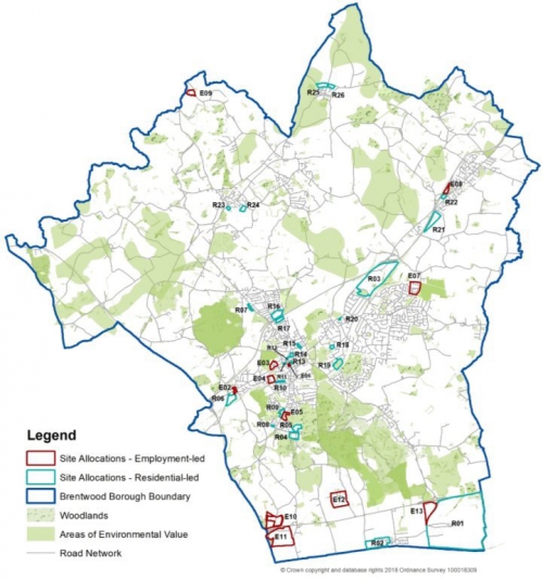
Overview Map
Residential-led Site Allocations
|
Site Policy Number |
Name |
|
R01 |
Dunton Hills Garden Village |
|
R02 |
West Horndon Industrial Estate |
|
R03 |
Land north of Shenfield |
|
R04 and R05 |
Ford Headquarters and Council Depot, Warley |
|
R06 |
Land off Nags Head Lane, Brentwood |
|
R07 |
Sow and Grow Nursery, Pilgrims Hatch |
|
R08 |
Land at Mascalls Lane, Warley |
|
R09 |
Land off Warley Hill, Warley |
|
R10 |
Brentwood railway station car park |
|
R11 |
Westbury Road Car Park, Brentwood |
|
R12 |
Land at Hunter House, Brentwood |
|
R13 |
Chatham Way car park, Brentwood |
|
R14 |
William Hunter Way car park, Brentwood |
|
R15 |
Wates Way Industrial Estate, Brentwood |
|
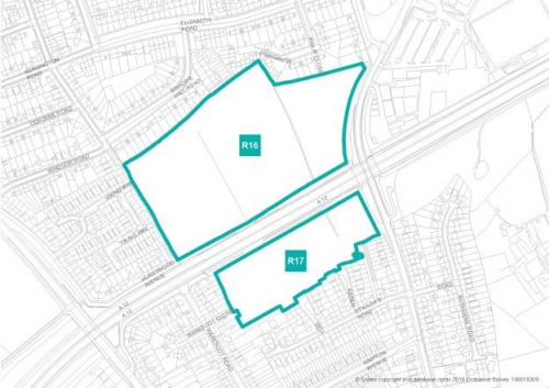
R16 and R17 |
Land off Doddinghurst Road, Pilgrims Hatch and Brentwood |
|
R18 |
Land off Crescent Drive, Shenfield |
|
R19 |
Land at Priests Lane, Shenfield |
|
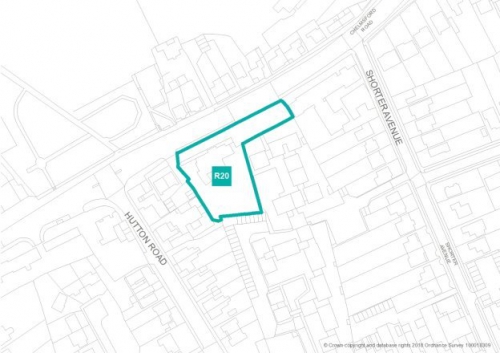
R20 |
The Eagle and Child Public House, Shenfield |
|
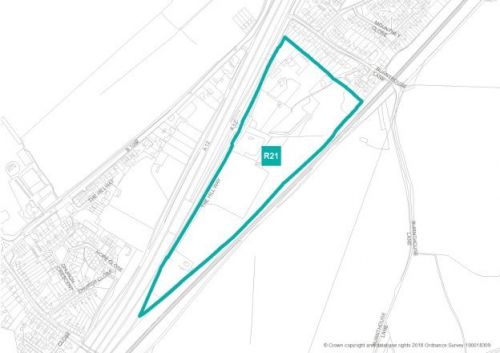
R21 |
Land south of Ingatestone |
|
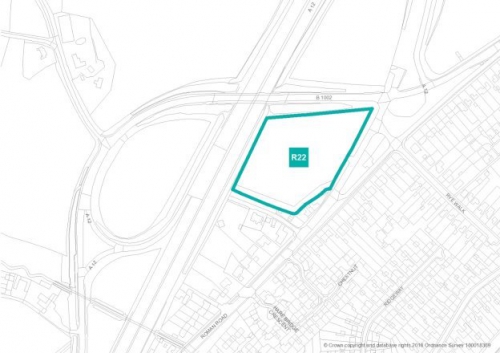
R22 |
Land adjacent to the A12, Ingatestone |
|
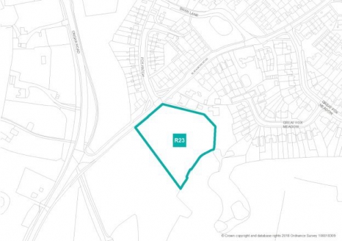
R23 |
Brizes Corner Field, Kelvedon Hatch |
|
R24 |
Land off Stocks Lane, Kelvedon Hatch |
|
R25 |
Land north of Woollard Way, Blackmore |
|
R26 |
Land north of Orchard Piece, Blackmore |
Employment Site Allocations
|
Site Policy Number[1] |
Name |
|
Existing Allocated Employment Land |
|
|
Part of E12 |
Childerditch Industrial Estate |
|
E09 |
Hallsford Bridge Industrial Estate |
|
E04 |
Hubert Road Industrial Estate, Brentwood |
|
E07 |
Hutton Industrial Estate, Wash Road, Hutton |
|
E01 & E02 |
Brook Street Employment Area |
|
E05 |
Warley Hill Business Park |
|
Part of R04 |
Ford Headquarters and Council Depot, Warley |
|
E03 |
BT Centre |
|
E06 |
OCE offices, Chatham Way, Brentwood |
|
Part of R02 |
West Horndon Industrial Estate |
|
Existing Employment Sites not previously allocated |
|
|
Part of E10 |
Land at Codham Hall |
|
Part of E12 |
Childerditch Industrial Estate |
|
New Employment Allocations |
|
|
E11 |
Brentwood Enterprise Park (M25 Works Site at A127/M25 junction 29) |
|
E08 |
Land adjacent to Ingatestone by-pass (part bounded by Roman Road) |
|
Part of E12 |
Childerditch Industrial Estate |
|
Part of E10 |
Land at Codham Hal |
|
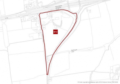
E13 |
Land at East Horndon Hall |
|
Part of R01 |
Dunton Hills Garden Village |
|
Part of R03 |
Land north of Shenfield |
(6) Residential Led Sites
------------------------------------------------------------------------------------------------------------------------------------
|
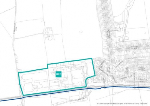
(1) R02 – Strategic Allocation – West Horndon Industrial Estate
|
|
|
Gross area: |
17.06ha |
|
Net developable area: |
10.23ha |
|
Indicative dwelling yield (net): |
580 |
|
Site access: |
Station Road and Childerditch Lane |
|
Delivery forecast: |
2021/22 – 2030/31 |
|
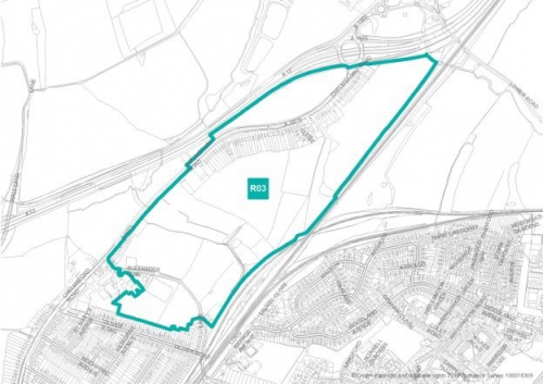
(1) R03 - Strategic Housing Allocation – Land north of Shenfield
|
|
|
Gross area: |
58.2ha |
|
Net developable area: |
28.2ha |
|
Indicative dwelling yield (net): |
825 |
|
Site access: |
Chelmsford Road (A1023) and Alexander Lane |
|
Delivery forecast: |
2023/24 – 2030/31 |
|
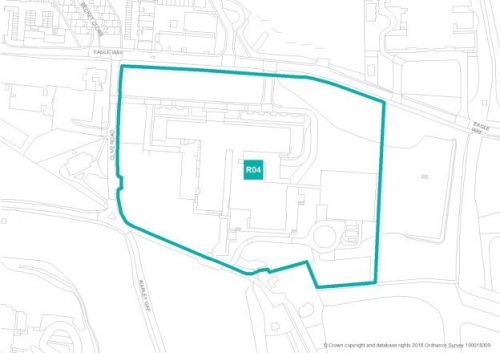
(1) R04 – Ford Headquarters and Council Depot, Warley - Southern Site
|
|
|
Gross area: |
5.34ha |
|
Net developable area: |
4.5ha |
|
Indicative dwelling yield (net): |
473 - across sites R04 and R05 |
|
Site access: |
Eagle Way |
|
Delivery forecast: |
2024/25 – 2032/33 |
|
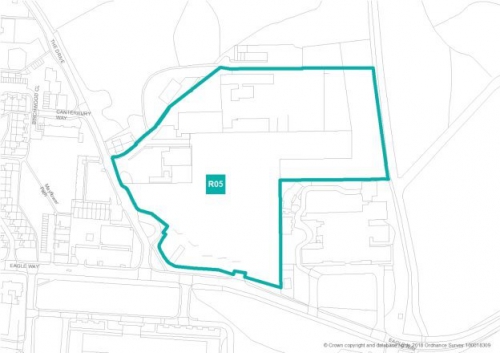
(1) R05 – Ford Headquarters and Council Depot, Warley - Northern Site
|
|
|
Gross area: |
4.06ha |
|
Net developable area: |
3.5ha |
|
Indicative dwelling yield (net): |
473 - across sites R04 and R05 |
|
Site Access: |
Eagle Way and The Drive |
|
Delivery Forecast: |
2024/25 – 2032/33 |
|
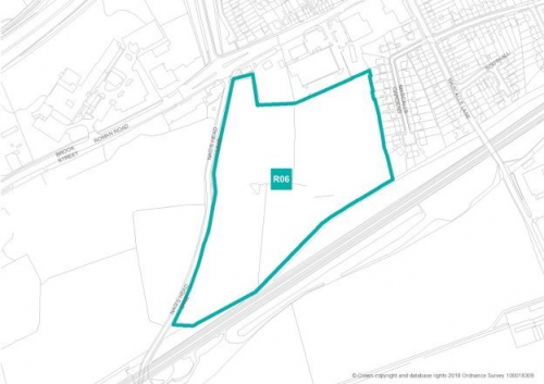
R06 – Land off Nags Head Lane, Brentwood
|
|
|
Gross area: |
5.88ha |
|
Net developable area: |
4.35ha |
|
Indicative dwelling yield (net): |
125 |
|
Site access: |
Nags Head Lane |
|
Delivery forecast: |
2021/22 – 2025/26 |
|
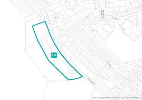
R07 – Sow and Grow Nursery, Pilgrims Hatch
|
|
|
Gross area: |
1.2ha |
|
Net developable area: |
1.08ha |
|
Indicative dwelling yield (net): |
38 |
|
Site access: |
Ongar Road |
|
Delivery forecast: |
2020/21 – 2021/22 |
|
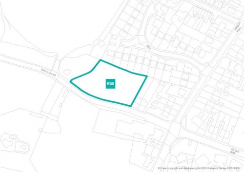
R08 – Land at Mascalls Lane, Warley
|
|
|
Gross area: |
0.34ha |
|
Net developable area: |
0.34ha |
|
Indicative dwelling yield (net): |
9 |
|
Site access: |
Mascalls Lane |
|
Delivery forecast: |
2020/21 |
|
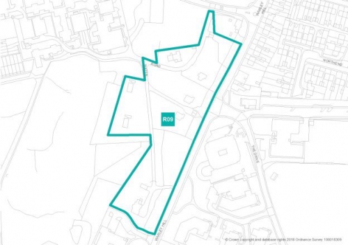
R09 – Land off Warley Hill, Warley
|
|
|
Gross area: |
2.21ha |
|
Net developable area: |
1.6ha |
|
Indicative dwelling yield (net): |
43 |
|
Site access: |
Pastoral Way |
|
Delivery forecast: |
2023/24 – 2024/25 |
|
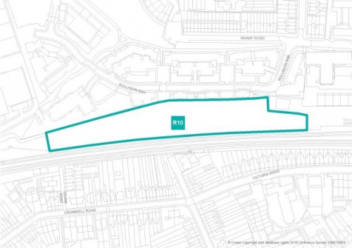
R10 – Brentwood railway station car park
|
|
|
Gross area: |
1.07ha |
|
Net developable area: |
0.96ha |
|
Indicative dwelling yield (net): |
100 |
|
Site access: |
St James Road |
|
Delivery forecast: |
2029/30 – 2032/33 |
|
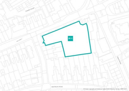
Gross area: |
0.27ha |
|
Net developable area: |
0.27ha |
|
Indicative dwelling yield (net): |
45 |
|
Site access: |
Westbury Road |
|
Delivery forecast: |
2020/21 – 2021/22 |
|
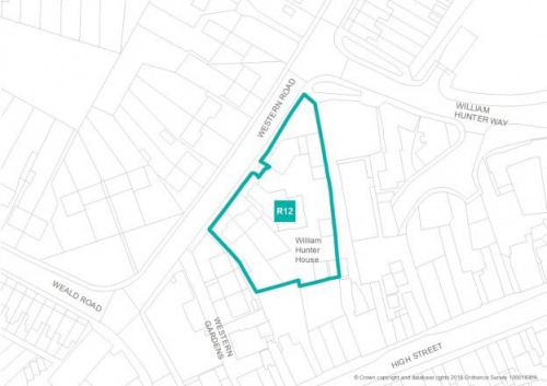
(1) R12 – Land at Hunter House, Brentwood
|
|
|
Gross area: |
0.21ha |
|
Net developable area: |
0.21ha |
|
Indicative dwelling yield (net): |
48 |
|
Site access: |
Western Road |
|
Delivery forecast: |
2024/25 – 2026/27 |
|
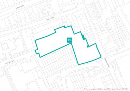
(1) R13 – Chatham Way car park, Brentwood
|
|
|
Gross area: |
0.33ha |
|
Net developable area: |
0.33ha |
|
Indicative dwelling yield (net): |
31 |
|
Site access: |
Chatham Way |
|
Delivery forecast: |
2020/21 – 2021/22 |
|
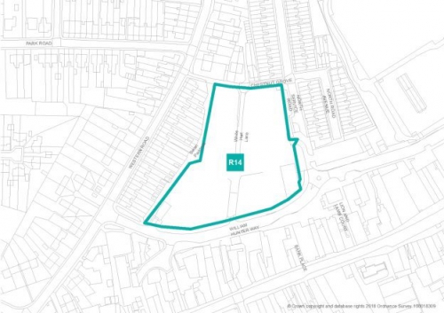
(2) R14 – William Hunter Way car park, Brentwood
|
|
|
Gross area: |
1.3ha |
|
Net developable area: |
1.22ha |
|
Indicative dwelling yield (net): |
300 |
|
Site access: |
William Hunter Way |
|
Delivery forecast: |
2022/23 – 2028/29 |
|
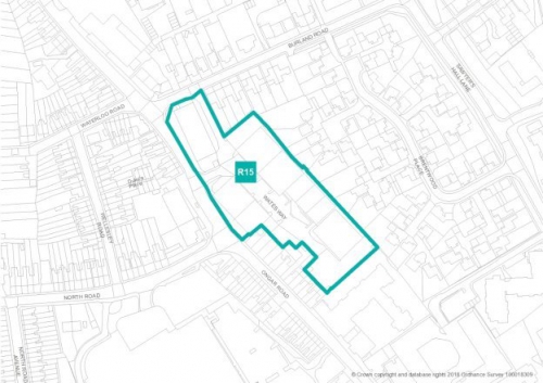
R15 – Wates Way Industrial Estate, Brentwood
|
|
|
Gross area: |
0.99ha |
|
Net developable area: |
0.89ha |
|
Indicative dwelling yield (net): |
80 |
|
Site access: |
Ongar Road (A128) |
|
Delivery forecast: |
2022/23 – 2025/26 |
|
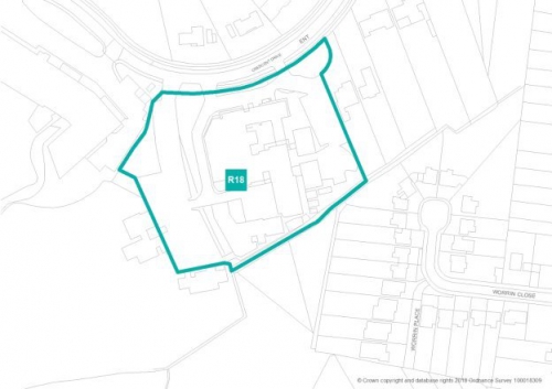
R18 – Land at Crescent Drive, Shenfield
|
|
|
Gross area: |
1.54ha |
|
Net developable area: |
1.39ha |
|
Indicative dwelling yield (net): |
55 |
|
Site access: |
Crescent Drive |
|
Delivery forecast: |
2021/22 – 2023/24 |
|
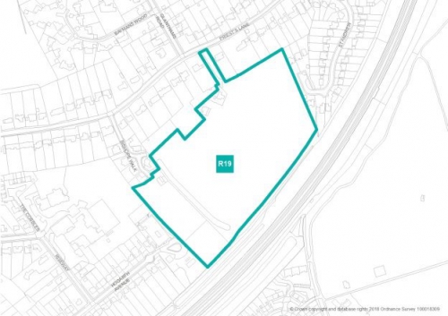
R19 – Land at Priests Lane, Shenfield
|
|
|
Gross area: |
5.4ha |
|
Net developable area: |
3.84ha |
|
Indicative dwelling yield (net): |
75 |
|
Site access: |
Priests Lane |
|
Delivery forecast: |
2020/21 – 2022/23 |
|
(2) R21 – Land south of Ingatestone
|
|
|
Gross area: |
6.04ha |
|
Net developable area: |
4.74ha |
|
Indicative dwelling yield (net): |
161 |
|
Site access: |
Roman Road |
|
Delivery forecast: |
2021/22 – 2023/24 |
|
R22 – Land adjacent to the A12 by-pass, Ingatestone
|
|
|
Gross area: |
1.39ha |
|
Net developable area: |
1.25ha |
|
Indicative dwelling yield (net): |
57 |
|
Site access: |
Roman Road |
|
Delivery forecast: |
2021/22 – 2023/24 |
|
R23 – Brizes Corner Field, Kelvedon Hatch
|
|
|
Gross area: |
0.87ha |
|
Net developable area: |
0.78ha |
|
Indicative dwelling yield (net): |
23 |
|
Site access: |
Blackmore Road |
|
Delivery forecast: |
2021/22 – 2022/23 |
|
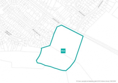
R24 – Land off Stocks Lane, Kelvedon Hatch
|
|
|
Gross area: |
2.15ha |
|
Net developable area: |
1.61ha |
|
Indicative dwelling yield (net): |
30 |
|
Site access: |
Stocks Lane |
|
Delivery forecast: |
2021/22 – 2022/23 |
|
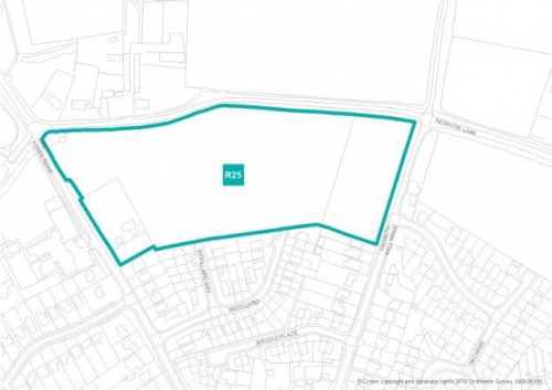
(2) R25 – Land north of Woollard Way, Blackmore
|
|
|
Gross area: |
3.3ha |
|
Net developable area: |
2.48ha |
|
Indicative dwelling yield (net): |
40 |
|
Site access: |
Redrose Lane |
|
Delivery forecast: |
2023/24 – 2024/25 |
|
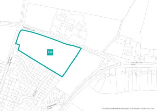
(1) R26 – Land north of Orchard Piece, Blackmore
|
|
|
Gross area: |
1.69ha |
|
Net developable area: |
1.52ha |
|
Indicative dwelling yield (net): |
30 |
|
Site access: |
Redrose Lane |
|
Delivery forecast: |
2021/22 – 2022/23 |
(1) Employment Sites
------------------------------------------------------------------------------------------------------------------------------------
|
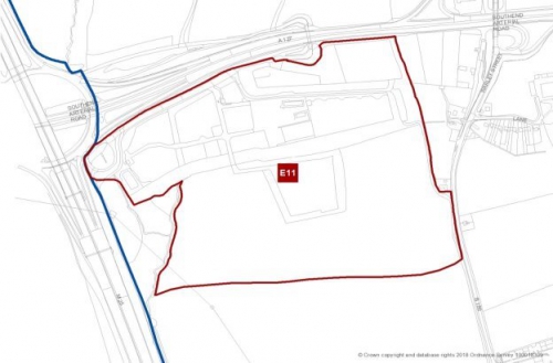
(1) E11 – Brentwood Enterprise Park
|
|
|
Gross area: |
35.5ha |
|
Developable area: |
25.85 ha |
|
Site access: |
M25 Junction 29 and/or Warley Street (B186) |
|
Delivery forecast: |
Years 5-15 |
|
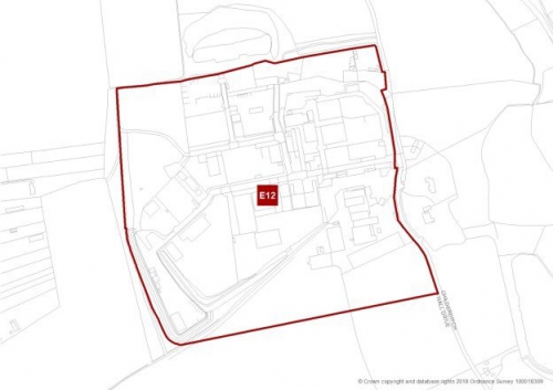
E12 – Childerditch Industrial Estate
|
|
|
Gross area: |
20.64 ha |
|
Developable area: |
20.64 ha |
|
Site access: |
A127 |
|
Delivery forecast: |
Years 1-10 |
|
|
|
|
Gross area: |
17.6ha (comprising 9.6ha employment and 8.0ha landscaping) |
|
Net additional area: |
0.61ha (currently undeveloped land) |
|
Site access: |
M25 Junction 29 |
|
Delivery forecast: |
Years 1-5 |
|
(1) E13 – East Horndon Hall
|
|
|
Gross area: |
12.9ha |
|
Developable area: |
5.5ha |
|
Site access: |
Old Tilbury Road |
|
Delivery forecast: |
Years 1-5 |
|
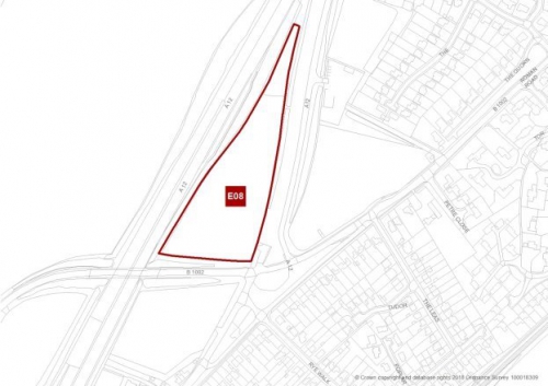
(2) E08 – Land Adjacent to A12 and Slip Road, Ingatestone
|
|
|
Gross area: |
2.06ha |
|
Developable area: |
1.6ha |
|
Site access: |
Roman Road (B1002) |
|
Delivery forecast: |
Years 1-5 |