Brentwood Local Plan 2016 - 2033 (Pre-Submission, Regulation 19)
2. Borough of Villages
(2) Introduction to Borough Profile
2.1 The following paragraphs set out the context of the Borough and the key issues that should be addressed when planning for its future. Illustrative infographics summarising some of the key issues are provided at the end of the chapter in Figure 2.6 (parts 1 & 2).
2.2 The supporting document 'Brentwood Borough Profile' further details the borough context, providing a baseline study of key borough characteristics, which can be viewed online at www.brentwood.gov.uk/localplan.
Location
(1) 2.3 Located in the south-west of the county of Essex and east of Greater London, Brentwood Borough is set within the Essex Countryside. The borough has easy access to the countryside as well as to London, along established road and rail networks. Our location offers the best of both worlds, making Brentwood an attractive place to live, work and visit.
2.4 Being set within London's Metropolitan Green Belt poses some development constraints. However, it also sets a foundation for a creative and innovative response to sustainable development where the principles of 'designing and building with nature' can be embedded to create and enhance neighbourhoods that deliver health and well-being for all.
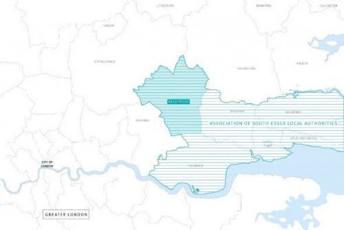
Figure 2.1: Brentwood Borough Location
Origin
2.5 Brentwood's hamlet origins can be traced back to the 11th Century, with its name (Burnt Wood) signifying the clearings made by fire of the Great Forest of Essex. Administratively, Brentwood evolved as a Parish, later as the Brentwood Urban District. Brentwood's development was due mainly to its position on the higher grounds in the parish, at the junction of the main London to Colchester road and the Ongar-Tilbury Road.
2.6 St. Osyth's abbey, Lord of the manor of Costed was licensed to hold the first market and fair here in 1227. The market grew in prominence due to its convenient location, and Brentwood as a 'market town' started to evolve. The urban district was eventually abolished by the Local Government Act 1972, as the district grew to encompass the nearby parishes of Ingatestone, Mountnessing, Doddinghurst and others. It gained borough status in March 1993, characterised by the suburban core of Brentwood and Shenfield surrounded by a series of villages, thereby giving rise to its dominant character as a 'Borough of Villages'
2.7 From its hamlet to market town origins, Brentwood is today considered an attractive residential borough with a short commute to London or Chelmsford and is also home to a number of notable industries.
(7) Settlement Hierarchy
(1) 2.8 To promote sustainable growth in rural areas, the NPPF (2018) paragraph 78 states that housing in rural areas should be located where it will enhance the vitality of rural communities, to ensure villages grow and thrive. To ensure the Local Plan responds to this, a broad Settlement Hierarchy Assessment has been undertaken to understand the role, function and relationship of Brentwood's dispersed settlements (Figures 2.2 & 2.3).
Figure 2.2: Brentwood Borough Settlements
2.9 Figure 2.3 sets out the Borough's Settlement Hierarchy categories, to identify their role (constraints and opportunities) for delivering sustainable growth and how their heritage character might inform future change.
2.10 The settlement hierarchy should not be confused with the Retail Town Centre Hierarchy categories detailed in Chapter 7.
|
Type of Settlement |
Settlement Name |
Population[2] |
|
Settlement Category 1 Large towns and urban neighbourhoods in compact urban settings that collectively form the Brentwood Urban Area. They provide a wide range of services and opportunities for employment, retail, education, health and leisure facilities to the immediate residential areas as well as to the wider population in the borough. They are typically highly accessible and well served by public transport provision, including rail services, and existing infrastructure. Development opportunities should focus on making the best use of land, with higher density and brownfield redevelopment being prioritised, consistent with local character. Infrastructure capacity should inform the appropriate level of development and development contribution. |
||
|
Large town |
Brentwood |
22,410 |
|
Large town |
Shenfield |
20,790 |
|
Urban neighbourhood |
Hutton |
1,405 |
|
Urban neighbourhood |
Pilgrims Hatch |
5,632 |
|
Urban neighbourhood |
Warley |
2,213 |
|
Urban neighbourhood |
Brook Street |
1,093 |
|
Settlement Category 2 Larger villages in a rural setting, with high levels of accessibility and public transport provision, including rail services. They provide a range of services and facilities to the immediate residential areas and nearby settlements. Appropriate urban extension and brownfield redevelopment opportunities will be encouraged to meet local needs. The level of development in these settlements should consider their infrastructure constraints and setting. |
||
|
Large village |
Ingatestone (including Heybridge) |
4,812 |
|
Large village |
West Horndon |
1,537 |
|
Garden village |
Dunton Hills |
n/a[3] |
|
Settlement Category 3 Villages in a sparse rural setting that provide day to day needs for local residents. Brownfield redevelopment opportunities and limited urban extensions will be encouraged to meet local needs where appropriate. Development should be appropriate to the rural setting of the area. |
||
|
Rural village |
Blackmore |
829 |
|
Rural village |
Doddinghurst |
2,550 |
|
Rural village |
Herongate |
648 |
|
Rural village |
Ingrave |
1,198 |
|
Rural village |
Kelvedon Hatch |
2,124 |
|
Rural village |
Mountnessing |
494 |
|
Settlement Category 4 Remote and small rural villages and hamlets, with poor public transport, limited shops, jobs and community facilities; some of these settlements rely on nearby settlements for services. Development opportunities are limited, although as with larger villages brownfield redevelopment opportunities will be encouraged to meet local needs where appropriate. |
||
|
Rural village in a sparse setting |
Wyatt's Green |
936 |
|
Rural village in a sparse setting |
Hook End |
637 |
|
Rural village in a sparse setting |
Stondon Massey |
359 |
|
Rural village in a sparse setting |
Fryerning |
255 |
|
Rural village in a sparse setting |
Great Warley |
309 |
|
Rural village in a sparse setting |
Little Warley |
data not available |
|
Rural village in a sparse setting |
South Weald |
233 |
|
Other hamlets in the Borough, which are more isolated and dispersed with limited connectivity and services. They mainly rely on nearby settlements for services and therefore not suitable for new development. |
||
(13) Figure 2.3: Settlement Hierarchy
Settlement Category 1
2.11 Brentwood Urban Area, made up of semi-connected settlements such as Brentwood, Shenfield, Hutton, Warley, Brook Street, and Pilgrims Hatch, is the borough's largest settlement. Accessible and well served by public transport, with rail stations at Brentwood and Shenfield, Brentwood Urban Area provides a range of shopping, employment areas, secondary schools, health and leisure facilities in close proximity to residential areas.
2.12 Within this settlement category, Brentwood and Shenfield offer the most scope to develop in accordance with sustainable development principles. Urban extensions into Green Belt are proposed in specific locations with clear physical defensible boundaries and accessible to local services and transport links. Release of land for development in these locations will in time enable a five-year supply of housing to be achieved, boosting local housing needs swiftly in line with national policy and guidance.
Settlement Category 2
(1) 2.13 Ingatestone is the borough's largest village; facilities here serve a significant catchment beyond the immediate area. Public transport accessibility is relatively good. The village has a rail station and secondary school. While Ingatestone has relatively good facilities, a modest level of development is envisaged here, due to infrastructure constraints and a lack of suitable sites.
(1) 2.14 Future development as guided by the Plan will result in changes to the hierarchy, adding West Horndon and Dunton Hills Garden Village to this category. Brownfield residential development at West Horndon is proposed to be of a size to provide for a new village centre along with new retail and job opportunities, and to assist with improvements at West Horndon railway station. Development at Dunton Hills Garden Village will create a new self-sustaining village with provision of new schools alongside retail, job opportunities and health facilities. Policies for the delivery of Dunton Hills Garden Village will set the precedent for new accessible connections to be made with West Horndon railway station nearby, providing a new transport interchange, among other aspirations.
Settlement Category 3
2.15 Larger villages in the borough are served by a local shopping parade and a primary school. They generally have limited, often shared, community and health facilities, local jobs and a variable bus service.
2.16 Brownfield redevelopment opportunities will be encouraged to meet local needs and policies in this Plan will help to bring forward nearby redevelopment of brownfield sites in the Green Belt where appropriate. Minimal amendments are proposed to the Green Belt boundaries surrounding larger villages in order to retain the character of the borough in line with the spatial strategy.
Settlement Category 4
2.17 Remote smaller villages and hamlets, some within the Green Belt. These settlements have limited local services and facilities and poor public transport links, reliant on other settlements nearby in many cases. Development in these locations will be encouraged only in brownfield locations, steered by the policies in the Plan.
Our Story
(3) Transport and Travel
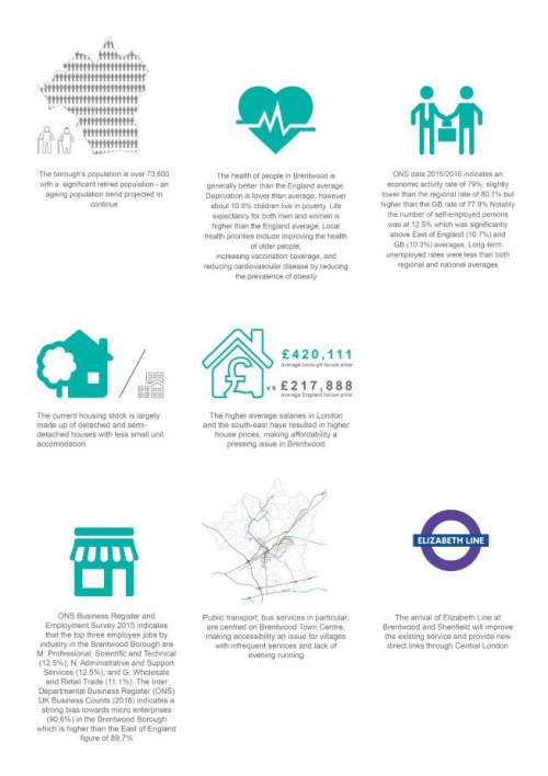
2.18 Brentwood Borough is well connected to road and rail networks. Major roads such as the M25, A12 and A127 run through the borough and the M11 and Stansted Airport are within easy reach. Despite good accessibility and location, traffic congestion is one of the main issues affecting quality of life (air quality) and local economic performance.
2.19 Brentwood has a very high level of car ownership compared to the national average. Without alternative means of transport the use of cars will continue to dominate as a mobility mode to access nearby services, employment and leisure facilities. Therefore, the delivery and encouragement of sustainable transport alternatives is essential.
2.20 There are four rail stations in the borough: Brentwood, Shenfield, Ingatestone, and West Horndon. Brentwood station is located on the Great Eastern Mainline, served by both TfL rail services to London Liverpool Street and Abellio Greater Anglia services to Southend Victoria and London. Shenfield is a major interchange for the Great Eastern Main to London Liverpool Street and East Anglia. Ingatestone station is also on the Great Eastern Mainline, with a slightly less frequent service. West Horndon station is on the London-Tilbury-Southend Line to London Fenchurch Street. The Elizabeth Line will soon serve Brentwood and Shenfield stations; it will provide the borough with an improved train service, including increased capacity, station improvements and new direct links through central London, to Heathrow Airport and Reading.
2.21 Bus services generally start and terminate in Brentwood Town Centre with links to other parts of the borough and other places outside the borough. However, bus services in more rural areas are limited, particularly at off-peak times.
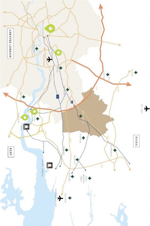
2.22 The percentage of those who cycle to work is below the national average, but more people walk to work than average. Some cycle routes flow through the borough, but these can sometimes be disconnected. Encouraging sustainable travel patterns is of key importance.
Population and Housing
2.23 The population in 2011 was 73,601 (Census), of which approximately 70% live in the Brentwood urban area. The 2014 mid-year population estimate shows that this has increased to 75,600.
2.24 The proportion of the population from minority ethnic groups in the borough is well below average for the Eastern of England, and England as a whole. The largest non-white minority ethnic group is made up of people of Asian origin.
2.25 Brentwood is one of the most affluent areas in England, within the least deprived 10% of the country.
2.26 There are just over 32,000 homes in Brentwood Borough. The main property type is detached and semi-detached houses, which makes up almost 63% total stock compared to the national average of 53%. The main property size is 3-bedrooms (35%), followed by 2-bedrooms (25%) and 4-bedroom homes (23%).
2.27 House prices in the borough are very high in comparison with the rest of Essex. This can cause issues preventing people from buying homes with entry level housing often too expensive for many newly forming households and the need for a significant deposit.
Economy and Employment
2.28 Brentwood Borough has a successful and buoyant local economy, providing for over 30,000 jobs. Banking and finance are the main business sector followed by distribution/ hotels/ restaurants and public services. The local business structure is dominated by micro (1-10 employees) and small businesses (11-49 employees), while entrepreneurial activity is high.
2.29 Office employment areas are mainly located within the Brentwood Town Centre, Brentwood station area and Warley Business Park. Major employers include BT, Canon, Countryside Properties, Ford and LV Insurance.
2.30 Despite the borough's rural character employment in agriculture is below the national average. Manufacturing sector is also under represented.
2.31 Three quarters of the borough population is of working age (16-65). This proportion has fallen over time as the population ages. There continues to be a rise in the number of people of working age in the borough, but a disproportionate rise in the number of older people.
2.32 Average weekly wages for those who live here but work elsewhere are higher than for those who work in the borough. A high proportion of people are employed as managers, senior officials, and in associated professional and technical occupations, reflecting the number of people commuting to places like central London.
Retail and Shopping
2.33 Brentwood Borough offers a wide range of retail and commercial leisure facilities. The main shopping area, Brentwood Town Centre, is centred on the High Street. The Town Centre provides a range of retail, restaurants and cafes, including a quality independent niche shopping offer.
2.34 District Shopping Centres at Shenfield Hutton Road, Ingatestone High Street, Warley Hill (Brentwood Station), and many smaller local parades and individual shops serve residential areas and villages. Each centre plays an important role providing a range of essential local services.
Sport and Leisure
(1) 2.35 The borough benefits from extensive open areas for informal recreation. South Weald and Thorndon Country Parks provide 324 hectares of open space along with numerous publicly accessible playing fields, parks, woodlands and amenity greens.
2.36 Brentwood Leisure Centre and Shenfield Sports Centre, along with privately run sports and leisure facilities, are the focus for indoor sport and recreation. In addition, excellent sporting facilities are provided at several schools and can be accessed for public use.
Heritage, Natural and Built Environment
(1) 2.37 The borough has significant built and natural heritage. It has over 500 listed buildings, 13 Conservation Areas, 12 scheduled ancient monuments, 100s of sites of archaeological interest, accessible countryside and parks, varied landscapes and numerous Local Wildlife Sites. Together, these features provide an attractive, sought after location for residents, businesses and visitors.
2.38 Development, whether existing or new, invariably places demands on the environment. Among these are unsustainable use of resources (materials, water, energy), waste disposal issues, pollution (of air, water or soil) and loss of or harm to wildlife habitats, historic buildings and landscapes.
2.39 The borough, in common with other places, depends on fossil fuel energy for homes, business and transport, and other finite resources, such as water and land. Fossil fuel energy gives rise to greenhouse gas emissions and climate change and in future may not be readily available in the way it has been in the past. We therefore need alternatives, including renewable energy and local supplies.
2.40 Agricultural land grades describe the non-urban areas of the borough as Good to Moderate with a few areas as Very Good within the northern areas of the borough[4].
2.41 This Plan places a high priority on the prudent use and good management of resources and effective protection for the environment. Both the form and location of future development and how buildings and land are used are fundamental to safeguarding those qualities which make Brentwood special and ensure these continue to be available for future generations to enjoy.
Arts and Community
2.42 Brentwood Borough has a strong and dedicated arts community. There are over 70 arts organisations and societies delivering arts events throughout the year. Participation numbers in the borough are high with many people regularly taking part in an arts activity in their leisure time.
2.43 Local facilities, such as parish, village and neighbourhood halls provide for a range of community and cultural activities, such as play groups, clubs, social activities and public meeting space.
2.44 There are nine Parish Councils covering much of the borough's rural areas. However, the majority of the population live in unparished areas, such as the Brentwood Urban Area.
(3) Health and Well-being
2.45 Health is defined as a state of complete physical, mental and social well-being and not merely the absence of disease or infirmity. The Council is working with partners to achieve a healthier Brentwood, so that people can enjoy good health and a sound and vigorous mentality.
2.46 The health of Brentwood Borough residents is generally better than the England average according to Public Heath England. Life expectancy is above average. Levels of obesity, diabetes and drug misuse are below the national average.
(1) 2.47 Brentwood residents have to travel outside the borough to access main hospital facilities including accident and emergency. However, the borough benefits from a small NHS community hospital in Brentwood and other private medical facilities. GP surgeries are generally at capacity. NHS England has identified an additional need for GPs subject to the location of future development.
2.48 Basildon & Brentwood Clinical Commissioning Group (CCG) are responsible for planning, designing, buying and performance managing NHS services in the area. This includes a wide range of services such as most planned hospital care, rehabilitation care, urgent and community care, community health services and mental health and learning disability services.
(3) Education and Schools
2.49 Borough residents have higher than average levels of educational attainment when compared to both the rest of England and East of England. The borough has higher than average levels of school pupils achieving five good GCSEs and proportion of population with degree level education or equivalent. There is a lower than average proportion of population with no qualifications.
2.50 The borough has many well performing schools and colleges. Essex County Council is the local education authority although many schools are now self-governing, managing their own budgets and employing their own staff. There are also several independent or private schools in the borough. As academy schools are being encouraged, it will be important to work with partners to ensure adequate education provision is available to existing and future local residents.
2.51 Primary schools in the borough are generally at capacity, particularly within the Brentwood Urban Area, and some have limited physical space to expand. Secondary schools are generally performing with spare capacity.
Utilities, Telecoms and Media
2.52 Power, gas and water networks will need to be considered when planning the borough's future. The Council is working with energy and water providers as part of the plan-making process. In addition, new development will require connections to telecoms and broadband networks.
2.53 Broadband internet connection and superfast speeds have become an essential everyday utility for homes and businesses across the country. Coverage in Brentwood varies between urban and rural areas. Essex County Council has committed to a significant broadband infrastructure upgrade with telecoms partners. Broadband speed is an important issue for the UK economy and international competition.
Green Belt
(2) 2.54 All of the borough's countryside lies within Metropolitan Green Belt of London. That equates to 89% of the borough, the sixth highest in England by percentage of total area. This helps protect much of the high-quality agricultural land and countryside. However, it also constrains development opportunities, making it difficult to meet development needs in full.
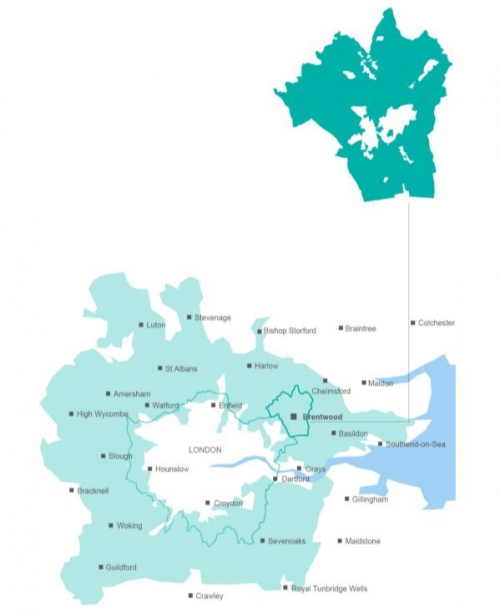
Figure 2.5: Metropolitan Green Belt (Part 1 of 2)
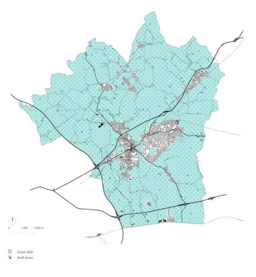
Figure 2.5: Metropolitan Green Belt (Part 2 of 2)
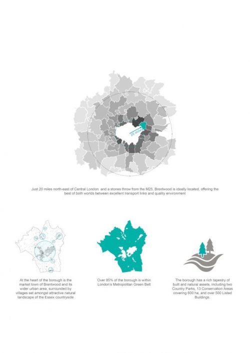
Figure 2.6: Our Story (Part 1 of 2)