Draft Local Plan
10. Quality of Life and Community Infrastructure
Covering a wide range of issues around infrastructure, community facilities, sport & leisure, flood risk & drainage, telecommunications and utilities.
SO11 - Protect and nurture existing leisure, cultural and recreational assets such as the Borough's Country Parks for residents and visitors to the Borough and promote and enhance social inclusion, health and wellbeing
SO12 - Improve public transport, cycling and walking facilities and encourage sustainable transport choices
S013 - Secure the delivery of essential infrastructure, including transportation schemes and community facilities in order to support new development growth throughout its delivery
10.1 This chapter covers a range of issues due to the amount of things that need to be considered when planning for new infrastructure to link communities with various services. The Council is committed to ensuring the quality of life for those who live and work in the Borough is always improving. This needs to be balanced with demand for new people moving into new homes and jobs.
10.2 Both existing and new infrastructure will need to be considered as part of planning for the Borough's future over the next 15 years. Infrastructure broadly means the basic structure and facilities needed for society. In local terms, this is termed to mean the essential services and facilities for communities, such as roads and rail, transport, schools, healthcare, community facilities, and utilities. Utilities can also mean a range of services, such as power, water, drainage, and telecoms (including broadband). All these key services are essential to ensuring a good quality of life.
(7) Sustainable Transport
10.3 Sustainable transport is a key component of sustainable development. Sustainable transport refers to any means of transport which reduces the impact on the environment, and includes nonmotorised transport, ie walking and cycling, public transport, low emission vehicles, vehicle charging points and car sharing.
10.4 Many aspects of transport and travel need to be considered, including encouraging walking and cycling to reduce dependency on car travel and improvements to public transport. The arrival of Crossrail will provide an improved and more frequent service to those who live and work in the Borough as well as a better link to London and beyond for those visiting. Other public transport services will need to follow suit if the wider development needs of south east England are to be sustainably provided.
10.5 It is also important that we consider car ownership and be realistic about the fact that most homes in the Borough will own a car. While public transport links into London are good for Brentwood town and other areas in transport corridors, villages are more remote with less good access. Therefore, acceptance of car travel and parking considerations will be important for Brentwood as we consider the future.
(38) POLICY 10.1: SUSTAINABLE TRANSPORT
The Council will work with partners to facilitate and promote sustainable transport. This includes improving accessibility, creating opportunities for 'active travel' and reducing congestion and pollution.
Future developments will be located in accessible locations to help reduce the need to Travel. Where travel is necessary public transport (rail, bus, taxi), walking, and cycling will be promoted as an alternative means of transport to the private car. Major generators of travel demand should be located in Brentwood Town Centre and in District Centres. Applications for large scale development proposals will need to be accompanied by a Transport Assessment. For smaller scale developments a Transport Statement will be required. Advice should be sought from the Highway Authority on the requirements of any Transport Assessment or Statement.
Sustainable transport links will be extended and improved. Developer contributions will be sought to improve links from new development to key destinations and the wider network. This will include new or improved infrastructure, services and promotion to support walking, cycling and public transport, including Quality Bus Partnerships. Sustainable travel will be encouraged through the requirement for residential travel plans and packs for major developments, employers and institutions, including provision of charging points for electric vehicles.
The Council, in consultation with partners, will seek the retention of existing bus and rail services and, where possible, encourage improved and new services. Support will be given to the refurbishment of rail station buildings and other improvements in facilities for public transport users including transport interchange improvements. The Council will seek additional taxi facilities for the Borough, where appropriate.
Traffic and car parking will be carefully managed to encourage sustainable travel.
Cycling will be promoted through the provision of improved cycle parking and other facilities and new cycle routes as part of highway infrastructure improvements/traffic management measures and, where appropriate, in association with planning permission for new development.
Development close to schools and Early Years & Childcare facilities should facilitate an attractive public realm that is safe for children and encourages walking and cycling as opposed to school run traffic.
Green Travel Route
In order to provide better Borough links for strategic
development allocations outside Brentwood urban area, a
Travel Plan will be required. A Green Travel Route linking
Brentwood Town Centre with strategic allocations in the
A127 Corridor will provide improved links and public
transport choices.
Crossrail
The Council support the development of Crossrail,
maximising the potential for an overall improvement to
Borough rail services, and mitigating any environmental or
transport impacts as a consequence of the proposals through
improving and encouraging sustainable transport. The
Council will work with other stakeholders to secure funding
for improvements to the public realm and circulation around
both Brentwood and Shenfield Crossrail stations given the
potential increased usage and footfall expected to arise
from Crossrail. The Council will consider the scope for
'park and walk' schemes where the demand and impacts are
assessed within a detailed feasibility study.
10.6 Policy 10.1 aims to ensure that new development reduces the need to travel, gives priority to pedestrians and cyclists and convenient access to jobs, homes, shops, public transport and services, such as education, healthcare, recreational facilities and open space.
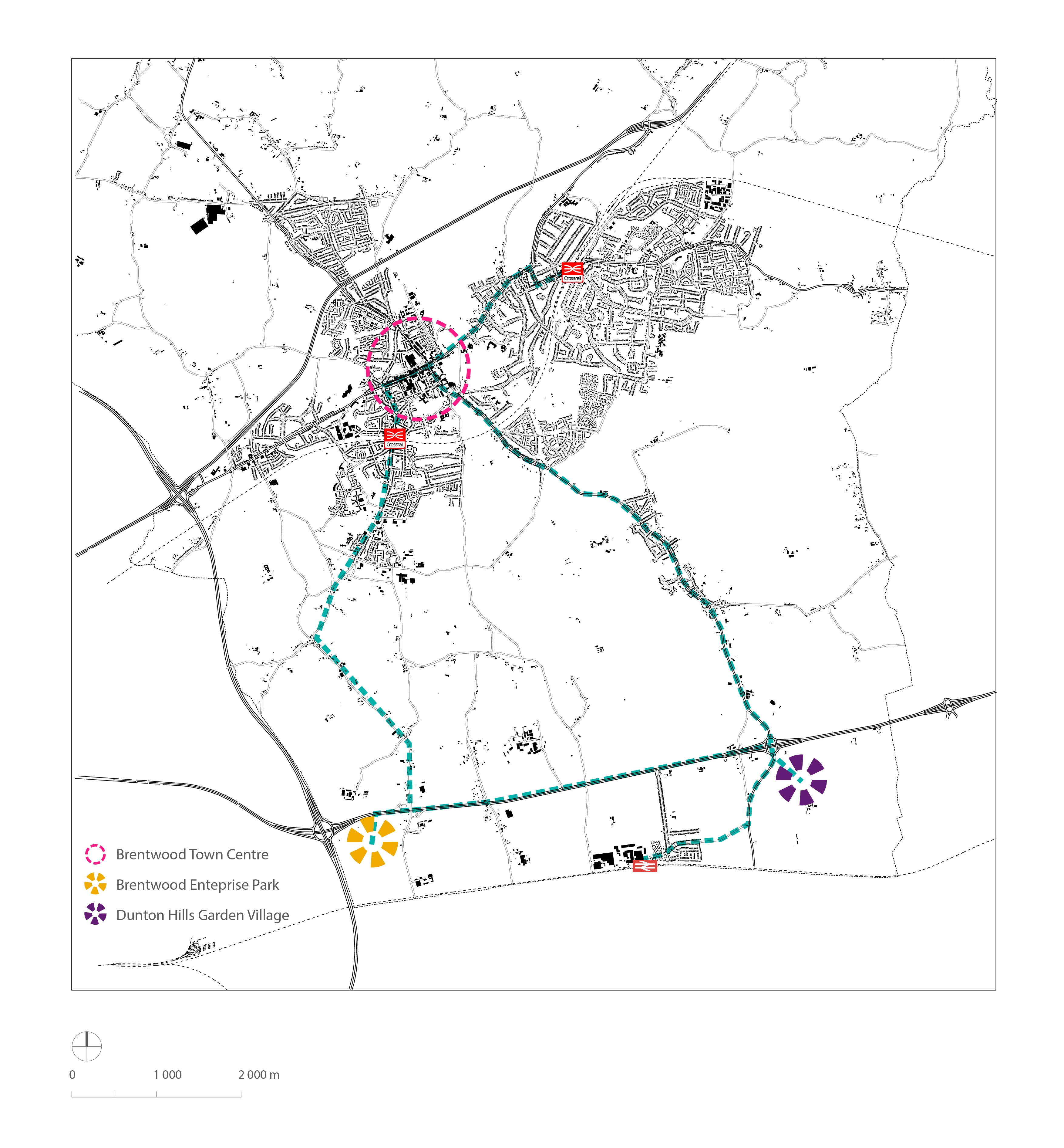
(2) FIGURE 10.1: GREEN TRAVEL ROUTE
10.7 While the aim will be to offer a choice of transport, reducing dependency on the car will improve resilience in the face of future fuel shortages or price rises. Securing public transport improvements and better provision for walking and cycling will reduce pollution, make it safer and easier for people to travel to jobs and services and lead to better health, less congestion and more pleasant streets. The Government's Active Travel Strategy (Dept of Health and Dept for Transport, 2010) aims to get more people walking and cycling in recognition of the many benefits these bring. As the Strategy notes, walking or cycling can be quicker and cheaper than driving or taking public transport for many short trips and are an easy way to become more physically active thereby improving health and wellbeing.
10.8 To better link strategic allocations in the A127 Corridor, it is proposed that a Green Travel Route will link these areas to Brentwood Town Centre. This will provide improved links and public transport to Brentwood Town Centre and Crossrail station. Discussions with Essex County Council are ongoing regarding more detail in terms of bus services and supporting infrastructure; projected demand for any service; potential costs and deliverability, partners, funding and sustainability over the long term.
10.9 The arrival of Crossrail will provide benefits to local residents and businesses in terms of improved service and connections. The Council will encourage improvements to the public realm surrounding Brentwood and Shenfield stations, and look to improve access and parking provision. The Council will consider Park and Ride or Park and Walk schemes to improve access to the stations, a detailed feasibility study will be required.
10.10 Aims to reduce pollution levels from transport can also be linked to Policies 10.10 Green Infrastructure and 10.11 Air Quality.
(7) POLICY 10.2: PARKING
The Council will refer developers to the latest Vehicle Parking Standards adopted by Brentwood Borough Council. Schemes should comply with design standards and provision levels for uses and transport modes specified. The level of parking provision required will depend on the location, type and intensity of use.
10.11 Vehicle parking standards aim to ensure an appropriate level and location of car parking provision that also contributes to the public realm. It is important that appropriate parking standards are applied at all developments.
10.12 Brentwood Borough Council adopted vehicle parking standards as a Supplementary Planning Document (SPD) in March 2011 and will expect these standards to apply until such time as they are revoked or superseded by other standards. This document sets out a range of standards to be applied depending on the proposed use of new development.
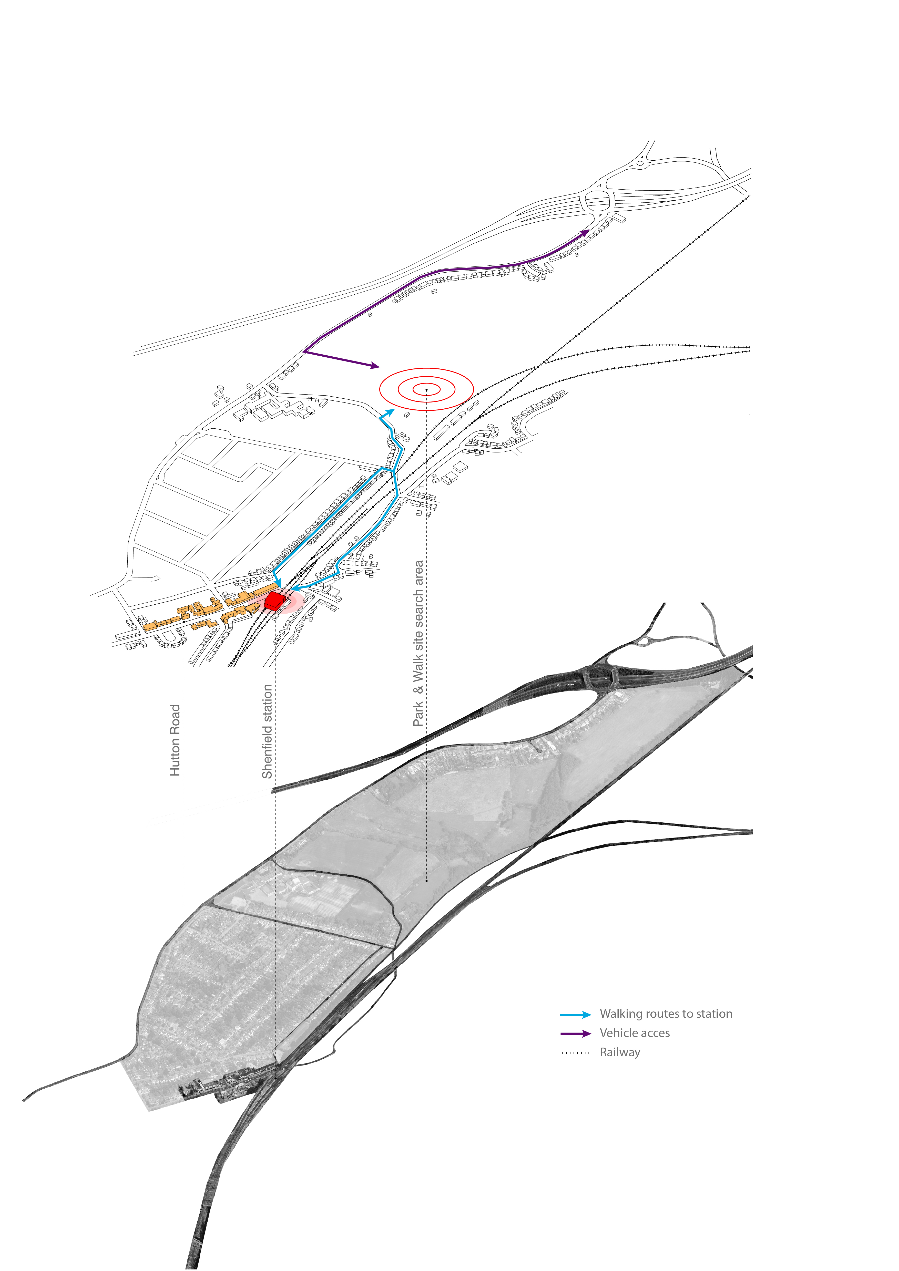
(1) FIGURE 10.2 CROSSRAIL PARK & WALK OPTION
Sustainable Construction and Energy
10.13 As we look to plan for the future of the Borough it will be essential to consider how we more efficiently use resources.
10.14 There is increasing recognition that reducing carbon is important in reducing and adapting to the impacts of climate change, reducing dependence on private cars and locating new development in sustainable, accessible, locations, increasing energy efficiency, or by increasing the use of renewable or low carbon energy sources.
10.15 It is important to ensure that we adapt to the inevitable changes to future climate. This applies to the built development, its location, design, layout and proposed land uses.
(5) POLICY 10.3: SUSTAINABLE CONSTRUCTION AND ENERGY
The Council will require all development proposals, including the conversion or re-use of existing buildings, to:
- a. maximise the principles of energy conservation and efficiency in the design, massing, siting, orientation, layout and use of materials;
- incorporate water conservation measures;
- incorporate suitable Sustainable Urban Drainage Systems (SuDs), such as green roofs and rainwater attenuation measures;
- submit a Water Sustainability Assessment;
- submit details of measures that increase resilience to the threat of climate change, including but not limited to summertime overheating; and
- incorporate the reduction in the use of mineral resources, including an increase in the re-use of aggregate.
The Council will expect:
- the provision of commercial and domestic scale renewable energy and decentralised energy as part of new development, new build or conversions of 500sqm or more, or one or more residential units to incorporate on-site renewable energy systems to reduce predicted CO2 emissions by at least 20%; and
- if 20% CO2 emissions are technically unfeasible or unviable, off site generation may be considered
Where it is not possible to meet these standards, applicants must demonstrate compelling reasons and provide evidence, as to why achieving the sustainability standards outlined above for residential and non residential developments would not be technically feasible or economically viable.
Renewable Energy Schemes
Proposals for renewable, low carbon or decentralised energy
schemes will be supported provided they can demonstrate
that they will not result in unacceptable harm to the local
environment, including cumulative and visual impacts which
cannot be satisfactorily addressed. Renewable and low
carbon energy development proposals located within the
Green Belt will need to demonstrate very special
circumstances.
Allowable Solutions
Only where on-site provision of renewable technologies is
not appropriate, new development can meet the requirements
through offsite provision by making 'allowable solutions
contributions' via section 106 or CIL. These funds will
then be used for energy efficiency and energy generation
initiatives or other measure(s) required to offset the
environmental impact of the development.
(1) Climate change and Emissions
10.16 Climate change is recognised as a significant environmental challenge.The burning of fossil fuels (oil, coal and gas) releases greenhouse gases into the atmosphere, particularly carbon dioxide (CO2), and is the main cause of climate change. Most sources of energy, domestic, industrial or transport are fossil fuel based.
10.17 Ignoring climate change could have severe adverse economic, social and environmental consequences. Brentwood residents are likely to experience increased frequency and severity of flooding, water shortages, hotter summers, rising energy costs and increased risk of damage to homes, health and infrastructure. We need to plan for development that will help slow the rate of, and be resilient to the effects of, climate change by minimising our carbon emissions.
10.18 Among the practical benefits of reducing dependency on fossil fuels are fuel security, thermal comfort (for example, warmer homes that are cheaper and easier to heat) and less pollution. The policy aims to ensure that the Borough's built environment can help to mitigate and adapt to climate change, influence the quality of development proposals and promote energy efficiency and sustainable sources of energy supply. The policy sets out a supportive framework for delivering low and zero carbon energy infrastructure which will assist Brentwood in reducing CO2 emissions and in moving towards a low carbon economy.
10.19 The Climate Change Act (2008) legislates for a 34% reduction in greenhouse gas emissions against 1990 levels by 2020, and an 80% reduction by 2050. Incorporating renewable energy generation and energy efficiency measures into new development will be essential in order to achieve these targets. The Council's Environmental Policy (December 2009) acknowledges that its operations have an impact on our local and global environment and sets out actions to manage and monitor our environmental impacts. In 2007, the Council signed the Nottingham Declaration on Climate Change, a commitment to reduce its own emissions and encourage all sectors of the local community to do so. Local grant schemes for home insulation have proactively reduce energy use in the home.
(1) Renewable Energy and Low Carbon Development
10.20 The Brentwood Renewable Energy Study (2014) provides evidence that the boroughs carbon emissions have fallen between 2007 and 2014, in line with national trends, with low emissions from a small commercial and industrial sector. Domestic emissions are broadly similar to national domestic emissions. However, transport emissions are higher than the national average due to increased car ownership and access to vehicles.
10.21 Over the period of the Plan energy use and carbon emissions may increase by 10% following a "business as usual" trajectory. The available technologies for renewable energy sources are: standalone, district schemes and building technologies. It is acknowledged by the Council that large scale wind turbines and photovoltaic arrays could produce the most significant source of energy, however development would occur within and could impact on the Green Belt and would also be constrained by proximity to suitable connection to the national electricity grid.
10.22 Building technologies can be included in new development or retro-fitted to existing units. The strategic new development sites are the most promising in terms of district energy schemes, combined with heat and power plants, as they would be more cost effective than retro-fitting. The greatest potential being rooftop solar technologies and biomass boilers in the commercial and industrial sector.
10.23 From 2013, the European Performance Building Directive-2 (EPBD) will establish minimum energy performance requirements for all heating, cooling, ventilation, hot water and lighting demands from new buildings. A significant proportion of residual regulated energy will come from renewable energy sources provided either on site or nearby.
10.24 The Government originally set targets to ensure all new homes are zero carbon by 2016 and 2019 for new nondomestic buildings. Improvements in resource efficiency to meet this target will be made further through Part L Building Regulations. Progress towards 'zero carbon' development will be made through progressive tightening of the Building Regulations. Over time these changes are replacing the energy related elements of the Code for Sustainable Homes standards (with the Code for Sustainable homes already withdrawn) and the Building Research Establishment Environmental Assessment Method (BREEAM) standards for non-domestic buildings.
Allowable Solutions
10.25 As part of the Government's policy for achieving zero carbon performance, the policy seeks to establish realistic limits for carbon compliance (on site carbon target for buildings) and allows for the full zero carbon standard to be achieved through the use of "allowable solutions". These are envisaged as mainly near site or off site carbon saving projects which would compensate for carbon emissions reductions that are difficult to achieve on site. Local authorities can explore opportunities for using carbon offset funds and community energy funds as a way of delivering the concept of allowable solutions in their areas.
Sustainable Design and Construction
10.26 Consideration of sustainable design and construction issues should take place at the earliest possible stage in the development process. This will provide the greatest opportunities for a well designed and constructed development and at the same time enable costs to be minimised. Therefore the developer should consider sustainable construction issues in pre-application discussions with the Local Planning Authority. Proposals should be captured within a sustainability statement, which can form part of the design and access statement.
(2) Water Conservation
10.27 Brentwood Scoping and Outline Water Cycle Study 2011 identifies the Borough as lying within an area of Serious Water Stress. A semi-arid climate and succession of dry winters, can lead to groundwater levels within Brentwood being susceptible to multi-season droughts. The quality of the Borough's watercourses is generally poor, while sewerage infrastructure in the north of the Borough is operating at full capacity. The study recommends requiring all new developments to submit a water sustainability assessment and developers to demonstrate that they will achieve the water consumption reduction to Level 3/4 of the Code for Sustainable Homes for all residential developments and for non residential developments to achieve BREEAM 'Very Good' standard for water consumption targets. As the Code for Sustainable Homes has been withdrawn, water conservation measures will be required to ensure a 110 litres per person per day limit, at the level formerly considered at Level 3-4 in line with the Scoping and Outline Water Cycle Study 2011.
10.28 Legislation, policy and technology is continually changing in this area. Therefore the Council will review and update this Policy as and when required.
10.29 For details on flood risk measures refer to Policy 10.13.
Design and Public Realm
10.30 When considering the complex issues affecting our local communities the design of buildings and spaces is very important. Design affects the character of the Borough's settlements, both good and bad. Design should be both visionary and practical to achieve.
10.31 The public realm embraces the external places in our local communities that are accessible to all. These are the everyday spaces that we move through and linger within, the places where we live, work and play.
(3) POLICY 10.4: DESIGN
The Council will require all new development to be high quality and well designed in its own right. New development should acknowledge and be sympathetic to its context, reinforcing local distinctiveness and sense of place. All development proposals must be fit for their purpose, appropriate for and responsive to their site and setting, be adaptable and responsive for long term use and create successful relationships with existing development. Exemplary contemporary design will be encouraged.
Layout, density, design and landscaping should contribute positively towards the creation of high quality, attractive development where people choose to live, work and visit, by making places that are legible with a mix of uses where appropriate, and safer by design. Requirements, including parking, cycling and recycling facilities, green space and landscaping must form an integral part of the design process.
All new development must be based on a thorough site and context appraisal which demonstrates how the above criteria will be met.
Further detail on design principles should be considered in line with Policy 10.6.
10.32 An important part of making high quality places is to ensure that new buildings are well designed. This means making buildings attractive in their own right, appropriate in their setting and fit for purpose. The Borough's good quality and distinctive character needs to be reinforced by any new development proposal. It is also important that buildings are designed in an adaptable way to ensure flexibility in their potential use and function.
(4) POLICY 10.5: PUBLIC REALM
The Council will require the layout and design of all new development
to create well designed high quality places, where people enjoy living, working and visiting. New development must be based on a thorough site and context appraisal and be sensitive to its context incorporating:
- legible and well planned routes, enhancing linkages between buildings and spaces;
- high quality, well designed blocks and spaces to an appropriate scale;
- integrated residential, commercial and community activity;
- safe, convivial public spaces and pedestrian routes;
- clearly defined public and private spaces; and
- attractive buildings and landscaped spaces that integrate into existing neighbourhoods.
10.33 Also known as public space or public domain, the public realm comprises features such as streets, paths, squares and urban green spaces. The success of places is ultimately judged by how enjoyable they are to use or visit. In the public realm the space between buildings matters as much as the buildings themselves. How buildings and adjacent spaces function and relate to each other has a strong bearing on how safe, convenient and attractive a place looks and feels as a whole. These qualities matter in development of all sizes.
10.34 Successful development will connect people and places, integrating a high quality environment with local distinctive character. Opportunities to reconnect key spaces in the Borough's urban areas will be encouraged, providing a public realm for everyone that is safe, pedestrian-friendly and encourages walking and cycling. Well designed public realm is fundamental to health and well-being. Applying the principles of this policy will help ensure that new development positively enhances the public realm, securing improvements where needed for the Plan period and beyond.
(6) POLICY 10.6: HIGH QUALITY DESIGN PRINCIPLES
Successful design is founded upon an understanding and respect for an area's unique built, natural and cultural context. New development in Brentwood Borough will be expected to complement and enhance the character of its context through sensitive siting, layout and high quality design. All new development will be required to meet high design standards. Where development is in the vicinity of any of the Boroughs distinctive natural or historic assets, delivering high quality design that complements the asset will be essential.
New development proposals should:
- reflect the requirements of Brentwood boroughs Masterplan requirements, where applicable;
- be designed to deliver high quality safe, attractive, durable and healthy places to live and work in. Development of all scales should be designed to improve the quality and appearance of an area and the way it functions;
- deliver buildings, places and spaces that can adapt to changing social technological, economic and environmental conditions;
- support the efficient use of land and infrastructure, through appropriate and uses, mix and density/development intensity;
- contribute positively to an area's character and identity by creating or land uses, mix and density/ development intensity reinforcing local distinctiveness and respecting local topography and landscape features, including skylines, valley floors, significant trees, historic boundaries, landmarks, features or views, and within conservation areas and their setting;
- conserve, sustain and enhance designated and non designated 'heritage assets' (as defined in the national policy and guidance) including buildings, features, archaeology, conservation areas and their settings, and ensure new development is sensitively sited and integrated in accordance with advice in accordance with national policy and guidance. Proposals for development that affect non-designated heritage assets will be considered taking account of the scale of any harm or loss and the significance of the heritage asset as set out in accordance with national policy and guidance. Renewal proposals that make sensitive use of heritage assets, particularly where these bring redundant or under used buildings or areas, especially any on English Heritage's At Risk Register, into appropriate use will be encouraged;
- include information on heritage assets sufficient to assess the potential impact of the proposal on their significance. Where archaeological potential is identified this should include an appropriate desk based assessment and, where necessary, a field evaluation;
- respect the traditional, existing pattern of routes, spaces, blocks, plots, enclosures and the form, scale and massing of buildings. Development should be designed to integrate with existing streets and public spaces, and buildings configured to create clearly defined active public frontages;
- reflect or, in a contemporary design response, re-interpret local distinctiveness, including elements of construction, elevational detailing, windows and doors, building and surfacing materials, mass, scale and colour palette;
- promote permeable, accessible and easily understandable places by creating spaces that connect with each other, are easy to move through and have recognisable landmark features;
- demonstrate a holistic approach to the design of the public realm to create high quality and multifunctional streets and places that promotes pedestrian movement and integrates different modes of transport, parking and servicing. The principles set out in The Manual for Streets should be followed;
- consider the amenity of both existing and future development, including matters of privacy, outlook, natural lighting, ventilation, and indoor and outdoor space;
- limit the impact of light pollution from artificial light on local amenity, intrinsically dark landscapes and nature conservation;
- be compatible with up to date urban design principles, including Building for Life, and achieve Secured by Design accreditation;
- consider sustainable design and layout at the earliest stage of design, where building orientation and the impact of microclimate can be considered within the layout;
- incorporate energy efficient design and sustainable construction techniques, whilst ensuring that the aesthetic implications of green technology are appropriate to the context enhancement features where possible. Well designed landscape schemes should be an integral part of development proposals to support improvements to biodiversity, the micro climate, and air pollution and provide attractive places that improve people's health and sense of vitality; and
- use locally sourced sustainable materials where possible.
10.35 The design of all new development will need to be informed by an analysis of the context, together with an explanation and justification of the principles that have informed the design rationale. This should be demonstrated in the Design and Access Statement that accompanies the planning application. The Council expects all the issues within this policy to be positively addressed through the explanation and justification in the Design & Access Statement.
10.36 The Council will require design to be addressed in the pre-application process on major developments and in connection with all heritage sites. For major sites/strategic sites and complex developments, Design Codes will need to be prepared in conjunction with the Council and local stakeholders to ensure appropriate character and high quality design is delivered throughout. Reference to existing Masterplans must be made, as applicable. Design Codes will usually be prepared between outline and reserved matters stage to set out design principles for the development of the site. The level of prescription will vary according to the nature of the site.
(10) Infrastructure and Community Facilities
10.37 The term 'infrastructure' covers a wide range of services and facilities required to support new development which includes community infrastructure and services. All development, regardless of size and scale, places additional demands on services and facilities which will affect their ability to meet the needs of the community. Timely delivery of necessary infrastructure that supports and mitigates the impact of new development is therefore essential to support the Borough Council's spatial strategy.
(27) POLICY 10.7: INFRASTRUCTURE AND COMMUNITY FACILITIES
The Council will require all new development to meet on and off-site infrastructure requirements necessary to support development proposals and mitigate their impacts.
Planning obligations secured through Section 106 agreements will be used to provide necessary site related infrastructure requirements such as new access arrangements, provision of open space and other community infrastructure, local highway/transportation mitigation and environmental enhancements. Necessary off-site infrastructure will continue to be secured through the pooling of contributions secured through Planning Obligations and, once adopted, according to the Council's Community Infrastructure Levy Charging Schedule.
10.38 Planning Obligations will include specific infrastructure requirements made necessary by individual developments. Section 216 of the Planning Act (2008) sets out the broad types of infrastructure which CIL can be used for. This includes transport facilities, flood defences, schools, medical facilities, recreational facilities, open spaces and affordable housing. Further information regarding requirements will be set out in the Council's Infrastructure Delivery Plan.
10.39 The Council's is preparing a Community Infrastructure Levy (CIL) Charging Schedule alongside the Local Plan. Until this is adopted, the Council will assess all development proposals and seek the provision of, or contributions to, necessary on or off-site infrastructure to be secured through planning obligations.
10.40 Infrastructure includes, but is not limited to, the following examples:
- Utilities and Waste: Water supply, foul water sewerage, waste and recycling, energy generation, telecommunications and broadband.
- Transport: Highways, rail, bus, pedestrian and cycle network.
- Social and Community: Hospital, GP, dentist, children's centres, schools, further education, emergency services, libraries, youth centres, leisure centres, community halls, local convenience store, theatres, public realm, public house.
- Green Infrastructure: Waterways, parks, natural and semi natural spaces, outdoor sports facilities, allotments, play areas, wildlife corridors/footpaths, green roofs.
(1) Environmental Wellbeing
10.41 Brentwood's existing sport, leisure, public and private open spaces are important valued assets serving communities and visitors. This is reflected in strategic objective SO11.
10.42 Access to good quality open space is essential for health and well being. The ability to access local open space across the Borough varies with a lack of provision in some areas. Provision with new development is therefore particularly important in areas where a deficiency has been identified or where new development would give rise to a deficiency.
10.43 'Green infrastructure' is a term that refers to the network of multifunctional green space, urban and rural. This network is capable of delivering a wide range of environmental and quality of life benefits for local communities, such as improving air quality. The Borough has numerous wildlife sites, open spaces and outdoor recreational facilities. Appropriate access to, and linkages between, these assets need to be maximised. Formal and informal open space provision varies between areas and the quality and accessibility of green spaces differs.
(7) POLICY 10.8: OPEN SPACE IN NEW DEVELOPMENT
New development proposals are expected to provide functional onsite open space and/or recreational amenities or where appropriate, financial contributions towards new or improved facilities nearby.
The amount and type of provision required will be determined according to the size, nature and location of the proposal; quantity and type of open space needed; and existing provision accessible to the proposal. All payments will be in line with the Policy 10.7 Infrastructure and Community Facilities.
A commuted sum will only be accepted for:
- proposals where strategic open space requirements cannot be met within the site;
- local and strategic open space in developments of single person households or of dwellings for the elderly (where however some compensating increase in private amenity space may be required); or
- a town/district/village centre location within Brentwood or where it is justified by an outstanding urban design approach based on site constraints and opportunities.
All open space provision should be fully equipped to meet the needs of users as agreed by the Council, reflecting acceptable distance and minimum size criteria for different types of open space as set out in the Council's Open Space Standards (provided in Figures 10.3 and 10.4). Maintenance Plans should be submitted at planning application stage for all new facilities provided for exercise or recreation purposes. This is to secure quality over the long term and clarify responsibilities from the outset.
10.44 The proportion of any site to be set aside (or the contribution to be made for off-site provision) will be assessed with regard to the extent, nature, quality and accessibility of existing provision, the suitability of the site and form of the proposed development.
10.45 On larger residential and/or commercial schemes of 50 units and above, the Council will seek at least 15% of the site to be set aside for public open space. Developments providing specialised accommodation for the elderly, such as sheltered housing, will only require the provision of private amenity space as part of the site.
10.46 In some central urban locations site constraints may make new provision difficult, in which case a contribution towards providing or enhancing open space facilities nearby may be acceptable. Open space should, however, form an integral part of large scale redevelopment proposals.
10.47 The Council will require a contribution towards the laying out, provision and future maintenance of play equipment, where open space is provided as part of the overall development. An Infrastructure Delivery Plan and CIL Charging Schedule, will provide further detail on arrangements for securing commuted payments and ongoing maintenance through planning obligations, in line with Policy 10.7, Infrastructure and Community Facilities.
(18) POLICY 10.9: OPEN SPACE, COMMUNITY, SPORT AND RECREATIONAL FACILITIES
Within the Borough's urban areas, permission will not be granted for development of land allocated on the Proposals Map as protected Open Space or Local Green Space unless it can be demonstrated:
- that alternative and improved provision can be created in a location well related to the functional requirements of the relocated use and existing and future users;
- the proposal would relate to the enhancement of the open space, contributing to both the character and amenity of the area; or
- the provision of new open space creates no additional displacement within the Green Belt.
All proposals, including the designation of new Local Green Space and landscaping, must be accompanied by a maintenance plan to ensure long-term quality and scheme viability.
There will be a presumption against any development that involves the loss of open space, community, sport, recreation or play facilities, including allotments, except where it can be demonstrated that there is an excess of provision, or where alternative facilities of equal or better quality and convenience will be provided as part of the development.
Where appropriate, the Council will seek provision of community and recreational facilities through the acquisition of land, joint use of existing facilities or by entering into negotiation with private landowners
10.48 Policy 10.9 is concerned with ensuring good provision of high quality, accessible open space to meet the needs of the local community. Set entirely within the Metropolitan Green Belt, Brentwood has direct access, via the rights of way network, to extensive open areas for informal recreation. Country Parks including Hutton, South Weald and Thorndon provide 324 hectares of informal open space, together with other publicly accessible playing fields, parks, woodlands and wider sporting facilities. The Council aims to retain and enhance existing facilities unless a case can be made for alternative provision to be provided which is equivalent or better in terms of the type of open space, accessibility, quality and convenience.
10.49 All proposals, where appropriate, will be required to comply with the Council's open space standards. These take account of recommendations in open space and sports facilities evidence, Brentwood Open Space Strategy (2008-2018) and Children's Play Strategy (2010). Standards are set out in Figure 10.3.
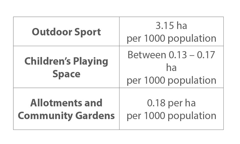
10.50 With regard to Children's Play Space, the Council will seek proposals which meet the Fields in Trust minimum standards as set out in Figure 10.4.
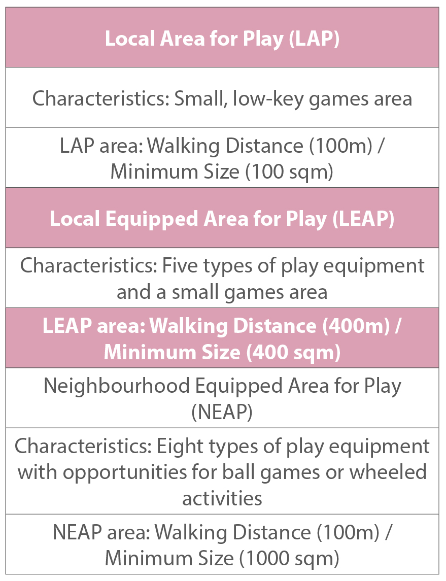
(1) FIGURE 10.4 FIELDS IN TRUST CHILDREN'S PLAY SPACE STANDARDS
10.51 The creation of new LEAPs will be prioritised at the Newham Estate, in line with the Borough's Play Area Strategy.
(13) POLICY 10.10: GREEN INFRASTRUCTURE
Development should adopt an integrated approach towards the provision of Green Infrastructure which enhances the Borough's network of multi functional green space including open space, parks, sport, recreational and play opportunities, flood storage, green roofs, habitat creation, woodlands, street trees, allotments, private gardens, footpaths, bridleways and cycleways, food growing and climate change mitigation.
New development will be required to maximise opportunities for the creation, restoration, enhancement, expansionand connection of Green Infrastructure and connection of the development site to the local Ecological Network. All major development proposals should seek to include elements of Green Infrastructure and Ecological Networks, such as but not limited to SuDS, allotments, street trees, green roofs, recreational areas, areas of new and existing natural habitat, green corridors through the site and waterbodies, and existing networks including Thames Chase Forest.
Where this is not possible, financial contributions to facilitate improvements to the quality and extent of existing Green Infrastructure in Brentwood Borough will be sought.
10.52 There is a need to better link formal and informal open spaces in the Borough to improve their wider use and value, as highlighted by the Brentwood Green Infrastructure Strategy (2015). Existing green infrastructure should be protected and enhanced and where opportunities arise, eg in conjunction with new development, additional provision made.
10.53 It is vital that the right infrastructure is in place to support future growth in the Borough, and this includes green infrastructure. There is a growing and compelling body of evidence substantiating the potential for green infrastructure to contribute to the economic, social and environmental well being of individuals and society. It can help facilitate high quality accessible landscapes, and bring the natural world into every neighbourhood, providing benefits for individuals, community health and wellbeing.
10.54 Policy 10.10 focuses on protecting and improving access to outdoor sports and recreational facilities, as well as accessible greenspace and provision of new facilities where needed. It is widely acknowledged that green infrastructure and open space has a major role to play in mitigating against and adapting to climate change, for example, urban cooling, encouraging sustainable travel choices and flood alleviation. Through the provision of green corridors the policy can help overcome habitat fragmentation and improve the ability of the natural environment to adapt to climate change and habitat loss by improving ecological connectivity.
10.55 The Council will promote local food growing by encouraging development proposals to include spaces for residents to grow their own food, safeguarding allotments and encouraging community gardens for food growing. Promoting local food growing in the Borough will have many benefits for residents. It will reduce the carbon footprint of food production by minimising CO2 emissions from transporting food and be beneficial for air quality by helping to reduce pollution. It supports healthy living by enabling residents make more sustainable food choices, protects local ecosystems and fosters community spirit and enterprise. The wider benefits of growing produce are identified in Brentwood Open Space, Sport and Leisure Assessment (2016) which highlights that providing opportunities for people to grow their own food contributes to sustainability, health and social inclusion.
(5) POLICY 10.11: AIR QUALITY
The Council will promote measures to improve air quality, particularly within designated Air Quality Management Areas, and will expect development proposals to reduce sources of air pollution.
Where the Council considers that air quality objectives are likely to be prejudiced or proposals fall within an Air Quality Management Area, applicants will be required to submit a detailed air quality assessment which sets out the impact the proposed development would have upon air quality. Planning permission will not be granted for development where there is likely to be a significant adverse impact on air quality. Air Quality Management Areas are shown on the Proposals Map.
10.56 All types of air pollution have the potential to harm the natural environment and human health. The Council has a responsibility for monitoring air quality within their area and where air pollution exceeds national standards, can designate Air Quality Management Areas (AQMA). When an AQMA is designated, the Council will produce an Air Quality Action Plan, which sets out what it intends to do about poor air quality. There are problems with air pollution in the Borough, particularly transport generated emissions. There are currently seven AQMAs in Brentwood Borough.
10.57 Monitoring data of air pollution in 2015 has shown that the air quality standard for nitrogen dioxide has been met since 2008 and so four of these seven areas no longer require an AQMA designation. The areas that will remain as AQMAs are: M25/Brook Street Roundabout; A12/Warescot Road/ Hurstwood Avenue/Ongar Road; and A128/A1023 Junction (Wilson's Corner).
10.58 The Council will seek to ensure that new development, particularly commercial, industrial and traffic generating uses do not result in unacceptable levels of air pollution. Developers should arrange pre-application discussions with the Council to ensure that air quality issues will be addressed when designing their proposals.
10.59 The Council promotes the use of renewable energy technologies to help tackle climate change, as set out in Policy 10.3 Sustainable Construction and Energy. Where biomass or CHP is proposed, the Council will require an emissions assessment prior to submission of a planning application. The emissions assessment must demonstrate that the plant would not significantly contribute to the deterioration of local air quality. The assessment must also demonstrate that other forms of renewable technology have been compared and assessed for their impact on local air quality.
POLICY 10.12: FLOODLIGHTING AND ILLUMINATION
Development proposals involving floodlighting or any other means of illumination (other than advertisements) will only be permitted where the scheme:
- is appropriate for the intended use;
- is energy efficiency efficient;
- provides the minimum level of light necessary to achieve its purpose;
- minimises losses to the night sky and does not give rise to any increase in sky glow; and
- ensures the appearance of the installation when unlit is acceptable.
Proposals must demonstrate adequate protection from glare and light spill particularly in sensitive locations, such as residential areas, sites of nature conservation interest, and have no adverse effect on amenity, highway safety, landscape or historic character.
Applicants will need to submit a full lighting strategy, proportionate to their application, specifying details of lights, their power and type, overall level and distribution of illumination and times of operation. Conditions may be imposed to restrict lighting levels and hours of use or require measures to be taken to minimise adverse effects.
10.60 External lighting can contribute to a healthy, safe environment, enhance the appearance of buildings and extend hours of operation of some activities eg sports, Insensitive or excessive illumination can, however, have a harmful impact on the local area and on the enjoyment of the night sky, particularly in open countryside. Excessive lighting can be detrimental to residential amenity, health and, in some circumstances, can be a statutory nuisance. Light pollution represents a wasteful use of energy, contrary to the aims of sustainable development.
10.61 Whilst local residents acknowledge that street lighting
for safety reasons is important (Brentwood Strategic Growth
Options, 2015), they place a high value on being able to see
the night sky and avoid unnecessary lighting (Brentwood
Neighbourhood Consultation, 2011). Proposals for lighting or
floodlighting of buildings, sport, leisure or other
facilities should take into account the effect of light and
lighting columns on the character and amenity of the
surrounding area.
They should also consider the effect of lighting in terms of
sky glow, glare and light trespass, effect on wildlife, and
any possible disturbance arising from the associated use.
Proposals should be unobtrusive in terms of the light source
and distribution of light, the aura created by the overall
illumination and appearance of any structures upon which
lights are mounted.
10.62 Where appropriate, the Council will control the location, form, timing and level of all external lighting and illumination.
10.63 Applicants should refer to the Institute of Lighting Engineers' guidance when considering the development and installation of lighting schemes. The Council will require a lighting strategy to accompany all full planning applications.
10.64 Lighting installations on Listed Buildings that materially affect their character, or illumination of some types of outdoor advertisements, will also require consent.
(5) Flood Risk and Drainage
10.65 Incidences of flooding have grown regionally as a result of increased development on flood plains, the use of impermeable surfacing, obsolete infrastructure and incidences of high rainfall, which are forecast to increase in number and intensity as a result of climate change. Developing inappropriately in areas at risk from flooding, can put property and lives at risk and therefore this policy seeks to ensure this does not happen.
10.66 Flood risk in Brentwood Borough is not extensive and largely limited to areas in very close proximity to local watercourses. Most flooding within the Borough is the result of rapid surface water runoff and ponding in areas with low lying roads. This means that drainage is equally important for avoiding flooding.
(14) POLICY 10.13: FLOOD RISK<
The Council will work in partnership with the Environment Agency, the Lead Local Flood Authority (Essex County Council) and the Internal Drainage Boards to manage and mitigate flood risk. All development proposals in areas at risk of flooding will need to submit a Flood Risk Assessment (FRA) in accordance with Sustainable Drainage Policy 10.14, commensurate with the scale of the flood risk and recognising all likely sources of flooding.
Proposed development will be required to avoid where possible flood risk to people and property and manage any residual risk, taking account of the impacts of climate change by:
- applying the Sequential Test, directing development to areas at lowest risk of flooding;
- if necessary, applying the Exception Test;
- safeguarding land from development that is required for current and future flood management;
- using opportunities offered by new development to reduce the causes and impacts of flooding; and
- demonstrating that the applicant has contacted the sewerage provider to identify whether the sewerage network has adequate capacity both on and off site to serve the development and to assess the need to contribute to any additional off site connections for the development. Where capacity is identified as insufficient, development will only be permitted if it is demonstrated that improvements will be completed prior to occupation of the development.
In areas designated as functional flood plains, development will only be permitted in accordance with national policy and guidance, and then only if:
- proposals are located in the lowest appropriate flood risk zone with regard to guidance set in the Brentwood Strategic Flood Risk Assessment as part of the sequential test;
- development would not constrain the natural function of the flood plain, either by impeding flow or reducing storage capacity; and
- development is constructed so as to remain operational even at times of flood through resistant and resilient design.
Where development is permitted within flood risk areas it must demonstrate that, where required, it will reduce fluvial and surface water flood risk and manage residual risks through appropriate flood mitigation measures including emergency planning and response.
These measures may include, but are not restricted to:
- land management, landscape and planting measures;
- SuDS, including source control techniques;
- strategic water storage;
- flow diversion and attenuation;
- Property Level Protection
10.67 The Sequential Test applies a hierarchical approach to avoiding and managing flood risk. In the first instance, this aims to locate development in a way that avoids flood risk to people and property, and manage any residual risk, taking account of the impacts of climate change.
10.68 The Brentwood Strategic Flood Risk Assessment (2010) maps flood risk zones in the Borough, with surface water flooding shown most notably on the A12 north west of Brentwood and on roads around Ingatestone. Incidences of fluvial (river) flooding are recorded along the eastern boundary of the River Wid and from Stondon Hall Brook and the River Roding to the north of the Borough. Areas at risk of fluvial flooding are mainly rural, and include low lying areas south of the A127 west and east of West Horndon.
10.69 The Surface Water Management Plan for Brentwood Borough (2015) used historical flood data from the flood risk assessment to determine the overall surface water flooding hotspots and then further modelling was carried out to understand the flooding mechanism and risks in more detail. The models were run with 30, 100 and 200 year rainfall events of various durations and the effects of climate change were investigated using the 100 year event. This identified a number of key areas as having significant flood risk which might benefit from mitigation options. Possible mitigation measures have been discussed and indicative costings provided.
10.70 Where a site-specific Flood Risk Assessment (FRA) is required this should be approved by the Environment Agency in line with criteria set by national policy and guidance. Development should be guided towards areas of lower flood risk through application of the Sequential Test and where applicable, an Exception Test will be required. The assessment will show the risk to the site in greater detail and advise on mitigation measures necessary.
10.71 Developers are encouraged to refer to the Environment Agency's Flood Risk Standing Advice for planning applicants and early pre-application discussion with the Council, lead local flood authority, and Environment Agency is advised.
(9) POLICY 10.14: SUSTAINABLE DRAINAGE
All developments should incorporate appropriate Sustainable Drainage Systems (SuDS) for the disposal of surface water, in order to avoid any increase in flood risk or adverse impact on water quality.
Applications should meet the following standards:
- QUANTITY- on brownfield developments SuDS features will be required so as to achieve a reduction from the existing runoff rate but must at least, result in no net additional increase in runoff rates. In all cases, including on brownfield sites, runoff should where possible be restricted to the greenfield 1 in 1 year runoff rate during all events up to and including the 1 in 100 year rainfall event with climate change. If it is deemed that this is not achievable, evidence must be provided and developers should still seek to achieve no increase in runoff from greenfield sites and a 50% betterment of existing run off rates on brownfield sites (provided this does not result in a runoff rate less than greenfield); and
- sites over 0.25 hectares in Flood Zone 1 will be required to submit a drainage impact assessment. Larger sites over 1 hectare in Zone 1 or all schemes in Flood Zone 2 and 3 must be accompanied by a Flood Risk Assessment (FRA).
- QUALITY - the design must follow the SuDS surface water management train, maximise source control, provide the relevant number of 'treatment stages' and identify how the 'first flush' will be dealt with, where feasible, through appropriate attenuation measures. Source control techniques such as green roofs, permeable paving and swales should be used so that rainfall runoff in events up to 10mm does not leave the site.
- AMENITY AND BIODIVERSITY - SuDS should be sensitively designed and located to promote improved biodiversity, an enhanced landscape and good quality spaces that benefit public amenities in the area.
- Redeveloped brownfield sites should disconnect any surface water drainage from the foul network.
- The preferred hierarchy of managing surface water drainage from any development is through infiltration measures, secondly attenuation and discharge to watercourses, and if these cannot be met, through discharge to surface water only sewers.
- When discharging surface water to a public sewer, developers will be required to provide evidence that capacity exists in the public sewerage network to serve their development.
10.72 Sustainable Drainage Systems (SuDS) are the primary means by which increased surface run-off can be mitigated. They can manage runoff flow rates to reduce the impact of urbanisation on flooding, protect or enhance water quality and provide a multi-functional use of land to deliver biodiversity, landscape and public amenity aspirations. They do this by dealing with runoff and pollution as close as possible to its source and protect water resources from point pollution. SuDs allow new development in areas where existing drainage systems are close to full capacity, thereby enabling development within existing urban areas.
10.73 Wherever possible, sustainable drainage systems techniques must be utilised to dispose of surface rainwater so that it is retained either on site or within the immediate area, reducing the existing rate of run-off. Such systems may include surface water storage areas, flow limiting devices and infiltration areas or soakaways. This approach is commonly known as the 'surface water management train' or 'source-to stream'.
10.74 The Brentwood Strategic Flood Risk Assessment (2011) recommends all sites in Flood Zone 1 over 0.25 hectares, be supported by a drainage impact assessment and for applications greater than 1 hectare, and all development within Flood Zones 2 and 3, be accompanied by a Flood Risk Assessment (FRA). The Brentwood Water Cycle Study (2011) recommends post development rates of runoff should not exceed pre-development runoff rates on all brownfield sites.
10.75 The Environment Agency introduced a new classification system in 2011 enabled by The European Water Framework Directive. This system allows for more rigorous and accurate assessment of water quality. Some water bodies will never achieve good ecological status, however, because they have been physically altered for a specific use, such as navigation, recreation, water storage or flood protection
10.76 The Flood and Water Management Act 2010 designates Essex County Council as the Lead Local Flood Authority and regional SuDS approval body. The mechanism for this process will be established between Brentwood Borough Council and the County Council. Applicants will need to prove compliance with the above drainage hierarchy as set out in the policy and ensure sustainable drainage has been adequately utilised, taking into account potential land contamination issues and protection of existing water quality, in line with national policy and guidance.
10.77 The applicability of SuDS techniques for use on potential development sites will depend upon proposed and existing land-uses influencing the volume of water required to be attenuated, catchment characteristics and the underlying site geology. Developers are encouraged to refer to the Strategic Flood Risk Assessment (which maps areas with potential for SuDS) and guidance provided by the Construction Industry Research and Information Association (CIRIA) for design criteria, technical feasibility and to ensure the future sustainability of the Borough's drainage system. Essex County Council have produced a SuDS Design Guide (2015) to help steer what is expected from development to complement national requirements and prioritise local needs.
Contaminated Land and Hazardous Substances
10.78 The Council wishes to ensure that sustainable development is achieved primarily through the regeneration and the redevelopment of previously developed sites. When considering the development of such sites the Council will consider the risk of pollution arising from contamination and the impact on human health, property, biodiversity and the wider environment. However, contamination is not restricted to previously developed land but also occurs on greenfield sites and can arise from natural sources as well as from human activities.
(3) POLICY 10.15: CONTAMINATED LAND AND HAZARDOUS SUBSTANCES
Development proposals involving the use, movement or storage of hazardous substances will only be permitted within Employment Areas and planning permission will only be granted for development on, or near to land which is suspected to be contaminated, where the Council is satisfied that:
- there will be no threat to the health of future users or occupiers of the site or neighbouring land;
- there will be no adverse impact on the environment and quality of local groundwater or surface water quality; and
- there would be no unacceptable adverse impacts on property.
The Council will require applicants proposing development on or near known or potentially contaminated land to submit a detailed site characterisation and tiered risk assessment and to identify any remedial measures that need to be carried out (including remedial treatment and monitoring arrangements), provided in a detailed Remediation Scheme. Evidence of remediation should be to the satisfaction of the relevant statutory regulators.
Planning permission will not be permitted for development on sites that lie near or adjacent to a hazardous substance site or notifiable installation, if the safety of the future occupiers of the development could be adversely affected by the normal permitted operations of the existing uses.
10.79 Where sites are known to be contaminated or where contamination is subsequently discovered, the Council will require any planning application to be accompanied by a detailed report appraising the levels and extent of contamination together with measures that will mitigate the contamination.
10.80 Where insufficient information is submitted with a planning application for a contaminated, potentially contaminated or suspected contaminated site, the Council will take a precautionary approach when making a decision.
10.81 In the context of development management, the Essex Contaminated Land Consortium's Land Affected by Contamination - Technical Guidance for Applicants and Developers (2014), provides detailed information on how to deal with land contamination. This provides guidance on how planning conditions may be used to secure suitable remediation when dealing with planning applications where contaminated land is identified.
10.82 The Planning (Hazardous Substances) Act 1990 aims to prevent major accidents and limit the consequences of such accidents. In considering any planning applications for development which may involve hazardous substances the Council will therefore need to be completely satisfied that the proposal will not constitute a hazard to existing communities or the local environment. Similarly, existing consents will be an important consideration in the determination of sensitive uses such as housing. In appropriate cases the Council will therefore consult and liaise with the Health and Safety Executive to minimise potential risks.
10.83 Hazardous substances are defined by the Planning (Hazardous Substances) Regulations 1992. The Council is required to ensure that land use policies maintain and secure appropriate distances between establishments where hazardous substances are present and residential areas, areas of public use and areas of national sensitivity or interest. The Council considers that it would be inappropriate to locate new development on or near to establishments where hazardous substances are present where this would harm public safety.
10.84 Similarly, it would be inappropriate to grant planning permission for development proposals to expand existing sites handling or processing hazardous substances where this would harm public safety. Should a developer have reason to believe a development site is contaminated then they must consult the Council as early as possible before an application is submitted.
10.85 Certain sites and pipelines are designated as notifiable installations by virtue of the quantities of hazardous substance stored or used. Where development is proposed within the consultation distance of notifiable installations, the Council is required to consult the Health and Safety Executive on the suitability of that development in relation to the risks that the notifiable installation might pose to the surrounding population.
(3) Institutional Buildings
10.86 An important element of creating sustainable communities is the provision of institutional uses such as such as schools, medical centres, hospitals and places of worship close to where people live and work. The potential impact of new facilities or the loss of existing ones needs careful consideration.
10.87 Infrastructure for communications is an important facet of a thriving community in the 21st Century, however the Council wish to ensure that the provision of essential telecommunication infrastructure is sympathetically installed, particularly in the Boroughs sensitive areas.
(1) POLICY 10.16: BUILDINGS FOR INSTITUTIONAL PURPOSES
Redevelopment, change of use or new buildings for Institutional Purposes will be permitted where the Council is satisfied that:
- the proposal is in close proximity to appropriate social facilities;
- the site is easily accessible by public transport, walking and cycling;
- the proposal will not have unacceptable adverse impacts on the transport network and parking provision is adequate; and
- the type, scale and character of the proposed development would be appropriate in the context of the surrounding area.
10.88 By their nature institutional uses can generate considerable traffic and other activity. The siting of such a facility, therefore, needs to be arefully considered in terms of impact on the transport network and on neighbouring properties. Any site should be easily accessible, particularly by public transport, walking and cycling. Residents or users of such buildings may benefit from being near social or community facilities, eg shops, post office, medical facilities, and community halls.
10.89 As with other development or changes of use, there should be no loss of existing residential accommodation.
Communications Infrastructure
10.90 The Council recognises the growing importance of modern, effective telecommunications systems to serve local business and communities and their crucial role in the national and local economy. There is a Borough wide commitment to securing rural broadband. However, by its nature, telecommunications development has the potential to have a significant impact on the environment and raises issues of visual and residential amenity. Mast and site sharing, using existing buildings and structures and a design led approach, disguising equipment where necessary, can help address these concerns.
POLICY 10.17: COMMUNICATIONS INFRASTRUCTURE
Planning permission will be granted or prior approval given for essential telecommunication masts, equipment and associated development provided:
- they are sited and designed in a manner that respects the character and appearance of the area and is not harmful to visual amenity;
- evidence is provided to demonstrate, to the Council's satisfaction, that the possibility of mast or site sharing has been fully explored;
- evidence is provided to show, to the Council's satisfaction, that there are no suitable alternative sites for telecommunications development available in the locality including the erection of antennae on existing buildings or other suitable structures; and
- evidence is provided to confirm that the proposals conform to the latest national/international guidelines on radiation protection and would cause no harm to highway safety.
10.91 The objective of Policy 10.17 is to ensure the right balance is struck between providing essential telecommunications infrastructure and protecting the environment and local amenity. Planning applications must be accompanied by detailed supplementary information which provides the technical justification for the proposed development including the area of search, details of any consultation undertaken, the proposed structure and measures to minimise its visual impact.
10.92 Although the impact from telecommunications equipment on health is a source of public concern, the Government has indicated that the planning system is not the place to determine health safeguards. However, the Council will nevertheless require all applicants to demonstrate their proposed installation complies with the latest national and international guidelines. This currently requires applicants to demonstrate they comply with the International Commission of Non-Ionizing Radiation Protection (ICNIRP) which should take into account the cumulative impact of all operators' equipment located on the mast/site.