Draft Local Plan
2. Context
(2) Planning Policy Context
Legislation and Planning Policy
2.1 The Draft Plan covers the whole of Brentwood Borough and has been prepared in light of the Planning and Compulsory Purchase Act 2004, the Localism Act 2011 and the Town and Country Planning (Local Planning) Regulations 2012. It takes account of the National Planning Policy Framework (2012), other national planning policies (such as those for Travellers, schools, and parking), and planning practice guidance.
Localism Act
2.2 The Localism Act introduced major changes to the planning system, abolishing regional plans and introducing a new tier of neighbourhood planning. The East of England Plan was revoked in January 2012. The system remains 'Plan led', which means the Local Plan provides the starting point for taking decisions on new development.
2.3 In future the development plan will comprise the Local Plan together with any neighbourhood plans that are produced.
National Planning Policy Framework and Planning Practice Guidance
2.4 The National Planning Policy Framework states that each local planning authority should produce a Local Plan for its area which can be reviewed in whole or in part. Additional planning documents should only be used where justified. This differs from the previous Local Development Framework system with its suite of documents including an overarching Core Strategy.
2.5 The Department for Communities and Local Government (DCLG) launched the planning practice guidance web-based resource in 2014 to bring together guidance for England in an accessible and usable way. This guidance is intended to assist practitioners and updated regularly. Ultimately the interpretation of legislation is for the Courts but this guidance is an indication of the Secretary of State's views. This includes guidance on the production and deliverability of local plans.
Local Economic Partnership
2.6 The South East Local Enterprise Partnership (LEP) is the business-led, public/private body established to drive economic growth across Essex, Kent and East Sussex. Whilst the LEP has no statutory land use planning powers, it is responsible for determining local economic priorities and undertaking activities to encourage economic growth and local job creation.
County Policy
2.7 Various strategies have been produced by Essex County Council that form part of the development plan for Brentwood Borough. These include transport strategies, education plans, economic growth priorities, and minerals & waste policy for Essex.
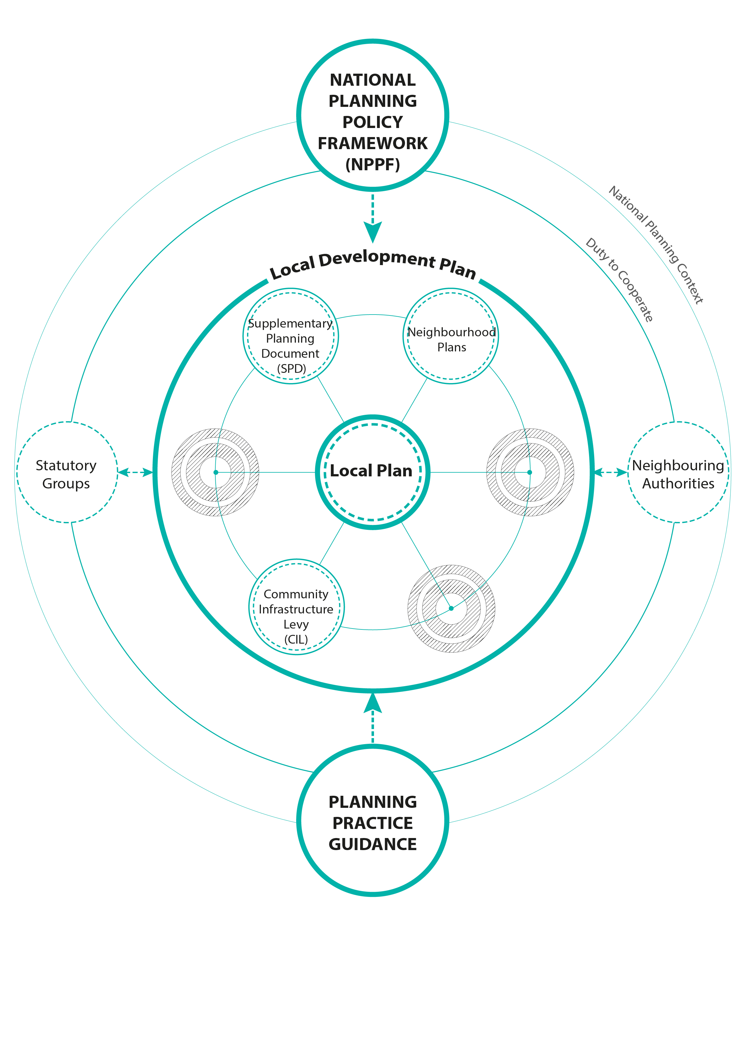
Local Development Plan
2.8 Brentwood's Local Development Plan is made up of various adopted planning policy, including supplementary planning documents, masterplans and community produced Neighbourhood Plans. The Local Plan is the key document holding it all together. This Draft Plan is an important step towards being able to eventually adopt a new Local Plan. All documents sit under national policy and guidance.
2.9 Neighbourhood Plans enable communities to establish general planning policies for the development and use of land in a neighbourhood. They can be detailed, or general, depending on what local people want.
2.10 For more information about the Local Development Plan, Neighbourhood Plans and the national context please visit www.brentwood.gov.uk/localplan
Corporate Plan 2016-2019
2.11 This Draft Plan has been prepared in the context of the Council's recently adopted Corporate Plan 'Vision for Brentwood' 2016-19. This identifies the following overarching priorities:
-
Environment and Housing Management
-
Community and Health
-
Economic Development
-
Planning & Licensing
-
Transformation
2.12 The corporate plan commits the Council to delivering a new Local Development Plan that will shape the way our Borough will change over the next fifteen years. It also commits to get the best outcome and achieve a good balance for residents and businesses in a way that celebrates Brentwood's unique history and quality of life; both within the borough and influencing the outcome of regional developments that will affect Brentwood residents.
2.13 The Local Plan will be a key vehicle for delivering several corporate plan objectives.
(8) Supporting Documents
(1) Pattern Book & Other Documents
2.14 A Pattern Book has been prepared to serve as an illustrated guide to supplement the Draft Plan. It contains maps and figures depicting some of the issues considered as part of the plan making process and proposed future planning strategy. In addition, there are other supporting documents including site allocation maps and a draft proposals map.
(109) Evidence Base
2.15 It is essential that the Local Plan is informed by robust and up to date evidence. Evidence includes technical studies on a range of subjects, such as economy, environment, housing and leisure. Published evidence can be found on the Council's website at www.brentwood.gov.uk/localplan.
2.16 In addition, several pieces of evidence are being undertaken alongside Local Plan preparation to inform policies as they are being developed and ensure the Council is able to produce a Plan as quickly as possible.
(30) Sustainability Appraisal
2.17 Sustainability Appraisal (SA) is an exercise carried out at key stages in the plan making process and a statutory requirement. It considers potential impacts of the Plan on economic, social and environmental considerations, and incorporates the requirements of the European Directive on Strategic Environmental Assessment.
2.18 Versions of Sustainability Appraisal have been carried out at various stages of the plan making process. Appraisal recommendations at each stage have informed the production of this Draft Plan.
2.19 Alternative options and the assessment of sites will continue to be tested through the appraisal.
2.20 An appraisal accompanies the Draft Plan and is available for public comment. This appraisal and previous versions can be found on the Council's website at: www.brentwood.gov.uk/localplan.
(1) Habitats Regulation Assessment
2.21 In accordance with Regulation 61 of the Conservation of Habitats and Species Regulations 2010 a Habitats Regulation Assessment (HRA) screening has been carried out to determine whether this Draft Plan is likely, either alone or in combination with other plans and projects, to have a significant effect upon the international sites identified. The results of the HRA have yet to be confirmed, however no significant effect is anticipated.
(27) Duty to Cooperate
2.22 Local planning authorities are required to cooperate on strategic planning matters. The Council has been working with and will continue to work with its neighbours on cross boundary issues. In addition to adjoining authorities, the Council is also required to cooperate with other authorities such as Essex County Council and those in the wider region where appropriate. We will also cooperate with utility providers and other statutory bodies such as Highways England and the Environment Agency.
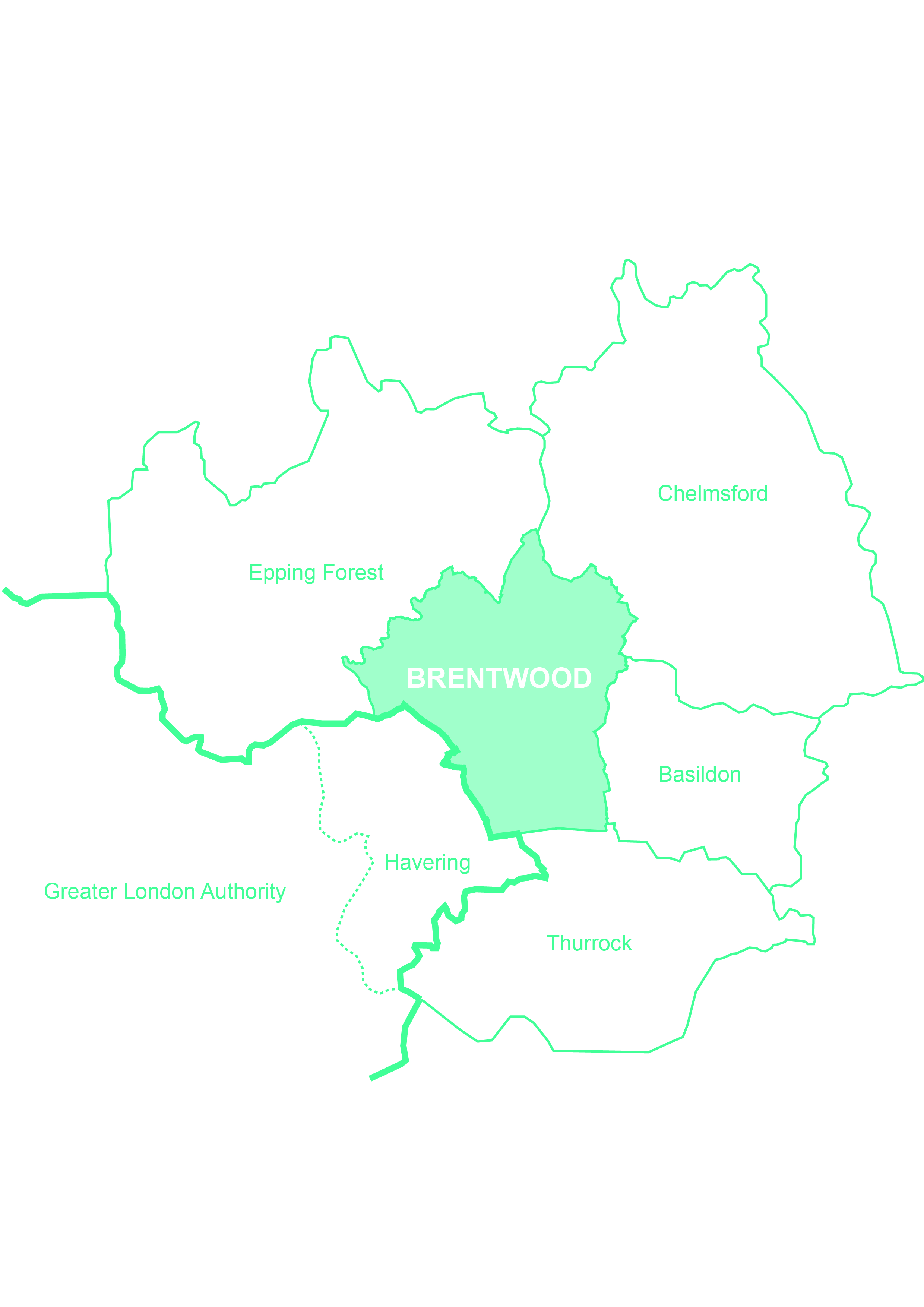
FIGURE 2.2: Adjoining Local Authorities
Borough Key Characteristics
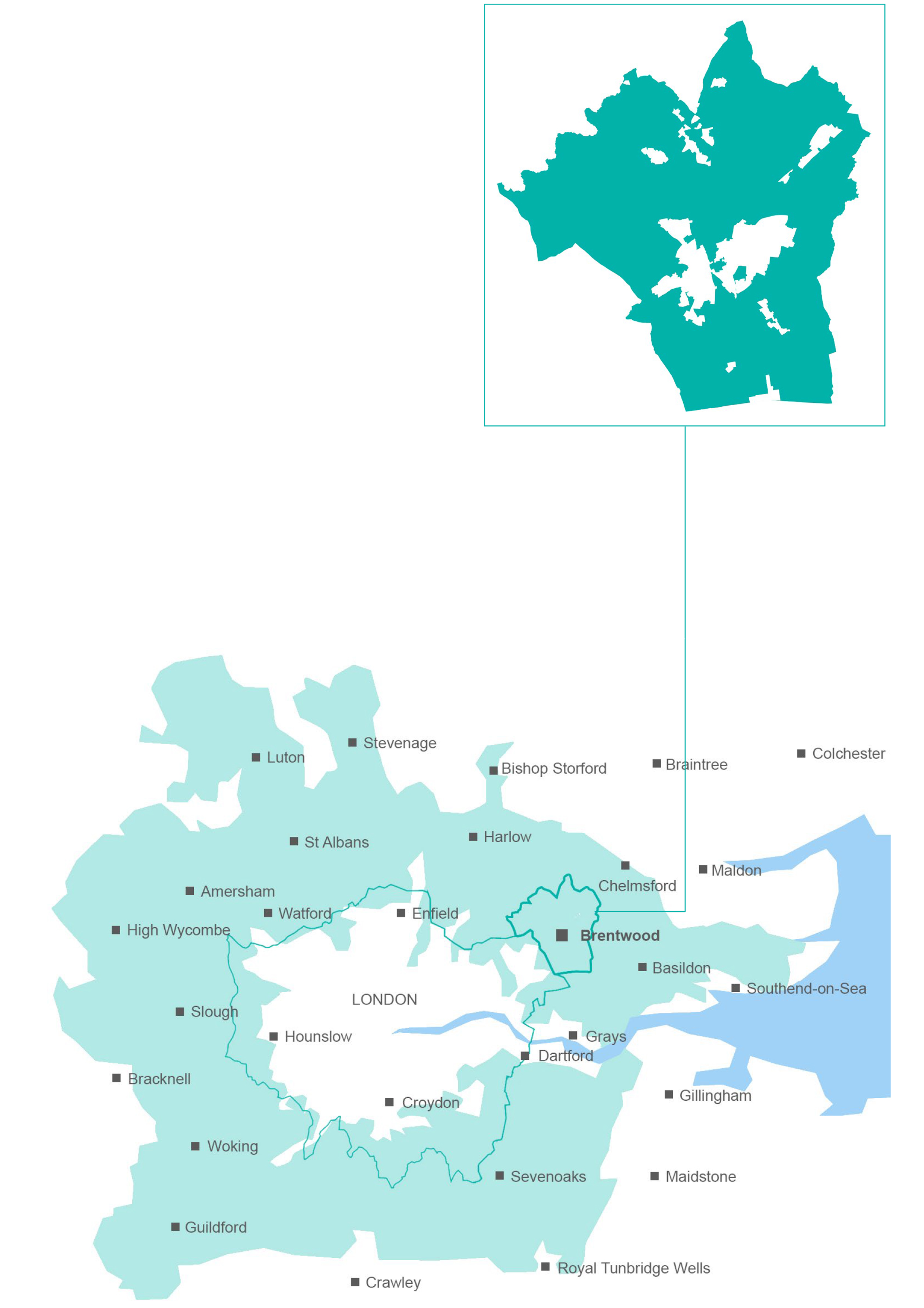
2.23 Located in the south-west of Essex and east of Greater London, Brentwood Borough offers the best of both worlds - high quality natural environment and access to London. The Borough is centred on the market town of Brentwood, which is surrounded by some suburban areas and villages set amongst the Essex countryside. Excellent road and rail links provide quick access to central London and the wider UK transport network. These qualities make the Borough an extremely attractive place to live, work and visit.
2.24 The following paragraphs set out the context of the Borough, important to consider in light of planning for its future. This context is also further explored in the strategy and policies of the Plan. While its many qualities make the borough attractive, they can also result in constraints because of the demand on services, like travel congestion, education capacity and access to health services. These are equally important to consider when planning for the borough's future.
2.25 Figures 2.3 and 2.4 depict some of these key characteristics, set within a storyboard to help explain how these have to be considered as part of the Plan making process.
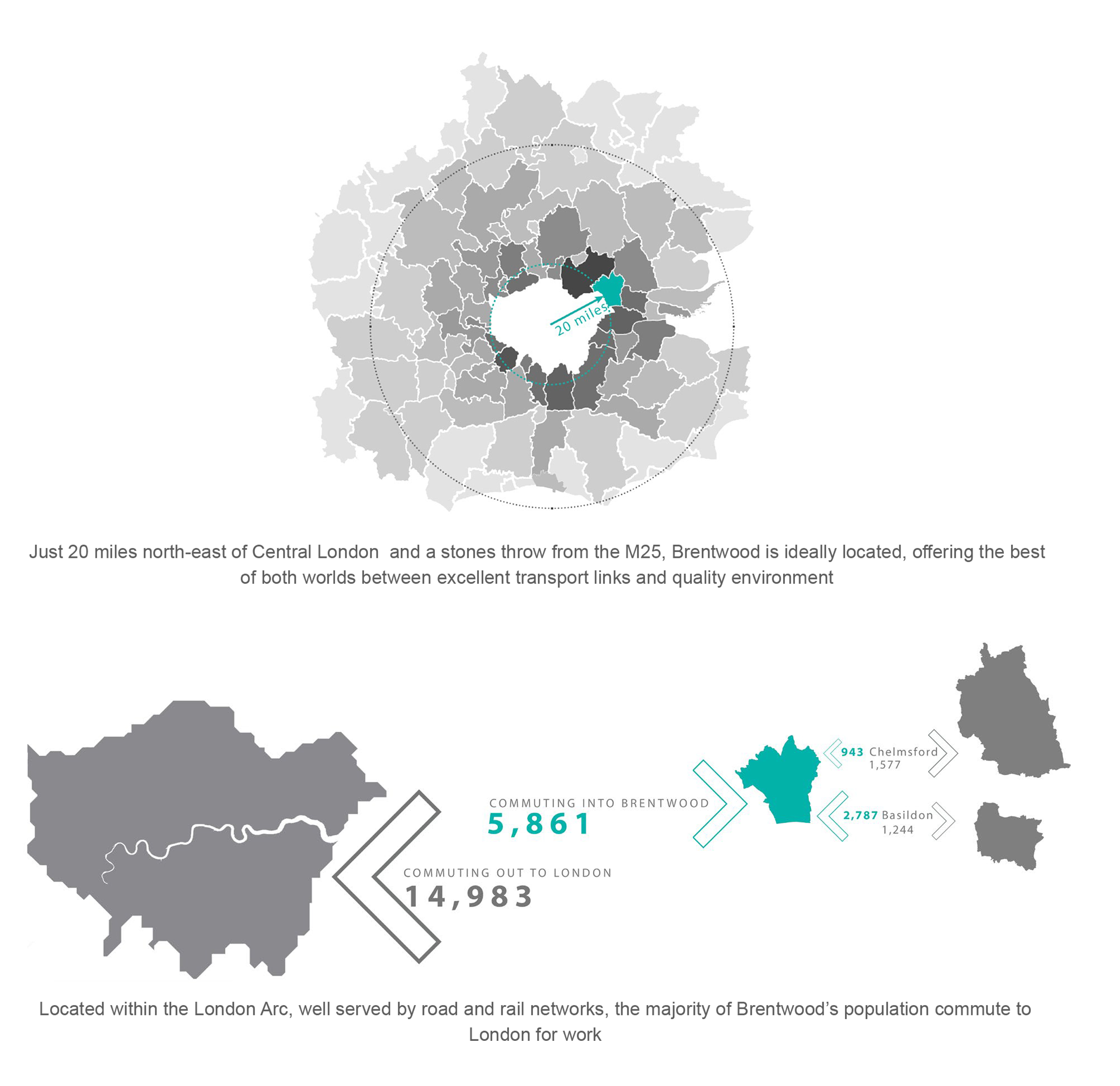
FIGURE 2.3: Our Story - Location
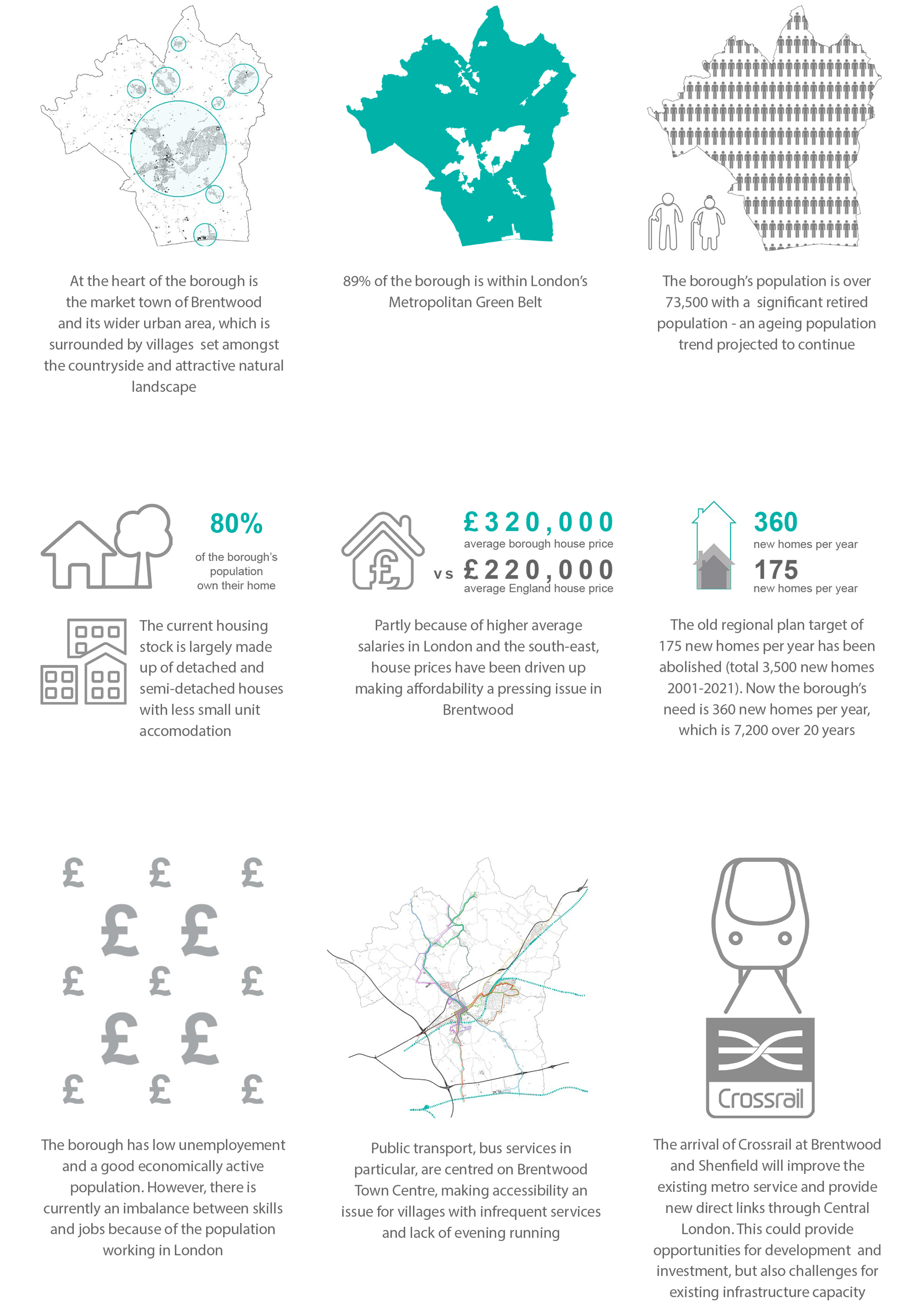
FIGURE 2.4: Our Story - Issues
(3) Population and Housing
2.26 Brentwood Borough has a total area of approximately 15,300 hectares. The population in 2011 was 73,601 (Census), of which approximately 70% live in Brentwood town. The 2014 mid-year population estimate shows that this has increased to 75,600.
2.27 The proportion of the population from black and minority ethnic groups in the borough is well below average for the Eastern region and England. The largest non-white minority ethnic group is made up of people of Asian origin.
2.28 Brentwood is one of the most affluent areas in England, within the least deprived 10% of the country.
2.29 There are just over 32,000 homes in Brentwood Borough. The main property type is detached and semi-detached houses, which at almost 63% total stock is higher than the national level (53%). The main property size of stock is 3-bedrooms (35%), followed by 2-bedrooms (25%) and 4-bedroom homes (23%).
2.30 House prices in the borough are very high. This can cause issues preventing people from buying homes with entry level housing often too expensive for many newly forming households and the need for a significant deposit.
(1) Economy and Employment
2.31 Brentwood Borough has a successful and buoyant local economy, providing for over 30,000 jobs. Banking and finance is the main business sector followed by distribution/hotels/restaurants and public services. The local business structure is dominated by micro (1-10 employees) and small businesses (11-49 employees), while entrepreneurial activity is high.
2.32 Office employment areas are mainly in Brentwood town centre, Brentwood station area and Warley Business Park. Major employers include BT, Canon, Countryside Properties, Ford and LV Insurance.
2.33 Despite the Borough's rural character employment in agriculture is below the national average, as is manufacturing.
2.34 Three quarters of the Borough population is of working age. This proportion has fallen over time as the population ages. There continues to be a rise in the number of people of working age in the Borough, but a disproportionate rise in the number of older people. Average weekly wages for those who live here but work elsewhere are higher than for those who work in the Borough. A high proportion of people are employed as managers, senior officials, and in associated professional and technical occupations, reflecting the number of people commuting to places like central London.
2.35 New employment land in the Borough is constrained by its Green Belt location. The current availability of undeveloped allocated employment land is limited.
Retail and Shopping
2.36 Brentwood Borough offers a wide range of retail and commercial leisure facilities. The main shopping area, Brentwood Town Centre, is centred on the High Street. The Town Centre provides a range of retail, restaurants and cafes, including a quality independent niche shopping offer.
2.37 District centres at Shenfield Hutton Road, Ingatestone High Street, Brentwood Station Warley Hill, and many smaller local parades and individual shops serve residential areas and villages. Each centre plays an important role providing a range of essential local services.
Arts and Community
2.38 Brentwood Borough has a strong and dedicated arts community. There are over 70 arts organisations and societies delivering arts events throughout the year. Participation numbers in the Borough are high with many people regularly taking part in an arts activity in their leisure time.
2.39 Local facilities, such as parish, village and neighbourhood halls provide for a range of community and cultural activities, such as play groups, clubs, social activities and public meeting space.
2.40 There are nine Parish Councils covering much of the borough's rural areas. However, the majority of the population live in un-parished areas, such as the wider Brentwood urban area.
Sport and Leisure
2.41 The Borough benefits from extensive open areas for informal recreation. South Weald and Thorndon Country Parks provide 324 hectares of open space along with numerous publicly accessible playing fields, parks, woodlands and amenity greens.
2.42 Brentwood Leisure Centre and Shenfield Sports Centre, along with privately run sports and leisure facilities, are the focus for indoor sport and recreation. In addition, excellent sporting facilities are provided at several schools and can be accessed for public use.
(4) Health and Wellbeing
2.43 Health is defined as a state of complete physical, mental and social well-being and not merely the absence of disease or infirmity. The Council is working with partners to achieve a Healthier Brentwood, so that people can enjoy good health and a sound and vigorous mentality.
2.44 The health of Borough residents is generally better than the England average according to Public Heath England. Life expectancy is above average. Levels of obesity, diabetes and drug misuse are below the national average.
2.45 Brentwood residents have to travel outside the Borough to access main hospital facilities including accident and emergency. However, the Borough benefits from a small NHS community hospital in Brentwood and other private medical facilities. GP surgeries are generally at capacity. NHS England has identified an additional need for GPs subject to the location of future development.
2.46 Basildon & Brentwood Clinical Commissioning Group (CCG) are responsible for planning, designing, buying and performance managing NHS services in the area. This includes a wide range of services such as most planned hospital care, rehabilitation care, urgent and community care, community health services and mental health and learning disability services.
(2) Education and Schools
2.47 Borough residents have higher than average levels of educational attainment when compared to both the rest of England and East of England. The Borough has higher than average levels of school pupils achieving five good GCSEs and proportion of population with degree level education or equivalent. There is a lower than average proportion of population with no qualifications.
2.48 The Borough has many well performing schools and colleges. Essex County Council is the local education authority although many schools are now self-governing, managing their own budgets and employing their own staff. There are also several independent or private schools in the Borough. As academy schools are being encouraged it will be important to work with partners to ensure adequate education provision is available to existing and future local residents.
2.49 Primary schools in the Borough are generally at capacity, particularly within the Brentwood urban area, and some have limited physical space to expand. Secondary schools are generally performing with spare capacity.
(9) Transport and Travel
2.50 Brentwood Borough is well connected to road and rail networks. Major roads such as the M25, A12 and A127 run through the Borough and the M11 and Stansted Airport are within easy reach. Despite good accessibility and location, traffic congestion is one of the main issues affecting quality of life and local economic performance. Brentwood has a very high level of car ownership compared to the national average. Without alternative means of transport the use of cars will continue to be an essential factor in access to services, employment and leisure. Therefore the delivery and encouragement of sustainable transport alternatives is essential.
2.51 There are four rail stations in the Borough: Ingatestone, Shenfield and Brentwood stations on the Great Eastern Main Line to London Liverpool Street, and West Horndon station on the London Fenchurch Street to Southend line. Fast train services stop at Shenfield and Ingatestone; metro services stop at Brentwood and Shenfield. In future Crossrail will replace the existing metro service, stopping at Brentwood and terminating at Shenfield. Crossrail will provide the Borough with an improved train service, increased capacity, station improvements and new direct links to Central London, Heathrow Airport and the West.
2.52 Bus services are centred on Brentwood Town Centre with links to other parts of the Borough and centres outside. However, bus services in more rural areas are limited, particularly at off-peak times.
2.53 The percentage of those who cycle to work is below the national average, but more people walk to work than average. Encouraging sustainable travel patterns is of key importance.
(6) Utilities, Telecoms and Media
2.54 Power, gas and water networks will need to be considered when planning the Borough's future. The Council is working with energy and water providers as part of the plan-making process. In addition, new development will require connections to telecoms and broadband networks.
2.55 Broadband internet connection and superfast speeds have become an essential everyday utility for homes and businesses across the country. Coverage in Brentwood varies between urban and rural areas. Essex County Council has committed to a significant broadband infrastructure upgrade with telecoms partners. Broadband speed is an important issue for the UK economy and international competition.
(2) Environment, Heritage and Resources
2.56 The Borough has significant built and natural heritage: 500+ Listed Buildings, 13 Conservation Areas, 12 Scheduled Ancient Monuments, 100s of sites of archaeological interest, accessible countryside and parks, varied landscapes and numerous Local Wildlife Sites. Together, these features provide an attractive, sought after environment for residents, businesses and visitors.
2.57 Development, whether existing or new, invariably places demands on the environment. Among these are unsustainable use of resources (materials, water, energy), waste disposal issues, pollution (of air, water or soil) and loss of or harm to wildlife habitats, historic buildings and landscapes.
2.58 The Borough, in common with other places, depends on fossil fuel energy for homes, business and transport, and other finite resources, such as water and land. Fossil fuel energy gives rise to greenhouse gas emissions and climate change and in future may not be readily available in the way it has been in the past. We therefore need alternatives, including renewable energy and local supplies. Agricultural land grades describe the best and most versatile land, a national resource that needs protecting. Brentwood contains grades 2 and 3a land.
2.59 This Plan places a high priority on the prudent use and good management of resources and effective protection for the environment. Both the form and location of future development and how buildings and land are used are fundamental to safeguarding those qualities which make Brentwood special and ensure these continue to be available for future generations to enjoy.
(3) Green Belt
2.60 Although not an environmental designation, all of the borough's countryside lies within Metropolitan Green Belt. That equates to 89% of the Borough, the sixth highest in England by percentage of total area. This helps protect much of our high quality environment but also constrains development opportunities, making it difficult to meet development needs in full.
2.61 This Plan recognises the high quality of the Borough's natural environment. The Green Belt is a valuable asset because it protects this character.