Draft Local Plan
5. Spatial Strategy
(3) What is a Spatial Strategy?
5.1 The Spatial Strategy for Brentwood Borough provides the context for managing change and shaping how the area develops in future. The strategy sets out the level and location of development, highlights key areas of change up to 2033, and provides the basis for delivering strategic objectives, planning policies and land allocations.
5.2 This overarching strategy applies to all development in the Borough. The Plan's vision, strategic objectives and planning policies are all underpinned by the spatial strategy. Spatial Policies within this chapter set out the aims of the strategy. Core and Development Management Polices that follow provide the framework for its delivery.
(9) Evolution of the Spatial Strategy
5.3 Before setting out the proposed spatial strategy for the Borough it is important to consider how this has evolved in recent years through Local Plan consultation and changing national planning context.
2009 - 2011
5.4 As part of the Core Strategy Issues and Options consultation (2009) the Council sought public views on four spatial options to guide future development in the Borough at targets required by the (then) regional plan, the East of England Plan (175 new homes per year and job growth to match). When identifying available land to meet development needs evidence suggested targets could be fully met on brownfield land within urban areas. The four spatial options were:
-
Option 1, Centralised Growth: Focus development in and around the Brentwood urban area.
-
Option 2, Transport Corridor-led Growth: Development in central areas but also areas with strategic transport connections, such as major highways and rail stations.
-
Option 3, Semi-Dispersed Growth: Development in and around Brentwood and main Borough villages.
-
Option 4, Dispersed Growth: Development at all settlements across the Borough.
5.5 Consultation responses suggested a preference for options 1 & 2. This was supported by technical evidence as the most sustainable strategy for future growth.
5.6 As part of the Your Neighbourhood Consultation (2011) specific sites suggested to the Council for development were made available for public comment. This expanded on the spatial options of 2009 to show where land could be available for development. This was still within the context of the East of England Plan development targets.
2013 - 2015
5.7 The Council's Preferred Options consultation (2013) proposed a spatial strategy that derived from option 2, transport-led growth. This focused growth in Brentwood, Shenfield and West Horndon, along with suitable developed sites in the Green Belt and brownfield development in other villages.
5.8 Importantly this was a variation on spatial option 2 because by this time the East of England Plan had been abolished leaving the requirement to plan for 'objectively assessed needs', which evidence suggested were significantly more than the old regional plan target, around 360 new homes per year. However, at this time it was still unclear how other plans going through public examination would be assessed if they proposed to exceed the old regional target but not fully meet objectively assessed needs.
5.9 Proportionately more growth at West Horndon was proposed because of the comparative capacity for growth in that location, and less growth in Ingatestone because of capacity and land constraints. The strategy also considered lack of capacity in the Brentwood urban area and north of the Borough in terms of infrastructure such as roads (due to congestion), primary schools, GP facilities and a higher landscape value. Consequently it was proposed that the Borough meet a higher development need than the abolished regional target, but due to capacity constraints not meet the full objectively assessed housing need.
5.10 The Council's Strategic Growth Options consultation (2015) was prepared in light of lessons learned after summer 2013, such as consideration of consultation representations and a clearer view of Planning Inspectorate decisions on other authority plans regarding need. It became clear that other authorities not meeting their full development needs were being found 'unsound' by the Planning Inspectorate on the basis that they did not conform with the NPPF.
5.11 The Growth Options document set out the continuing narrative of the spatial options that had gone before but now within the context of meeting full objectively assessed needs, specifically housing needs of 362 new homes per year.
5.12 For the purpose of considering approaches to future development the document set out that the whole Borough could be divided into three broad areas drawn up to focus on existing transport corridors. The three areas were distinguished as having different characters and issues for consideration and so could potentially accommodate different approaches to growth. However, it was made clear that each area should not be considered in isolation. The three areas were:
- North of the Borough
- A12 Corridor
- A127 Corridor
5.13 The fundamental issue facing the Borough through this spatial strategy evolution is the finite capacity of brownfield sites within urban areas. Higher development needs put pressure on the release of Green Belt to meet those needs in full.
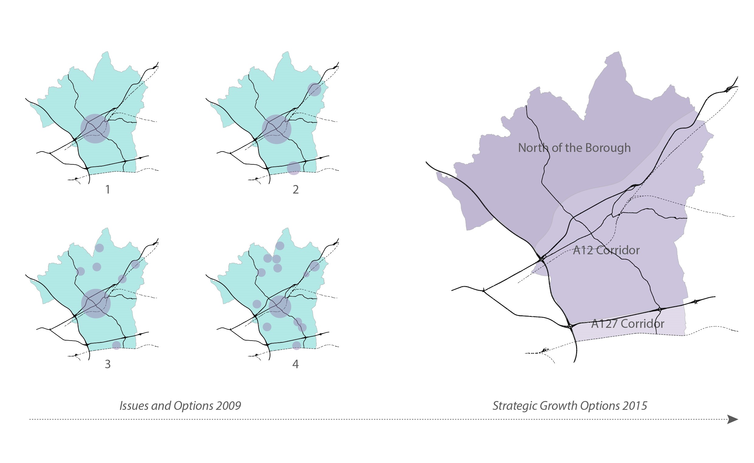
FIGURE 5.1: Historic Spatial Options and Broad Areas
(59) Draft Plan Spatial Strategy
5.14 Following consideration of representations made in response to the Strategic Growth Options consultation it is evident that splitting the Borough into three areas does not sufficiently consider rural areas in the south of the Borough. The North of the Borough as set out in the Growth Options document is made up of villages set amongst rural surroundings. In the same way, the south of the Borough contains villages surrounded by countryside. For the purpose of the Draft Plan and Local Development Plan going forward the Borough will be split into four areas. This is consistent with the emerging spatial strategy regarding the Borough's character and clearly defines the two transport corridors as separate areas. Figure 5.2 depicts this approach.
- Rural North
- A12 Corridor
- Rural South
- A127 Corridor
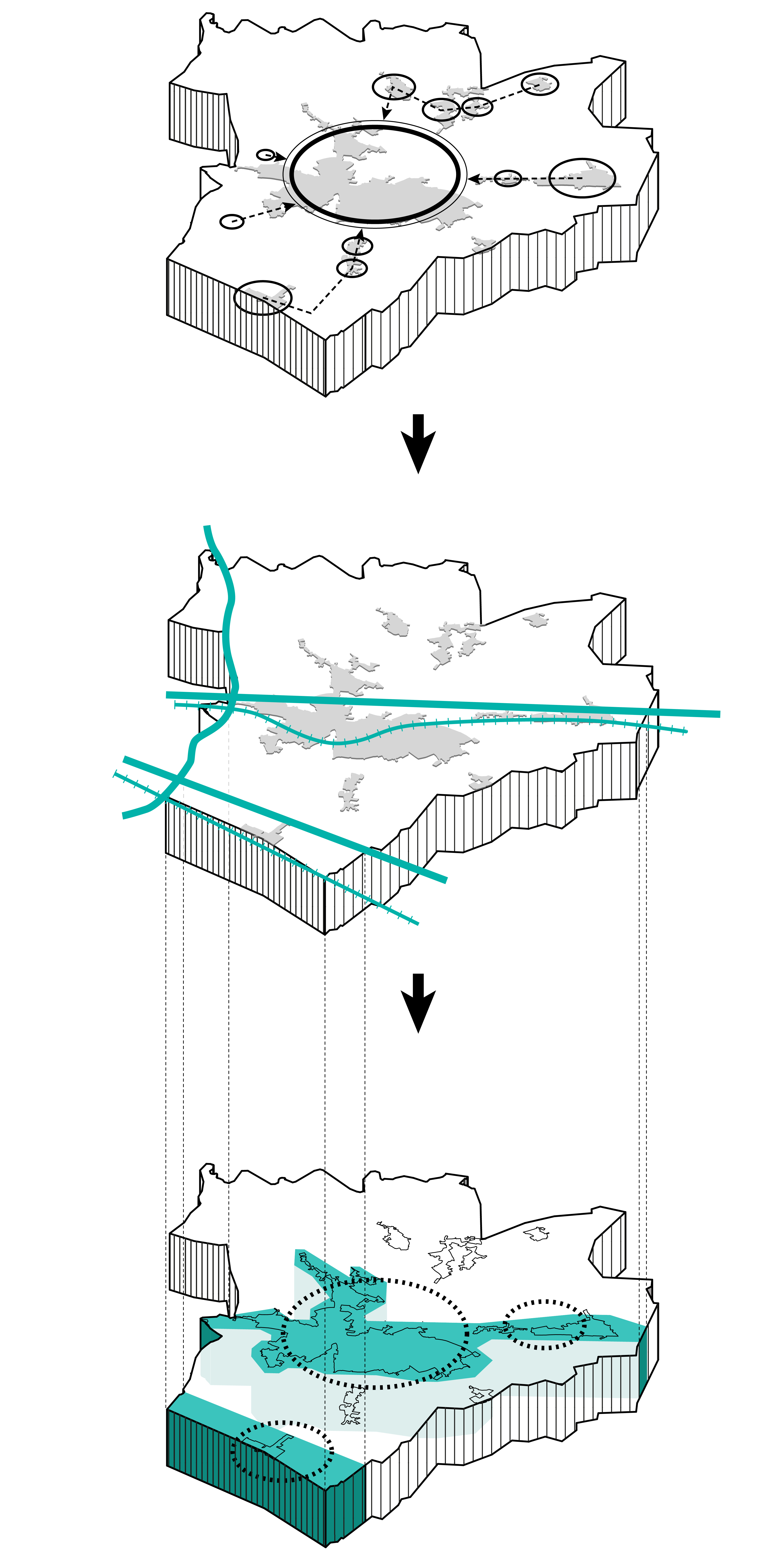
FIGURE 5.2: Our Approach
5.15 Ultimately the spatial strategy aims to achieve the right balance between retaining local character and meeting development needs, as depicted in Figure 5.3.

FIGURE 5.3: Development Needs and Borough Character
(40) Sequential Land Use
5.16 The proposed spatial strategy considers appropriate land uses sequentially in line with guidance and best practice. If Green Belt land needs to be considered to help meet needs then the Council believe this should only be so after all suitable and available brownfield locations are brought forward first. In order to guarantee this a sequential list of sites and land types are proposed to meet development needs for new homes and jobs as set out in Figure 5.4.
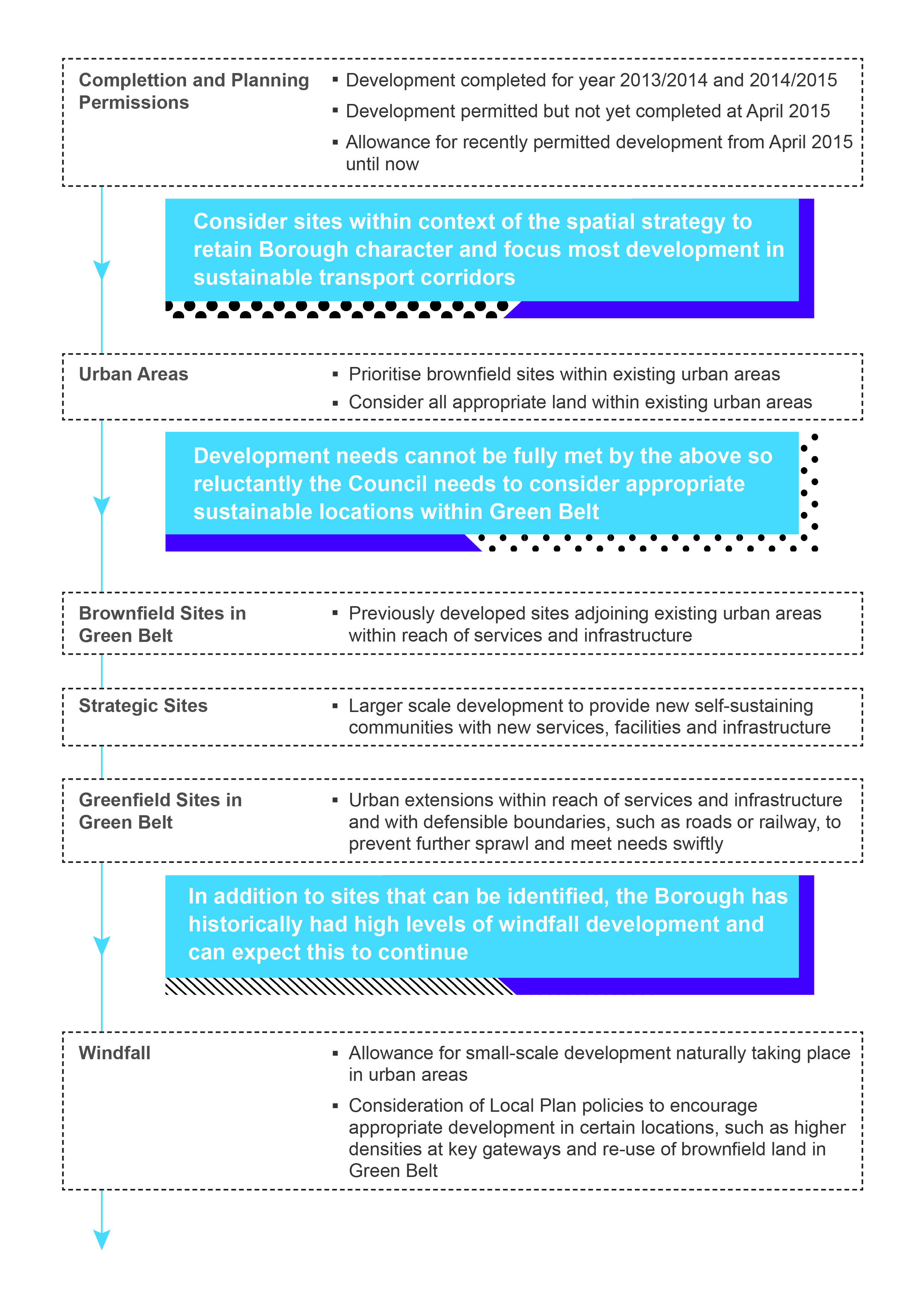
(19) FIGURE 5.4: Sequential Selection of Sites
(195) POLICY 5.1: SPATIAL STRATEGY
The Borough's distinct local character will be protected and enhanced while we foster sustainable communities by focusing new development on land within the Borough's Transport Corridors. Brentwood and Shenfield will be the main focus for development in the A12 Corridor supported by two strategic allocations in the A127 Corridor, bringing forward new homes and jobs.
To meet local needs fully there will be limited release of Green Belt for development within transport corridors, in strategic locations to deliver self-sustaining communities with accompanying local services, and urban extensions with clear defensible physical boundaries to avoid further sprawl and provide development swiftly.
Limited development, including infilling where appropriate, will take place in villages within rural areas at a level commensurate with services and facilities available and which maintains local amenity and distinctiveness. All development sites will be identified having regard to whether they:
- are accessible to public transport, services and facilities;
- will have no significant impact on the Green Belt, visual amenity, heritage, transport and environmental quality including landscape, wildlife, flood-risk, air and water pollution; and
- are likely to come forward over the Plan period.
Policy 5.1 contributes towards objectives SO1 and SO2.
5.17 The preferred approach seeks to achieve the right balance between conserving the Borough's character and deliver development which meets the needs of all those who live, work and visit. Key considerations are land availability, development needs, scale of growth proposed, the existing settlement pattern and hierarchy and capacity of places to accommodate growth in a sustainable manner. The Council has carefully considered evidence on all these matters from a variety of sources before reaching a view on the proposed spatial approach.
5.18 Areas within the Borough's two key transport corridors create the focus for sustainable growth. This is achieved by considering suitable sites and land types sequentially. Development of all kinds will contribute toward s a boost in the local economy.
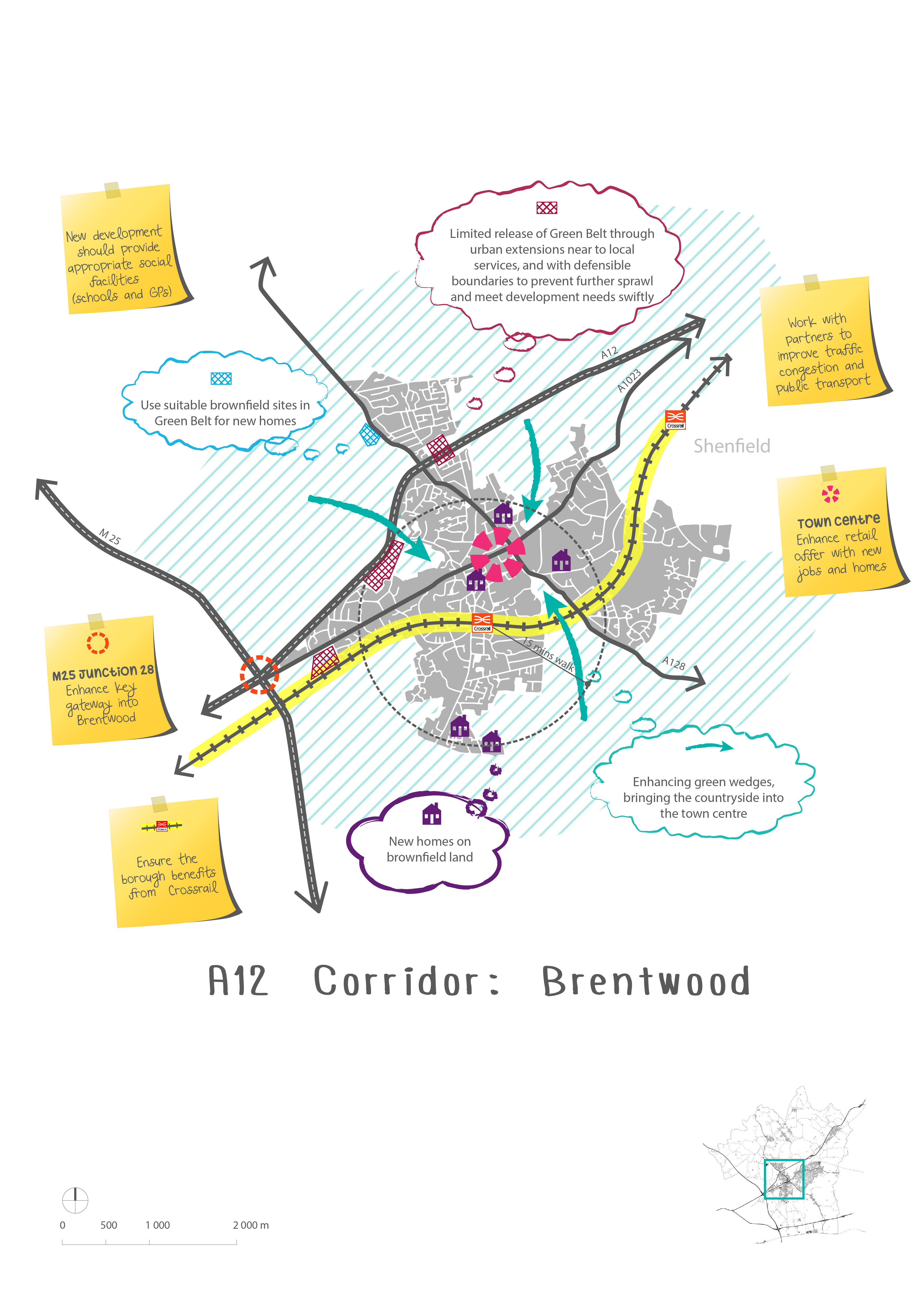
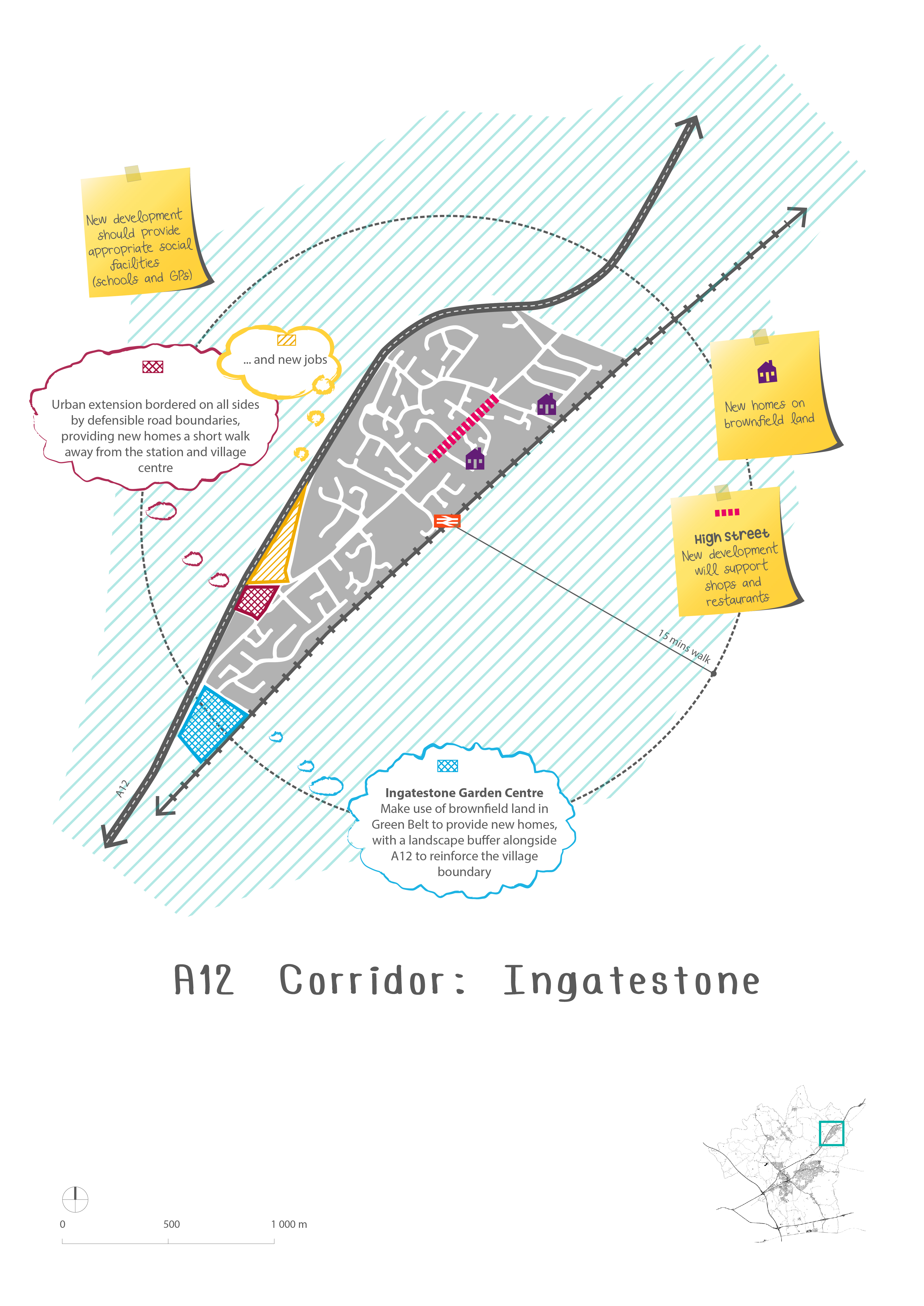
5.19 Within the A12 Corridor, Brentwood and Shenfield are considered sustainable locations for growth, given excellent transport links, access to jobs and services and town centre facilities. Developing in the wider Brentwood Urban Area would support redevelopment and regeneration, underpin the viability of the town centre, and provide opportunities for development where access to services and jobs is greatest. Ingatestone will help to support growth in sustainable locations although capacity constraints and land availability limit development potential. Mountnessing village will be retained as existing with recently permitted development nearby to the village making a significant contribution to the Borough's needs.
5.20 Within the A127 Corridor, a new strategic allocation at Dunton Hills Garden Village will provide a new mixed use self-sustaining community in the south-east of the Borough. A strategic allocation at M25 junction 29 (Brentwood Enterprise Park) will provide for the majority of new employment land needed, bringing forward a modern business park village in the south-west of the Borough with excellent access to the M25. This will also act as a focus for a wider M25/A127 employment cluster considering existing employment uses in the area. Brownfield opportunities will be taken to effectively meet local needs, such as a residentialled mixed use redevelopment of existing industrial land in West Horndon, creating a new village centre with supporting services and facilities close to the village rail station. Developing here provides an opportunity to address conflicts arising from heavy freight passing through the village, strengthen the village centre, and improve service provision. Significant improvements to infrastructure and services will be required to support growth within the A127 Corridor.
5.21 Growth in the Rural North and Rural South areas of the Borough will be limited to retain local character. Brownfield opportunities will be encouraged where appropriate schemes help meet local needs, and in line with other policies in this Plan help ensure our villages remain thriving communities. Where appropriate this includes the redevelopment of previously developed sites in Green Belt and infill while improving links to nearby villages.
5.22 Green Belt currently makes up 89% of the Borough's total area. If proposed development allocations set out in this Draft Plan came forward and were removed from Green Belt this would reduce by 1%. This means development needs can be sustainably met in the Borough whilst Green Belt would still make up 88% of the total area.
5.23 The Draft Plan Key Diagram shows the main aspects of the spatial strategy set within the broader local context. This also includes some key aims of other policies in the Plan. Figures 5.5-5.9 depict the key diagram in more detail, focusing on transport corridors and setting out some of the thought process behind how proposals have been made.
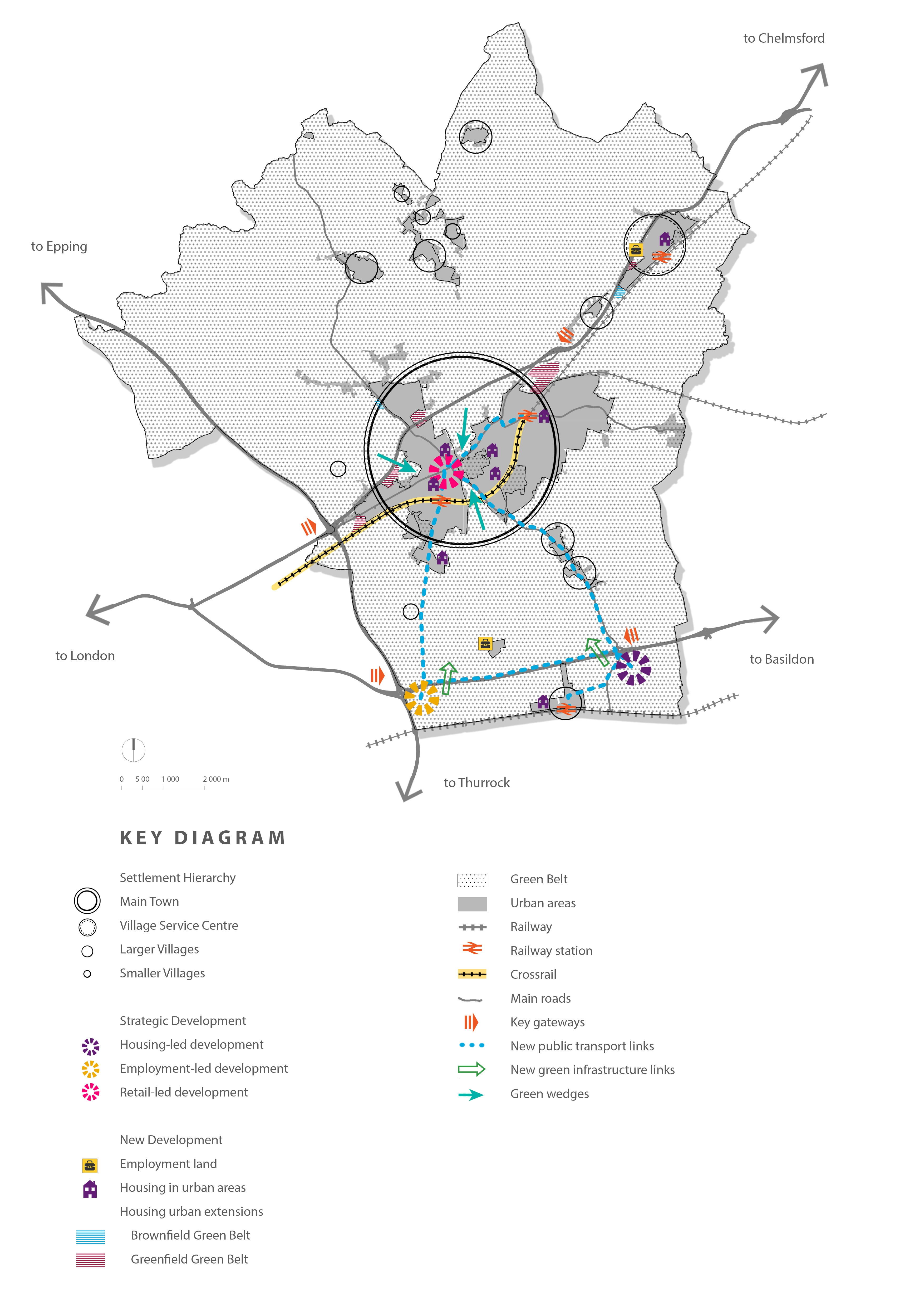
(4) Key Diagram

(1) Figure 5.6

(6) Figure 5.7
(3) Figure 5.8

(33) Figure 5.9
(5) Hierarchy of Place
5.24 Within the Borough a settlement hierarchy can be discerned based on the characteristics of each settlement taking into account services and facilities available. These characteristics help suggest where might be best placed to accommodate growth in a sustainable manner.
(2) Settlement Category 1: Main Town
Brentwood Urban Area, made up of connected local centres such as Brentwood, Shenfield, Hutton, Warley, Brook Street, and Pilgrims Hatch
5.25 Brentwood is the Borough's largest settlement and only town. It includes a wider urban area made up of other connected local centres. Accessible and well served by public transport, with rail stations at Brentwood and Shenfield, the town provides a range of shopping, employment areas, secondary schools, health and leisure facilities in close proximity to residential areas.
5.26 Brentwood Town Centre is the Borough's main focus for shopping, community and leisure activities, supported by shopping facilities around the rail station and other local shopping parades.
5.27 Within this settlement category, Brentwood and Shenfield offer the most scope to develop in accordance with sustainable development principles. Urban extensions into Green Belt are proposed in specific locations with clear physical defensible boundaries and accessible to local services and transport links. Release of land for development in these locations will enable a five year supply of housing to be achieved, boosting local housing needs swiftly in line with national policy and guidance.
(4) Settlement Category 2: Village Service Centres
Ingatestone
Dunton Hills and West Horndon later in the Plan period
5.28 A district shopping centre with a good range of jobs, community and health facilities, Ingatestone currently provides the second category in the hierarchy. As the Borough's largest village, facilities here serve a significant catchment beyond the immediate area. Public transport accessibility is relatively good. The village has a rail station and secondary school.
5.29 While Ingatestone has relatively good facilities, a modest level of development is envisaged here, due to infrastructure constraints and a lack of suitable sites.
5.30 Future development as guided by this Plan will result in changes to the hierarchy. Brownfield residential development at West Horndon is proposed to be of a size to provide for a new village centre along with new retail and job opportunities. This is likely to move West Horndon from category 3 into category 2. In addition, development at Dunton Hills Garden Village will create a new self-sustaining village with provision of new schools alongside retail and health facilities, and so this is likely to result in the new settlement being brought into category 2.
(5) Settlement Category 3: Larger Villages
Includes Blackmore, Doddinghurst, Herongate, Ingrave, Kelvedon Hatch, Mountnessing, and West Horndon
5.31 Larger villages in the Borough are served by a local shopping parade and a primary school. They generally have limited community and health facilities, local jobs and a variable bus service.
5.32 As well as these facilities, West Horndon has a rail station and a large brownfield redevelopment opportunity using the existing employment areas. Among the Borough's villages it offers the most scope for development, although it will be important to retain the settlement as a village and not over-develop in order to be consistent with the proposed spatial strategy.
5.33 Brownfield redevelopment opportunities will be encouraged to meet local needs and policies in this Plan will help to bring forward nearby redevelopment of brownfield sites in the Green Belt where appropriate. No amendment is proposed to the Green Belt boundaries surrounding larger villages in order to retain the character of the Borough in line with the spatial strategy.
(2) Settlement Category 4: Smaller Villages
Includes Fryerning, Great Warley, Hook End, South Weald, and Wyatts Green
5.34 Remote smaller settlements, with poor public transport, limited shops, jobs and community facilities. Development opportunities are limited, although as with larger villages brownfield redevelopment opportunities will be encouraged to meet local needs where appropriate. No amendment is proposed to the Green Belt boundaries surrounding smaller villages. Some of these smaller villages are entirely within Green Belt.
(20) New Homes
5.35 Under the previous planning system local authority housing targets were set by regional spatial strategies. This was the East of England Plan for Brentwood Borough, which sought to balance the demand and sustainable supply of new homes across the whole region. The East of England Plan was abolished in January 2013 leaving local planning authorities to set their own targets. Housing targets should comply with national policy and guidance and be managed within the local housing market area, not necessarily within administrative boundaries.
5.36 The Council's Strategic Housing Market Assessment (SHMA) concludes that Brentwood Borough can be considered a self-contained housing market area and emerging evidence from adjacent authorities show wider surrounding market areas that do not include Brentwood. While the Council accepts there are some links with other neighbouring local authorities on a range of issues to be discussed through the Duty to Cooperate, we have moved forward with a Draft Plan that seeks to fully meet objectively assessed housing needs within the Brentwood Borough boundary.
5.37 In response to the requirements of national policy the Council has made an objective assessment of its housing need in line with planning practice guidance. This technical work concludes that the Borough has a range of housing needs to consider depending on projections and historic delivery rates. The Draft Plan takes an objectively assessed housing need of 362 new dwellings per year as the starting point to meet housing need, more than double the Borough's housing target under the East of England Plan. The Government expects Local Plans to meet objectively assessed needs for market and affordable housing, with sufficient flexibility to adapt to rapid change unless the adverse impacts of doing so would significantly and demonstrably outweigh the benefits.
(162) POLICY 5.2: Housing Growth
Provision is made for 7,240 new residential dwellings (net) to be built in the Borough over the Plan period 2013-2033 at an annual average rate of 362 dwellings per year distributed as follows:
|
Net homes |
% |
|
|
Completions 2013/14 & 2014/15 |
383 |
4% |
|
Extant permissions (April 2015) |
444 |
6% |
|
Permitted development allowance since April 2015 |
300 |
4% |
|
Urban areas (brownfield) |
1,296 |
18% |
|
Brownfield land in Green Belt |
97 |
1% |
|
Strategic Site |
2,500 |
35% |
|
Greenfield urban extensions in Green Belt |
1,292 |
18% |
|
Windfall allowance |
928 |
14% |
|
Total |
7,240 |
100% |
Sites with a capacity for 10 or more dwellings (major housing sites) allocated for residential development are set out in Policy 7.4 and shown on the Proposals Map.
Policy 5.2 contributes towards objectives SO1, SO2, and SO3.
5.38 Policy 5.2 sets how many dwellings the Borough will accommodate over the Plan period. Figures include existing commitments (permissions and allocations) and take account of housing potential on sites identified through the evidence base and previous Local Plan consultations. In addition, other exercises such as a Council asset review and review of other public assets have been undertaken to identify suitable redevelopment options. This work will continue as various public services consider their assets.
5.39 Bringing forward housing growth will deliver a boost to the local economy. The Council and other partners will need to consider the implications that new housing growth will bring, such as social, health, education, amenities, local services and facilities.
5.40 In deciding how many homes the Borough should plan for, the Council has taken into account national policy and evidence on the number and kind of homes needed. It is also vital that the capacity to accommodate new development while maintaining the Borough's distinctive quality and character are balanced in line with the spatial strategy. Availability of supporting services and infrastructure are also key considerations which affect capacity.
5.41 In order to boost significantly the supply of housing in line with national requirements this Plan makes provision for a range of sites. Given housing needs cannot be fully met on brownfield sites and within existing urban areas the Council has reluctantly considered appropriate and sustainable locations within Green Belt. A proportionate approach has been taken, focusing on transport corridors and limited release of Green Belt to meet local needs where clear defensible boundaries are in place to avoid further urban sprawl. This is critical to help strike the right balance between maintaining the Borough's character and meeting development needs in line with strategic objectives and the spatial strategy.
5.42 The starting point for site densities has been the Council's Strategic Housing Land Availability Assessment (SHLAA). The Council has applied densities to potential development sites in a realistic manner taking into account surrounding development and the general form of an area. However, given the large and urgent need for new homes sites in the most sustainable locations will need to provide for higher densities where this is appropriate and taking into account any constraints.
5.43 An allowance has been made for windfall sites given the historic delivery rates of such development that has made a significant contribution to the Borough's housing supply. Windfall can be defined as sites which have not been specifically identified as available in the Local Plan process. These are usually previously developed sites that have unexpectedly become available. Sites less than 10 dwellings are not allocated, although such sites will continue to contribute towards housing supply over the next 15 years.
5.44 In addition, other policies in this Plan that encourage development, where it is deemed appropriate, will allow for an increase in new homes coming forward and so this is measured within a windfall category considering such sites have yet to be identified. The Council is keen not to be reliant on windfall to meet needs, and so continued work will be undertaken to determine realistic site densities for allocated sites to determine the remaining windfall contribution.
5.45 Brentwood's Strategic Housing Market Assessment (SHMA, 2014) identifies a high level of affordable housing need within the Borough which has among the most expensive housing in Essex, comparable to London house prices. However, local wages do not compare well with London and many local workers cannot afford to live here. This makes it harder for business to recruit, increases commuting and worsens transport congestion and quality of life. This Plan seeks to maximise affordable housing provision in light of identified needs.
(5) Housing Trajectory
5.46 Figure 5.10 sets out the expected rate at which new homes will be provided in the Borough over the Plan period. Further detail is given in Appendix 2. The housing trajectory displays the difficulty moving from significantly lower housing delivery up to full objectively assessed needs in a short space of time. The Council has strived to be realistic about the likelihood of sites coming forward and more evidence will be required to prove this moving forward to the next stage of the plan making process. A clear commitment is shown in this Plan to bring forward land as quickly as possible to meet housing needs swiftly in line with national policy and guidance.
5.47 The housing trajectory is made up of various types of sites as set out in Policy 5.2. The following categories are used in line with the proposed spatial strategy and sequential approach to selecting sustainable areas for development.
- Completions since April 2013 = 264 new homes (2013/14 & 2014/15)
- Specialist housing completions since April 2013 = 119 homes (C2 older person units)
- Ensure extant planning permissions are completed in good time to contribute towards five year housing supply = 444 new homes (April 2015)
- Allowance for permissions and permitted development since April 2015 = 300 new homes (April 2015-January 2016), includes Mountnessing Roundabout (85 units, 14/01446/EIA), Thoby Priory (87 units, 15/00527/OUT), and Hubert Road (104 units, prior approval not required, 15/00393/PNJ56)

(3) Urban Areas
- Prioritise brownfield sites wherever suitable and make efficient use of land in urban areas = 1,296 new homes
(5) Brownfield Green Belt (Urban Extensions)
- Previously developed land (brownfield) in Green Belt adjoining urban areas in transport corridors = 97 new homes
(4) Strategic Sites (Green Belt)
- Large site at Dunton Hills Garden Village (see Policy 6.1), making a significant contribution to housing needs and able to provide a selfsustaining community with services and infrastructure = 2,500 new homes
(3) Greenfield Green Belt (Urban Extensions)
- Remaining requirement to ensure housing is delivered as quickly as possible results in consideration of a limited number of greenfield sites in Green Belt to form urban extensions but with clear defensible and physical boundaries (such as roads or railway lines rather than trees or hedgerows) = 1,292 new homes
(4) Windfall
- Windfall allowance for small scale development and development that will come forward in future not identified at this point, in line with proposed policies to effectively and efficiently use land to meet local needs = 928 new homes
(4) New Jobs
5.48 A key measurement of economic growth is the amount of new jobs created. This can be through a variety of business sectors. The Borough has recorded strong levels of job growth over the last 17 years (30%). For the purposes of planning policy the simplest way to measure and plan for new job creation is through planning use classes. B-Class uses generally comprise employment land types, such as B1 Business (offices, research and development, light industry appropriate in a residential area), B2 General industrial, and B8 Storage or distribution.
5.49 The number of B-Class jobs has increased by 40% over the last 17 years. Policies are required to plan for future jobs growth on our employment land and ensure new employment land is provided where needed.
5.50 In addition to B-Class jobs policies in this Plan encourage new jobs in other sectors, such as retail and commercial leisure. The Council will also work with partners to ensure continued inward investment to the Borough and the spatial strategy will maintain qualities that make Brentwood an attractive place to work.
5.51 In the past employment growth in Brentwood has been driven by consumption sectors including residential care and social work, business services, education, healthcare and construction. Job losses have been recorded within public administration and defence, utilities, accommodation and food services and retail.
(24) POLICY 5.3: Job Growth and Employment Land
Provision is made for 5,000 additional jobs to be provided in the Borough over the Plan period at an annual average rate of 250.
Job growth will be distributed primarily through new employment (B-use) allocations but supported by existing employment sites and appropriate redevelopment where appropriate. In addition, other business sectors will support job growth over the Plan period, such as retail, hotel and leisure uses.
Providing for this many jobs will require a total of 32.8 hectares of new employment land. Areas allocated for employment purposes are set out in Policy 8.4 and identified on the Proposals Map.
Policy 5.3 contributes towards objectives SO4 and SO7.
5.52 Policy 5.3 sets out how many new jobs are to be provided in the Borough over the Plan period and how much additional employment land will be allocated to provide these. Reflecting the Borough's desirable location, high quality and distinctive offer and land constraints, the Council's preference is for efficient land use and provision for high value business. With regard to the rural economy, the preferred approach seeks to encourage rural enterprise which benefits local communities while respecting the quality and character of the countryside.
5.53 With the abolition of the East of England Plan, a baseline figure for local job growth is now something that needs to be determined to inform future planning policy. As a result, the Council is required to determine its own locally-derived employment targets. A range of economic evidence has informed this employment land and job growth need, such as the Brentwood Economic Futures report (2014). Proposed job growth is also informed by the Borough's objectively assessed housing need. This is up to 22.75 hectares of new employment land needed.
5.54 Selection of sites for new employment land has been considered through the same sequential approach of land types as has been the case with housing development. The proposed employment strategy is to locate new employment land close to the strategic highway network, taking account of more modern transport needs for larger heavy goods vehicle movements compared to some sites built years ago in central areas.
5.55 Brownfield land at M25 junction 29 provides an opportunity to redevelop the site and meet the majority of employment need, including the potential to re-use displaced older employment premises suitable for housing-led redevelopment in central areas. Brentwood Enterprise Park (see Policy 8.2) will provide an opportunity for high-end modern premises at a key gateway to the Borough and into Essex.
5.56 Redeveloping existing employment land in central or residential locations for new homes (i.e: Wates Way Industrial Estate, Brentwood; Council Depot, Warley; and West Horndon Industrial Estates), means the loss of almost 19 hectares of employment land that will need to be re-provided. Incorporating the replacement of these losses in their entirety on a like-for-like basis would increase future employment land requirements up to 41.65 hectares in total. The exact types and quantity of floorspace that could be lost and/or displaced will need to be determined. However, it may not be necessary to fully replace these losses due to changing business needs and efficiency gains associated from replacing older stock with modern space. It is also not clear if employment needs will be lost entirely on these sites as part of redevelopment. Further work will need to be undertaken to identify exact loss of employment and the extent to which this needs to be replaced.
5.57 In addition to this, small amounts of new employment land are proposed to be allocated as part of an extension to an existing employment site at Childerditch and as part of development of a site bordered by roads (including an A12 junction) in Ingatestone. Development at Dunton Hills Garden Village will also provide for an element of new employment land in a location to be decided. These sites will provide choice for new employment land located on the strategic highway network in line with the proposed spatial strategy.
5.58 It is also proposed that some existing employment sites not formally allocated as such (and therefore still within Green Belt) be formally allocated. In particular, this focuses on a cluster of new and existing employment premises near to M25 junction 29 and the A127, as depicted in Figure 5.12.

(3) Figure 5.12: M25 Junction 29 Employment Cluster
5.59 Major employment sites contributing to the Borough's job growth over the Plan period are identified on the Proposals Map and listed in Policy 8.4. Details of strategic development at Brentwood Enterprise Park and Dunton Hills Garden Village can be found in Policies 8.2 and 6.1 respectively.
5.60 Overall a total of 48.2ha of new employment land is proposed to be allocated. Excluding new allocations with existing employment uses on site (15.39ha) this totals 32.81ha. In addition to these sites there are also existing employment allocations from the 2005 Brentwood Replacement Local Plan.
5.61 Economic evidence informs the amount of land the Council needs to provide to achieve sufficient growth in jobs. This calculation is summarised in Figure 5.13, which gives a breakdown of new B-use employment land required to inform Draft Plan allocations. It should be noted that suggested employment allocations exceed requirements. This calculation is explained below:
- The amount of additional employment land needed over the Plan period is taken from the Brentwood Economic Futures report (2014) and uses the highest range figure = 22.75ha
- The total amount of existing employment land lost to preferred housing allocations is taken from three sites to be allocated for housing/mixed use = 18.9ha
- Existing employment land available for development is made up of unused employment allocations from the Brentwood Replacement Local Plan (2005) and extant planning permissions for employment land at April 2013. Net available employment land is 5.56ha (2.69ha extant planning permissions and 2.87ha extant allocations). Taking away unused employment land at the Council Depot in Warley ((draft housing allocation 081) 0.65ha of unused land) this reduces the total available land to 4.91ha
- These elements combined result in a total additional employment land requirement of 36.74ha

(4) New Retail and Commercial Leisure
5.62 The Council is required to positively promote competitive town centre environments and manage their growth. It is important to develop a town centre strategy that is appropriate and realistic to the role of centres in both the Borough's settlement hierarchy and shopping hierarchy. These should be based on the current state of centres and opportunities to meet development needs in full. In this regard, meeting retail needs and planning for the future of town and district centres are intrinsically linked. The Council is preparing a Brentwood Town Centre Masterplan to consider these issues in more detail, which is explored further under Policy 8.6.
5.63 When it comes to meeting retail and commercial leisure needs it is important to consider the Borough's shopping hierarchy, which can be viewed in full at Appendix 1. Brentwood Town Centre is the main shopping centre in the Borough. Shenfield, Ingatestone and Warley Hill function as district centres. The Borough also contains a number of smaller villages and local shopping parades.
5.64 Brentwood Town Centre is categorised as a sub-regional centre and falls within the catchment areas of much larger competing centres at Chelmsford, Basildon and Romford. In addition, Lakeside, Bluewater, Stratford City and Central London are all easily accessible to residents. The strength of this competition restricts the Borough's market share of expenditure, particularly for comparison goods. However, the Town Centre has a good amount of convenience and comparison retail, with above average comparison operators. There is a mix of larger retail brands and a growing number of independent traders. The proportion of comparison goods operators is above the national average, and the centre has a good provision and range of comparison categories. The main convenience offer is from the large Sainsbury's supermarket, which suffers from congestion at busy periods but provides many linked trips to High Street shops.
5.65 Shenfield and Warley Hill are located within the Brentwood urban area and provide a more local service to residents. Ingatestone is a more traditional village centre and serves its settlement and the rural catchment area, providing a range of shops and non-retail services. The comparison shopping offer of these centres is focused on lower order day to day products. Food and grocery shopping is a key element of these centre's overall attraction.
5.66 Retail needs are traditionally split into two categories; convenience goods and comparison goods. More recently the proportion of restaurants and cafes has also increased in High Streets.
- Comparison Goods: Often products from High Street shops clustered together, purchased relatively infrequently by consumers and so prices, features and quality levels are often compared before purchasing. Examples include clothing and appliance stores.
- Convenience Goods: Often products of habit or impulse, easily found by consumers and inexpensive enough for most to purchase. A prime example is goods sold in foodstores.
(8) POLICY 5.4: Retail and Commercial Leisure Growth
Provision is made for 4,844 square metres (net) of comparison retail floorspace and 3,833 square metres (net) of convenience floorspace to be provided in the Borough over the Plan period.
The primary location for new retail growth will be Brentwood Town Centre. New local retail provision will also accompany mixed-use development at Dunton Hills and West Horndon.
Policy 5.4 contributes towards objectives SO5, SO7, and SO13.
5.67 Policy 5.4 sets out the amount of new retail floorspace to be provided in the Borough over the Plan period according to whether it is for comparison or convenience goods. As well as improving the shopping offer to local communities growth in retail and commercial leisure will make a significant contribution towards job growth in the Borough.
5.68 Short to medium term capacity figures up to 2020 suggest surplus of available convenience goods expenditure could support an additional 2,151 sq.m net (3,074 sq.m gross), primarily concentrated in Brentwood Town Centre. In the long term, surplus expenditure at 2030 could support 3,833 sq.m net of sales floorspace (5,475 sq.m gross) in the Borough as a whole.
5.69 For comparison goods the surplus expenditure could support an additional 1,193 sq.m net (1,591 sq.m gross) by 2020 across the Borough. The surplus expenditure at 2030 could support 4,844 sq.m net (6,458 sq.m gross). The vast majority of this surplus is for Brentwood Town Centre, with only a very limited amount identified for the rest of the Borough.
5.70 There is also requirement for 2,954 sq.m gross of food and drink (A3- A5) floorspace and 1,654 sq.m gross of other class A1 service uses up to 2030. No specific provision is made for these uses as these needs can be met through the planning application process in line with other policies in the Plan.
5.71 The spatial strategy focuses retail-led mixed use development in Brentwood Town Centre, in line with the sequential approach required by national policy. The opportunity for redevelopment of the William Hunter Way car park site could absorb a significant proportion of the retail floorspace requirements for the town centre. The Baytree Centre also provides a further development opportunity within the town centre. Both sites are considered to be'strategic' within the Draft Plan because of their ability to provide for significant retail-led mixed use development in a sustainable location (see policies 6.6 and 8.6). These sites and their relationship with the High Street will also be considered further as part of a design-led Masterplan for the Town Centre.
5.72 There is a limited requirement for further floorspace within Shenfield, Ingatestone and Warley Hill over the Plan period. The commercial leisure assessment concludes that a cinema would be desirable to meet the needs of local residents. There is limited potential for other large scale commercial leisure facilities over the Plan period.
5.73 National policy principles indicate that the policy approach should aim to at least fully meet retail needs, so that the local economy is not constrained and potential investment is not diverted elsewhere or lost. The sequential approach suggests that designated town centres should be the first choice for retail, leisure and main town centre uses. All development should be appropriate in terms of scale and nature to the centre in which it is located.
5.74 Given the existing low levels of vacant floorspace within the centres, it is unrealistic to plan to achieve a reduction in vacancy rates, and the reoccupation of vacant premises is unlikely to help accommodate growth.
5.75 Strategic Town Centre sites also provide opportunities to improve public realm connections with the High Street. This could incorporate restaurant/cafe uses to create more of a destination shopping experience. Opportunities to improve the area around the Chapel ruins will help create a new 'town square' and encourage linked trips. This will provide new and attractive public space while making more of the Chapel ruins and protecting this ancient monument.
5.76 An axonometric diagram is provided in Figure 5.14 to display the context of Brentwood Town Centre, strategic sites and opportunities for improved links. Other sites can provide additional retail floor space as part of redevelopment, such as the former Wates Way Industrial Estate (Ref 003).
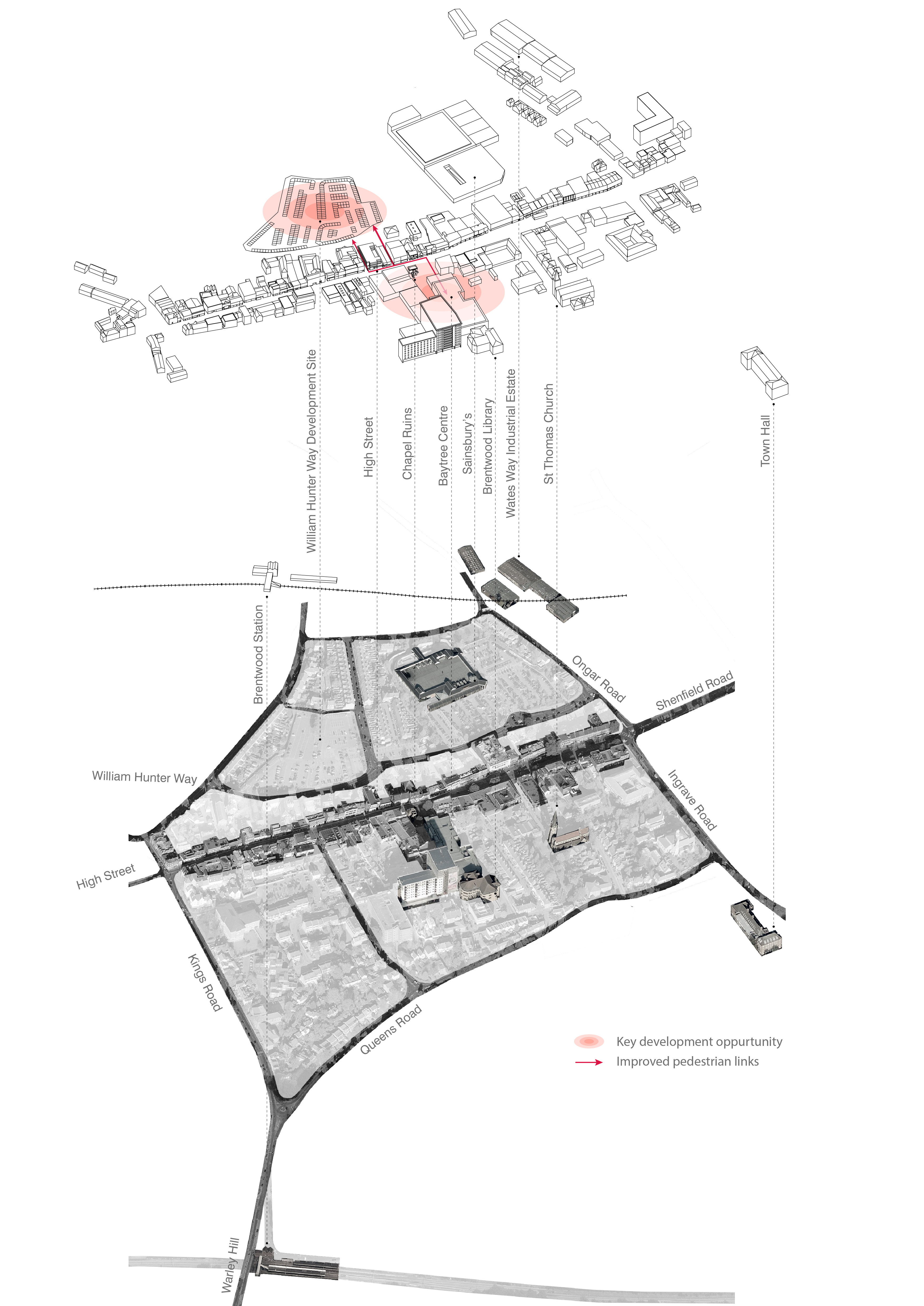
(2) Figure 5.14: Brentwood Axonometric Diagram
5.77 As available sites in Brentwood cannot accommodate full retail floorspace needs, residential-led allocations creating new and improved village centres at Dunton Hills and West Horndon will provide for the Borough's remaining local retail needs. New retail floorspace will serve the local community. Residential-led mixed use development at West Horndon will provide the opportunity to create an improved village centre near to the railway station. This will include new retail floorspace to serve the village and local area. This will need to complement rather than compete directly with the existing local shops.
5.78 Development options for additional retail floorspace are limited in Shenfield, Ingatestone and Warley Hill. The strategy for these centres focuses on the reoccupation of vacant units and small scale intensification and extensions.
5.79 The increased number of passengers travelling through and using Crossrail stations at Shenfield and Brentwood (Warley Hill district centre) could lead to demand for additional or improved retail and service facilities over and above the identified floorspace requirements. There are limited short term opportunities for additional development in the vicinity of these stations, but in the longer term, sites could become available to meet anticipated future needs. In line with other policies in the Plan, such as maximising opportunities to meet development needs around key gateways, specifically rail stations, retail needs will be prioritised as part of mixed-use development.
5.80 Other local centres in the Borough will continue to play their vital role in providing day to day shops and services that are accessible to residents in villages and rural parts of the Borough.