Schedule of Potential Main Modifications
Chapter 3
(152) MM2
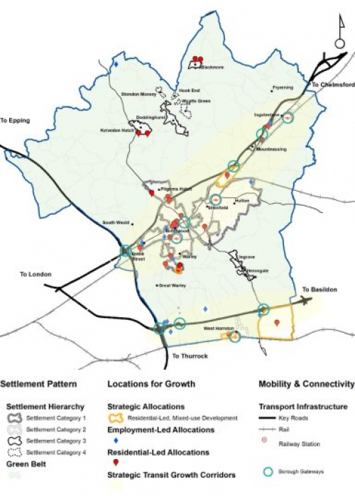
Page Number 36-40, Paragraph 3.1 - 3.26, Figure 3.1, Figure 3.2, Figure 3.3
Modification
Delete paragraphs 3.1-3.9 and add new paragraph:
Spatial Strategy Driving Factors
3.1 The vision for the development of the borough reflects and capitalises on Brentwood's qualities (i.e. village character, heritage, environment), needs (i.e. liveable places, thriving enterprises), and opportunities (i.e. new economic opportunities, connectivity, thriving high streets for entertainment and culture).
The vision is reinforced by strategic aims and four strategic objectives and related policies.
Amend paragraphs 3.10 to 3.22 to read:
Strategic Aims and Objectives
Spatial Strategy Overarching Aims
3.10 Driven by Brentwood's Borough of Villages character, our spatial strategy focuses on three main overarching driving forces aims are to: a) harness the connectivity opportunities offered by the borough's accessible transit corridors; b) orientate proposals to consider and embed a 'design and build with nature' landscape-led approach; and c) ensure that proposals demonstrate how outcomes will deliver healthy communities on multiple levels.
Promoting Sustainable Mobility through Transit-orientated Growth
3.11 A key aim is ensuring sustainable mobility is maximised given the borough's rural setting. Sustainable mobility is key in achieving a healthier environment, particularly in reducing air pollution from vehicular travel, but also in providing the necessary connectivity network to aid the local economy. Brentwood has two key transit / connectivity corridors running through the borough and these are identified in this Plan as the broad locations for growth to maximise these sustainable mobility opportunities: 'Central Brentwood Growth Corridor', with the A12, the Great Eastern Main Line to London Liverpool Street Station, and the Elizabeth Line; and the 'Southern Brentwood Growth Corridor', with the A127 and the London, Tilbury and Southend Railway to London Fenchurch Street Station. These form key connectivity axes. Focusing growth along these axes will ensures that future development is sustainable, maximising the benefits of transport infrastructure. While some investment to improve the transport network is necessary will be inevitable, this growth strategy ensures economies of scale are reached, with the critical mass of development making it more viable for such investment to occur.
DEVELOPING NATURALLY AND SUSTAINABLY
3.12 Given Brentwood's village feel and countryside setting, development must be mindful of the ecological sensitivity and disruption to ecosystem services. For this reason, development should take a 'design and build with nature' landscape-led approach to drive design quality and create places which respond to their existing environment, work with natural assets, and create Environmental Net Gain wherever possible. Opportunities to embed green infrastructure in the public realm should be maximised to deliver multiple benefits, including ecosystem services to address the impacts of climate change as well as providing a liveable environment. This will not only plan for resilient and smart infrastructure to future-proof investment against climate change but also create living environments conducive to human health.
HEALTHY COMMUNITIES
3.13 Growing from a market town to the diverse economy it is today, future development should capitalise on this evolution to ensure a diverse balance of employment opportunities for all alongside vibrant hubs of economic and social-cultural activity to provide attractive, resilient, connected, walkable, lively and stimulating destinations with the necessary facilities and services required to sustain healthy and active communities.
3.14 These goals are supported by four strategic objectives and respective policies, as illustrated in Figure 1.1.
Strategic Objectives
3.15 This section defines our four strategic objectives which consolidate the Borough's key priorities and help make the link between the vision and. and how the supporting policies align which to help to deliver these. In reality there are many cross-overs between each objective and the policies which help delivery these, and should therefore not be treated in isolation when developing proposals.
3.16 SO1: Manage Growth Sustainably, by directing development to the most sustainable locations along identified transit growth corridors, ensuring that the characteristics and patterns of our different settlements are protected and enhanced to provide a strong emphasis on 'sense of place', to be enjoyed by people living, working and visiting Brentwood.
3.17 SO2: Deliver a Healthy and Resilient Built Environment, one where our a landscape-led design approach helps to protect and enhance areas of environmental and heritage value and creates spaces that encourage social interaction, sustainable connectivity and mobility and healthy active lifestyles; mitigates, reduces impact or adapts to conditions of a changing climate through smart infrastructure; creates public realm and homes where both the internal and external spaces are conducive to human health.
3.18 SO3: Deliver Sustainable Communities with Diverse Economic & Social-cultural Opportunities for All, opportunities which flexibly respond to the changing economic climate and employment sector trends making citizens feel economically empowered to enjoy and benefit from the necessary community/social infrastructure that sustains inclusive, informed, vibrant, active and cohesive communities.
3.19 Deliver Beautiful, Biodiverse, Clean and a Functional Natural Environment, where resources are carefully managed to avoid adverse impact on, and to provide net gains for, the borough's natural environment and biodiversity; and whereour natural heritage is protected, and ecosystem services are restored, enhanced and integrated back into the built environment through multi-functional green and blue infrastructure and opportunities are pursued for securing measurable net gains for biodiversity.
Delete paragraph 3.20
Spatial Strategy - Growth Areas
3.21 Two key growth corridors areas have been identified, considering to meet our overarching aim to deliver sustainable development in accessible and connected transit corridors. Along these corridors, a comprehensive through a process of sequential analysis and review of sites has been undertaken to select suitable site allocations.
Central Brentwood Growth Corridor
a In the The Central Brentwood Growth Corridor, runs through the main urban area of Brentwood (incorporating the neighbourhoods and towns of Brentwood, Shenfield, Hutton, Warley, Pilgrims Hatch) as well as the urban area of Mountnessing and Ingatestone villages further along the A12 corridor. The main central urban area is well served by public transport, with rail stations at Brentwood and Shenfield. It provides a range of shopping, employment areas, secondary schools, health and leisure facilities in close proximity to residential areas. It therefore offers scope to accommodate some growth.
Here,we will maximise every opportunity to bring forward brownfield land for development has been maximised and brownfield regeneration will continue to be prioritised as and when it becomes available in future., where appropriate, in Brentwood and Shenfield. This will take account of the arrival of the Elizabeth Line, and reflect our commitment to deliver brownfield development, in consistency with the NPPF (2018). However, brownfield land is limited and so the spatial strategy in this growth area has also focused on delivering ; and given the opportunity for new development to invest in infrastructure and facilities, we will grow the wider Brentwood Urban Area by providing urban extensions of varying extents, including at Shenfield, Warley, Pilgrims Hatch and Ingatestone. in places, and where Green Belt harm is minimized. This is in response to local housing needs and limited brownfield capacity, providing e Exceptional circumstances have been demonstrated to release to consider limited use of land from the Green Belt to allow these urban extensions.In addition, opportunities to grow Ingatestone Village will be taken where contained sites can deliver an urban extension to the south, providing new housing and supporting employment.
South Brentwood Growth Corridor
b.In the The South Brentwood Growth Corridor runs along the southern transit axes up to the borough boundary. This location has traditionally played an instrumental role in delivering the borough's economic growth, with the location of employment sites due to the good transport connections to wider markets. The spatial strategy continues to enhance employment land in this location, and delivers we will deliver two strategic allocations, one brownfield allocation at West Horndon Village and a new settlement at Dunton Hills Garden Village, providing new residential-led, mixed-use development.
A strategic employment allocation at M25 junction 29 (Brentwood Enterprise Park) will provide for most of the new employment land needed, bringing forward a modern business park village in the south-west of the borough with excellent access to the M25. This will also act as a focus for a wider M25/A127 employment cluster considering existing employment uses in the area.
Brownfield development opportunities will be taken to effectively meet local needs, such as a residential-led, mixed-use redevelopment of existing industrial land in West Horndon, will create ing a new village centre with supporting services and facilities close to the village rail station. Developing here provides an opportunity to address conflicts arising from heavy freight traffic passing through the village. Residential-led development in the area will help strengthen the village centre and improve service provision. Significant improvements to infrastructure and services will be required to support growth within the Corridor.
The new Garden Village will be in keeping with the Borough's character as a 'Borough of Villages' and is of sufficient scale to provide the necessary infrastructure to support a self-sustaining community in the south-east of the borough. The Garden Village will be in line with the Government's prospectus for garden communities, delivering the necessary quality and a significant contribution to meeting housing needs. It also provides an opportunity to contribute to the wider infrastructure investment requirements to support long-term growth within this Southern Growth Corridor, along with some capacity for future growth beyond the plan period to meet the evolving housing and economic needs of Brentwood. Exceptional circumstances have beendemonstrated torelease Green Belt to allow a new settlement in this location.
Development Outside Growth Corridors
c. Development in areas outside these growth areas corridors is limited, to retain the local character, with allocations at Kelvedon Hatch and Blackmore villages. Brownfield opportunities will be encouraged where appropriate schemes help meet local needs and ensure that our villages remain thriving communities, in line with policies in this Plan. Where appropriate, this includes the redevelopment of previously developed sites in Green Belt, infill while improving links to nearby villages.
The spatial strategy is set out in Strategic Policy MG01 Spatial Strategy.
Key Diagram
3.22 The Key Diagram shows the main aspects of the spatial strategy, illustrating the broad locations and pattern of development and how these relate to the two main transit growth corridors and borough gateways. set within the broader local context. This also includes some key aims of other policies in the Plan.
Merge figures 3.2 and 3.3 into 3.1 (the Key Diagram) to include the growth areas and gateways.
Remove reference to 'Green Wedge' from Figure 3.1 Key Diagram and update as below:
Delete paragraphs 3.23 to 3.26
Reason
To communicate how the vision, aims, objectives and policies have been positively prepared to deliver the borough's needs and aspirations
Key diagram indicates broad locations for development which is consistent with national policy