Ingatestone & Fryerning Neighbourhood Plan Regulation 16
VISION AND OBJECTIVES
The following economy related objectives form part of the vision statement for the IFNP:
- Supporting measured, proportionate, timely and sustainable development to meet local requirements, particularly those of our young people and older residents.
- Promote a flourishing local economy with a range of successful independent businesses.
- As an existing commuter village, Ingatestone will increase its local employment base with the aim of reducing its export of people.
- The growing population of the parish will be supported with employment sites, appropriate retail outlets and a thriving economy.
- The parish will have the transport connections, available space, facilities and infrastructure to support new and expanding businesses as and when the need arises and the parish council will be active in searching out opportunities for bringing new employment to Ingatestone and Fryerning.
The following economy related aims have been identified by NPAC to guide the production of the IFNP economic policies:
- Preserve and grow the High Street (Figure 10) with predominantly thriving independent shops.
- Encourage business, especially those that can employ local people and are in growth sectors such as technology, creative arts, healthcare, renewable energy, professional education and tourism.
- Maintain and grow the key local economic drivers within the parish.
CONTEXT
Economic Statistics
The Rural Community Profile for Ingatestone and Fryerning[15] identified the following key statistics[16] associated with the economy of the parish.
- There are 2,271 economically active residents in the parish, including 1,252 people employed on a full-time basis.
- The proportion of economically inactive residents in the parish is higher than the national average. This may relate to the higher age demographic in the area.
- There are 421 self employed residents in the parish. This represents a higher proportion of the population than the national average.
- 165 people work from home in the parish. This is also a higher proportion of the population than the national average.
- The parish has a lower proportion of residents claiming jobseekers allowance in comparison to the national average.
- There is a higher than national average proportion of residents in the parish with degree level qualifications.
- The largest employment sectors in the parish are financial and insurance, retail and education.
- There is a higher than national average proportion of residents in the parish employed in managerial, professional or administrative roles.
- There is a lower than national average proportion of residents in the parish employed in skilled and elementary[17] occupations.
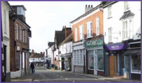
Figure 10: High Street
The local economy
The parish contains two key transport routes which act as key economic drivers for the area. The A12 runs along the western and northern edge of Ingatestone and the slip road in the south of the parish provide good access to the wider highways network.
On the south eastern edge of Ingatestone is the Great Eastern Main Line providing regular service to London, Chelmsford and beyond. Ingatestone is serviced by a station, making the village an important location for commuters to use local businesses, services and facilities, before travelling to work or going home. The quality of the transport connections within the parish encourage businesses to locate in the area and also makes the area a more attractive location for tourists.
There are 215 operating businesses in the parish, predominantly located within Ingatestone. To inform the production of the Neighbourhood Plan, in summer 2018 a business questionnaire was published which sought to identify priorities and issues for local businesses in the area. The majority of respondents to the survey were from businesses on or near the High Street in Ingatestone, which therefore included a large proportion of wholesale and retail related businesses. The questionnaire identified the following key issues for the area:
A high proportion of local employees live more than five miles from their place of work.
- 75% of local employees use a car to get to work.
- Over half of respondents believe that theft through burglary/shoplifting is a current problem in the parish.
- There is a need for more local events, markets and schemes to encourage passing trade and new business to the High Street.
- Transport and parking were cited as the biggest issues for the recruitment and retention of staff in the area (67%), followed by issues with finding the right skills (40%), wage competition (33%) and shortage of affordable housing for employees in the local area (29%).
- The most significant infrastructure challenges for local businesses in the area were identified as mobile coverage (75%), parking (63%) and trade waste (43%).
- 60% of respondents plan to stay within the parish over the next five to 15 years.
- New retail space was identified as the most required type of new business premises in the parish.
- Businesses in the area would like more parking to be made available, preferably free parking, better mobile/broadband provision and more parish council support to encourage local shopping and support small businesses.
The extent of people working on or near the High Street travelling to work by car highlights the need to consider further parking arrangements within the centre of Ingatestone and particularly parking for local businesses, as well as exploring how these employees might be encouraged to travel sustainably.
The parish council is awaiting the outcome of a parking safety audit being undertaken by Essex County Council (ECC) to consider a future approach to improve parking arrangements in the central area of Ingatestone. Through discussions with ECC and developers associated with sites allocated in this Plan, the parish council will seek opportunities to provide additional car parking to service the central area of the parish.
Retail on Ingatestone High Street
The Brentwood Local Development Plan (LDP) Policy PC08, retail hierarchy of designated centres, identifies Ingatestone as a District Shopping Centre where Brentwood BBC would support "localised retail, commercial, flexible workspace, community facilities and services that reduce the need to travel and contribute towards more sustainable and neighbourhood-scale living".
To retain the retail offer and the provision of community services and facilities considered appropriate within the District Shopping Centre, LDP Policy PC10, Mixed Use Development Centres, seeks to retain the use of retail premises and associated uses in Ingatestone High Street for purposes appropriate for a District Shopping Centre. The LDP outlines the appropriate uses for Ingatestone High Street.
The majority of retail premises in the parish are located on Ingatestone High Street and the active shop frontages along the High Street are important to the character of this area as the centre of the village. To protect and support existing retail premises on the High Street and to maintain the function and character of this area, sections of Ingatestone High Street identified in Map 3 have been allocated as 'Primary Retail Frontage Areas'. New development within the Primary Retail Frontage Areas should support and enhance retail and associated uses within the area, providing active frontages at ground floor level which respond to character of the area as the centre of the village.
The parish council will support the following uses at ground level within the Primary Retail Frontage Areas along Ingatestone High Street:
- Shops (E(a)).
- Financial and professional services (E(c)). Cafés and restaurants (E(b)).
- Drinking establishments (A4 uses). Takeaways (A5 uses).
- Hotels (C1).
- Non-residential institutions such as healthcare, nurseries, schools, libraries and places of worship (D1 uses).
- Certain sui generis uses typically found in centres, including theatres, nightclubs, amusement arcades, launderettes, tattooists, beauty parlours.
A greater range of uses will be appropriate at first floor level within the Primary Retail Frontage Areas, provided that the above uses do not inhibit the use of the ground floor for the uses listed above. The ground floor change of use of premises within the Primary Retail Frontage Areas from the uses listed above will not be supported by the parish council unless the applicant can provide compelling evidence and justification that the existing use is no longer viable. This must include evidence that the site has been appropriately and effectively marketed over a sustained period of time (a minimum of 12 months) at a rate which is compared to local market value for its existing use, or as a redevelopment opportunity for other similar uses, together with evidence of the level of interest in the site during the marketing period.
As a direct result of engagement with local businesses the parish council has recently overseen, or is currently in the process of developing, a range of improvements to support businesses on or near Ingatestone High Street, including:
- The repositioning of mobile phone antennae to improve mobile signal.
- Improvements to CCTV to provide increased surveillance coverage and improved safety.
- Seeking to appoint two Community Police Officers.
- Developing a business support network.
The business questionnaire has revealed overwhelming support for retaining Ingatestone High Street as a vital and active retail area. The parish council is keen to support businesses on or near Ingatestone High Street and is seeking to develop projects which will:
- Increase footfall.
- Improve travel into the High Street area.
- Provide additional parking for businesses employees and customers.
- Provide training for retailers.
- Provide growth and development support to local businesses.
- Create events or attractions to encourage visitors to Ingatestone as a tourist destination.
- Providing community WiFi or 5G along Ingatestone High Street.
The parish council is an active participant of the Brentwood Business Partnership (BBP)[18] and is included in developing activities aimed at increasing local trade, such as the annual Easter Egg Hunt for children looking for egg pictures in shop windows, an art trail and the Summer Hunt searching for emblems associated with summer.
Protecting existing employment uses in the parish in order to maintain and improve the status of the area as a thriving economic centre, the parish council will seek to protect existing employment land in the area. Through IFPC Economy Policy 4, the parish council is seeking to expand the provision of employment and safeguard existing employment land within the parish. Proposals which seek to change the use of an existing employment site (class B1, B2, B8 or sui generis use of an employment nature) at a rate which is comparable to the local market value for its existing use, or as a redevelopment opportunity for other similar uses, together with evidence of the level of interest in the site during the marketing period.
The future economy of the parish
Tourism has been identified as an opportunity to increase retail trade on Ingatestone High Street. Ingatestone has an interesting character, a good range of retail premises, cafés, bars and restaurants, good links to the surrounding countryside, Ingatestone Hall and many historic buildings, good accessibility by public transport and from the wider highway network and is in close proximity to large centres of population in Chelmsford and London. Through the establishment of additional events and attractions in the parish, tourism through local and regionally based day visitors could provide an additional boost to the local economy.
As an additional attraction for the area, funding has been received for the completion of the Ingatestone Museum (Figure 11). Greater Anglia are in the process of restoring the building adjacent to the level crossing on Station Lane, through a combination of funding from Greater Anglia and the Railway Heritage Society, to provide the building for use as the Ingatestone Museum. The project will be managed by a charitable trust and restoration work is expected to be completed in 2020. Alongside the museum, the parish council intends to improve signage throughout the villages to improve the overall experience for visitors.
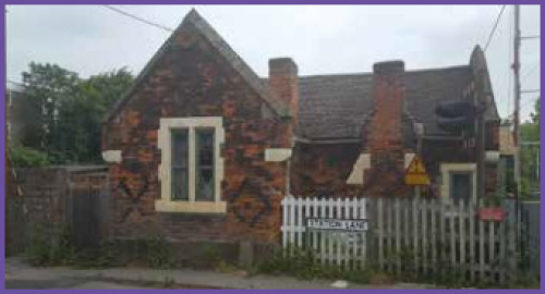
Figure 11: Museum site
Demographic census information[19] of the parish demonstrates that there is a high proportion of people aged 65 and over in the parish and this trend is likely to continue in the future.
Employment within the older age care and healthcare sectors within the parish is therefore likely to increase in the future. The Neighbourhood Plan will seek to encourage more employment opportunities within the parish to encourage economically active people to the area, to create a sustainable balance of older and younger people living and working within the parish.Subject to compliance with other policies in this plan, the parish council will be supportive of development proposals which increase employment opportunities in the local area and support the local economy. Based on the high proportion of residents educated to degree level and beyond, the high proportion of managerial and professional workers in the area and the small scale nature of business which would be likely to locate within the parish, the parish council will encourage new business development proposals associated with growth sectors such as advanced technologies, creative arts, education, renewable energy and low carbon, health and care sectors and tourism.
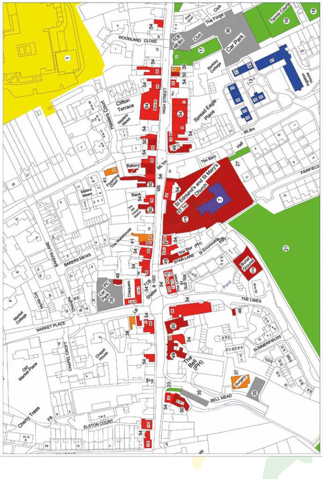
Map 3: High Street Map. Copyright Phill Poston/Elaine Jeater 2019.
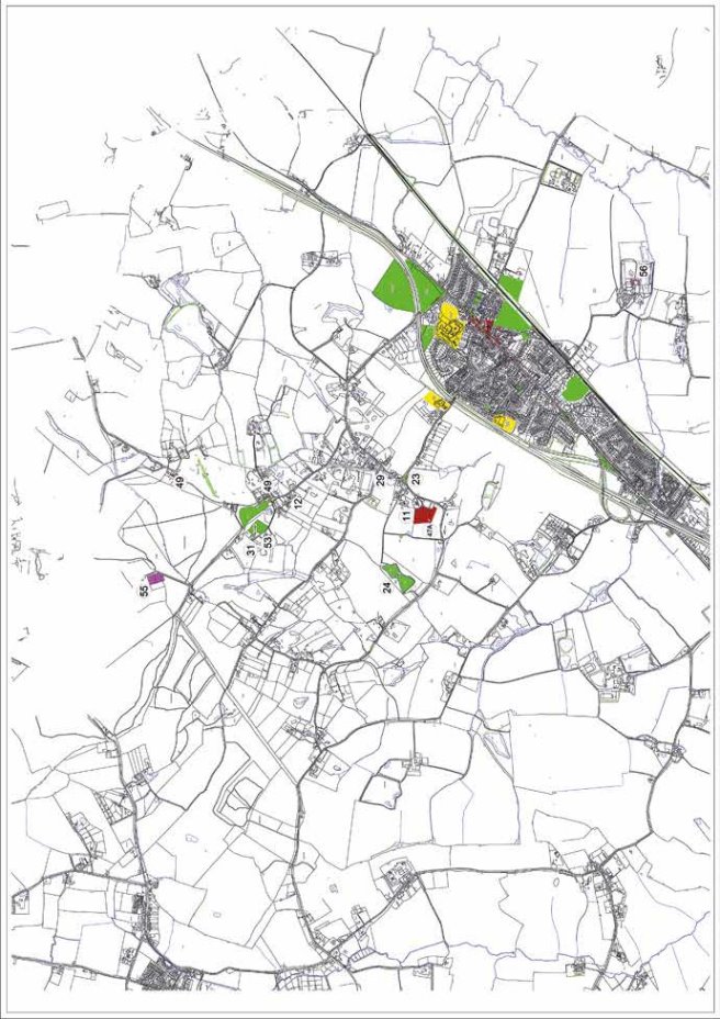
Map 4: Parish Map. Copyright Phill Poston/Elaine Jeater 2019.

Map 5: Village Map. Copyright Phill Poston/Elaine Jeater 2019.
KEY TO COMMUNITY ASSETS MAP (Maps 3, 4 and 5)
COLOUR AMENITY/ NUMBER IDENTIFICATION ASSET
Yellow - Education
1 Anglo European School
2 Ingatestone Infant School
3 Ingatestone and Fryerning C of E (voluntary aided) Junior School
4 Wright Start Day Nursery
5 Roman Road Pre-school URUS playgroup
6 EMU under 5's club
Purple - Religious establishments
7 St Edmund and St Mary Church of England Parish Church, Ingatestone
8 United Reformed Church
9 Elim Church
10 St John the Evangelist and St Erconwald Catholic Church
11 St Mary the Virgin Church of England Parish Church, Fryerning
12 Mill Green Gospel Chapel
Blue - Specialist Housing
13 Brentwood Borough Council sheltered accommodation
14 Essex CC Young person assisted living
15 The Almshouses
16 Ardtully nursing residence
Green - Community recreational land and buildings
17 Ingatestone Community Club
18 Ingatestone Tennis Club
19 Ingatestone Bowls Club
20 Seymour Field and Pavilion (BBC owned)
21 Fairfield Cricket ground and children's play areas (leased by Parish Council)
22 Anglo European playing fields
23 Amenity greens, roundabouts (BBC)
24 Fishing lakes + ponds
25 Ingatestone Boys' Own Club
26 Christy Hall
27 C of E Church parish rooms Ingatestone
28 URC hall
29 Parish Rooms Fryerning (Community Club)
30 Copse
31 Mill Green common
32 Allotments
Grey - Parking and underpasses
33 Underpasses
34 Railway car park (private)
35 Public car park
36 Private car park (Community Club)
Orange - Healthcare
37 Doctors' surgery
38 Private dentist
39 Optician
40 Veterinary surgeon
41 Pharmacist/chemist
42 Chiropodist
Brown - Services
43 Library
44 Post Office and sorting office
45 Railway Station
46 Parish Council Offices
47 A Parish cemetery (Parish Council) - open
48 Public toilets
49 Public houses
50 Restaurants
51 Cafes
52 Fire Station
Black Stripe - Area of Special Scientific Interest
53 Mill Green Common
Red - Shops
54 Shops
47 B Closed burial grounds
Pink - Historical:
Scheduled monument - 55 Roman villa (near Handley Barns) List Entry Number: 1008895
Special historical/archaeological interest - 56 Ingatestone Hall List entry Number: 1187315 Grade 1 listed
Special historical/archaeological interest - 57 Name: Ingatestone Railway Station List entry Number: 1279577 Grade 2 listed
Historic England - 58 Mill Green Windmill List entry Number: 1297199
Historic England - 59 The Viper public house 1460278 Grade 2 listed
Black Cross - Special features/infrastructure
60 The 3 Stones (sarsens)
61 Red Telephone boxes
62 Milestone
63 War memorials
64 Parish council owned 'bus shelters
The parish council will also be supportive of development proposals which provide infrastructure which supports and enhances economic activity in the parish, particularly in relation to improving public transport services and facilities and enhanced provision of mobile services and ultra-fast broadband, and at least of superfast speeds.
Employment allocations in the Brentwood Borough Local Plan
Site E08 of the LDP proposes the allocation of 2.06ha of employment land adjacent to the A12 and slip road in Ingatestone (Map 6). Site E08 is proposed for uses B1, B2, B8 and any associated employment generating sui generis[20] uses, with access from Roman Road (B1002).
The parish council supports this employment allocation and would also be supportive of the following additional uses on the site alongside employment related uses where appropriate:
- A residential care home (C2 use).
- Early year childcare facilities (D1 use).
- A medical centre (D1 use).
- Financial and professional services (A2 use).
- Gymnasium (D2 use).
- Managed shared office (B1 use).
- Banking facilities (A2 use).
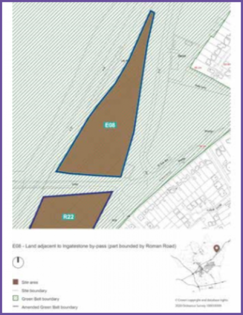
Map 6: Employment land allocation E08, land adjacent to A12 and slip road, Ingatestone20
- Land adjacent to the A12 and slip road, Ingatestone, identified in the Policies Map as Site E08, is allocated for 2.06ha of employment land. The following uses are permitted on this site:
- E(g), B2, B8 and any associated employment generating sui generis uses as principle uses on site.
- E(a,b,c,) C2, E (e-f) and E (d) ancillary uses, where it is demonstrated that the location of these uses will not inhibit the operation of the principle uses on the site.
- The parish council will be supportive of development proposals which increase. employment opportunities in the local area and support the local economy. To enhance the local economy in an appropriate and sustainable manner, employment generating development proposals will be supported where they:
- Diversify the local economy e.g. technology/business park.
- Enable new businesses to locate within the parish, e.g. financial and healthcare facilities.
- Protect, support and improve existing businesses and employment land within the parish.
- Provide benefits to the local economy and community which outweigh any harmful impacts of the proposals.
- Are located in areas which are accessible to the surrounding highways network and sustainable transport network including public transport services and cycle and pedestrian routes, without having a significant detrimental impact on the levels of traffic or congestion in the parish.
- Will not detrimentally impact upon residential amenity, health and quality of life of existing residents.
- Provide additional tourist attractions and/or facilities for visitors within the parish.
- Provide infrastructure which supports the use of ultrafast broadband and 5G mobile telecommunications.
- Sections of Ingatestone High Street identified in the Policies Map are designated as Primary Retail Frontage Areas. Development proposals which support and enhance retail and associated ancillary uses (E uses, E(e-f) and F1 and sui generis uses typically found in centres) on ground floors in this area will be supported and encouraged.
- The design of shop fronts in the Primary Retail Frontage Area should seek to maintain and enhance the character of Ingatestone High Street as the centre of the village, particularly through active retail frontages at the ground floor level facing the High Street.
[15] Rural Community Profile for Ingatestone and Fryerning, Rural Community Council for Essex (RCCE), 2013.
[16] Unless specified otherwise, all statistics are from 2011 census data.
[17] An elementary occupation consists of simple and routine tasks, such as cleaners, agricultural labourers, food preparation assistants and refuse workers.
[18] Brentwood Business Partnership is a partnership between Brentwood businesses, local business organisations and Brentwood Borough Council. The Partnership seeks to raise awareness of Brentwood as a thriving place for businesses, visitors and residents; increase footfall and encourage local spend to grow the local economy; support retailers, businesses, tourism and the night-time economy; and sponsor events and projects to attract more business and improve the public realm. Further information is available from: http://www.discoverbrentwood.co.uk/Business/brentwood-business-partnership.asp.
[19] Rural Community Profile for Ingatestone and Fryerning, Rural Community Council for Essex (RCCE), 2013.
[20] Map from the Brentwood Borough Local Plan, pre-submission version, February 2019