Ingatestone & Fryerning Neighbourhood Plan Regulation 16
INTRODUCTION
WHAT IS NEIGHBOURHOOD PLANNING?
The 2011 Localism Act introduced new powers for local communities to produce neighbourhood plans, which can be used to guide and shape future development in an area. Once 'made' (adopted), a neighbourhood plan forms part of the statutory Development Plan for the area and it is used in the determination of planning applications alongside the Brentwood Local Development Plan (BLDP) and other material planning considerations, including the National Planning Policy Framework (NPPF)[1].
Neighbourhood plans must be subject to public consultation, examination and local referendum prior to adoption and policies contained within a neighbourhood plan should be supported by evidence based documents and Strategic Environment Assessment/Habitats Regulation Assessment as necessary. Neighbourhood plans must accord with the overall aims and objectives of the NPPF, particularly in relation to supporting and promoting sustainable development.
Neighbourhood plans give communities direct power to guide and shape future development. Where a Neighbourhood Plan is aligned with the strategic needs and priorities of the wider local area, neighbourhood planning can provide a powerful set of tools for local people to ensure that future development meets the needs and requirements of the local community.
The Planning Practice Guidance[2] states that a neighbourhood plan must meet the basic conditions set out in paragraph 8(2) of Schedule 4B to the Town and Country Planning Act 1990[3]. The submission of the final version of the Ingatestone and Fryerning Neighbourhood Plan to Brentwood Borough Council (BBC) will include a statement setting out how the plan meets the requirements of the basic conditions set out below:
- The neighbourhood plan has regard to national policies and advice contained in guidance issued by the Secretary of State.
- The making of the neighbourhood plan contributes to the achievement of sustainable development.
- The making of the neighbourhood plan is in general conformity with the strategic policies contained in the Local Plan.
- Prescribed conditions are met in relation to the neighbourhood plan and prescribed matters have been complied with in connection with proposals within the neighbourhood plan.
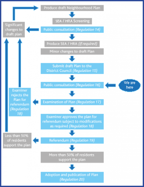
Figure 1: Guide to producing a neighbourhood plan
The Neighbourhood Planning (General) Regulations 2012 (as amended) set out the statutory stages which must be completed in the production of a neighbourhood plan. Figure 1 presents this process and identifies which stage we are currently at in the production of the IFNP.
WHY DOES INGATESTONE AND FRYERNING PARISH NEED A NEIGHBOURHOOD PLAN?
Neighbourhood planning gives communities direct power to develop a shared vision and shape the development and growth of their local area. Community groups can produce plans that have real statutory weight in the planning system to shape future growth. The production of a neighbourhood plan provides the community with the opportunity to establish objectives and requirements to guide and manage future development proposals in the parish in order to ensure that local needs are met, but also to ensure that the valued characteristics of the parish can be maintained and protected for future generations.
PROGRESSION OF THE INGATESTONE AND FRYERNING NEIGHBOURHOOD PLAN
The concept of producing a neighbourhood plan for Ingatestone and Fryerning parish was first presented to the community at the Ingatestone and Fryerning Horticultural Show on Saturday 15 July 2017. This was followed by further information on neighbourhood planning being published in the August 2017 Ingatestone and Fryerning Parish Council newsletter, which is delivered to every household in the parish.
In October 2017, BBC designated Ingatestone and Fryerning Parish as a Neighbourhood Area for the purposes of producing a neighbourhood plan, and the Neighbourhood Plan Advisory Committee (NPAC) was established to support the parish council in developing the IFNP.
Residents and stakeholders were invited to participate in the committee using social media and the Ingatestone and Fryerning Parish Council website. The terms of reference for the committee were formulated and agreed by the parish council in November 2017.
Since 2017, the NPAC has undertaken extensive research and analysis of current and potential future issues in the parish and undertaken a range of community events in order to inform the production of the draft IFNP.
During summer 2018 a questionnaire was posted to all households and businesses in the Parish. The analysis of responses to the questionnaires has been an important component in formulating the vision, aims, objectives and policies contained within the draft IFNP.
PURPOSE OF THE REGULATION 16 CONSULTATION ON THE INGATESTONE AND FRYERNING NEIGHBOURHOOD PLAN
As outlined in Figure 1, the Neighbourhood Planning (General) Regulations 2012 (as amended) require the neighbourhood plan to be subject to public consultation before the plan can be submitted for examination. The requirements for this stage of public consultation are set out within Regulation 16 of the Neighbourhood Planning Regulations.
HOW TO MAKE COMMENTS ON THE DRAFT INGATESTONE AND FRYERNING NEIGHBOURHOOD PLAN
In addition to meeting the 'basic conditions', the IFNP should represent the views of residents of the parish, as well as people and organisations who have an interest in the future of the area. Ingatestone and Fryerning Parish Council therefore welcomes your views on this Regulation 16 Neighbourhood Plan.
Details as to how you can respond are provided at https://brentwood.oc2.uk/instructions.
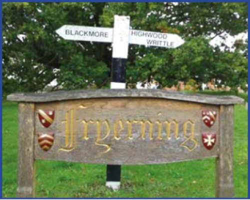
ABOUT INGATESTONE AND FRYERNING PARISH
Location and context
The parish of Ingatestone and Fryerning is located in the Borough of Brentwood, Essex. The designated Neighbourhood Area for the purposes of producing the Neighbourhood Plan is consistent with the parish boundary presented in Map 1.
Ingatestone and Fryerning parish includes two villages surrounded by Metropolitan Green Belt and open farmland. The villages have a combined population of 4,785 people[4], including 2,095 households.
The main settlement of Ingatestone is excluded from the green belt and lies within an area bounded by the railway to the east, the A12 trunk road to the west, New Road to the north and the Hey Brook to the south. Fryerning and the surrounding small settlements of Mill Green and Beggar Hill are all situated within the Green Belt. The parish is bounded by the River Wid to the south east and much of the west consists of woodland.
Map 1: Parish boundary. Copyright Phill Poston.

Villages in the parish have a rural atmosphere, character and appearance. Short walks from the centre of Ingatestone and Fryerning lead into open fields with a good network of public footpaths and bridleways in the green belt. There are small local businesses and a good range of shops and services within the local villages.
History
Both Ingatestone and Fryerning have their origins in the Saxon period when Ingatestone was called 'Ingattestone' and Fryerning was 'Friarsing'. 'Ing', a common Saxon word, could mean pasture, possession of, or settlement. Therefore, 'Ing Atte Stone' could have meant 'settlement at the stones' and 'Friars Ing' 'Friars settlement'. The stones relate to sandstone blocks known as 'sarsens stones', two of which exist on the junction of Fryerning Lane and the High Street.
From about 950AD, Ingatestone was in the possession of Barking Abbey, but with the dissolution of the monasteries in 1539 it was sold by the crown to Doctor William Petre who had Ingatestone Hall built in the 1540's.
After the Norman Conquest, Fryerning was given to the Norman baron Robert Gernon and passed to the Knights Hospitallers of St. John until the order was dissolved by Henry VIII in 1540. The estate was eventually passed to Nicholas and Dorothy Wadham in 1607, who founded Wadham College in Oxford. On their deaths the estate passed into college ownership and much of it remains in their hands to this day.
Ingatestone developed alongside the route of the old Roman Road built to connect London with Roman outposts such as Colchester. Very early maps show ribbon development along the road edges which include buildings such as The Crown pub.
Ingatestone was a day's ride on horseback from London, and therefore became an important location for stagecoaches and Royal Mail coach horses to be changed and travellers to rest for the night. As a result there were large numbers of inns, in addition to a blacksmiths, wheelwrights and harness makers. Before the advent of the railway around 50 coaches a day would pass through the village. Only The Bell pub remains on the Roman Road, where as many as 20 inns would once have existed. The railway arrived in 1843 and the stagecoach trade ceased. Ingatestone Station was built in 1846 and is now located in Station Lane between Ingatestone Hall and the village centre.
Market Place, in the centre of Ingatestone has a mural depicting some of the villages' history. Ingatestone and Fryerning formed one Civil Parish in 1889. The Roman Road passing through the village was the A12 trunk road. However, increases in traffic levels resulting in congestion in the narrow High Street led to the building of the bypass in 1958/9.
Conservation areas
Ingatestone's High Street Conservation Area was established in November 1969 and contains a large number of grade II listed buildings and a grade I listed parish church.
The Station Lane Conservation Area was established in September 1981 and includes many Arts and Crafts style properties designed by George Sherrin, the grade II listed railway station, the Catholic church and Tor Bryan estate. Outside this area is Ingatestone Hall, which includes a listed granary and gatehouse.
The Fryerning Conservation Area was established in March 1991 and contains the listed St. Mary the Virgin Church, Mill Green Windmill, Fryerning Hall and medieval barns and many other listed properties. Mill Green also has evidence of medieval brick kilns where ancient pottery has been found.
Services and facilities
Ingatestone has several churches of different denominations, two church halls, an infant and junior school and the Anglo European School. There are preschools, playgroups and a nursery. Christy Hall provides space for community groups and events.
A good range of shops, public houses, wine bars, restaurants and cafés exist along the High Street, with free two-hour parking bays in the Market Place and Bell Mead. Shops include two supermarkets, a florists, a delicatessen, clothes shops, stationers, jewellers, hardware store, off-licence, galleries, hairdressers, newsagents and more. Other services include a post office, estate agents, optician, veterinary surgery, doctor's surgery, dentist and an undertaker.
Fryerning village includes two public houses, a church and the Fryerning Parish Rooms.
Parks and leisure facilities
Recreation facilities exist on Fairfield, leased from Lord Petre by the parish council, where cricket matches are played in the summer. There is a cricket pavilion, two children's play areas and a historic pond. Mill Green Common, owned by Lord Petre, is available for use, as is Seymour Field, leased from Brentwood Borough Council.
Seymour Field and its newly renovated pavilion (Figure 21) are managed by the parish council. There are a number of playing fields used by local football teams and it hosts the annual horticultural show. The Community Club (Figure 23) on the High Street has a hall and stage for shows and events, a members' bar, tennis courts (Figure 26) and a bowling green (Figure 24) to the rear.
Fishing lakes and two allotment sites (Figure 25) exist within the parish and there is a common at Mill Green in Fryerning. Christy Hall hosts guides, scout groups and clubs.
Local planning context
New development in the parish is currently guided by the policies contained within the adopted Brentwood Replacement Local Plan, together with other material considerations (including National Planning Policy). The Local Plan sets a framework for future growth in the area, identifying the level of need and locations for new housing, employment and retail development. The Local Plan also includes specific policies which guide the design, scale, impact and location of new development and infrastructure, as well as policies related to protecting and enhancing heritage assets, the environment, town centres and rural areas.
The Brentwood Replacement Local Plan (BRLP) was adopted in 2005 and includes saved policies from 2008. This document forms the Development Plan for the Borough. BBC are updating the BRLP through the emerging draft Brentwood Local Development Plan (BLDP), which once adopted will form the new Development Plan for the area. Consultation on the draft BLP was undertaken in 2016 and 2018 and consultation on the pre-submission BLP was undertaken in February 2019. Further consultation on 'focused changes' to the pre-submission BLP was undertaken in November 2019 and it is expected that the BLP will be submitted to the Secretary of State for examination in 2020.
Essex County Council (ECC) is the Waste Planning Authority (WPA) for the Plan area and is responsible for preparing planning policies and assessing applications for waste management development. The Essex and Southend-on-Sea Waste Local Plan (WLP) was adopted in July 2017 forming part of the statutory Development Plan and should be read alongside the Brentwood Local Plan and the emerging IFNP. The WLP covers the period from 2017 to 2032. It sets out where and how waste management developments can occur and contains the policies against which waste management planning applications are assessed.
ECC is the Minerals Planning Authority for the Plan area and is responsible for preparing planning policies and assessing applications for mineral development. The Essex Minerals Local Plan 2014 (EMLP) forms part of the statutory Development Plan and should be read alongside the Brentwood Local Plan and the emerging IFNP.

[1] National Planning Policy Framework, HM Government, February 2019.
[2] The Planning Practice Guidance (PPG) is an online portal which provides guidance on implementing aims and objectives of the NPPF. The PPG provides specific guidance on a range of planning related topics.
[3] See paragraph 65 of the PPG.
[4] 2011 Census, Office for National Statistics, 2011.