Strategic Growth Options
5 Environmental Protection & Enhancement
It is important to consider the local environment and policy designations when assessing locations for growth. 89% of Brentwood Borough is within Green Belt, the 6th highest in England by percentage of total area. In addition, there are important environmental features to consider such as Sites of Special Scientific Interest (SSSIs), open spaces and flood zones. This section also sets out the differences in landscape character throughout the Borough.
Green Belt
5.1 The Council greatly values the high quality natural environment of the Borough. It recognises this is protected by the Green Belt and the valuable asset this represents. 89% of Brentwood Borough is Green Belt. The Borough is ranked 6th highest in England (most Green Belt within an authority’s boundary expressed as a percentage of total area). This is important not only because of Brentwood’s location on the edge of London and the green space2 it provides, but also because it constrains opportunities for growth.
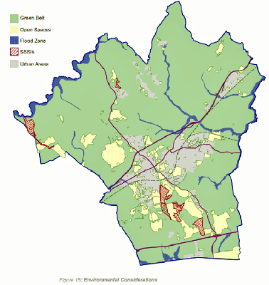
5.2 The following map shows the extent of the Green Belt within Brentwood Borough. As can be seen, this is land outside urban areas (towns and villages). Some smaller villages and hamlets are washed over by Green Belt, such as Fryerning, Great Warley and South Weald.
5.3 Any housing provision over 2,500 homes within Brentwood Borough will need to consider the use of Green Belt. This is the amount that could be sustainably developed on available brownfield land. There are also other development needs, such as employment.
Other Environmental Considerations
5.4 In addition to the Green Belt, other issues need to be considered when identifying suitable locations for new development. For example, these include the environmental impact on water, biodiversity and open space.
Heritage
5.5 The Council is committed to safeguarding the heritage of the borough and enhancing the character of the area by conserving and, where appropriate, enhancing heritage assets and their settings. These assets include Listed Buildings, Scheduled Ancient Monuments as well as designated Conservation Areas.
Landscape character
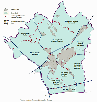
5.6 In 2007, the Council undertook an assessment of landscape character for the borough. The Council is undertaking a further assessment of the landscape capacity in surrounding urban areas in line with the emerging spatial strategy. This assessment will be available to view soon and published on the Council’s website at www.brentwood.gov.uk/localplan
5.7 The areas defined by this study, and the character identified within each are shown on the map. The areas can largely be described as farmland, wooded farmland or valley landscapes.
(530)
 Q9: Are there opportunities
for more open space provision in the area where you live?
 More information
on Landscape Character and other environmental
considerations are available to view at www.brentwood.gov.uk/localplan.
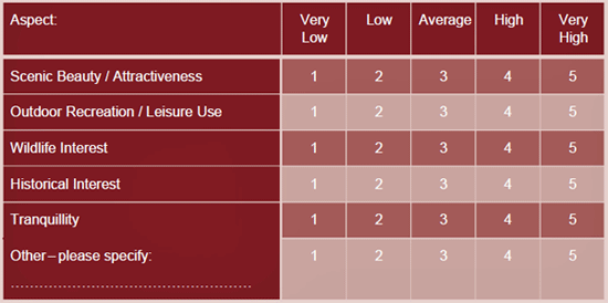
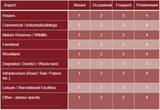
5.8 As part of the landscape evidence currently being undertaken, it would be helpful to gain an insight into how people view their local landscape where they live. Answering the following two questions will help inform the landscape evidence before it is published, which will then inform decisions made as part of the Plan-making process.
(530)
 Q10: Please rate the level
to which you value the landscape near where you live(on a a
scale of 1 to 5), as compared to other areas within
Brentwood Borough, for the following aspects:

(517)
 Q11: To what extent do you
think the following is present in the landscape near where
you live:

2 http://www.planningblog.planningresource.co.uk/2014/03/14/data-blog-whichauthorities-are-most-constrained-by-the-green-belt/[accessed 11.11.14]


