Strategic Growth Options
3 Sustainable Communities
The Council is required to meet projected local housing needs. This need is significantly higher than previous requirements and the amount of new homes built in previous years. This section sets out the key issues and sites that have been suggested to the Council to meet housing need.
Housing Issues
3.1 The Council is required to meet projected local housing needs. The NPPF sets out that Local Planning Authorities should objectively assess their market and affordable housing need and provide for that in full.
3.2 The issue for the Borough becomes apparent when applying the full objectively assessed need against local constraints (such as capacity issues for roads, schools, GPs etc) and local planning policies (such as Green Belt). The capacity of all brownfield within urban areas in the Borough could provide for a maximum of 2,500 new homes (approximate). That means any housing provision above this would need to consider use of Green Belt land.
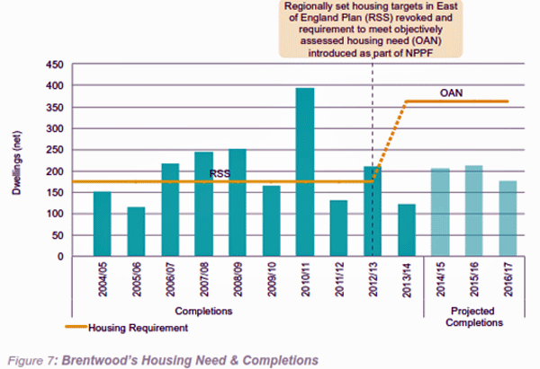
3.3 The Council has commissioned a study to identify objective housing need for the Borough, which concludes a requirement to provide for around 360 new homes per year. The previous target in the East of England Plan was 175 homes per year. Over 15 years that comes to around 5,500 homes, some 3,000 more than what can be provided from brownfield sites in urban areas. The shortfall from previous years will also need to be taken into account in the future Plan period, which will increase the overall housing need figure. If the Plan period is extended to 20 years then the need will also increase proportionately over that period.
3.4 It is also important to consider the need for more affordable housing, which is becoming more of a local issue as house prices increase. This need now applies to a significant proportion of those looking to buy homes and often relates to the need for ‘first and last time housing’, i.e. those looking to move out of parents’ homes and buy their own first home or perhaps those looking to downsize in older age, both wishing to stay within their local communities.
3.5 Information on affordable housing need is set out in the Council’s Strategic Housing Market Assessment (SHMA). In terms of the Council’s own housing stock this currently is made up of 2,519 homes. The Council’s housing register as of November 2014 is made up of 567 people (i.e. those currently on the Council’s waiting list).
Planning for Gypsies & Travellers
3.6 The Council is required by national policy to meet the needs of Gypsies & Travellers. Proposed draft policy in the 2013 Preferred Options suggested local needs be met by permanently allocating some existing temporary permissions for pitches and providing the remainder as part of mixed-use development at a new strategic allocation. This is in line with national policy in terms of providing pitches in a sustainable way, masterplanned as part of wider development in suitable locations.
Gypsies & Travellers site options
3.7 Existing sites are scattered across locations within both the North of the Borough and A12 Corridor. Not all have been proposed to be made permanent although that is an option.
3.8 In addition to existing pitches, it is proposed that provision of new pitches should be planned into strategic mixed-use allocations, such as options within the A127 Corridor.
 For more
information please see our housing and demographic Evidence
Base available to view at www.brentwood.gov.uk/localplan
For more
information please see our housing and demographic Evidence
Base available to view at www.brentwood.gov.uk/localplan
Housing Site Options
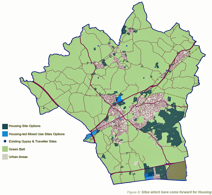
3.9 This map shows the complete selection of sites that have been put forward by landowners and others for consideration as housing sites. These sites have come forward at previous stages of the plan-making process (such as the Strategic Housing Land Availability Assessment (SHLAA) call for sites & the 2013 Preferred Options consultation).
Please click on the image for a larger version
3.10 Not all sites will be necessary to meet the needs of the Borough. In addition, not all sites will be suitable for development, as they will not be in keeping with local aspirations for the form of future development or with sustainability criteria.
3.11 Details of all sites are set out in Appendix 1, by their site reference number. Sites have been suggested to the Council through the plan-making process. Identification of sites does not mean sites will be allocated, or receive planning permission.
Please note, sites
have been suggested to the Council as part of the
plan-making process, including previous consultation.
Identification of sites does not mean that they will be
allocated or receive planning permission. A full list of
all sites is set out in Appendix 1. To view sites in more
detail please visit www.brentwood.gov.uk/localplan
A127 Corridor Housing Site Options
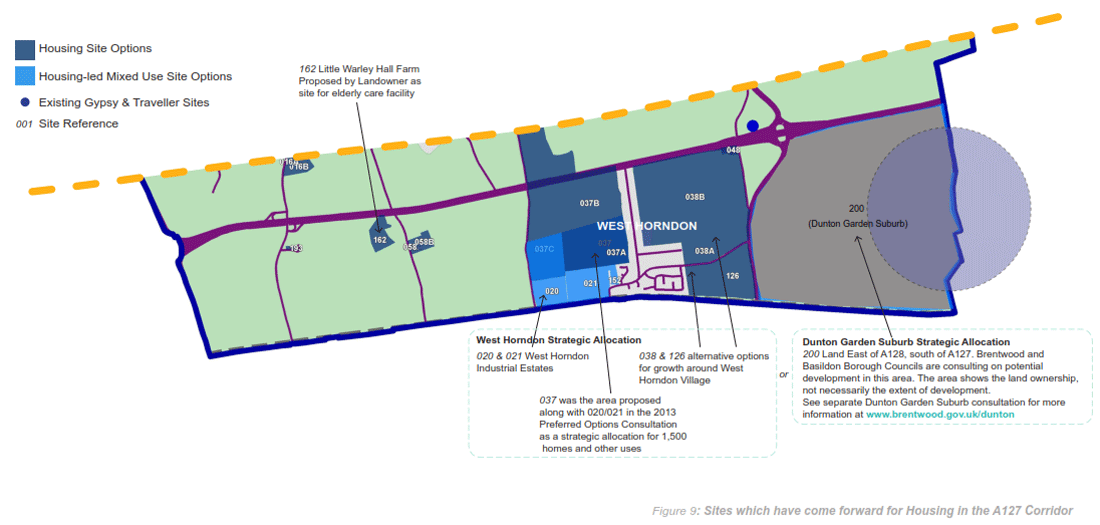
3.12 There is potential for larger growth opportunities in the A127 Corridor as part of strategic mixed-use allocations (residential-led) at West Horndon or cross boundary development at Dunton. The 2013 Preferred Options proposed strategic allocations of residential-led mixed use development at West Horndon Village. An alternative to this could be development at Dunton (See Dunton Garden Suburb Consultation www.brentwood.gov.uk/Dunton). Development along this corridor could provide potential funding for improvements to capacity along the A127.
Please click on the image for a larger version
(609)
 Q4: Given the greater
capacity for growth along the A127 Corridor, which of the
sites put forward do you think is the best location for
growth?
Q4: Given the greater
capacity for growth along the A127 Corridor, which of the
sites put forward do you think is the best location for
growth?
All sites are
options, although not all are annotated with information.
This does not mean that they will be allocated or receive
planning permission. A full list of all sites is set out in
Appendix 1. For more detail visit www.brentwood.gov.uk/localplan
A12 Corridor Housing Site Options
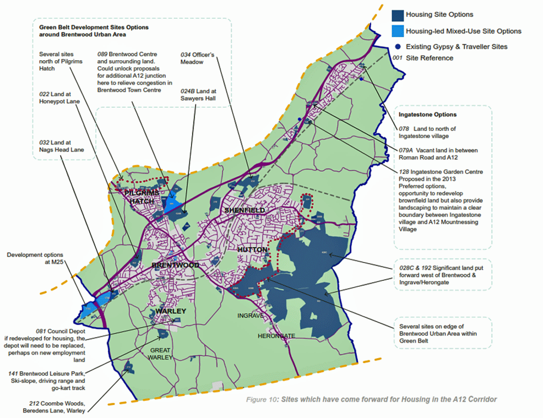
3.13 Sites identified within the A12 Corridor can be separated as follows:
(a) Brownfield land within urban areas, which could be efficiently developed in order to minimise the pressure on Green Belt releases. However, it will be important to consider the impacts such development may have on infrastructure and services, which have already been identified as at or over capacity in many places.
(b) Release of Green Belt sites adjoining the urban areas, which could form sustainable urban extensions. However, development of this kind could have similar negative impacts on infrastructure and services.
Please click on the image for a larger version
(713)
Q5: Should the A12 Corridor
accommodate growth by releasing sites on the edge of urban
areas?
All sites are
options, although not all are annotated with information.
This does not mean that they will be allocated or receive
planning permission. A full list of all sites is set out in
Appendix 1. For more detail visit www.brentwood.gov.uk/localplan
North of the Borough Housing Site Options
3.14 Sites tend to be scattered in the North of the Borough and can be largely separated between greenfield Green Belt sites on the edge of villages and brownfield land within Green Belt, which tends to be near to villages although unconnected. This brownfield land is often made up of industrial uses such as scrap-yards and storage. Depending on the level of local need required for individual villages it may be that one or both of these types of sites could be considered.
3.15 For brownfield sites in the Green Belt, a criteria based policy1could be prepared as part of the Local Plan to ensure that only appropriate sites are redeveloped in accordance with national policy. However, this would mean that alternative locations for lost waste facilities would need to be identified as part of new employment land provision.

Please click on the image for a larger version
(679)
Q6: In order to provide for
local need is it preferable for greenfield sites on the
edge of villages to be released, or to develop brownfield
sites (both within Green Belt)?
All sites are
options, although not all are annotated with information.
This does not mean that they will be allocated or receive
planning permission. A full list of all sites is set out in
Appendix 1. Sites are set out by Ward in Appendix 2. For
more detail visit www.brentwood.gov.uk/localplan
(413)
Q3: Do you have any
comments on the appropriateness of particular sites?
1 This would differ from the standard approach of allocating particular sites. Instead, this approach would involve defining a set of acceptable criteria; if a development proposal could show it met these then it could be permitted.