Preferred Site Allocations 2018
Part Two: Preferred Site Allocations
Brownfield Site Allocations
|
Site Plan:
|
|
|
Site Name: |
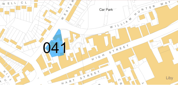
Land at Hunter House, Western Road, Brentwood |
|
Site Reference: |
(10) 041 |
|
Proposed Use(s): |
Housing |
|
Gross Area (ha): |
0.21 |
|
Net Developable Area (ha): |
0.21 |
|
Indicative dwelling yield (net): |
48 |
|
Location and background information: |
Located in Brentwood Town Centre on land adjacent to Western Road, south of William Hunter Way and the western end of the High Street. |
|
Site Access: |
Western Road |
|
Site Opportunities: |
Brownfield town centre site, rear of the High Street, with opportunities to maximise density within close proximity to services and facilities. Early site delivery forecast. |
|
Site Constraints: |
Conservation Area |
|
Delivery Forecast: |
Years 1 - 5 |
|
Site Plan:
|
|
|
Site Name: |
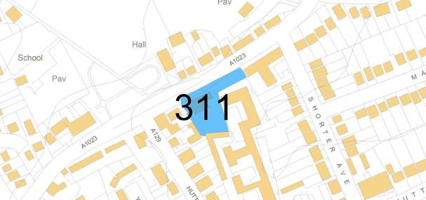
Eagle & Child Pub, Shenfield |
|
Site Reference: |
(14) 311 |
|
Proposed Use(s): |
Housing |
|
Gross Area (ha): |
0.24 |
|
Net Developable Area (ha): |
0.24 |
|
Indicative dwelling yield (net): |
20 |
|
Location and Background Information: |
Shenfield, adjacent to Chelmsford Road (A1023). The Eagle and Child Pub currently occupies the site. Residential properties adjoin the site to the east, south and west. |
|
Site Access: |
Chelmsford Road |
|
Site Opportunities: |
Brownfield site on key transport corridor with forecast early delivery. |
|
Site Constraints: |
Existing buildings on site and potential business loss or relocation. |
|
Delivery Forecast: |
Years 1 - 5 |
|
Site Plan:
|
|
|
Site Name: |
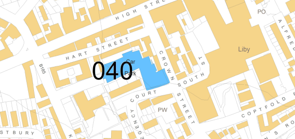
Chatham Way/Crown Street Car Park, Brentwood |
|
Site Reference: |
(39) 040 |
|
Proposed Use(s): |
Housing |
|
Gross Area (ha): |
0.33 |
|
Net Developable Area (ha): |
0.33 |
|
Indicative dwelling yield (net): |
31 |
|
Other indicative uses: |
Public car parking |
|
Location and Background Information: |
Brentwood Town Centre. On land between Chatham Way and Crown Street and the western end of the High Street. |
|
Site Access: |
Chatham Way |
|
Site Opportunities: |
Identified as key opportunity site within Brentwood Town Centre Design Plan. Central site with options to integrate improvements to public realm. To be considered along with site ref: 039 (Westbury Road) and 102 (William Hunter Way) regarding town centre parking provision. |
|
Site Constraints: |
Conservation Area |
|
Delivery Forecast: |
Years 1 - 5 |
|
Site Plan:
|
|
|
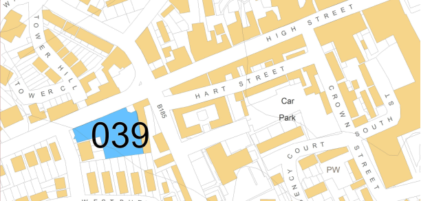
Site Name: |
Westbury Road Car Park, Westbury Road, Brentwood |
|
Site Reference: |
(22) 039 |
|
Proposed Use(s): |
Housing |
|
Gross Area (ha): |
0.27 |
|
Net Developable Area (ha): |
0.27 |
|
Indicative dwelling yield (net): |
45 |
|
Other indicative uses: |
Public car parking |
|
Location and Background Information: |
Located within Brentwood Town Centre. On land south of the High Street and west of Kings Road. Residential properties adjoin the southern boundary and business uses lie to the east. |
|
Site Access: |
Westbury Road |
|
Site Opportunities: |
Key gateway site and identified as an opportunity within the Town Centre Design Plan. High Street location with options to integrate improvements to public realm and strengthen the overall street frontage. To be considered along with site ref: 040 (Chatham Way) and 102 (William Hunter Way) regarding town centre parking provision. |
|
Site Constraints: |
Adjacent Conservation Area/Listed Building |
|
Delivery Forecast: |
Years 1 - 5 |
|
Site Plan:
|
|
|
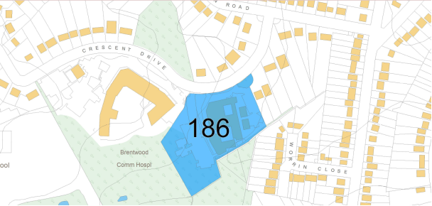
Site Name: |
Land at Crescent Drive, Shenfield |
|
Site Reference: |
(32) 186 |
|
Proposed Use(s): |
Housing |
|
Gross Area (ha): |
1.54 |
|
Net Developable Area (ha): |
1.39 |
|
Indicative dwelling yield (net): |
55 |
|
Location and Background Information: |
Located south west of Shenfield on land adjoining Brentwood Community Hospital. Residential properties adjoin the north, east and southern boundaries. This site comprises the former National Blood Service building and grounds. |
|
Site Access: |
Crescent Drive |
|
Site Opportunities: |
Brownfield site with prospect of early site delivery. |
|
Site Constraints: |
Area of woodland covers the south west of the site. There are existing buildings on site and potential surface water flood risk in parts of the site. |
|
Delivery Forecast: |
Years 1-5 |
|
Site Plan:
|
|
|
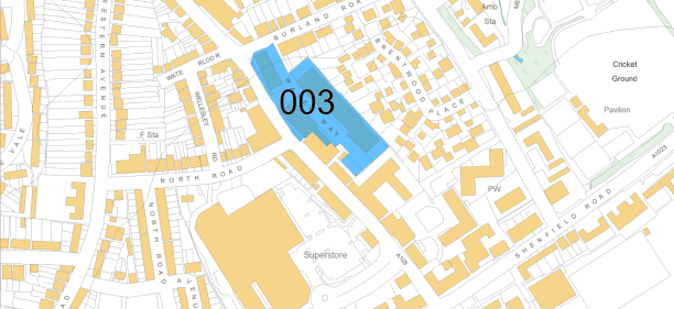
Site Name: |
Wates Way Industrial Estate, Ongar Road, Brentwood |
|
Site Reference: |
(10) 003 |
|
Proposed Use(s): |
Mixed Use – Housing and Retail/Commercial |
|
Gross Area (ha): |
0.99 |
|
Net Developable Area (ha): |
0.89 |
|
Indicative dwelling yield (net): |
80 |
|
Location and Background Information: |
Located within Brentwood Town Centre on land off Ongar Road (A128). Site comprises a number of industrial units which are currently vacant. Residential properties adjoin the north eastern boundary. Retail and residential units adjoin the south east and south western boundaries. |
|
Site Access: |
Ongar Road (A128) |
|
Site Opportunities: |
Brownfield site within central location and easy access of services and facilities. Opportunity to improve appearance of the area and street frontage. |
|
Site Constraints: |
Existing employment/industrial use on site with potential remediation costs. |
|
Delivery Forecast: |
Years 5-10 |
|
|
|
|
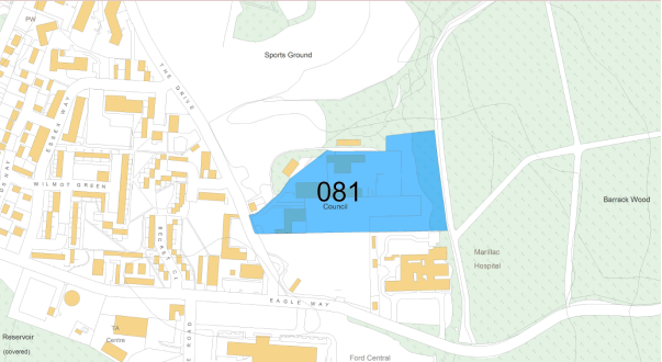
Site Name: |
Council Depot, The Drive, Warley |
|
Site Reference: |
(15) 081 |
|
Proposed Use(s): |
Housing |
|
Gross Area (ha): |
2.98 |
|
Net Developable Area (ha): |
2.24 |
|
Indicative dwelling yield (net): |
123 |
|
Location and Background Information: |
Located to the south of Warley off The Drive. Site is currently used as Council Depot to the north with a car park and Allen Ford service centre to the south. A further large car park area and care home adjoin the southern boundary. Woodland lies to the north and east of the site. |
|
Site Access: |
The Drive |
|
Site Opportunities: |
Masterplan opportunities (potential for mixed use) when considered along with adjoining sites 117A and 117B. |
|
Site Constraints: |
Woodland which adjoins the eastern boundary is designated as a Local Wildlife Site. |
|
Delivery Forecast: |
Years 5-10 |
|
|
|
|
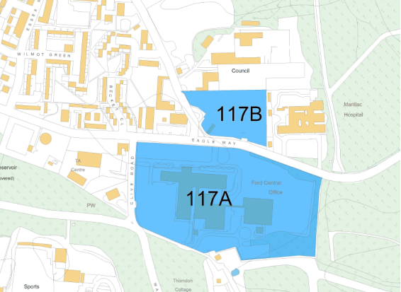
Site Name: |
Ford Offices, Eagle Way, Warley, Brentwood |
|
Site Reference: |
(25) 117A and 117B |
|
Proposed Use(s): |
Housing and Employment |
|
Other indicative uses: |
Specialist accommodation |
|
Gross Area (ha): |
8.09 |
|
Net Developable Area (ha): |
4.00 |
|
Indicative dwelling yield (net): |
350 |
|
Location and Background Information: |
South of Warley on land off Eagle Way. |
|
Site Access: |
Eagle Way |
|
Site Opportunities: |
Masterplan opportunities (potential for mixed use) when considered along with adjoining proposed allocation 081. |
|
Site Constraints: |
Adjoins three Local Wildlife Sites, on the eastern and south western boundary. Two Listed Buildings on adjoining land to the west. |
|
Delivery Forecast: |
Years 10-15 |
|
Site Plan:
|
|
|
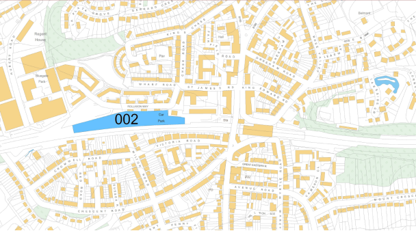
Site Name: |
Brentwood railway station car park |
|
Site Reference: |
(39) 002 |
|
Proposed Use(s): |
Housing |
|
Gross Area (ha): |
1.07 |
|
Net Developable Area (ha): |
0.96 |
|
Indicative dwelling yield (net): |
100 |
|
Location and Background Information: |
Linear site adjacent to railway line and within close proximity to Brentwood Railway Station. Currently used as car parking. |
|
Site Access: |
St James Road, Brentwood |
|
Site Opportunities: |
Strong connectivity to major transport hub with opportunity for high density development. Opportunities to create improved connections and public realm enhancement to railway station and surrounds. Site specific design brief required. |
|
Site Constraints: |
Car parking (station users) will need to be considered as part of redevelopment proposals. Extensive levels of hard surfacing. Potential surface water flood risk in close proximity to railway line. |
|
Delivery Forecast: |
Years 10-15 |
|
Site Plan:
|
|
|
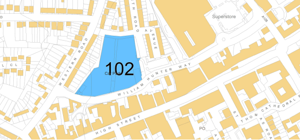
Site Name: |
William Hunter Way Car Park, Brentwood |
|
Site Reference: |
(59) 102 |
|
Proposed Use(s): |
Housing and Retail |
|
Gross Area (ha): |
1.3 |
|
Net Developable Area (ha): |
1.22 |
|
Indicative dwelling yield (net): |
300 (179-300 range) |
|
Location and Background Information: |
Located in Brentwood Town Centre to the north of the High Street along William Hunter Way. Residential properties adjoin the north, east and southern boundaries. Updated headline viability analysis undertaken, suggesting higher residential delivery to fund commercial and parking uses. |
|
Site Access: |
William Hunter Way |
|
Site Opportunities: |
Identified as key opportunity site within Brentwood Town Centre Design Plan. Masterplan to be developed with full consideration of the evident sensitive site edges, inclusion of houses in the masterplan to respond to lower scale at site boundary |
|
Site Constraints: |
Extensive levels of hard surfacing. Sufficient levels of car parking will need to be provided. Adjoins Conservation Area. |
|
Delivery Forecast: |
Years 5-10 |
|
Site Plan:
|
|
|
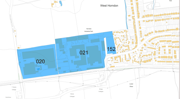
Site Name: |
West Horndon Industrial Estate, Childerditch Lane and Station Road, West Horndon |
|
Site Reference: |
(39) 020, 021 and 152 |
|
Proposed Use(s): |
Housing |
|
Other indicative uses: |
Specialist accommodation Retention of some employment land Retail, community and health facilities |
|
Gross Area (ha): |
17.06 |
|
Net Developable Area (ha): |
10.23 (residential) |
|
Indicative dwelling yield (net): |
580 |
|
Location and Background Information: |
Located to the south west of West Horndon. Site comprises an existing employment site. Existing residential dwellings adjoin the eastern boundary of the site. West Horndon railway station is to the south east. |
|
Site Access: |
Station Road and Childerditch Lane |
|
Site Opportunities: |
Site requires a comprehensive masterplan and phasing strategy. Clear opportunities to create a new village centre with enhanced facilities plus significant residential and specialist accommodation options. Site is located within close proximity to a major transport hub and higher density development options are possible on parts of the site. Opportunities to create improved connectivity to the railway station with public realm and highway improvements. |
|
Site Constraints: |
This is an active industrial estate and therefore phased redevelopment would be required. Potential retention of some employment land (lease arrangements). Possible site contamination and remediation costs. Flood risk in parts of the site. Multiple land ownerships. |
Greenfield Land within Settlement Boundaries
|
|
|
|
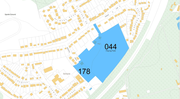
Site Name: |
Land at Priests Lane, Shenfield |
|
Site Reference: |
(900) 044 and 178 |
|
Proposed Use(s): |
Housing |
|
Gross Area (ha): |
5.12 |
|
Net Developable Area (ha): |
3.84 |
|
Indicative dwelling yield (net): |
95 |
|
Location and Background Information: |
Located to the south of Shenfield on land off Priests Lane. Railway line is adjacent to the south eastern boundary and residential properties adjoin the north east and north western boundaries. |
|
Site Access: |
Priests Lane (Potential for secondary access via Bishops Walk) |
|
Site Opportunities: |
Potential option to utilise some of the land for expansion of adjoining Endeavour School off Hogarth Avenue. Masterplan to be based on contextual analysis, informing typologies, scale, materiality and landscaping. |
|
Site Constraints: |
Localised traffic impacts will require consideration. Currently designated Protected Urban Open Space in Brentwood Replacement Local Plan 2005. |
|
Delivery Forecast: |
Years 1-5 |
Brentwood Urban Area – A12 Corridor – Urban Extensions
|
Site Plan:
|
|
|
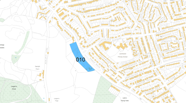
Site Name: |
Sow and Grow, Ongar Road, Pilgrims Hatch |
|
Site Reference: |
(56) 010 |
|
Proposed Use(s): |
Housing |
|
Gross Area (ha): |
1.2 |
|
Net Developable Area (ha): |
1.08 |
|
Indicative dwelling yield (net): |
38 |
|
Location and Background Information: |
Located to the south west of Pilgrims Hatch on land off Ongar Road. Site currently comprises a garden centre, timber supplies business and residential dwellings to the south. Allotments to the west (not included in proposed allocation) |
|
Site Access: |
Ongar Road |
|
Site Opportunities: |
Brownfield development opportunity |
|
Site Constraints: |
Existing business uses operating on site. South Weald Park, designated as an Historic Park and Garden is situated to the south west of the site. |
|
Delivery Forecast: |
Years 1-5 |
|
Site Plan:
|
|
|
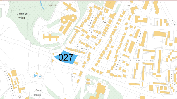
Site Name: |
Land adjacent to Carmel, Mascalls Lane, Warley |
|
Site Reference: |
(22) 027 |
|
Proposed Use(s): |
Housing |
|
Gross Area (ha): |
0.34 |
|
Net Developable Area (ha): |
0.34 |
|
Indicative dwelling yield (net): |
9 |
|
Location and Background Information: |
Located to the south of Warley on land off Mascalls Lane. Existing residential properties are adjacent to the north, east and western boundaries. |
|
Site Access: |
Mascalls Lane |
|
Site Opportunities: |
Small early delivery housing site |
|
Site Constraints: |
None |
|
Delivery Forecast: |
Years 1-5 |
|
Site Plan:
|
|
|
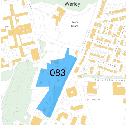
Site Name: |
Land west of Warley Hill, Pastoral Way, Warley |
|
Site Reference: |
(13) 083 |
|
Proposed Use(s): |
Housing |
|
Gross Area (ha): |
2.21 |
|
Net Developable Area (ha): |
1.6 |
|
Indicative dwelling yield (net): |
43 |
|
Location and Background Information: |
Located near the centre of Warley on land west of Warley Hill. Residential properties lie to the north east and north west of the site with woodland adjoining the western boundary. Site contains a number of former NHS properties which are no longer in use. |
|
Site Access: |
Pastoral Way |
|
Site Opportunities: |
Low density development in sustainable location, with opportunity for sympathetic layout considering vegetation on site. |
|
Site Constraints: |
Setting of nearby Listed Buildings will need to be considered. There are a number of trees on site and an adjoining woodland that also will require consideration. Defensible Green Belt edge will need to be defined. |
|
Delivery Forecast: |
Years 5-10 |
|
Site Plan:
|
|
|
Site Name: |
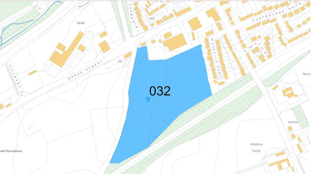
Land east of Nags Head Lane, Brentwood |
|
Site Reference: |
(14) 032 |
|
Proposed Use(s): |
Housing |
|
Gross Area (ha): |
5.88 |
|
Net Developable Area (ha): |
4.35 |
|
Indicative dwelling yield (net): |
125 |
|
Location and Background Information: |
Located to the west of Brentwood on land bounded by the railway line and Nags Head Lane. Residential properties and retail units adjoin the site to the north and further residential properties adjoin the eastern boundary. |
|
Site Access: |
Nags Head Lane |
|
Site Opportunities: |
Self contained urban extension |
|
Site Constraints: |
Impact on nearby Listed Building will need to be considered |
|
Delivery Forecast: |
Years 5-10 |
|
Site Plan:
|
|
|
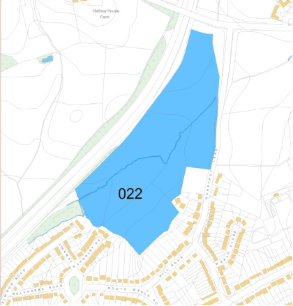
Site Name: |
Land at Honeypot Lane, Brentwood |
|
Site Reference: |
(622) 022 |
|
Proposed Use(s): |
Housing |
|
Gross Area (ha): |
10.93 |
|
Net Developable Area (ha): |
7.09 |
|
Indicative dwelling yield (net): |
200 |
|
Other Indicative Uses: |
C2 – residential care home |
|
Location and Background Information: |
Located in the west of Brentwood on land between the A12 and Honeypot Lane. Residential properties adjoin the south eastern and south western boundaries. St Faiths Park lies to the east on the opposite side of Honeypot Lane. |
|
Site Access: |
Honeypot Lane |
|
Site Opportunities: |
Self contained urban extension. Opportunity to enhance pedestrian links/green infrastructure through St Faiths Park. |
|
Site Constraints: |
Watercourse runs through the middle of the site and will need to be considered. Consideration of proximity of A12. Local highway considerations. |
|
Delivery Forecast: |
Years 5-10 |
|
Site Plan:
|
|
|
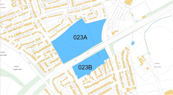
Site Name: |
Land off Doddinghurst Road, either side of A12, Brentwood |
|
Site Reference: |
(30) 023A and 023B |
|
Proposed Use(s): |
Housing |
|
Gross Area (ha): |
Site Ref. 023A: 5.99 Site Ref. 023B: 2.2 |
|
Net Developable Area (ha): |
Site Ref. 023A: 4.49 Site Ref. 023B: 1.65 |
|
Indicative dwelling yield (net): |
200 |
|
Location and Background Information: |
Two parcels of land separated by the A12. The northern parcel sits to the south of Pilgrims Hatch and the southern parcel is to the north of Brentwood. Both parcels adjoin existing residential properties on two boundaries. |
|
Site Access: |
023A: Doddinghurst Road 023B: Russell Close and Karen Close |
|
Site Opportunities: |
Self contained urban extension/infill |
|
Site Constraints: |
023A and 023B: Consideration of proximity of A12. 023B: Southern and eastern areas of the site have potential surface water flooding issues which require consideration. |
|
Delivery Forecast: |
Years 5-10 |
|
|
|
|
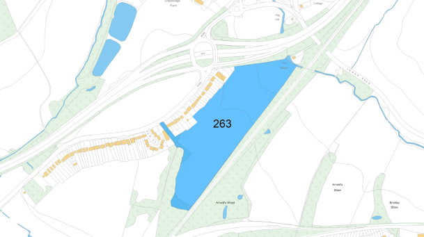
Site Name: |
Land east of Chelmsford Road, Shenfield |
|
Site Reference: |
(25) 263 |
|
Proposed Use(s): |
Housing |
|
Gross Area (ha): |
9.85 |
|
Net Developable Area (ha): |
8.87 |
|
Indicative dwelling yield (net): |
215 |
|
Location and Background Information: |
Located to the north of Shenfield on land between the A1023 Chelmsford Road and the railway line. Existing residential properties are adjacent to the north western boundary. |
|
Site Access: |
Chelmsford Road (A1023) |
|
Site Opportunities: |
Opportunity to create a masterplan along with adjoining proposed allocations (site refs: 158, 034, 087, 235 and 276). Combined development provides opportunity for new primary school provision. Green Infrastructure enhancement opportunities. |
|
Site Constraints: |
Woodland which is designated as a Local Wildlife Site (LoWS) adjoins south western boundary of site. A watercourse feature crosses the north eastern edge of the site. |
|
Delivery Forecast: |
Years 5-10 |
|
|
|
|
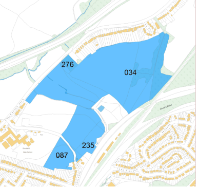
Site Name: |
Officer's Meadow, land off Alexander Lane, Shenfield |
|
Site Reference: |
(47) 034, 087, 235 and 276 |
|
Proposed Use(s): |
Housing |
|
Gross Area (ha): |
24.44 |
|
Net Developable Area (ha): |
15.89 |
|
Indicative dwelling yield (net): |
510 |
|
Other Indicative Uses: |
C2 – Residential Care Home Specialist accommodation Land for education, play pitches |
|
Location and Background Information: |
Located to the north of Shenfield on land between the A1023 Chelmsford Road and the railway line. Residential properties are adjacent to the northern boundary and Shenfield High School is situated to the south west. |
|
Site Access: |
Chelmsford Road (A1023) |
|
Site Opportunities: |
Opportunity to create a masterplan along with adjoining proposed allocations (site refs: 158 and 263). Combined development provides opportunity for new primary school provision. Green Infrastructure enhancement opportunities. |
|
Site Constraints: |
Eastern side of site ref 034 covers a woodland designated as a Local Wildlife Site (LoWS). Water course feature across part of the site and risk of surface water flooding. |
|
Delivery Forecast: |
Years 5-15 |
|
Site Plan:
|
|
|
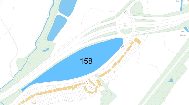
Site Name: |
Land North of A1023 Chelmsford Road, Shenfield |
|
Site Reference: |
(22) 158 |
|
Proposed Use(s): |
Housing and Employment |
|
Gross Area (ha): |
4.45 |
|
Net Developable Area (ha): |
3.44 |
|
Indicative dwelling yield (net): |
100 |
|
Location and Background Information: |
North of Shenfield on land between the A1023 Chelmsford Road and the A12. |
|
Site Access: |
Chelmsford Road (A1023) |
|
Site Opportunities: |
Opportunity to create a masterplan along with adjoining proposed allocations (site refs: 158, 034, 087, 235 and 263) |
|
Site Constraints: |
Due to proximity to Roman Road archaeological investigation likely. Small areas of potential surface water flood risk along the northern edge of the site. Consideration of proximity of A12. |
|
Delivery Forecast: |
Years 5-10 |
Ingatestone village service centre
|
Site Plan:
|
|
|
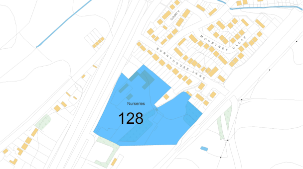
Site Name: |
Ingatestone Garden Centre, Roman Road, Ingatestone |
|
Site Reference: |
(21) 128 |
|
Proposed Use(s): |
Housing |
|
Gross Area (ha): |
3.45 |
|
Net Developable Area (ha): |
2.44 |
|
Indicative dwelling yield (net): |
120 |
|
Location and Background Information: |
Located to the south of Ingatestone and north of Mountnessing on land between the railway line and Roman Road. Residential properties are adjacent to the north eastern boundary with the Mountnessing Recycling Centre to the south west. Part of the site was previously used as a garden centre. An occupied residential bungalow lies within the site to the north west. |
|
Site Access: |
Roman Road |
|
Site Opportunities: |
Brownfield development opportunity, self contained urban extension (with site ref: 106). |
|
Site Constraints: |
Potential issues with surface water flooding in the centre of the site will need addressing as part of any proposals. Consideration of proximity of A12. |
|
Delivery Forecast: |
Years 1-5 |
|
Site Plan:
|
|
|
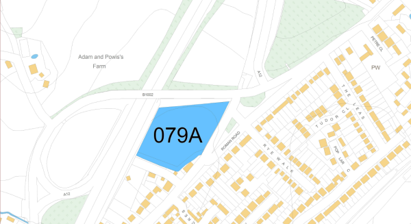
Site Name: |
Land adjacent to Ingatestone by-pass (part bounded by Roman Road, south of flyover) |
|
Site Reference: |
(22) 079A |
|
Proposed Use(s): |
Housing |
|
Gross Area (ha): |
1.39 |
|
Net Developable Area (ha): |
1.25 |
|
Indicative dwelling yield (net): |
57 |
|
Location and Background Information: |
Located to the south of Ingatestone on land between Roman Road and the A12. Residential properties are to the south east and south west. |
|
Site Access: |
Roman Road |
|
Site Opportunities: |
Self contained urban extension |
|
Site Constraints: |
Archaeological investigations may be required due to proximity to Roman Road. Consideration of proximity of A12. |
|
Delivery Forecast: |
Years 1-5 |
|
Site Plan:
|
|
|
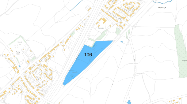
Site Name: |
Site adjacent to Ingatestone Garden Centre (former A12 works site) |
|
Site Reference: |
(20) 106 |
|
Proposed Use(s): |
Housing |
|
Gross Area (ha): |
4.65 |
|
Net Developable Area (ha): |
3.49 |
|
Indicative dwelling yield (net): |
41 |
|
Location and Background Information: |
Located between Mountnessing and Ingatestone with the A12 running along to the north west. Minimal structures on site, temporary works site to the north, haulage operation to the south. |
|
Site Access: |
Roman Road |
|
Site Opportunities: |
Combined with site ref: 128 considered as a self contained urban extension |
|
Site Constraints: |
Potential surface water flooding issues on some sections of the site. Consideration of proximity of A12. |
|
Delivery Forecast: |
Years 1-5 |
larger villages
|
Site Plan:
|
|
|
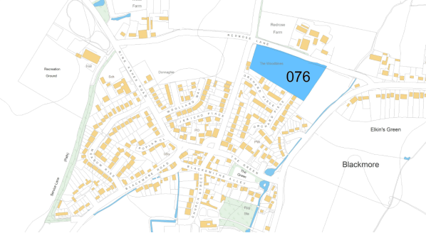
Site Name: |
Land south of Redrose Lane, north of Orchard Piece, Blackmore |
|
Site Reference: |
(205) 076 |
|
Proposed Use(s): |
Housing |
|
Gross Area (ha): |
1.69 |
|
Net Developable Area (ha): |
1.52 |
|
Indicative dwelling yield (net): |
40 |
|
Location and Background Information: |
Located to the north of Blackmore on land off Orchard Piece and Redrose Lane. Existing residential dwellings adjoin the southern boundary. |
|
Site Access: |
Redrose Lane |
|
Site Opportunities: |
Self contained village extension |
|
Site Constraints: |
Access considerations on Redrose Lane. Surface water flooding considerations. |
|
Delivery Forecast: |
Years 1-5 |
|
Site Plan:
|
|
|
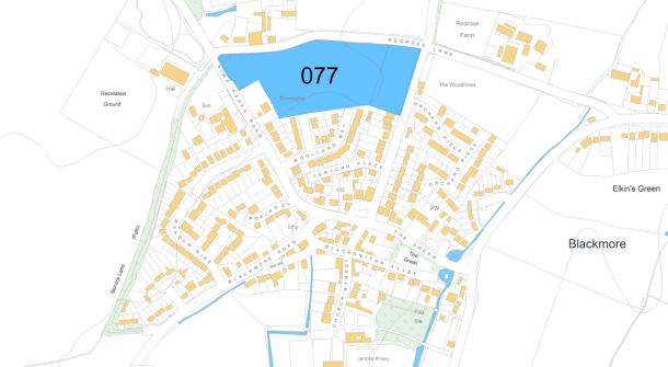
Site Name: |
Land south of Redrose Lane, north of Woollard Way, Blackmore |
|
Site Reference: |
(186) 077 |
|
Proposed Use(s): |
Housing |
|
Gross Area (ha): |
3.3 |
|
Net Developable Area (ha): |
2.48 |
|
Indicative dwelling yield (net): |
56 dwellings |
|
Location and Background Information: |
Located to the north of Blackmore on land off Redrose Lane and Woollard Way. Existing residential dwellings adjoin the southern boundary of the site. |
|
Site Access: |
Redrose Lane |
|
Site Opportunities: |
Self contained village extension |
|
Site Constraints: |
Access considerations on Redrose Lane |
|
Delivery Forecast: |
Years 5-10 |
|
Site Plan:
|
|
|
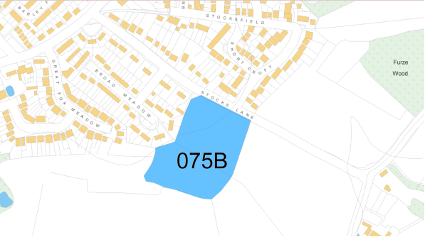
Site Name: |
Land off Stocks Lane, Kelvedon Hatch |
|
Site Reference: |
(12) 075B |
|
Proposed Use(s): |
Housing |
|
Gross Area (ha): |
2.15 |
|
Net Developable Area (ha): |
1.61 |
|
Indicative dwelling yield (net): |
30 |
|
Location and Background Information: |
Located to the south east of Kelvedon Hatch on land off Stocks Lane. Residential properties adjoin the north east and north western boundaries. Land to the south to be used as open space. |
|
Site Access: |
Stocks Lane |
|
Site Opportunities: |
Small village extension |
|
Site Constraints: |
None |
|
Delivery Forecast: |
Years 5-10 |
|
Site Plan:
|
|
|
Site Name: |
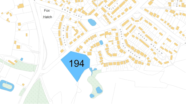
Brizes Corner Field, Blackmore Road, Kelvedon Hatch |
|
Site Reference: |
(13) 194 |
|
Proposed Use(s): |
Housing |
|
Gross Area (ha): |
0.87 |
|
Net Developable Area (ha): |
0.78 |
|
Indicative dwelling yield (net): |
23 |
|
Location and Background Information: |
Located to the south west of Kelvedon Hatch on land off Blackmore Road. Residential properties adjoin the north east and north western boundaries. |
|
Site Access: |
Blackmore Road |
|
Site Opportunities: |
Small village extension |
|
Site Constraints: |
A Local Wildlife Site (LoWS) is situated approximately 80-100m to the south east of the site |
|
Delivery Forecast: |
Years 1-5 |
|
Site Plan:
|
|
|
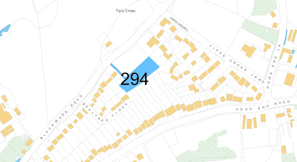
Site Name: |
Chestnut Field, Backmore Road, Hook End |
|
Site Reference: |
(53) 294 |
|
Proposed Use(s): |
Housing |
|
Gross Area (ha): |
0.33 |
|
Net Developable Area (ha): |
0.33 |
|
Indicative dwelling yield (net): |
10 |
|
Location and Background Information: |
Located within Tipps Cross which is connected to the existing Doddinghurst urban area |
|
Site Access: |
Blackmore Road |
|
Site Opportunities: |
Small village infill Consideration should be given to adjoining site ref: 085B |
|
Site Constraints: |
Access would need to be shared with site ref: 085B |
|
Delivery Forecast: |
Years 1-5 |
|
Site Plan:
|
|
|
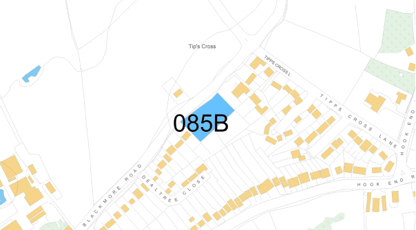
Site Name: |
Land adjacent to Tipps Cross Community Hall, Blackmore Road, Tipps Cross |
|
Site Reference: |
(72) 085B |
|
Proposed Use(s): |
Housing |
|
Gross Area (ha): |
0.33 |
|
Net Developable Area (ha): |
0.33 |
|
Indicative dwelling yield (net): |
10 |
|
Location and Background Information: |
Located within Tipps Cross which is connected to the existing Doddinghurst urban area. |
|
Site Access: |
Blackmore Road |
|
Site Opportunities: |
Small village infill Consideration should be given to adjoining site ref: 294 |
|
Site Constraints: |
Would need to connect with access for site ref: 294 |
|
Delivery Forecast: |
Years 1-5 |
dunton hills garden village
|
Site Plan:
|
|
|
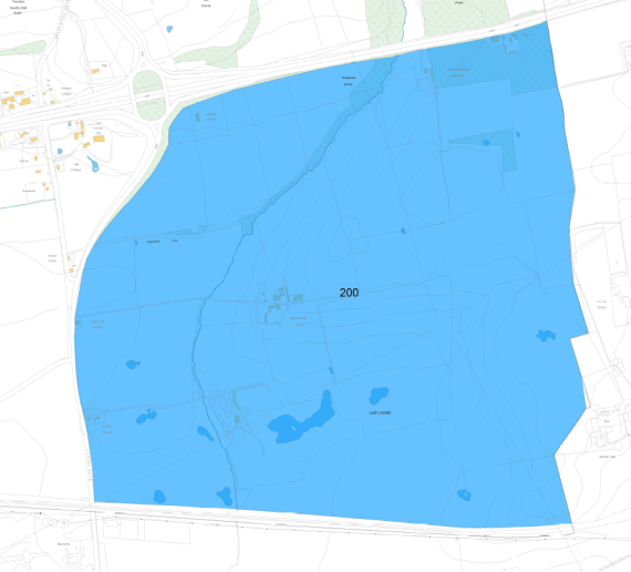
Site Name: |
Dunton Hills Garden Village |
|
Site Reference: |
(193) 200 |
|
Proposed Use(s): |
Mixed Use – New Garden Village community including housing, employment, specialist accommodation, local shops and supporting infrastructure |
|
Gross Area (ha): |
257 |
|
Net Developable Area (ha): |
128.5 |
|
Indicative dwelling yield (net): |
2,500 (within plan period) approx. 4,000 (Total), investigating how accelerated growth could deliver up to 3,500 in plan period |
|
Location and Background Information: |
Located on land to the south of the A127 and east of Tilbury Road (A128). Basildon urban area is situated to the east and West Horndon to the west. |
|
Site Access: |
Tilbury Road (A128) |
|
Site Opportunities: |
New garden village community delivering supporting facilities and services. Green Infrastructure enhancements and new links. |
|
Site Constraints: |
Due to large scale of site needs to be careful consideration of various constraints, this is reflected in the net developable area. |
|
Delivery Forecast: |
Years 5-15 |
Employment Sites
|
Site Plan:
|
|
|
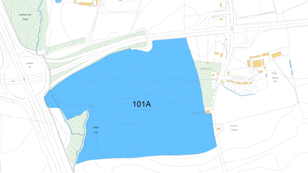
Site Name: |
Brentwood Enterprise Park (Former M25 Works Site at A127/M25 junction 29) |
|
Site Reference: |
(21) 101A |
|
Proposed Use(s): |
Employment |
|
Gross Area (ha): |
35.47 |
|
Developable Area (ha): |
25.85 |
|
Location and Background Information: |
Located on land to the south of the A127 and east of the M25. Warley Street runs along the eastern boundary. Existing residential properties are situated to the east. |
|
Site Access: |
Primary access onto Junction 29 of M25/A127. Potential for secondary bus access onto Warley Street. |
|
Site Opportunities: |
Opportunity to create a strategic employment site, delivering high quality employment space and significant number of jobs. Potential for bus links to be created. Excellent access to strategic highway network. |
|
Site Constraints: |
Southern portion of the site to only be used as a landscaping area. Potential access impact that requires further consideration. |
|
Delivery Forecast: |
Years 5-15 |
|
Site Plan:
|
|
|
Site Name: |
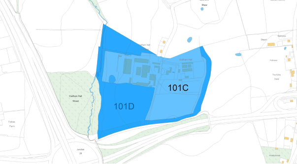
Land at Codham Hall Farm |
|
Site Reference: |
(10) 101C and 101D |
|
Proposed Use(s): |
Employment |
|
Gross Area (ha): |
Site Ref. 101C: 9.62 (Employment area) Site Ref. 101D: 8.01 (Landscaping area) |
|
Net Additional Area (ha): |
0.61 (currently undeveloped land) |
|
Location and Background Information: |
Located on land to the north of the A127 and east of the M25. |
|
Site Access: |
Existing site access directly onto Junction 29 of M25/A127 |
|
Site Opportunities: |
Opportunity to regularise an existing employment site that is not currently identified within the existing Local Plan. |
|
Site Constraints: |
Site ref: 101D to only be used as a landscaping area. Potential access impact that requires further consideration. |
|
Delivery Forecast: |
Years 1-5 |
|
Site Plan:
|
|
|
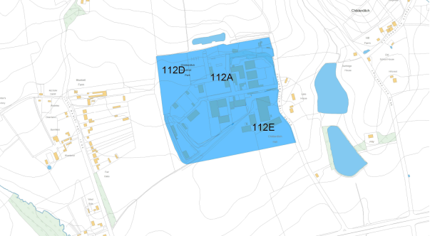
Site Name: |
Childerditch Industrial Estate Extensions |
|
Site Reference: |
(9) 112D and 112E (112A existing Brentwood Replacement Local Plan 2005 allocation) |
|
Proposed Use(s): |
Employment |
|
Gross Area (ha): |
Site Ref. 112D: 2.34 Site Ref. 112E: 7.05 |
|
Developable Area (ha): |
Site Ref. 112D: 2.34 Site Ref. 112E: 3.53 |
|
Location and Background Information: |
Located approximately 400m to the north of the A127 on land off Childerditch Hall Drive. A number of residential dwellings lie to the west of the site. |
|
Site Access: |
A127 (eastbound carriageway) via Childerditch Hall Lane. |
|
Site Opportunities: |
Opportunity to expand an existing employment site and provide improvements. |
|
Site Constraints: |
Direct access onto A127. Nearby residential properties. |
|
Delivery Forecast: |
Years 1-10 |
|
Site Plan:
|
|
|
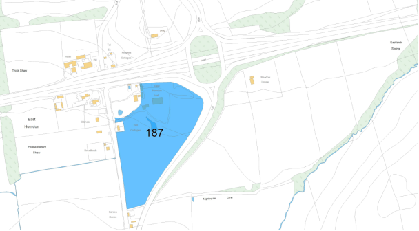
Site Name: |
Land south of East Horndon Hall |
|
Site Reference: |
(11) 187 |
|
Proposed Use(s): |
Employment |
|
Gross Area (ha): |
8.7 |
|
Developable Area (ha): |
5.5 |
|
Location and Background Information: |
Located on land to the east of West Horndon, south of the A127 and west of Tilbury Road (A128). Existing employment operations are located in the north of the site. |
|
Site Access: |
Tilbury Road (west) |
|
Site Opportunities: |
Self contained employment site capable of being linked to Dunton Hills Garden Village proposals. This allows for increased development of new homes at Dunton Hills. |
|
Site Constraints: |
Listed Building to the north. Potential surface water flooding. |
|
Delivery Forecast: |
Years 1-5 |
|
Site Plan:
|
|
|
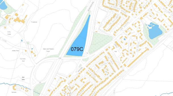
Site Name: |
Land adjacent to Ingatestone by-pass (part bounded by Roman Road) |
|
Site Reference: |
(4) 079C |
|
Proposed Use(s): |
Employment |
|
Gross Area (ha): |
2.06 |
|
Developable Area (ha): |
1.6 |
|
Location and Background Information: |
Located on land to the south west of Ingatestone between the A12 and A12 south off slip. |
|
Site Access: |
Roman Road (B1002) |
|
Site Opportunities: |
Self contained employment site |
|
Site Constraints: |
Highway access considerations. Consideration of proximity of A12. |
|
Delivery Forecast: |
Years 1-5 |
(2) Figure 24: Map of All Preferred Sites