Draft Local Plan
9. ENVIRONMENTAL PROTECTION AND ENHANCEMENT
Policies relating to the natural and historic environment, landscape character, listed buildings and Green Belt
SO9 Safeguard the Green Belt from inappropriate development and enhance its beneficial use SO10 Protect and enhance valuable landscapes and the natural and historic environment
9.1 A fundamental aspect of Brentwood's character is its natural and built environment, central to the unique character which the Plan is in place to protect and enhance. The environment provides the backdrop to our Borough of villages, surrounding settlements with high quality landscape. At the same time the quality of our built environment, which includes several conservation areas and listed buildings, contribute to the feel of the Borough. This benefits residents, workers and visitors. Our environmental qualities are central to why the Borough is a desirable place to be.
9.2 The term environment covers a wide range of issues and so policies are equally wide ranging. Issues covered include the natural and built environment, landscape, archaeology, nature, wildlife and woodland.
9.3 Whilst the Green Belt is not an environmental designation, it is the reason why so much of the Borough's countryside has been historically protected from development. For this reason, Green Belt policies are considered under this chapter alongside other environmental policies. As with all policies, these need to be read in conjunction with overlapping policies from other chapters where relevant.
9.4 Policies in this chapter set out how development impact is to be managed by the need to respect the local environment. Provision for protecting important heritage assets, such as the ruins of the Old Chapel of Thomas Becket, and for ensuring what is built, whether housing or commercial development, maintains and enhances its setting.
9.5 Planning policies recognise the need for limits to housing growth while enabling growth in appropriate locations and considering where integration, conservation and enhancement of the natural and seminatural environment is paramount. This will be achieved by managing development to ensure that the quality of our environment is valued and sustained.
(4)Environment, Landscape, Wildlife and Conservation
9.6 Brentwood's natural and physical environments constitute one of the greatest assets in the Borough. This provides enjoyment for the local community and a great attraction for visitors. Therefore, it is important that the right balance between providing the needed growth during the plan period and the protection and enhancement of the existing environment, where required, is struck. For example, coalescence between the areas for strategic development and neighbouring villages. This section provides policies to guide development alongside the need to protect the environment and the need to maintain a high quality physical and natural environment.
(7)POLICY 9.1: HISTORIC AND NATURAL ENVIRONMENT LANDSCAPE CHARACTER
The Council is committed to safeguarding the diversity and local distinctiveness of the Borough, including its varied landscapes, heritage, biodiversity and habitats. Development should foster a sense of place and local identity, and respect, and where possible, enhance the character of the area. In assessing individual proposals, regard will be given to:
- sensitivity of an area to change;
- importance of retaining the individual identity of separate settlements and parts thereof;
- protecting, conserving and, where appropriate, enhancing heritage assets and their settings in order to conserve their significance;
- potential impact of development on non-designated heritage assets including archaeology;
- conserving and enhancing biodiversity and habitats, including through the creation of new habitats;
- Thames Chase Plan; and
- cumulative impact of development on heritage assets and the natural environment.
The Council will designate and keep under review Conservation Areas in order to protect or enhance their special architectural or historic interest, and will seek to protect the character, significance, and setting of Listed Buildings, Historic Parks and Gardens, and Protected Lanes.
Policy 9.1 contributes towards achieving strategic objective SO7
9.7 The Borough is fortunate to have significant natural and built heritage assets, and these are valued by residents, visitors and business alike. Any future development should therefore conserve, protect and enhance these features.
9.8 National policy requires local authorities to set out a positive strategy in their Local Plan for the conservation and enjoyment of the historic environment. It also states that Local Plans should plan positively for the protection and enhancement of the natural environment. The Council is committed to protecting Brentwood's special and valued historic environment and natural landscapes. This commitment continues to be supported by consultation responses which identify protecting the natural and historic environment as a high priority. The preferred policy approach seeks to ensure that the historic and natural environment is protected and that new development will contribute towards the enhancement of Brentwood's historic and natural environment.
(1)Landscape
9.9 The Mid-Essex Landscape Character Assessment (2006) gives an insight into the Borough's varied landscapes, their qualities, distinctiveness and sensitivity to change. The study identifies three types of landscape in the Borough: wooded farmland, river valley and fenland.
· The vast majority of the rural area is "wooded farmland", comprising undulating areas of deciduous and mixed woodland interspersed with arable fields, mature hedgerows, smaller pastures and paddocks, and narrow lanes with a sense of tranquillity away from the main roads. Several areas of ancient woodland are present. This landscape type is highly sensitive to change.
· The Roding River valley, to the north-west of the Borough, comprises linear patches of woodland, mature hedgerows, a dispersed settlement pattern, sense of remoteness and tranquillity. There are 15 areas of ancient woodland. This landscape type is highly sensitive to change.
· Fenland south of the A127 is characterised by widespread arable agriculture with a flat landscape with a pattern of large fields, large field pattern, hedgerows, distant views south to Tilbury and north to Little Warley and East Horndon Church, and four areas of ancient woodland. This landscape type is moderately sensitive to change.
9.10 In the Mill Green area lies the Forest of Writtle, a designated Ancient Landscape.
Nature Conservation Sites
9.11 The Borough contains three Sites of Special Scientific Interest: Curtis Mill Green, Thorndon Park and The Coppice, Kelvedon Hatch. Recreational impacts already pose a challenge to conserving these sites.
9.12 A Local Nature Reserve at Hutton Country Park and 147 Local Wildlife Sites are identified for their value as semi-natural habitats and for their role in environmental education and public engagement with wildlife. Other natural features of conservation interest include commons, small copses, tree belts, ponds and watercourses, hedgerows and protected lanes.
(2)Historic and Archaeological Heritage
9.13 Registered Parks and Gardens of Special Historic Interest are at Warley Place, Weald Park and Thorndon Park.
9.14 Within the Borough are 13 Conservation Areas: Blackmore, Brentwood Town Centre, Fryerning, Great Warley, Herongate, Highwood Hospital, Hutton Village, Ingatestone Village Centre, Ingatestone Station Area and South Weald, Thorndon Park, Warley Place and Weald Park. 518 buildings are Listed for their Special Architectural or Historic Interest.
9.15 Essex Historic Environment record identifies 636 sites within the Borough of known archaeological interest. These include isolated discoveries like Stone Age flint axe, below ground evidence of prehistoric, Roman, Saxon and medieval occupation and upstanding post medieval and modern structures. Of known sites, 12 are Scheduled Ancient Monuments, including the St Thomas a Becket Chapel in Brentwood Town Centre.
(11)POLICY 9.2: WILDLIFE AND NATURE CONSERVATION
Development proposals affecting Sites of Special Scientific Interest (SSSIs) and National Nature Reserves (NNR) as shown on the Proposals Map and irreplaceable habitats should be controlled through avoidance, on-site management and on-site mitigation. Where this cannot be achieved development proposals will not be permitted.
The Council will take a precautionary approach where insufficient information is provided about avoidance, management and mitigation measures. The Council will secure management, mitigation and enhancement through planning conditions/obligations where necessary.
The Council acknowledge the sensitive biodiversity sites just beyond the borough boundary, including Basildon Meadows SSSI, Norsey Wood SSSI and Epping Forest SSSI and Special Area of Conservation. Proposals likely to have an adverse effect on Special Protection Areas (SPAs), Special Areas of Conservation (SACs) and Ramsar sites will require a full assessment in line with European legislation.
Proposals likely to have an adverse effect on a Local Wildlife Site (LoWS), Local Nature Reserve (LNR), Special Roadside Verge or a site that satisfies the relevant designation criteria will not be permitted unless the benefits of the development clearly outweigh the harm to the nature conservation value of the site. If such benefits exist, the developer will be required to demonstrate that impacts will be avoided, and impacts that cannot be avoided will be mitigated on-site. Where residual impacts remain, offsite compensation will be required to achieve no net loss of biodiversity in the Borough of Brentwood.
Where there is a confirmed presence, or reasonable likelihood, of a legally protected species or priority species on an application site, the applicant will be required to demonstrate that adverse impacts upon the species have been avoided, and where they cannot be avoided adequately mitigated. Mitigation must conform to the requirements of relevant legislation and Natural England Standing Advice. Where impacts cannot be adequately mitigated, the proposal will not be permitted.
Hedgerows must be subjected to an assessment against the criteria of the Hedgerow Regulations 1997. If a Hedgerow is deemed to be Important under the Hedgerow Regulations, the developer must demonstrate that adverse impacts upon the Important Hedgerow will be avoided, and impacts that cannot be avoided are mitigated on-site.
The Council will assess sites proposed for development to ascertain whether they fulfil the criteria for designation and may request information from applicants to assist in that process. If a site satisfies the criteria it will, for planning purposes, be treated as if it were a LoWS/LNR.
All stages of development must be considered when assessing the impact and cumulative impact on wildlife sites both within and in proximity to the Borough of Brentwood.
The Council will take a precautionary approach where insufficient information is provided about avoidance, management, mitigation and compensation measures. The Council will secure management, mitigation and compensation measures through planning conditions/obligations where necessary.
Proposals that result in a net gain in Priority Habitat will in principle be supported, subject to other policies in this plan. Where Priority Habitats are likely to be adversely impacted by the proposal, the developer must demonstrate that adverse impacts will be avoided, and impacts that cannot be avoided are mitigated onsite. Where residual impacts remain, offsite compensation will be required so that there is no net loss in quantity and quality of Priority habitat in the Borough of Brentwood.
Where development is permitted, the Council will require appropriate mitigation and compensatory measures to be provided. Such features include but are not limited to:
- Hedgerows and field walls;
- Trees, woodlands, plantations and shelter belts;
- River corridors;
- Wetlands, ponds and reservoirs,
- Soft landscaping; and
- Other locally important habitats.
9.16 The Council is committed to the protection and enhancement of the natural environment. The National Planning Policy Framework provides strong support for the protection, conservation and management of the Borough's natural assets and landscape character. It recognises the intrinsic character and beauty of the countryside as a core planning principle, whether that countryside is specifically designated or not. Policy 9.2 should be read in conjunction with Policy 9.1 Historic, and Natural Environment and Landscape character, and Policy 9.3 Landscape Protection and Woodland Management.
9.17 The borough has three Sites of Special Scientific Interest Curtismill Green, Thorndon Country Park and The Coppice, Kelvedon Hatch. There are also 142 local sites.
9.18 The Council has a duty under the Natural Environment and Rural Communities (NERC) Act 2006 and the Wildlife and Countryside Act 1981 to have regard to biodiversity conservation and the positive conservation management (PCM) of Local Wildlife Sites (LoWS) within the Borough (formerly known as Sites of Importance for Nature Conservation or County Wildlife Sites). Brentwood Local Wildlife Site Review (2012) identifies networks of LoWS and the diverse assemblage of ecologically important sites within the Borough.
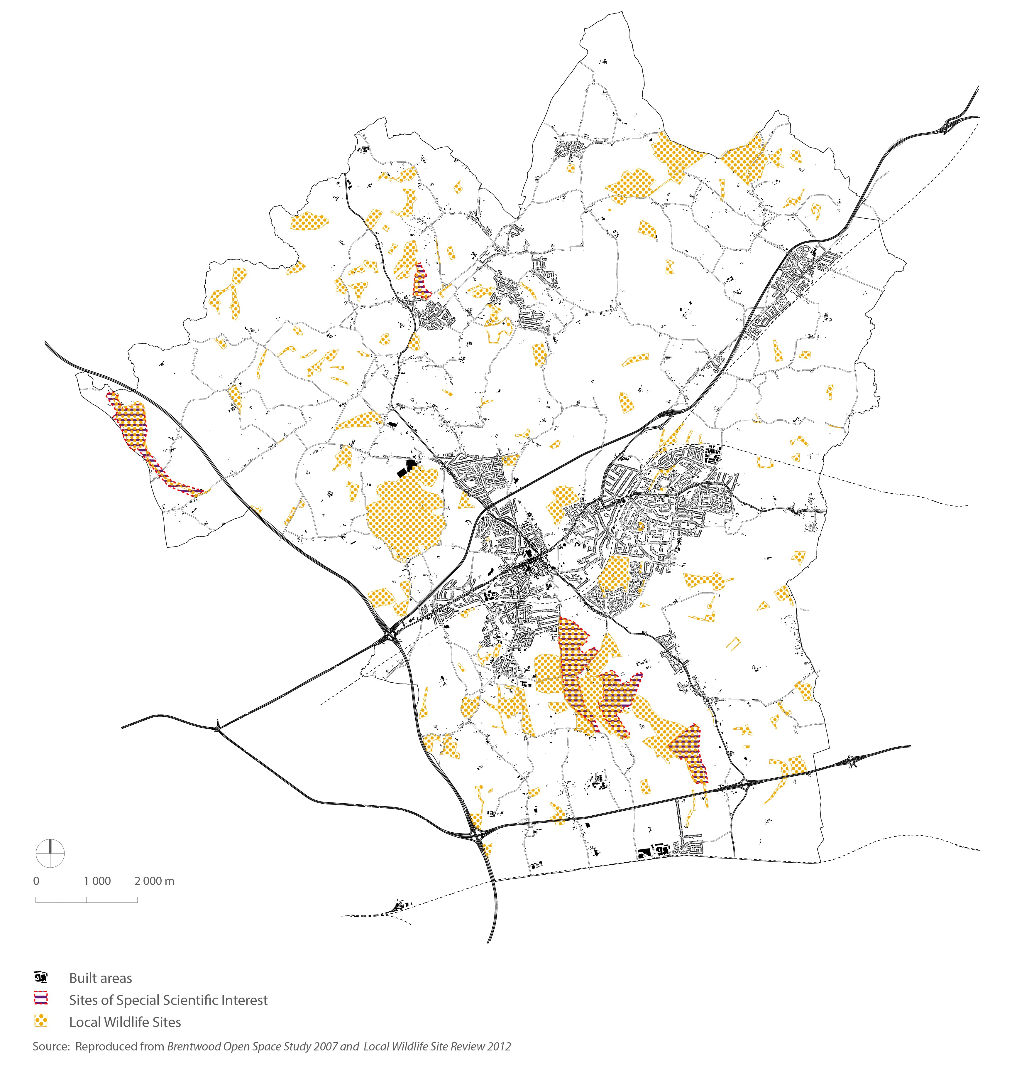
(1)FIGURE 9.1: Environment and Biodiversity
9.19 Where appropriate, all proposals must conform to Essex Biodiversity Action Plan, which provides district wide targets and outlines habitats of special local significance. Within Brentwood, the latter can be categorised into commons, public and private woodlands, tree belts, lowland grassland, lakes and ponds, hedgerows and a number of protected lanes. Development in the Borough will increase the recreational pressures on existing sensitive habitats, avoidance and reduction of the potential effects by sensitive layout and design of green infrastructure will be required in line with the scale of the development. Proposals should refer to paragraph 10.10 Green Infrastructure.
9.20 Figure 9.1 depicts the environmental context of the Borough with various environment and wildlife designations.
(9)POLICY 9.3: LANDSCAPE PROTECTION AND WOODLAND MANAGEMENT
Development will not be permitted where it would have a detrimental effect on, or result in the loss of, significant landscape heritage or a feature of ecological importance, including trees, woodlands or hedgerows.
Where appropriate development proposals will be required to be accompanied by:
a. an ecological survey as required by appropriate to the nature and scale of the proposal, identifying links to similar ecosystems within proximity of the development site in line with Policy 10.10 Green Infrastructure;
b. a landscape scheme detailing new planting requirements and where appropriate, replacement trees of a value commensurate or greater to that which is lost, boundary treatments and proposals for ecological enhancement;
c. an arboricultural assessment detailing the measures to protect and/or justification for the removal of any trees or hedgerows during onsite construction;
d. details of landscaping maintenance arrangements; and
e. a method statement for any land raising and/or dispersal of excavated or dredged materials.
Areas of landscape, biodiversity and geodiversity interest and local distinctiveness within the Borough will be protected from harm and their retention, enhancement and restoration will be encouraged. Where feasible, proposals should promote the use of trees, hedges, wildlife gardens, allotments, ponds, green roofs/walls, roosting boxes and wider habitat creation. In exceptional circumstances, where the landscape, biodiversity, social or economic benefits of a proposal are considered to outweigh the loss of a feature, impact on landscape character, or existing habitat, development may be permitted subject to adequate compensatory measures being implemented.
In line with the NPPF, planning permission will not be permitted for development resulting in the loss or deterioration of irreplaceable habitats, including ancient woodland and the loss of aged or veteran trees found outside ancient woodland, unless the need for, and benefits of, the development in that location clearly outweigh the loss.
The Council supports the Essex Wildlife Trust Living Landscapes" vision to "restore, recreate and connect wildlife habitats" for areas 19 (Havering and Brentwood Ridge) and 23 (Thorndon Woods) in conjunction with Policy 10.10 Green Infrastructure. The extents of the Living Landscapes in the borough of Brentwood are identified on the Proposals Map, Within each Living Landscape, opportunities for the preservation, restoration and recreation of priority habitats, ecological networks and populations of priority species will be supported in order to protect and enhance strategic wildlife corridors and habitats in Essex. Development proposals that would deliver these opportunities will in principle be supported, subject to other policies within this plan. Development resulting in a significant adverse impact on the ecological function of these Living Landscapes will be refused. The impact of proposed development on Protected Lanes and on Historical Parks and Gardens is a material consideration in the determination of planning applications. There are 3 historic parks and gardens in Brentwood on the Register of Parks and Gardens of special Historic Interest: South Weald Country Park, Warley Place and Thorndon Country Park.
9.21 The National Planning Policy Framework provides strong support for protecting and enhancing valued landscapes. It recognises the intrinsic character and beauty of the countryside as a core planning principle. The Government signed the European Landscape Convention in 2006. The Convention aims to encourage public authorities within member states to adopt policies and measures for the protection, management and planning of all landscapes, both outstanding and ordinary, that determine the quality of people's living environment. The Convention encourages local authorities to introduce exemplary and long-lasting polices or measures to protect, manage and plan landscapes.
9.22 Brentwood has many historic and important landscapes recognised for their special cultural, horticultural, historic and landscape qualities. These include the Forest of Writtle in the Mill Green area, a designated Ancient Landscape; Sites of Special Scientific Interest, such as Curtis Mill Green, and The Coppice, Kelvedon Hatch which contain important ecological features; and Registered Gardens and Parks of Special Historic Interest at Warley Place, Weald Park and Thorndon Park. This Policy should be read in conjunction with Policy 9.1 Historic and Natural Environment and Landscape Character, Policy 10.4 Design, and Policy 10.10 Green Infrastructure.
9.23 Essex Wildlife Trust has identified seven 'Living Landscapes' areas either wholly or partly within the Borough. They are Thorndon Woods, Havering and Brentwood Ridge, Ramsden Heath and Woods, Writtle Forest, Upper Roding: Abbess to M25, Lower Roding: M25 to Chigwell and Ingrebourne Valley. The Council is supportive of the 'Living Landscapes' development and vision to restore and reconnect our wildlife habitats so species and people can move through a wildlife rich countryside. It recognises the benefits of 'Living Landscapes' for the landscape, biodiversity and its residents.
9.24 The Council has commissioned further landscape assessment work which will feed into planning policies and supplement existing landscape evidence. Completion of this work is expected in mid-2016. Until the publication of the further landscape assessment work, proposals should have regard to the Mid Essex Landscape Character Assessment which provides a comprehensive Borough assessment of landscape character with detailed profiles containing the key characteristics, character description, visual characteristics, historic land use, ecological features, key planning and land management issues, sensitivities to change, proposed landscape strategy objectives, suggested landscape and land management planning guidelines.
9.25 Landscaping proposals, both hard and soft, must form an integral part of development proposals. The Council will seek appropriate conditions and/ or planning obligations to secure the implementation of landscaping schemes and the replacement of trees, hedgerows or the protection of natural features during the course of development. Payment for the maintenance and management of new landscaping may be sought and controlled via a planning obligation.
9.26 The Borough contains a large number of woodlands of various types, sizes and functions. Most are important for their ecological value, some for their recreational uses, timber production, historical significance or visual impact, or a combination of these. It is essential to preserve woodlands for the benefit of present and future generations, but to retain, and where possible enhance, their value they need to be properly managed. Activities within woodlands likely to have a damaging effect on the flora and fauna of such areas will be discouraged.
9.27 Advice is available to woodland owners from the Essex Farming and Wildlife Advisory Group, Essex County Council, Thames Chase Project Team or the Forestry Commission as to the most appropriate management of their sites. Woodland management must comply with the UK Forestry Standard and follow practices laid down in the Forestry Commission's Environmental Guidelines. In any new woodland planting scheme, the Council will seek the planting of tree and shrub species suited to the sites and aims of the scheme. Where conservation is the primary objective, there will be a presumption in favour of native species. The Forestry Commission is the Statutory Authority with powers to provide grant aid and issue Felling Licences. The Forestry Commission is also charged with the administration of the Environmental Impact Assessment (Forestry) Regulations (1999).
9.28 Trees and hedgerows are protected in the Town and Country Planning Act 1990, the Tree Regulations 2012 and Hedgerow Regulations 1997. The Council understands that the contribution that trees, either as woodland or individual specimens and hedgerows, make to the landscape is significant. In particular the range of benefits for wildlife and people they provide as well as helping mitigate the effects of climate change.
(1)POLICY 9.4: THAMES CHASE COMMUNITY FOREST
The Council supports the conservation and enhancement of the area of the Thames Chase Community Forest within that part of the Borough as identified on the Proposals Map. Through the Thames Chase Plan and Local Development Plan, the Council will support the aims of the Thames Chase Plan objectives:
- To protect, improve and expand the woodland character of the Community Forest;
- To sustain the natural integrity of the Community Forest's air, land and water including wildlife;
- To integrate Climate Change adaption and mitigation responses into the developing Community Forest;
- To use the Community Forest to improve local health and wellbeing, volunteering, learning and employment; and
- To enable effective partnership working from national to local level to maximise the impact of available resources.
Implementation will be effected in conjunction with Brentwood Countryside Management Service and local landowners. Any development proposals within the Community Forest area will be expected to make a positive contribution towards its implementation and comply with the policies contained in this plan. Within the Green Belt, proposals will also need to comply with criteria set out in Green Belt Policies.
9.29 Thames Chase is a community forest of 9,842 hectares located in more than 47 sites in London and Essex. Brentwood Borough Council is one of the four local authority partners along with the Forestry Commission, Essex County Council, the Woodland Trust, Essex Wildlife Trust, the London Wildlife Trust and The Royal Society for the Protection of Birds. One of 12 Community Forests established nationally since 1990, the forest covers over 500 hectares of woodland, common and recreational land within Brentwood Borough (about one quarter of the area of Thames Chase). Extended in 1999, the Forest now incorporates Thorndon and Hartswood Sites of Special Scientific Interest (SSSI) and Warley Place Nature Reserve, with the area of the Forest extending to the southern borough boundary and as far east as the A128.
9.30 Centred round regeneration, quality green space creation, management and community engagement, the Community Forest Concept has increased woodland coverage from 9% to 15% locally, and secured funding to create over 330 hectares of new green space provision. Wider work involves extensive tree planting within the Borough, opportunities for sport and recreation, wildlife conservation, agricultural and timber production.
9.31 The Thames Chase Plan provides a green framework, in line with the London Green Grid, for supporting Countryside Stewardship: woodland support applications and enhancing the local environment, including through landscaping, conservation works and upgrading of footpaths or bridleways. Such benefits are welcome provided uses are consistent with wider Green Belt Objectives since they would not be considered as a justification for allowing inappropriate development in the Green Belt, ie development that would otherwise be unacceptable.
(1)Built Heritage
9.32 Built heritage assets include those that are designated (listed buildings, scheduled monuments and conservation areas) as well as those that are non-designated. Non-designated assets include buildings that are either included on a local list of buildings of merit or are identified as making a positive contribution to the character or appearance of a conservation area. Impacts to heritage assets can arise either as a result of physical changes to the fabric of the asset through alteration or demolition, or through changes to its setting.
(3)POLICY 9.5: LISTED BUILDINGS
Proposals for development affecting or within the vicinity of a Listed Building will only be permitted where these are sympathetic to its character and setting.
Proposals for the alteration or extension of Listed Buildings will be accompanied by a statement of significance, and an assessment of the impact of the works upon that significance. The application will include full details of the siting, design, access arrangements and external appearance of the development, so that it is possible to assess whether the proposal is sympathetic to the building's character and appearance, and whether features of special architectural or historic interest are preserved, restored or complemented. Development involving the partial demolition and full demolition of a Listed Building will only be permitted in exceptional circumstances if, where relevant, the following criteria are met:
- The building cannot be used for its existing, previous or original purpose or function;
- The historic character or appearance of the main building would be restored or improved by the demolition of a curtilage building(s);
- Substantial benefits to the community would derive from the nature, form and function of the proposed development; and
- Demolition would not result in the creation of a long-term cleared site to the detriment of adjacent Listed Buildings.
Where development is authorised subject to the above criteria, permission will be subject to agreement that any consequential demolition shall not be carried out until all relevant details of the proposed development have been approved and a contract has been entered into for its subsequent execution.
Changes of use of Listed Buildings and any associated works of alteration, including external illumination, may be permitted where this would contribute economically towards the restoration, retention or maintenance of the Listed Building and/or group of buildings, without such development adversely affecting the historic, spatial or structural integrity of the building or its setting.
9.33 The Council is committed to protecting and enhancing its valuable historic environment and this is reflected in this Plan's strategic objective. This olicy should be read in conjunction with Policy 9.1 Historic and Natural Environment and Landscape Character.
9.34 Works such as the demolition, alterations (both internal and external) or extensions that would affect a Listed Building's character will require Listed Building Consent. Proposals affecting Listed Buildings should refer directly to the statutory list of Buildings of Special Architectural or Historic Interest (www.historicengland.org.uk). Under the Planning (Listed Buildings and Conservation Areas) Act 1990 owners have a responsibility to look after Listed Buildings in order to prevent deterioration and damage. The Council will intervene, where necessary, by issuing an Urgent Works or Repairs Notice.
9.35 The Council intends to compile a Local List of buildings which contribute positively to the character of the area due to their townscape value and merit, type of construction, architectural quality or historic association. The Council will apply similar levels of protection to its locally designated heritage assets and their settings in line with national policy and guidance to ensure a high standard of design for all new development affecting the character or setting of its built, natural and historic environment. Whether a building is Locally Listed will be a material consideration in determining planning applications in order to retain important original features and fabric, and control alteration or extension to maintain the character of the buildings in recognition of their contribution to local distinctiveness, sense of place, identity and character.
9.36 National policy and guidance promotes the use of heritage assets for viable uses consistent with their conservation and the positive contribution that they can make towards economic vitality. Changes of use of a Listed Building need to be compatible with the building's character and within the Green Belt should not have an adverse impact on Green Belt objectives, such as openness and permanence or otherwise detract from rural character and amenity of the countryside. Proposals for the change of use of a Listed Building in the Green Belt will also be assessed against development in the Green Belt policies within this Plan. Proposals will take a practical approach towards the alteration of Listed Buildings to comply with the Disability Discrimination Act 2005 and subsequent amendments, provided that alterations are sympathetic and ensure the building's special interest remains unharmed. Applicants should refer to the Historic England Easy Access to Historic Buildings (2015) as a basis for practical guidance.
(2)POLICY 9.6: CONSERVATION AREAS
Buildings or parts of buildings, open spaces, trees, vistas or other features which make a positive contribution to the character, appearance or significance of the area should be retained or enhanced. All development (or redevelopment) will only be permitted where the Council is satisfied that:
- Development does not adversely affect the streetscape, skyline or significant views;
- The development is proportional in scale, and complementary in design, with the adjoining buildings and wider area;
- Where any or part demolition is proposed, the structure makes no material contribution to the character or appearance of the area or the structure is considered to make a negative contribution to the appearance of the Conservation Area;
- Where a change of use is proposed, there will be no adverse effect on the appearance or setting of the building; and
- Where an alteration is proposed, it is appropriate and sympathetic in design, scale, materials and colour to the rest of the building.
Proposals for any scheme, including alteration or replacement of shopfronts within a designated Conservation Area must include a historic and architectural evaluation within the Design and Access Statement. The level of detail provided should be proportionate to the importance of the heritage asset. Proposals will be expected to be of a high quality design and detailed information will be required.
Outline planning permission will not be given for new buildings in a Conservation Area.
9.37 Brentwood has a rich and varied cultural heritage, with 13 designated Conservation Areas within the Borough. These are defined under Section 69 of the Planning (Listed Buildings and Conservation Areas) Act 1990, as "Areas of Special Architectural or Historic Interest the character or appearance of which it is desirable to preserve or enhance". Conservation Areas are shown on the Policies Map. This policy should be read in conjunction with Policy 9.1 Historic and Natural Environment and Landscape Character.
9.38 In accordance with the Borough's Conservation Area Appraisals, the Council will seek to promote high quality new development of exceptional design that makes a positive contribution to local character and respects the historic context. Development proposals in a Conservation Area should make reference to the relevant Conservation Area appraisal.
9.39 Applicants should provide an assessment of the significance of the heritage asset affected, together with a schedule of works analysing the impact of the proposal on the form, fabric and setting of the asset and any features of historic or architectural interest. Where appropriate, this may be set out in the Design and Access Statement. The National Planning Policy Framework is clear that when considering the impact of a proposed development on the significance of a designated heritage asset the more important the asset, the greater the weight should be given. Early engagement with the Council's Historic Buildings Advisor is encouraged through pre-application consultation.
9.40 There will be a presumption against the demolition of buildings or other features that positively contribute to the character or appearance of a Conservation Area, in the absence of detailed and acceptable proposals for replacement development. Use of non-traditional materials, where inappropriate, will not be permitted on, or in proximity to, Listed Buildings or in Conservation Areas. For advice on this matter, applicants should consult local expertise and refer to published guidance, such as Valuing Places: Good Practice in Conservation Areas (2011) by English Heritage.
9.41 In order to ensure a high standard of design and materials, detailed schemes rather than outline applications will be required.
POLICY 9.7: ANCIENT MONUMENTS AND ARCHAEOLOGICAL REMAINS
Planning permission will not be permitted for development which would adversely affect a Scheduled Monument, or other locally or nationally important sites and monuments, or their settings.
A full Archaeological Assessment must be included with any planning application affecting areas of known or suspected archaeological importance to ensure that provision is made for the preservation of important archaeological remains.
Where proposals affect archaeological sites and other designated assets, preference will be given to preservation in situ unless it can be shown that archaeological mitigation through recording, assessment, analysis report and deposition of archive is more appropriate.
Any development that may affect archaeological remains will need to demonstrate the likely impact upon the remains and the proposed mitigation to reduce that impact.
The desirability of preserving a Scheduled Monument or their equivalent and its setting is a material consideration in the determination of planning applications.
9.42 Heritage assets are defined by their historic, archaeological, architectural or artistic significance. As a finite and non-renewable resource, archaeology can become highly fragile and vulnerable to damage or destruction. The Council will adopt a presumption against proposals which would harm the setting of archaeological remains of national or local importance, whether scheduled or not.
9.43 In cases where development will impact upon sites of known archaeological interest or potential, the results of a field evaluation/assessment will be necessary prior to the determination of the application. Applicants will be required to arrange for an archaeological investigation setting out appropriate measures of protection, management or mitigation including excavations and recording prior to development.
9.44 Within Brentwood, there are 636 sites of known archaeological interest. Of these, 12 sites are protected as designated Scheduled Monuments, maintained by the Secretary of State under Section 1 of the Ancient Monuments and Archaeological Areas Act 1979, ensuring ultimate responsibility for the preservation, treatment, repair and use of each monument. For applications affecting a scheduled monument and its setting, early stage consultation with English Heritage will be required to gain scheduled monument consent. For non-statutory historic environment assets applicants should consult the Council and as appropriate, Essex County Council Historic Environment advisors, regarding the nature, setting and management of the Borough's historic environment.
(1)Archaeological Heritage
9.45 The historic environment of Brentwood has developed through a history of human activity that spans over 450,000 years. Much of the resource lies hidden beneath the ground in the form of highly sensitive and non-renewable archaeological deposits. Other elements such as the historic landscape, the pattern of field, farms, woods and historic settlements which characterise the Borough are a highly visible record of millennia of agriculture, industry, settlement and commerce. Brentwood has a large number of sites of archaeological importance that are worthy of preservation for the future.
(19)Green Belt
9.46 Although Green Belt is not an environmental designation, it has provided an important protection to the Borough's countryside and is a key reason why the character of the Borough has been retained over time. The character of villages set amongst a high quality countryside is intrinsically linked to Green Belt designation.
9.47 89% of the Borough is within Green Belt, ranked sixth highest in England (most Green Belt within an authority's boundary expressed as a percentage of total area), as depicted in Figure 9.2.
9.48 The (London) Metropolitan Green Belt was introduced as part of the Town and Country Planning Act in 1947 to check the urban sprawl of London into surrounding counties, such as Essex. National policy sets out the key functions of Green Belt, which are reflected in the Council's Local Plan policies.
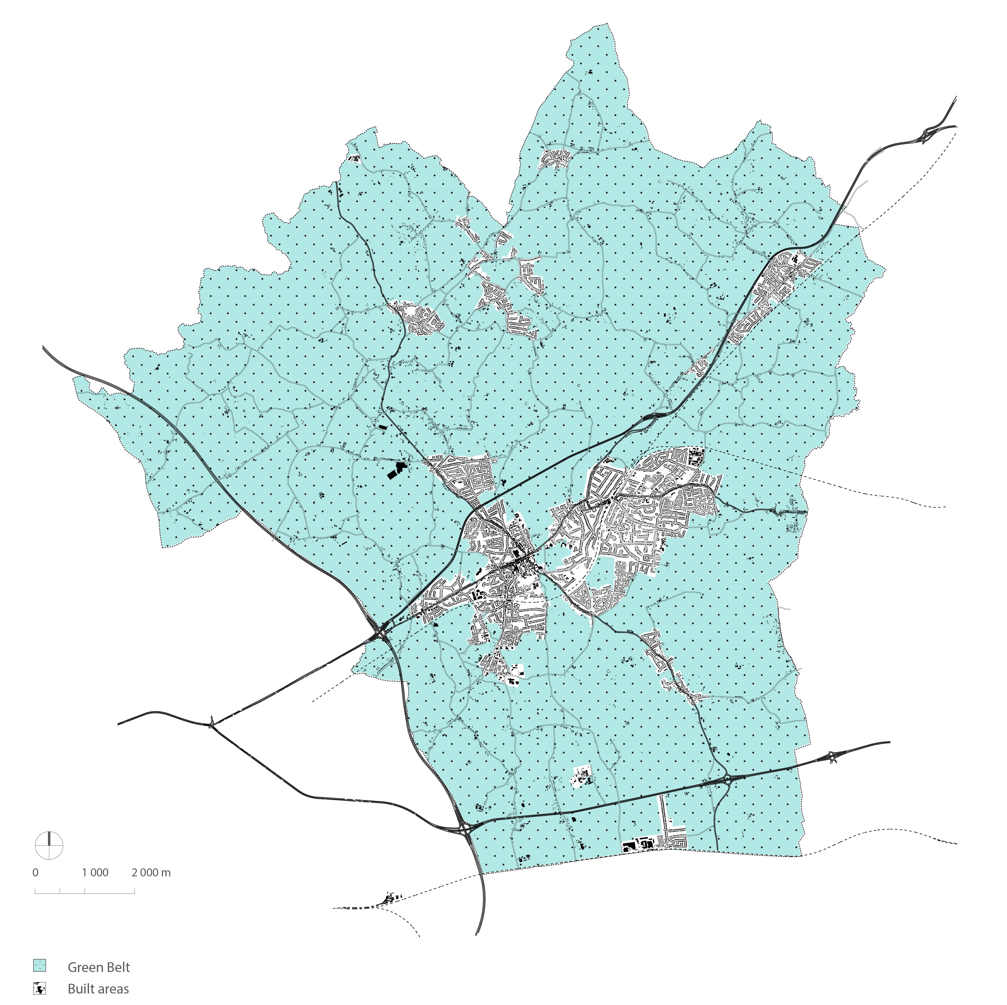
(3)FIGURE 9.2 Metropolitan Green Belt.
(25)POLICY 9.8: GREEN BELT
The Metropolitan Green Belt boundaries within Brentwood Borough will be maintained in order to continue to serve its key function, and be protected from inappropriate development, and to:
- Preserve the Borough's special character and landscape setting;
- Check the growth of London and prevent ribbon development and urban sprawl;
- Prevent the coalescence of settlements;
- Assist in safeguarding the countryside from encroachment; and
- Assist in urban brownfield land reuse, by encouraging the recycling of derelict and other urban land.
Development proposals within the Green Belt will be assessed in accordance with national policy and guidance. Development within the Green Belt will only be permitted if it maintains the Green Belt's openness and does not conflict with the purposes of the Green Belt or harm its visual amenities.
Policy 9.8 contributes towards achieving strategic objectives SO1, SO2, SO5, SO7 and SO8.
9.49 Green Belt is a policy designation which keeps land permanently open to prevent urban sprawl. The historical development of Brentwood has led to the current central, urban areas of Brentwood and Shenfield, separated by green wedges of Green Belt. The majority (89%) of the Borough lies within the Green Belt and comprises a mix of villages, residential properties and agricultural land. This significantly limits land available for development within the Borough and has created the sharp contrast between urban and rural areas with little or no urban fringe.
9.50 There are large areas of woodlands, golf courses, playing pitches, parks and an extensive network of public rights of way providing public access to open countryside. The Green Belt contains extensive areas important for nature conservation including Hutton, Weald and Thorndon Country Parks, three Sites of Special Scientific Interest (SSSI) and 147 Local Wildlife Sites. The Thames Chase Community Forest reaches across much of the south western area of the borough.
9.51 In order for Brentwood Borough to grow economically and to provide adequate housing for its population, land must be made available for such growth. Failure to do so might undermine the future prosperity of the Borough. The proposed decamping of various existing employment sites onto a new strategic employment location at Junction 29 of the M25 releases further locations for sustainable housing development on brownfield sites. These locations have the ability of immediate access to existing communities and infrastructure.
9.52 To ensure the Metropolitan Green Belt continues to serve its key functions within Brentwood Borough, it will be protected from inappropriate development.
9.53 Any development proposal within the Green Belt will be required to demonstrate very special circumstances sufficient to outweigh the harm to the Green Belt together with any other harm identified. Development will be restricted to those limited types of development which may be allowed in exceptional circumstances within the Green Belt.
9.54 Notwithstanding the above, further development within the Green Belt will need to meet the requirements of Green Belt policy in the NPPF, be in accordance with other policies in this Plan, does not harm its visual amenities and not compromise the openness of the Green Belt, or increase the risk of urban sprawl.
(20)POLICY 9.9: NEW DEVELOPMENT, EXTENSION AND REPLACEMENT OF BUILDINGS IN GREEN BELT
Within the defined Green Belt, changes of use of land, the construction of new buildings, the extension or re-use or replacement of existing buildings is considered inappropriate and will not be permitted.
In assessing proposals for new development in the Green Belt the Council will also have regard to the objective of maintaining the openness, function and permanence of the Green Belt and:
- the protection of the general character and appearance of the rural area;
- the effect of the proposal on public rights of way;
- whether the proposal will diminish or support people's, tranquil enjoyment of the countryside; and
- the need to preserve or enhance existing landscape and ecological features.
Proposals for small scale buildings and facilities required for outdoor sport and recreation will need to demonstrate a justifiable need for such buildings and facilities. Any ancillary social facilities provided as part of the development should be incidental to the primary use of the site, restricted in size and solely for use of persons participating in the recreational activity on the site and shall be permanently retained as such.
The expansion or intensification (including extensions) of existing inappropriate development within the Green Belt will not be permitted. The replacement of existing buildings may be allowed provided the visual mass of the new building does not exceed the mass of existing buildings and the proposal would not lead to an expansion or intensification of activity on the site.
Extension of a domestic curtilage into the Green Belt will not be permitted.
Proposals to extend dwellings within the Green Belt (other than those identified in Policy 9.10) will be permitted in exceptional circumstances, in order to ensure the new building is not materially larger than the original, provided all the following criteria are met:
- the existing dwelling is lawful, permanent, designed and originally constructed for residential use;
- a substantial and identifiable part of the original dwelling remains in place;
- the total size of the dwelling as extended (including conservatories) does not exceed the original habitable floor space by more than 30%;
- the design of the extension is appropriate to the host building and its setting and does not harm the openness or function of the Green Belt; and
- application to extend domestic curtilage into the Green Belt will not be permitted.
Extensions to replacement dwellings will only be permitted where the habitable floorspace of the replacement dwelling and the total habitable floorspace of any extensions permitted together with that applied or would not be greater than 30% above the original habitable floor area of the previous dwelling which had been replaced.
Where appropriate, a condition will be imposed to prevent this habitable floorspace limitation from being exceeded through the implementation of permitted development rights.
Extension of a dwelling resulting, from the conversion of a rural building will not be permitted, notwithstanding permitted development rights.
Outside settlements and established areas of development listed in Policy 9.8 and Policy 9.10, the replacement or substantial rebuilding of permanently occupied dwellings will only be allowed subject to the following criteria:
- where the existing dwelling has not been previously
extended or where it has been extended by less than 30%
above the original habitable floor space:
- The floor space of the replacement dwelling will be no larger than 30% above the original habitable floor space, or
- where the existing dwelling has been extended by more
than 30% above the original habitable floor space:
- the replacement habitable floor space of the replacement dwelling will be no larger than the existing habitable floor space.
- The visual mass of the replacement dwelling should be no greater than that of the existing dwelling;
- Where the original, existing dwelling is a bungalow it should be replaced by a bungalow; and
- any replacement dwelling will be expected to be located in the position of the existing dwelling except where the local planning authority considers an alternative siting to be more appropriate in green belt or amenity terms.
- Where appropriate, a condition will be imposed removing permitted development rights to extend the building, use the roof space for habitable purposes and erect walls, fences or further out-buildings
(This policy is not intended to relate to uses created via the re-use of rural buildings).
Policy 9.9 contributes towards achieving strategic objectives SO1, SO2, SO5, SO7 and SO8.
(2)All Development
9.55 Green Belt policy aims to prevent urban sprawl by keeping land permanently open. The essential characteristics of Green Belts are their openness and permanence. The sensitive wedge of open countryside in which Brentwood is situated is a good example of the Green Belt's success in halting London's outward spread and protecting the character and setting of Brentwood town. Proximity to London and attractive countryside means that the Borough experiences considerable development pressure.
9.56 Uses which are appropriate in the Green Belt include agriculture and forestry buildings; appropriate facilities for outdoor sport outdoor recreation and cemeteries as long as these preserve the openness of the Green Belt; extension or alteration of a building provided it does not result in disproportionate additions over and above the size of the original building; the replacement of a building, provided the new building is in the same use and not materially larger than the one it replaces; limited infilling in villages, and limited affordable housing for the local community; the partial or complete redevelopment of previously developed sites (brownfield land) and does not have a greater impact on the openness of the Green Belt; and the re-use of buildings provided that the buildings are of permanent and substantial construction.
9.57 The Council will encourage the beneficial use of the Green Belt, through opportunities to improve access, outdoor sport and recreation; retain and enhance landscapes, visual amenity and biodiversity; or improve damaged and derelict land.
9.58 The following settlements are excluded from the Green Belt as identified on the Proposals Map: Blackmore, Brentwood, Doddinghurst, Herongate, Hook End, Hutton, Hutton Mount, Ingatestone, Ingrave, Kelvedon Hatch, Mountnessing, Pilgrims Hatch, Shenfield, Stondon Massey, West Horndon and Wyatts Green.
9.59 Microgeneration integral to individual new development are encouraged, and may be acceptable under permitted development. Where not permitted development, the renewable energy installations should not impact on the openness, function and permanence of the Green Belt or conflict with the purpose of the land within it. Proposals for larger scale renewable energy projects in the Green Belt will comprise inappropriate development (NPPF Paragraph 91) and therefore only in very special circumstances will they be permitted.
9.60 Temporary and permanent Traveller sites are inappropriate development in the Green Belt. However, certain existing sites are proposed to provide permanent provision, as set out in Policy 7.10.
Dwelling Extensions
9.61 Existing dwellings in the Green Belt benefit from the same permitted development rights as dwellings elsewhere (provided permitted development rights have not been removed). Extensions to properties can, however, lead to urbanisation, increases in population and activity in the Green Belt, and a loss of small dwellings. This policy therefore seeks to minimise harm caused to the Green Belt that might otherwise result from disproportionate additions and by resisting the loss of smaller dwellings, help maintain a choice of dwelling sizes in the Borough.
9.62 The policy reference to "original" means the dwelling as existing on 1 July 1948 even if the original dwelling has since been replaced. Where no dwelling existed on the date then "original" means the dwelling as first built. Extensions will only be allowed under the policy where the dwelling proposed to be extended remains intact on site. For the purposes of calculating floor space, gross internal measurements are used in all cases. This means measuring from the inside of external walls and includes the area of internal partitions, but excludes any stairwell area above ground floor.
9.63 Extension of domestic curtilages into the Green Belt leads to further urbanisation though construction of hardstandings, walls, sheds, etc as well as increased activity generally, and change from rural to suburban/urban character is contrary to the aims of the Green Belt.
Replacement Dwellings
9.64 Where new dwellings are permitted in the Green Belt on grounds of very special circumstances the Council will consider removing permitted development rights for extensions and outbuildings to prevent future additions where these cumulatively would add to the impact of the development on the Green Belt. Proposals to extend or erect outbuildings to such dwellings will not be permitted.
9.65 Criteria for replacement dwellings and substantial rebuilds set out in the policy are necessary to limit the amount of urbanisation that takes place in the Green Belt through increased occupancy potential and the inevitable visual impact resulting from redevelopment and the use of modern building materials.
9.66 The floorspace of replacement dwellings in the Green Belt may be up to 30% greater than the original habitable floorspace. Subsequent further extensions to a replacement dwelling will only be allowed where this additional 30% was not provided to the full at the time the replacement dwelling was built. This allowance provides the opportunity to design a building that meets the aspirations for more accommodation while ensuring the overall visual mass is no greater than that of the original dwelling. The presumption that bungalows will be replaced by bungalows should help minimise the impact on the Green Belt and assist in the provision of accessible property in the Borough.
9.67 In the interests of amenity, certain permitted development rights will, where appropriate, be removed by a condition attached to the permission. These might cover the erection of walls/fences and outbuildings. When property is rebuilt, the investment involved is very likely to spread into the renewal of boundary treatment and the provision of garages or other measures which could have a strongly urbanising effect if not controlled.
9.68 In order to retain the integrity of the criteria applied to the re-use of rural buildings, the replacement of a dwelling formed under Policy 9.14 Reuse and Residential Conversion of Rural Buildings will not be permitted.
(13)POLICY 9.10: ESTABLISHED AREAS OF DEVELOPMENT IN THE GREEN BELT
Within established areas of frontage ribbon development included within the Green Belt listed below, planning permission for change of use to residential, new residential development on genuine infill plots, replacement of existing dwellings, or extensions to existing dwellings will be allowed subject to criteria set down in other policies in this plan being satisfied.
Relevant frontages are:169-293 Chelmsford Road; 39-47, 51-109 Coxtie Green Road; 1-19 Bellhouse Lane; Between Coppersfield And Greenoaks, Doddinghurst Road (Parkwood); 1-13 (Excluding 2), 21-56 (Excluding 24, 26) Nags Head Lane; The Thorns/The Briars, Ongar Road; 54-88 Billericay Road; 554-664 Rayleigh Road.
9.69 Within the Green Belt there are many established clusters of dwellings. The Locations listed reflect planning consents that have occurred since the 1976 review of Green Belt boundary and the policy does not seek to create exceptions to the general Green Belt protection policy.
9.70 National policy and guidance regards the construction of new buildings as inappropriate in Green Belt but includes limited infilling in villages, and limited affordable housing for local community needs, if proposed in policies in the Local Plan, may not be inappropriate.
9.71 Continuing pressure exists for ribbon "infill" development to take place between existing dwellings. If this pressure were acceded to, the character of the Green Belt within and around these areas would be irrevocably damaged over time and would result in the coalescence of villages and towns. The Council will, therefore, continue to resist strongly pressure to allow new development in those established clusters. However, there are a very few limited, well defined areas within the Green Belt where tight knit frontage ribbon development already exists which is sufficiently urban in character to allow some relaxation of Green Belt policy. Outside these defined areas, residential development will be permitted only in accordance with other policies in this Plan.
(42)POLICY 9.11: PREVIOUSLY DEVELOPED LAND IN GREEN BELT
Proposals for redevelopment of previously developed sites (brownfield) within the Green Belt will be permitted where redevelopment:
- contributes towards local housing needs or provides new jobs;
- would not have significantly greater impact on the openness of the Green Belt;
- provides community benefits to both the new and existing local community;
- supplies or improves travel links to nearby existing communities, such as villages; and
- contributes to the Borough's sustainable development principles as set out in other policies in the Plan.
9.72 Policy 9.11 is in place to recognise the potential opportunity provided by previously developed sites in the Green Belt to meet local needs. Such sites will be considered appropriate for redevelopment where they contain permanent buildings and are redundant or in continuing use, subject to meeting the policy criteria.
9.73 Previously developed sites in Green Belt provide locations to meet local housing needs within the existing development context of the Borough. However, such sites are usually divorced from urban settlements, often remote, and do not provide for more than 10 new homes on site. For these reasons sites have not been identified and allocated for development. Although such sites do not meet the proposed spatial strategy for focusing new development in sustainable locations, they can allow for limited development appropriate for local surroundings and as part of the purpose for including land within Green Belt.
9.74 Such sites can contribute to local need, particularly in the Borough's rural areas, supporting villages by contributing to local services and providing new homes to allow for improved choice. It may also be appropriate for redevelopment to provide for other types of need, such as new jobs.
(49)POLICY 9.12: SITE ALLOCATIONS IN GREEN BELT
Sites allocated to meet housing needs in Green Belt will be expected to provide significant community benefit, both for surrounding existing communities and those moving into new homes on site. There will be a mix of housing on site to provide for a range of needs as indicated by evidence.
These sites will be de-allocated from Green Belt to allow development to take place and provide new defensible boundaries to protect open countryside for future generations.
The extent of development at Dunton Hills Garden Village will be de-allocated from Green Belt, to be set by a separate Masterplan for the garden village.
9.75 Policy 9.12 is in place to ensure the cost of losing some Green Belt is repaid through significant benefits to new and existing communities. This will capture the uplift in land value for local benefit. These benefits are likely to be for different needs depending on the area, but could involve new community facilities, open space for public use, play areas, and investment in existing facilities. In addition, development will need to contribute to local education and healthcare needs in partnership with relevant providers/authorities.
9.76 New housing development in these locations will provide for a range of needs as advised by evidence, such as the Council's Strategic Housing Market Assessment, and local housing strategy. This could be to provide new starter homes, medium and larger family homes, and smaller units, for example to allow older people to have a realistic option to downsize and free up larger homes for families. Such new homes will be fit for purpose to meet specific needs, meaning not all smaller units will be flats.
9.77 With this in mind, it will also be necessary to ensure the most efficient use of land is made in order to respond to the Borough's higher housing need and limited capacity. Balancing development needs with Borough character in line with strategic objectives and the spatial strategy will need to be considered.
9.78 Policy 9.12 also sets out the principle of removing allocated Green Belt development sites from the Green Belt. This de-allocation will allow for planning applications to be considered within the context of policies within this Plan as well as national policy and guidance.
Agricultural Workers Dwellings
9.79 The Council will protect the Borough's rural areas from development that would adversely affect landscape character, appearance, and function, by avoiding non-essential residential development. The Council also recognises that the maintenance of land in agricultural use helps the preservation of the rural area. However, to enhance and maintain the vitality of rural communities, exceptions may be made for the conversion of existing buildings, one-for-one replacement of existing dwellings, or where it is a proven, a new dwelling to support an agricultural worker's employment requirements to live in close proximity to their place of work.
(1)POLICY 9.13: AGRICULTURAL WORKERS DWELLINGS
New Dwellings
Planning permission will only be granted for a new
agricultural, horticultural, forestry worker's dwelling
where:
- evidence has been submitted to the satisfaction of the Borough Council that there is a viable agricultural, horticultural or forestry business need for a permanent dwelling in that location;
- there are no suitable alternative dwellings available or could be made available in the locality to meet the needs of the agricultural holding;
- the size and accommodation levels to be included in the proposed dwelling is commensurate with the needs of the holding; and
- the development is in all other respects acceptable against other relevant policies in the plan.
Conditions will be attached to any permission limiting the occupancy to that required for the holding concerned or other agricultural use nearby.
Removal of Occupancy Conditions on Existing
Dwellings
Planning permission will be granted for the removal of a
restrictive agricultural worker occupancy concerned or
other agricultural use nearby where it can be evidenced
that there is no longterm need for an agricultural worker's
dwelling in the locality.
Policy 9.13 contributes to strategic objectives SO1, SO2, SO5, SO7, and SO8
9.80 It is recognised that in some limited circumstances there may be a need generated for new dwellings to solely serve workers engaged in agriculture, forestry and other rural activities. The new dwellings section of Policy 9.13 provides criteria whereby proposals for new agricultural, horticultural or forestry workers dwellings will be assessed.
9.81 In addition, changes in the scale and character of agricultural and forestry activities could affect the longer-term requirements for dwellings in the rural area where these were made subject to an agricultural horticultural or forestry worker occupancy condition at the time planning permission was granted. In such cases, it is recognised that it would fulfil no purpose to keep such dwellings vacant, or that existing occupiers should be obliged to remain in occupation simply by virtue of a planning condition that has outlived its usefulness. Nevertheless, the Council will expect applications for the removal of an occupancy condition to demonstrate convincingly there is no long-term need for an agricultural dwelling in the locality.
9.82 Moreover, the Council will bear in mind that such dwellings could well be used by agricultural, horticultural and forestry workers seeking accommodation within the wider surrounding area. In this regard the Council will need to be assured that the availability of a dwelling tied to an occupancy condition has been effectively marketed to likely interested parties in the area concerned, and that no real interest has been shown regarding purchase or occupation of the dwelling by the local agricultural community.
9.83 As part of the evidence required, the applicant will be expected to provide details of their instructions to estate agents, and the response to that advertising, that:
- the property has been on the market for rent or sale for at least two years and advertised continuously in that period at a price that reflects the occupancy condition. The advertising should be within both local newspapers and at least two national farmer magazines e.g. Farmer's Weekly; and
- the property has been offered both for sale and to rent on the same basis as above to all farmers and horticulturists in the locality (i.e. having holdings within a 3.2km (two mile) radius of the dwelling).
9.84 In addition, Policy 9.13 will be applied to applications for the removal of occupancy conditions from dwellings associated with stables or other rural dwellings which are subject to occupancy conditions.
Re-use and Residential Conversion of Rural Buildings
9.85 Notwithstanding prior approval permitted development rights for the change of use of agricultural buildings of 500 square metres or less, to Class R, the re-use and adaptation of existing rural buildings can play an important role in meeting the needs of rural areas for employment, tourism, leisure and/or community uses. In addition, the re-use of rural buildings for commercial development can support the rural economy by promoting the sustainable growth and expansion of businesses through conversion of existing buildings and diversification of agricultural and other land-based rural businesses. Tourism could be a vital and sustainable source of business for the rural economy and provides employment for local people and therefore contributing to the objective of sustaining vital rural communities. Some buildings could be suitable for businesses connected with tourism, while community uses can make a valuable contribution to local communities in appropriate locations.
(2)POLICY 9.14: RE-USE AND RESIDENTIAL CONVERSION OF RURAL BUILDINGS
The Council will support the re-use, conversion or adaptation of rural buildings for other employment generating uses, tourism, leisure or community or residential use provided the development proposal meets all the following criteria:
- it does not have a greater impact on the openness of the Green Belt and the purpose of including land within the Green Belt than the original or current lawful use;
- the new use should not require elements which might conflict with the openness and function of the Green Belt;
- the applicant can demonstrate that the building is of permanent and substantial construction; and
- The conversion of the building would not result in a major or complete reconstruction.
With regard to changes of use or conversion to residential:
- the location is suitable for housing;
- the building proposed for conversion must be located within or directly adjoining a small group of buildings, and
- the proposed re-use should not have an unacceptable detrimental impact on the fabric and character of the building due to unsympathetic changes to, or the introduction of, features such as windows, door openings and chimneys
- the residential use is a subordinate part of a scheme for business re-use;
- the use is essential to enable a farm or forestry worker to live at or near their place of work; or
- evidence has been provided to demonstrate that no other suitable alternative uses can be found and conversion would lead to an enhancement to the building's immediate setting.
In the case of traditional rural buildings, the proposed use must be compatible with the historic character and significance, and structural integrity of the building. A historic building assessment of the structures may be required as part of the planning application with the potential for a full historic record to be completed as a condition of the application prior to conversion.
Where appropriate, conditions will be imposed removing permitted development rights to extend the property, alter the external appearance, construct buildings or structures (including walls/fences) within the curtilage, and change the use.
Permission will not be granted for the re-use of an agricultural building erected under Class A of Part 6 of Schedule 2 of the General Permitted Development Order as amended within 10 years of its substantial completion.
Policy 9.14 contributes to strategic objectives SO1, SO2, SO5, SO7, and SO8.
9.86 Notwithstanding prior approval (under the provisions of paragraph W) permitted development rights for the change of use of agricultural buildings (under the Town and Country Planning (General Permitted Development) (England)) Order 2015, of 500sqm or less, to Class R. Class R. This does not apply to a Listed building or a scheduled monument.
9.87 Where a solely used agricultural building prior to 03/07/2012; smaller than 500sqm; will have prior approval for a flexible use as Class A1 (shops), A2 (financial), A3 restaurants, café, B1 (business), B8 (storage/distribution), C1 (hotels) or D2 (assembly and leisure). NB between 150sqm and 500sqm, prior approval will need transport and highways impact, noise impact, contamination risk, flood risk information to be submitted.
9.88 The Council is committed to supporting a prosperous rural economy and this approach is in line with national policy. This policy should be read in conjunction with Policy 8.5 Supporting the Rural Economy.
9.89 Residential re-use is a concern due to the large number of properties involved, loss of rural business premises for which there may be a need in future but which may be uneconomic or otherwise hard to replace, the impact on the rural character of the Green Belt and the need to facilitate new housing within or well connected to existing settlements. The Council will generally apply a presumption in favour of employment generating uses. Residential conversions will only be permitted where every reasonable effort has been made to secure a suitable business use, or the residential use is a subordinate part of a business re-use, or the use is required for an agricultural or forestry worker. Residential conversions may be appropriate in certain circumstances including where they are adjacent to, or within, existing groups of buildings. A financial contribution will be sought by the Council towards the provision of affordable housing elsewhere within the respective Parish.
9.90 In the case of traditional rural buildings, the proposed use must secure its historic fabric and integrity and in the case of Listed Buildings will need to comply with Policy 9.5. It is essential to ensure that a residentially converted rural building does not have the appearance of a new dwelling or set a precedent for new residential development in the Green Belt. The building must be capable of conversion without the creation of a residential curtilage having a harmful effect on the building and the surrounding countryside due to the unacceptable intrusiveness of increased activity and domestic additions such as garaging, sheds, clothes lines, play equipment, walls and fences, patios and hardstandings.